
A lost Maya city was found by archaeologists in the southern Mexican jungle. According to a statement from the Mexico National Institute of Anthropology and History (INAH), the site is situated in the Balamkú natural reserve in the state of Campeche's central region.
Archaeologists believe that the location, which has a number of substantial pyramidal buildings, was a significant center in the area during the Classic period of the Maya civilization (about 250–1,000 A.D.).
Up until the time of Spanish colonization, the Maya civilization ruled over what is now southeast Mexico, Guatemala, Belize, and the western regions of El Salvador and Honduras for more than 3,000 years.
They are known for their spectacular architecture and artwork, as well as their sophisticated calendar, mathematics, and astronomical system. They also devised the only fully developed writing system in pre-Columbian America.
Ivan Prajc's group of archaeologists made the most recent find at the "monumental" Maya site at Balamkú.
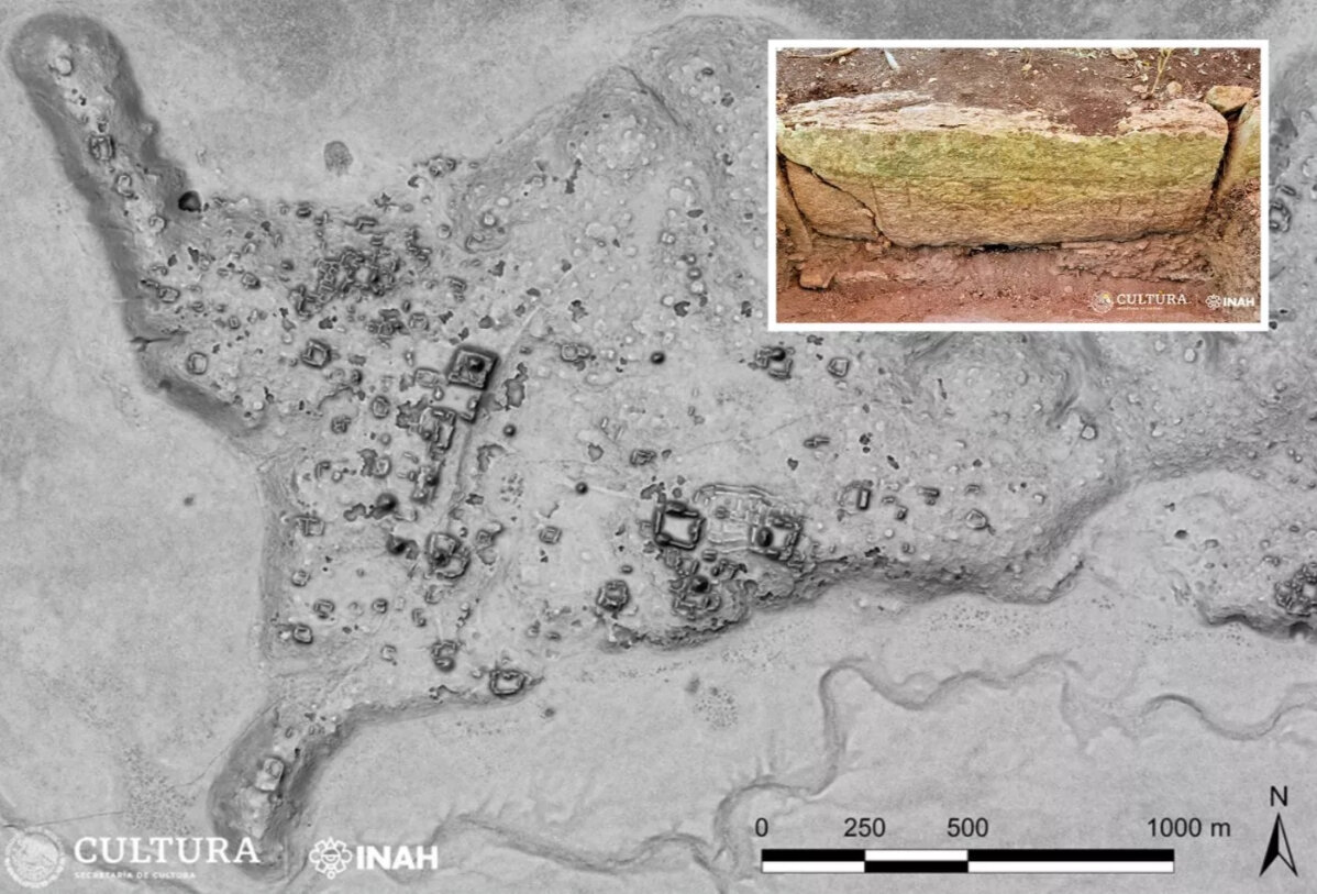
Because of the numerous cylindrical stone columns that are sprinkled all throughout the prehistoric settlement, the study team has given the location the name "Ocomtn," which means "stone column" in the Yucatec Maya language. The columns probably served as entrances to the upper rooms of the city's structures.
The site was found as a result of an INAH-approved research initiative that sought to learn more about a vast, mainly unexplored region in the state of Campeche that was essentially unknown to archaeologists.
Researchers employed LiDAR technology and aerial surveys to identify many pre-Hispanic structures as part of their research in this region.
LiDAR uses equipment mounted on aircraft that fires laser light pulses at the ground at a rate of hundreds of thousands per second. The information gathered is then utilized to produce intricate 3D maps that depict the topography of the area and any previously hidden features created by ancient humans.

Archaeologists also carried out fieldwork, traveling nearly 40 miles through dense vegetation to get to the location.
According to Prajc, investigators discovered three plazas in the southeast corner of the site that were dominated by massive structures. There is a complex made up of different low, elongated buildings that are grouped practically in concentric circles between the two main plazas. A ball court that was used for pre-Hispanic ball activities was also found by researchers.
Archaeologists estimate the height of one pyramid, which is situated in the northern portion of the site, to be about 82 feet (25 meters), while others can reach heights of up to 50 feet (15 meters).
The site's location on a "peninsula" of high ground, encircled by vast wetlands, ended up being the biggest surprise. Its imposing core is more than 50 hectares in size and is home to a number of big buildings, including numerous 15-meter-tall pyramidal constructions.
Maybe throughout the classical era, the location operated as a significant regional center.
Architectural remains at the site suggest that the village experienced a fall during the Terminal Classic period (800–1,000 A.D.), a turbulent time for Maya civilization.
This data shows how ideologies and populations changed throughout times of crisis, which ultimately resulted in the breakdown of the intricate sociopolitical structure and a sharp fall in population in the Maya Central Lowlands by the 10th century.


