Impressive are the photos of the finds brought to light by the archaeological shovel in Thessaloniki, Greece's 2nd biggest city, during the construction of the local metro facilities.

In 2012, during the excavations carried out at the "Amaksostasio" of the main line of the Metro, in Pylaia, a pre-Cassandrian small town of the 4th century BC came to light. An area of 31 acres was investigated and part of the city was revealed, which was organized with the Hippodamian urban planning system, following the standards of the great cities of Macedonia, Olynthos and Pella.
The numerous finds point to a prosperous settlement with a strong economy and developed socio-political structures. Its great development is placed in the second half of the 4th century. BC, which was however interrupted by the founding of the city of Thessaloniki by Kassandros in 315 BC, when it was abandoned.
Another interesting find is the cemetery of Roman times (2nd -4th century AD) that was investigated in the limits of the Fleming Station and revealed to us aspects of a hitherto unknown settlement, on the outskirts of ancient Thessaloniki.

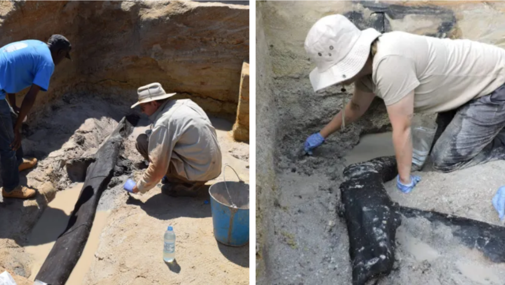
During the construction works of Thessaloniki METRO, at the stations near Aristoteleion University, the archaeological research revealed a large part of the eastern cemetery of the city, as well as a three-kilometer cemetery Basilica with mosaic floors on the site of an older building. In particular, it brought to light thousands of funerary monuments (3000) which have come to enrich our knowledge so far about the organization and continuous use of the space from the Hellenistic period to Late Antiquity.
The tombs belong to various types, pit-shaped, box-shaped, pot burials, altars, altar-shaped constructions, single or double vaulted, decorated with clay and glass vessels, clay figurines, gold and silver jewelry and coins.

The excavations carried out at the two stations within the historical center of Thessaloniki, the Agia Sophia Station and the Venizelos Station, complete the topographical map of the city, at the level of the main thoroughfare, today's Egnatias Street. The findings outline the urban planning organization of the urban space of Thessaloniki from its foundation to the end of late antiquity.
The city was designed in its lowland parts with the Hippodamian urban planning system. Streets, perpendicular to each other, form building islands with residential and laboratory buildings.

The same design is preserved in Roman times, with small-scale alterations to the building plan. In the 4th c. A.D. the now marble-paved streets are flanked by colonnaded arcades and on either side of them are erected large building complexes with luxurious mosaic floors, wall written decoration, marble cladding and opus sectile. At the same time, to the north of the decumanus, at the junction with the cardo of the Agia Sophia street, a cistern building/nymphaeum was constructed that shows overlapping building phases. A drastic intervention in the urban planning of the city takes place in the 6th century: the marble-paved decumanus is widened, the older buildings are leveled and in their place paved squares are formed at the central crossroads of the city.
Those imposing architectural configurations of the public space - squares, arcades and fountains/nymphaea - along the central streets are the last monumental image of late antiquity.

The excavation research in the two stations of the historical center of Thessaloniki revealed parts of the Byzantine market along the main street, the so-called Avenue or Middle of the Byzantines.
The central cobbled street of Byzantine times was revealed, in the trace of the older decumanus maximus with an average width of 5.5 to 6.5m. New roads with a straight, winding and diagonal course are drawn or existing ones change their course, simultaneously defining the extent of the building islands. The islands of mud-built buildings occupied the public space, the sidewalks and the arcades of late antiquity. These are workshops and shops of a market where jewelry, articles of metalwork, glasswork, ceramics, etc. are produced. Brick constructions, kilns, work benches, together with tools, jewelry making molds, unfinished ceramics, tripods, attest to the productive use of the premises throughout the Byzantine period.

During the Ottoman period, the urban planning changes do not seem to be radical. After all, the building remains were found disturbed by the basements of the buildings of more recent times.
The upper layer found at both stations provided evidence for the urban planning organization of Thessaloniki during the last period of the Turkish occupation (second half of the 19th century CE). marked by urban changes aimed at creating a city designed according to European standards. The buildings they excavated, mainly underground, were found destroyed by the fire of 1917 that burned down the center of Thessaloniki and was the springboard for the design of the modern city.

The stations in the west city are located in the countryside outside the old walls of Thessaloniki. The excavation research carried out in sections by periods, during the years 2009 – 2012, 2016 -2017, when it was completed, supplemented our knowledge over time from the 3rd c. BC until recent times for the spatial development of the peri-urban western zone.
The spatial organization of the area was dictated by two parameters: the passage of the main road, the well-known Roman Egnatia road that connected Thessaloniki with Pella, and the flowing streams. Overlapping gravel and earthen pavements of the road, which reached outside the Golden Gate crossing the Keramisious plain and the cemetery, were located under today's Monastiriou Street.

At the New Railway Station is a bypass and developed along the northern side of this road axis. Organized into clusters it includes a variety of tombs and altar-like structures - usually within burial enclosures, providing spaces for funerary ceremonies and offerings. Marble sarcophagi and luxurious burial buildings of the 2nd, 3rd and 4th c. AD stand out.
The period of use of the necropolis covers a long period from the 3rd century BC. up to the middle of the 4th c. AD, when Christian cemeteries are organized around cores with religious buildings, temples and martyrdoms. Later, and mainly from the 6th c. A.D. sporadic burials continue. which do not constitute an organized cemetery.


The excavation at the station and the entrances of the Democracy Square, on the outskirts of the necropolis, just a few meters outside the western walls, brought to light on either side of the road that led from the countryside to the Golden Gate, large complexes of state wine and oil warehouses (pytheon ) and laboratories of late antiquity.
On the ruins of the python, it was founded in the 5th century a square temple with a funerary addition, storerooms and workshops. At the end of the 6th c. – beginning of the 7th c. the temple and its facilities are completely destroyed and abandoned. Among its hallowed ruins are sporadic burials. Building activity is limited to the south. In the following centuries the area remained undeveloped, not by chance, after all, it was called by the Ottomans Ҫayir, i.e. Meadow or Meadow. As soon as the late 19th c. will regain its commercial character, when inns, shops and warehouses are built on the axis of Monastiriou Avenue.