
An acropolis that has kept its secrets for thousands of years is being investigated by archaeologists in what was once the greek colony of que me in italy. The elite of the region are typically buried in long, sealed tombs here, according to these specialists. However, inside one of these vaults, the group finds a complex mural that brings to light a long-forgotten past. The hidden history of an ancient italian city has been revealed by the mesmerizing 2000-year-old mural. Ever since the phoenicians first arrived on the shores of what is now italy in the 10th century bc, this mediterranean country has been a melting pot of different cultures. But even though the romans arguably take up most of the pages in school history books today, the truth is that many different civilizations have left their marks on this part of the world. Back in the eighth century bc, for example, the homeland of the ancient greeks was under threat. So spurred on by crises such as climate change and famine, the greek spread out to colonize and trade with other lands, and soon enough, greek settlements had sprung up in sicily and on the italian peninsula.
The prehistoric origins of the Silk Road
In an expedition through the Central Asian steppe, a group of Kazakh and European archaeologists search for clues left by early Humans and Neanderthals - they are investigating the prehistoric origins of the legendary Silk Road.
Far before its emergence in the 2nd Century BC, and well before the silk trade, this expansive network of routes had already been 50,000 years in the making. Traversing over 2,500 km from the Uzbek to the Russian border, scientists search for traces that may hold the missing key to how extreme climatic events spurred prehistoric mass migrations, bringing an unprecedented encounter between Neanderthals and Homo sapiens.
These discoveries will help explain how climate change and geography fueled key genetic exchanges in human evolution, helped shape the structure of modern Asian populations, and later enabled the explosion of culture and trade along these routes. Their findings show how humans coped with inhospitable environments and cemented the nomadic cultures still present in modern-day Kazakhstan.
The Most Unbelievable Discoveries Made In The Ice
In today’s video we will be exploring the most unbelievable discoveries made in the ice. Enjoy!
What If Vesuvius Volcano Erupted in 2020?
How massive will the destruction be if the most famous volcano erupts again? What cities will suffer, how many people will die and what will it cost all of humanity? Watch the video to find out more!
Around 200 medieval skeletons unearthed at Pembrokeshire beach
Around 200 well-preserved medieval skeletons have now been recovered from one of Britain's best beaches, archaeologists say, including 90 in the last three weeks alone.

The bodies, believed to belong to an early Christian community, are thought to date back as far as the 6th century and were laid to rest in the cemetery of a former chapel at Whitesands Bay in Pembrokeshire, Wales.
They are well preserved because they have been buried in sand at what was once a medieval trading post with Ireland.

Excavation work is ongoing at Whitesands Bay, a Blue Flag beach near the city of St David's, which used to be the location of the chapel, called St Patrick's.
The skeletons were found just below the surface of the dunes where the chapel's cemetery used to be, exposed by natural erosion and storms.
They are now being preserved by experts at the University of Sheffield.
Preservation of the bones is 'absolutely incredible' because the skeletons have been immersed in sand, according to Jenna Smith at Dyfed Archaeological Trust, which is leading the dig.

'We've lifted over 90 burials in the last three weeks,' Smith told the BBC.
'It's really important that we do so because it gives that snapshot in time which we don't normally get in Wales. The bone doesn't normally exist.
'And the main reason that we're here is because we are here to stop the bones and the burials from eroding into the sea.'

Analysis by the University of Sheffield revealed the burials were of all ages and a mix of men, women and children and are likely to date between the 6th and 11th centuries.
All the graves were aligned with the head pointing west and with no possessions, in keeping with early Christian burial traditions.
Some of the skeletons were found to be in cists – graves lined and capped with stone slabs, a burial tradition common across western Britain in the early medieval period.
Some of the child burials were also found with white quartz pebbles placed on the top of the cists.
Whitesands Bay has been the focus for archaeologists since the early 1920s, because of St Patrick's Chapel and its associated cemetery.

It reads: 'Capel Patrick [is] full west of St Davids and placed as near his country, namely Ireland, as it could well be. It is now wholly decayed.'
Although the cemetery is thought to have been in use from the 6th century, the chapel is believed to have been built in the 11th century and was reportedly decayed by the 16th century.
Remains of the building were first excavated in 1924 when a cross-incised stone was found.
As for the burial ground, erosion continued to affect the site so badly that human remains periodically became exposed from the sand, before finally the graves were excavated in 1970.
There was an attempt by Pembrokeshire Coast National Park Authority to protect the burial site in 2004 when large boulders were placed on the dunes to try to slow erosion.
However, in 2014 stormy weather ripped the boulders away and exposed further burials, leading to a large-scale rescue excavation by Dyfed Archaeological Trust, followed by two further seasons of excavation in 2015 and 2016.

By 2016, efforts had revealed over 100 burials, but more found remains over the six-week excavation has brought the total to about 200.
The Dyfed Archaeological Trust said there is 'still a significant amount of evidence left to excavate', including an 'intriguing stone structure which pre-dates the burials'.
The excavations from Whitesands Beach are set to be stored at the National Museum of Wales.
The Lost Civilization of Atlantis: Separating Fact from Fiction
The idea of the lost civilization of Atlantis has captured the imagination of people for centuries, but there is no concrete evidence to support its existence. The story of Atlantis was first described by the ancient Greek philosopher Plato in his dialogues "Timaeus" and "Critias," where he presented it as a powerful and advanced society that disappeared in a single day and night of catastrophic earthquakes and floods.
However, there is no archaeological or geological evidence that Atlantis ever existed, and scholars believe that Plato's story was likely a work of fiction or a moral allegory. Some theories propose that Atlantis was based on the Minoan civilization on the island of Crete, which was destroyed by a massive volcanic eruption and subsequent tsunami around 1600 BCE.
Despite the lack of evidence, the story of Atlantis continues to be a popular topic in popular culture and pseudoscientific theories. However, it is important to distinguish between fact and fiction and approach the story of Atlantis with a critical and evidence-based perspective.
The Rosetta Stone - Key to Decoding Ancient Egyptian Hieroglyphs
The story of human civilization is richly embedded with codes, secrets, and mysteries. Among these, the enigma of ancient Egyptian hieroglyphs stands tall, not only for the beautiful artistry but also the knowledge they encompass. For centuries, these symbols remained an uncrackable puzzle, locking away tales of a grand civilization. That is, until the discovery of the Rosetta Stone—a monumental find that unlocked the key to deciphering hieroglyphs.
Discovery of the Rosetta Stone
In the summer of 1799, during Napoleon Bonaparte's Egyptian campaign, a French soldier named Pierre-François Bouchard chanced upon a slab of granodiorite while reinforcing a fort near the town of Rosetta (modern-day Rashid). The black slab bore inscriptions in three scripts: Ancient Greek, Demotic, and Hieroglyphs. Realizing the potential significance, the stone was sent to Cairo for further examination.
The stone's trilingual inscription was intended for priests, government officials, and the common folk of ancient Egypt. The Ancient Greek part was decipherable, prompting scholars to believe that the inscriptions contained the same message. This speculation made the stone an invaluable tool for understanding hieroglyphs.
Decoding the Hieroglyphs
The Rosetta Stone's discovery captured the imagination of linguists and scholars. One man, in particular, stood out in this quest—Jean-François Champollion, a French scholar passionate about ancient Egypt. He wasn't the only one working on the puzzle; Thomas Young, an English polymath, made significant inroads by identifying certain hieroglyphic sounds.
However, it was Champollion who made the groundbreaking discovery. By comparing the hieroglyphs to the known Greek text, he deciphered the phonetic characters and unlocked the sounds of the Egyptian language. He announced his findings in 1822, and by 1824, he had published a paper, offering the world its first glimpse into the meanings of hieroglyphs after over a millennium.
Significance of the Rosetta Stone
1. Unlocking Egyptian History: The Rosetta Stone bridged the vast chasm of time, reconnecting modern civilization to its ancient counterpart. Deciphering the hieroglyphs paved the way for understanding Egyptian history, religion, culture, and administration.
2. A Symbol of Multicultural Recognition: The trilingual inscription signifies a time when diverse cultural groups coexisted in Egypt. It underscores the importance of clear communication and mutual recognition between different civilizations.
3. Influence on Linguistics: The Rosetta Stone emphasized the importance of comparative linguistics. By comparing different scripts, researchers could uncover hidden linguistic structures, broadening our understanding of language evolution.
The Stone Today
Today, the Rosetta Stone resides in the British Museum in London. Since its arrival in 1802, it has been the cornerstone of the museum's Egyptian collection, drawing millions of visitors eager to witness the key that unlocked the language of the pharaohs.
However, the stone's stay in Britain hasn't been without controversy. Egypt has repeatedly requested its repatriation, arguing that the stone is an integral part of its cultural heritage. While discussions continue, the stone remains emblematic of the quest for knowledge and the enduring allure of ancient civilizations.
The Rosetta Stone's narrative is a testament to human curiosity and the indomitable spirit of discovery. It serves as a reminder of the interwoven threads of history and how, sometimes, a single artifact can illuminate an entire era. In unlocking the secrets of the hieroglyphs, the stone not only revived ancient stories but also underlined the significance of shared history and collective memory.
A Lost Continent Eliminated Millions Of Years Ago Turned Up In A Very Unlikely Place
When geologists from the University of British Columbia were searching for diamonds, they stumbled upon something much more precious: evidence of a lost continent here on Earth. Incredibly, some geologic samples they obtained contained fragments of material from a long-lost chunk of land that has since disappeared beneath the ocean Millions Of Years Ago. It was indeed a once-in-a-lifetime find, and the location of this lost continent is catching many historians off guard.
Mysterious Temples Found Underground
In the following video we will be exploring mysterious temples found underground. Enjoy!
Day In The Insanely Tough Life Of A Roman Slave
What was life really like for a Roman slave? Well, it depended on what kind of slave you were. If you were a household slave, you might have had it better than some others. You would have had a place to sleep and regular meals. But you would still be expected to work long hours doing things like cooking, cleaning, and running errands. And if you didn't do your job well, you could be beaten or even killed.
There is no doubt that slaves were the backbone of the Roman Empire. They were an important part of the Roman social and economic system and played a big role in the lives of Romans. Roman slavery was a horrible way to treat people.
Vampire Biology Explained | The Science of Vampirism
In today’s video someone (presumably an academic or scientist) dives into great detail regarding the science of vampires. Watch the video to find out more!
Horrific Things That Were Normal To Chinese Concubines
In the video below we will analyze how Victorian women used the bathroom in those huge dresses. Watch the video to find out more!
Strange Theories About The Ancient World
In the following video we will investigate strange theories about the ancient world. Watch the video to find out more!
How Old is Written Sanskrit?
In the video below we will investigate how old is written Sanskrit. Watch the video to find out more!
Etruscans: Italian Civilization Before Ancient Rome
The Etruscans were a fascinating and enigmatic civilization that flourished in central Italy prior to the rise of Rome, from the 8th century BCE until their culture was subsumed into the Roman Empire. They inhabited the region known as Etruria, roughly equivalent to modern Tuscany, western Umbria, and northern Lazio. The origins of the Etruscans have been a subject of much scholarly debate, with theories ranging from autochthonous development to migrations from the Near East or the Aegean region.
Etruscan society was complex and highly developed. They were known for their rich mineral resources, particularly iron, which contributed to their wealth and influence in the Mediterranean. Their trade networks were extensive, exchanging goods with Greek and Phoenician civilizations, from whom they also absorbed cultural and artistic influences. This is evident in the similarities between Etruscan and Greek pottery and the adoption of a Greek-styled alphabet that they adapted to their own Etruscan language—a language that remains only partially understood today due to the lack of substantial textual evidence.
Politically, the Etruscans were organized into city-states, much like the Greeks. These cities, such as Tarquinia, Veii, and Cerveteri, were ruled by powerful, hereditary elites. The Etruscan political system is noted for its influence on Rome, particularly the establishment of a republic and the concept of the division of powers. Moreover, several of the Roman kings during the monarchy period were of Etruscan origin, which further embedded Etruscan customs and practices into the foundation of Roman culture.
In terms of religion, the Etruscans were deeply spiritual and had a rich pantheon of gods, with which they again shared some similarities with the Greeks and Romans. They practiced divination and believed in the interpretation of omens. One of their most lasting legacies is the discipline of haruspicy, the reading of entrails, which was adopted by the Romans.
Archaeologically, the Etruscans are best known for their funerary practices, which included elaborate tombs rich in grave goods, wall paintings, and sarcophagi. The tombs provide a wealth of information about Etruscan life, beliefs, and art. They celebrated death as a transition to a different form of life, which is reflected in their joyful and colorful tomb paintings, contrasting with the more somber Greek depictions of the afterlife.
The decline of the Etruscan civilization is attributed to a combination of factors, including internal strife among city-states, resource depletion, and pressure from external forces, particularly the Romans and the Greeks in southern Italy. By the 4th century BCE, many Etruscan cities had fallen to Rome, and by the 1st century BCE, Etruscan cultural identity had largely merged with that of the Roman Empire.
In conclusion, the Etruscans were integral to the tapestry of ancient Italian history. Their legacy is seen in the cultural and political foundations of Rome and in the archaeological remnants that continue to captivate historians and archaeologists. The Etruscans serve as a testament to the cultural dynamism of ancient Italy and remind us of the complex interplay of societies in the Mediterranean basin. Their civilization provides an invaluable perspective on the ancient world, one that challenges the traditional Greco-Roman narrative and enriches our understanding of pre-Roman Italy.
Ancient Chinese Technology and Inventions That Changed The World
Ancient China is often lauded for its contributions to the advancement of arts, culture, and philosophy. However, its remarkable innovations in technology have left an indelible mark on the world, shaping the landscape of modern civilization in more ways than one. These groundbreaking inventions, developed hundreds, if not thousands, of years ago, continue to influence our lives to this day. Let's explore some of the most significant ancient Chinese technologies and inventions that changed the world.
1. Paper and Papermaking
Invented around the 2nd century BC during the Han Dynasty, paper has arguably been one of the most transformative Chinese inventions. The traditional method involved macerating plant fibers such as mulberry bark or hemp in water, followed by beating it into a slurry and then spreading this mixture on a flat piece of cloth to dry. Once dried, the resulting sheet could be used for writing, painting, and later printing.
This remarkable innovation not only revolutionized communication and record-keeping in ancient China but also paved the way for the proliferation of literature, arts, and science worldwide after it spread along the Silk Road to the Middle East, Africa, and Europe.
2. Gunpowder
Gunpowder, composed of sulfur, charcoal, and potassium nitrate, was a Chinese invention of the Tang Dynasty around the 9th century. Originally conceived for medicinal and mystical purposes, it wasn't long before its explosive properties were harnessed for military use.
The invention of gunpowder marked the advent of a new era in warfare, leading to the development of explosives, firearms, and eventually artillery. Its use greatly influenced the strategies and outcomes of battles, significantly altering the trajectory of human history.
3. Printing
The Chinese invention of woodblock printing during the Tang Dynasty (around the 7th century) and movable type printing during the Song Dynasty (around the 11th century) revolutionized the dissemination of knowledge.
These printing techniques made it possible to produce books, newspapers, and other printed materials in large quantities, promoting literacy and enabling the wide spread of ideas, philosophies, and information. Printing played a crucial role in cultural, scientific, and political revolutions throughout the world.
4. The Compass
Another significant Chinese invention was the compass, invented during the Han Dynasty (around the 2nd century BC). Initially, it was used for divination, fortune-telling, and geomancy. By the Song Dynasty (960-1279), it was being employed for navigation at sea.
The compass dramatically enhanced maritime exploration and trade, making long voyages across the oceans more precise and safer. This navigational tool was instrumental in the Age of Exploration, opening up the world to global trade and interaction.
5. Silk
While silk is a natural material produced by silkworms, the technology of sericulture – the cultivation of silkworms for the production of silk – was a closely guarded secret in ancient China. Dating back to around 3,000 BC, the Silk Road eventually spread this luxurious fabric and the knowledge of its production across Asia and into Europe.
The influence of silk extended beyond fashion. Its trade had profound effects on economies and diplomacy, fostering cross-cultural exchanges between East and West.
6. Porcelain
Known in the West as 'China,' porcelain was another significant Chinese invention. Made by heating certain types of clay to high temperatures, porcelain was valued for its durability, thinness, and beauty.
Originating in the Eastern Han Dynasty (25-220 AD), Chinese porcelain was highly prized around the world, contributing to international trade and cultural exchange. It has also significantly influenced global dining and tea-drinking customs.
In conclusion, these inventions from ancient China have not only transformed the technological landscape but also shaped the course of human history. Their impact extends beyond the realms of science and technology, influencing economics, culture, and society on a global scale. The legacy of these remarkable ancient Chinese inventions is a testament to the ingenuity and creativity of this civilization, which continues to inspire us today.
The Greatest Knight That Ever Lived: William Marshal
When William Marshal died in 1219, he was the Earl of Pembroke, and the regent for the young Henry III, after defeated a great rebellion of English lords and thrown back a devastating invasion by the French. Archbishop Stephen Langton called him “the greatest knight in the world.” His talent as a knight, on the battlefield and as a tournament champion, won him renown and riches through hundreds of victories. For 51 years he loyally served King Henry II, his wife Eleanor of Aquitaine, their sons Henry the Young King, Richard the Lionheart, King John, and their grandson Henry III.
But was he really the greatest knight who ever lived? This is the incredible life story of William Marshal.
Do the ancient stone walls of Saksaywaman in Peru contain hidden communication?
Lying on the northern outskirts of the city of Cusco in Peru, lies the remarkable walled complex of Saksaywaman (Sacsayhuaman), believed to have been built by the Inca. The site is famous for its remarkable large dry stone walls with boulders carefully cut to fit together tightly without mortar, displaying a precision of fitting that is unmatched in the Americas. This, combined with the variety of interlocking shapes, and the way the walls lean inward has puzzled scientists for decades. But there is another puzzle hidden in the stones of Saksaywaman – the angles of the stones, according to researcher Dr Derek Cunningham, correspond to astronomical alignments.

Dr Cunningham, author of ‘ The Long Journey: 400,000 Years of Stone Age Science’ , has put forward a theory that ancient civilizations developed writing from a very archaic geometrical form that is based on the study of the motion of the moon and the sun. According to his hypothesis, astronomical values considered central to the prediction of eclipses, are converted into angular values. In total, there are approximately 9 standard values which Dr Cunningham has identified in a large number of ancient drawings, with a small number of secondary values that are occasionally seen in regional art. Some examples, include the Stonehenge lozenge , the Kharga Oasis Spider , and religious statues from Cyprus.
Now he has discovered the same values are present in the construction of the Saksaywaman stone wall.

The most important of these astronomical values is the sidereal month, which is drawn in early astronomical texts as an angular value at either 13.66 or 27.32 degrees to represent the half and full month values. After the sidereal month value is known it is then a simple matter for astronomers to calculate that the earth is moving approximately 1 degree per day around the sun, and through more careful observations to deduce there is an eclipse season every 6.511 draconic months, this being a time period a time period equivalent to 6 synodic months. Other parameters important for predicting eclipses are the 5.1 degree angle of inclination of the moon’s orbit, and the 9.3/18.6 year lunar nutation cycle. Finally a value of 11 degrees is found on many early Stone Age artefacts, which corresponds to the 11 day difference between the lunar and solar year.
The astronomical values are also represented in the layout of the walls when viewed from above.

Despite the theory being developed only recently, to date many sites now show a striking ability to align to the exact same angular values. This includes the causeways located in front of the Great Pyramids of Giza, as well as the lines making up the body of the Atacama Giant. As Dr Cunningham notes, it is impossible to yet verify that the theory is correct, because many images of important artefacts are distorted during uploading to the internet, and satellite images cannot replace direct ground studies, but so far the results are incredibly consistent, and can even be seen in artifacts dating back tens of thousands of years.
“The potential of the idea to explain some things about so many sites from the pyramids of Egypt to the Atacama Giant in Chile is obviously very controversial, and it should be,” said Dr Cunningham in an article on Popular Archaeology . “But if correct, it could rewrite some aspects of our understanding of not only the Stone Age but also world history. If, on the other hand, scholars prove this specific astronomical theory wrong, then we can move on, knowing that it has been sufficiently tested. What is most intriguing is that a complete new window may have been opened into the past."
A 2,000 year-old fast-food joint discovered by archaeologists in Pompeii
A 2,000-year-old fast-food and drink counter, which was excavated in 2020 in the streets of the ancient Roman city Pompeii, opened to the public on summer 2021.

The Telegraph reported that the opening date was set for August 12 2021 for the "thermopolium," which is Latin for "hot-drink counter."
The counter and surrounding area was discovered in the archaeological park's Regio V site. It had once offered its Roman customers culinary treats including pork, fish, snails, and beef, traces of which were found at the site, Insider's previously Sophia Ankel reported.
Duck bone fragments were also found, as well as crushed fava beans, which were used to modify the taste of wine.

The counter, which is decorated with brightly colored frescos with deep circular jar holders, is the first one out of 80 to be found in what is considered to be a good condition, given its age.
"As well as bearing witness to daily life in Pompeii, the possibilities to analyze afforded by this thermopolium are exceptional because for the first time we have excavated a site in its entirety," said Massimo Osanna, director general at the Archaeological Park of Pompeii, according to The Guardian.
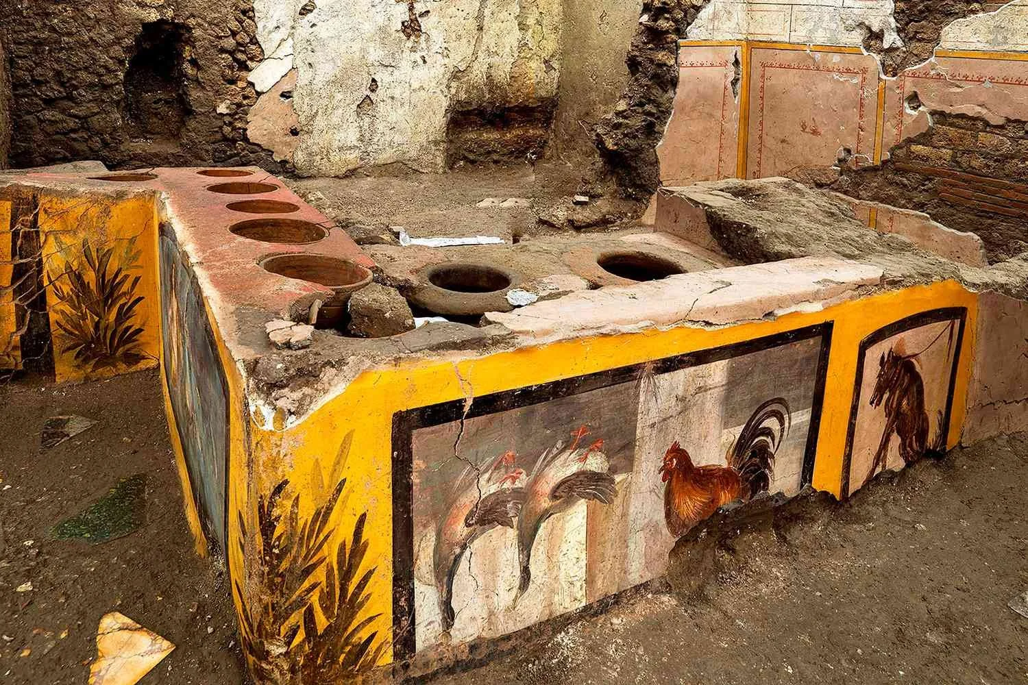
Pompeii was entombed in ash and pumice when the nearby Mount Vesuvius erupted in AD79, killing between 2,000 and 15,000 people. Since its ruins were unearthed in the 16th century, archaeologists have dug up around two-thirds of the site.
Greater Adria, a lost continent hiding in plain sight
Move over, Atlantis. Not all lost continents are myths; here’s one whose existence has just been verified by science. Greater Adria broke off from North Africa 240 million years ago. About 120 million years later, it started sinking beneath Southern Europe. But bits of it remain, scattered across local mountain ranges.

It’s the geological similarities in those mountains that had led scientists to hypothesize the presence of an ancient continent in the Mediterranean. But the region’s geology is so complex that only recent advances in computing—and a 10-year survey by an international team of scientists—were able to produce a geo-historical outline of that former land mass. This is the very first map of the world’s latest lost continent.
The 100-million-year history of Greater Adria starts nearly a quarter of a billion years ago. The world was a very different place back then. It was just recovering from the Permian-Triassic extinction, which came pretty close to wiping out all life on Earth. The planet was repopulated by the first mammals and dinosaurs.
SUPERCONTINENTAL BREAK-UP
Oblivious that biological imperative, Earth’s geology was on a course of its own: fragmentation. At that time, the planet’s land masses had coagulated into a single supercontinent, Pangaea.

Around 240 million years ago, a Greenland-sized piece of continental plate broke off from what would become North Africa and started drifting north. Between 120 and 100 million years ago, the continent smashed into Southern Europe. Even though the speed of that collision was no more than 3 to 4 cm per year, it ended up shattering the 100-km thick crust.
Most of the continental plate was pushed under Southern Europe and swallowed up by Earth’s mantle, a process known as subduction. Seismic waves can still detect the plate, now stuck at a depth of up to 1500 km.
But some of the sedimentary rocks on top were too light to sink, so they were scraped off and got crumpled up—the origin of various mountain chains across the Mediterranean region: the Apennines in Italy, parts of the Alps, and ranges in the Balkans, Greece and Turkey.
DEATH AND BIRTH
Flowing from present to deep past, this time-lapse reconstruction of the geological history of the Mediterranean shows the death and birth (in that order) of Greater Adria in unprecedented amounts of detail.
Some bits of Greater Adria survived both the shave-off into mountainhood and death by subduction. “The only remaining part of this continent is a strip that runs from Turin via the Adriatic Sea to the heel of Italy’s boot,” says Douwe van Hinsbergen, Professor of Global Tectonics and Paleogeography at Utrecht University, and the study’s principal researcher. That’s an area geologists call ‘Adria’, so the team, consisting of scientists from Utrecht, Oslo and Zürich, called the lost continent ‘Greater Adria’.
What was the continent like? A shallow continental shelf in a tropical sea, where sediments were slowly turned into rock, Greater Adria possibly resembled Zealandia, a largely submerged continent with bits sticking out (i.e. New Zealand and New Caledonia), or perhaps the Florida Keys, an archipelago of non-volcanic islands. Either way, dotted with islands and archipelagos above the water, and lots of coral below, it was “probably good for scuba diving,” Van Hinsbergen says.

It took scientists this long to produce the first map of Greater Adria not just because the Mediterranean is, in the words of Van Hinsbergen, “a geological mess (…) Everything is curved, broken and stacked. Compared to this, the Himalayas represent a rather simpler system.” Greater Adria perished by subduction and scraping-off. The Himalayas emerged by the collision of two continents.
ORE DEPOSITS
The region also has a complex geopolitical makeup, obliging the researchers to piece together evidence from 30 different countries, from Spain to Iran, “each with its own geological survey, own maps, own ideas about evolutionary history. Research often stops at national borders.”
So what has geology learned from the discovery of Greater Adria?
First off, that its hypothesis was right: Geological similarities across the Mediterranean really did point to a lost continent, now found.
Secondly, the reconstruction of Greater Adria has also taught geologists that subduction is the basic way in which mountain belts are formed.
They’ve also learned a great deal about volcanism and earthquakes, and “(we) can even predict, to a certain extent, what a given area will look like in the far future,” van Hinsbergen says.
Finally, and practically, these insights will help scientists and surveyors to identify and locate ore deposits and other useful materials in mountain belts.


