In the following video we will be talking about Subutai, who was a Mongol general and the primary military strategist of Genghis Khan. Watch the video to find out more!
What a Medieval Duel Really Looked Like
The magnificent age of knights, bards, and sprawling kingdoms. We focus today on the bloody, messy reality of judicial duels or trials by combat. Among its most renowned practitioners were Jean de Carrouges and Jacques Le Gris of “The Last Duel” fame.
Today, the knights Guy of Steenvoorde and Herman the Iron square off in a savage duel... only one will leave with their manhood intact.
The Brutal Reality of Viking Raids
Viking berserkers rush into a town and villagers scatter. Many are cut down with axes, spears, and arrows. From Lindisfarne to Seville, these lightning raids are unpredictable, brutal, and strategically aimed at vulnerable targets. For many coastal regions, Vikings raids bring an inevitable massacre. Today, we look at how best to survive a Viking raid.
Rare Arabic inscription discovered during construction on the Fgura housing project
The second Arabic inscription to be uncovered outside of Rabat, the discovery is 'very significant and unusual,' according to the Superintendent for Cultural Heritage.
During construction on a communal housing project in Fgura near the Buleben industrial zone, a stone slab with a medieval Arabic inscription was discovered.
The discovery, which sheds light on a largely unexplored time of Maltese history when a sizable portion of the population was Muslim, is being hailed as a landmark finding.

The Arabic inscription was found in a naturally carved well in fields fronting Triq id-Dejma, Triq il-Karmnu and Triq tax-Xemx u l-Qamar, where the Planning Authority recently approved a social housing project
In areas near Triq id-Dejma, Triq il-Karmnu, and Triq tax-Xemx u l-Qamar, where the Planning Authority recently approved a communal housing project, the Arabic inscription was discovered in a naturally carved well.
The stone slab was discovered beside ceramics that predates the 13th century. Numerous silo pits and agricultural trenches were also found at the site as a result of the archaeological assessment.
The historical artifact was described by a representative of the Superintendence for Cultural Heritage as "a limestone prismatic stele, truncated at each end, bearing Arabic script."
The writing is most likely in the Kufic alphabet, which was employed by early Muslims to record the Qur'an. This angular, slow-moving font was frequently used on gravestones, coins, and building inscriptions.
The calligraphic design discovered in Fgura needs to be verified, nevertheless. Other markings on the slab "may represent symbols rather than writing" are also visible.
When Sir Temi Zammit began excavating the Roman Domus outside of Mdina in the early 20th century, he found an Arab cemetery that had been constructed on top of the Domus' ruins. This artifact is typologically quite similar to a number of stelae that were also found there.
This is the only other copy known to have been discovered outside of Rabat, with the exception of another one discovered at Savina Square in Victoria in 1901, "making this discovery very significant and rare, both archaeologically as well as historically," according to the SCH.
An Arabic language specialist from the University of Malta is working with the Superintendence to help decode the inscription, which is thought to be crucial for establishing the object's original usage and providing precise dating.
The inscription was discovered inside an approximately 8.5-meter-deep vertical natural fissure that had been partially constructed into a well.
According to the SCH's investigations, the inscription and other items discovered in the well may have been "dumped there" at a later time. It is a sign that the inscription was discovered somewhere other than its original location. However, despite the absence of modern materials, the site is still regarded as offering a reliable archaeological context.
Additionally, pottery from the same site, which dates to no later than the 13th century AD, places the location to the Medieval era.
Plans for the development's basement and ground floor levels were altered as a result of the big archaeological discovery so that the more noteworthy features will be preserved and made always visible. The communal housing project includes a reservoir, a basement with 66 garages on two levels, and 117 above-ground housing units arranged over five levels.
All artifacts have been located and are being kept in the repository and laboratory of the Superintendence for the required conservation and examination.
The Superintendence has also recently made reference to the archaeological potential of an adjacent 23,468 square meter property that is just 108 meters away and planned for residential construction by developer Anton Camilleri. The SCH states that any development on this property that is allowed should be subject to "archaeological monitoring."
Reminiscences of Muslim Malta
Despite the fact that Malta was under Arab rule from 870 AD until the Norman conquest in 1091, a sizeable portion of the population continued to be Muslim and coexisted alongside Jewish and Christian communities. The Norman era is when the majority of the archaeological evidence for a Muslim presence in Malta, including the Muslim cemetery in Rabat, was discovered. The Maimuna stone, which is currently on display at the Gozo Archaeology Museum, is likewise from 1174.
The memorial prayer on the stone is written in Kufic script and is addressed to a young Muslim woman by the name of Maimnah. Verse from the Qur'an that discuss death are also included. However, the precise location of the stone's discovery is unknown, despite the fact that it is widely believed to have been between the Gozitan villages of Xewkija and Sannat in a region known as Ta' Majmuna.
Giliberto Abate recorded 836 Muslim homes, 250 Christian households, and 33 Jewish households in Malta and Gozo in his report from 1240.
Only 47 Christian houses in Malta and 203 in Gozo are mentioned in the record. The figures demonstrate the persistence of a sizable Muslim community even as late as 1240, even though it's likely that they only apply to a section of the island's population or that a 'M' standing for a 'thousand' was accidentally dropped in front of Malta's Christian population.

Ibn Haldun claims that in 1249, Emperor Frederick II banished the Muslims of Malta along with the Muslims of Sicily, who are known to have been exiled to Lucera in Sicily based on other evidence. But it's likely that accepting formal baptism was all the Muslims needed to do to avoid expulsion.
The late Godfrey Wettinger claimed that this accounted for the Maltese language's survival "largely in the form it had taken during the centuries of Muslim hegemony" despite the continuous influx of settlers from Europe, notably churchmen and merchants, into the islands. Words associated with Muslim religious practices have survived as a result of this. For instance, Ramadan, the Islamic holy month of sacrifice and fasting, is whence the Maltese word Randan (Lent) originates. Similar to how Easter has its roots in the jubilant Islamic feast of Eid al-Fitr, which celebrates the conclusion of Ramadan.
Additionally, Friday is known as "Il-imga" in Maltese since it is the day when Muslims on the island used to gather for their weekly congregational prayers, or "Jumu'ah." Additionally, the Maltese refer to their God as Alla, which is derived from Allah, just like Muslim and Christian Arabs do.
Huntsman-gatherers fit into southern Africa's first metropolis, according to archaeology, 800 years ago.
There is a hill that hardly stands out from the others where the Limpopo and Shashe Rivers converge to form the current border between Botswana, South Africa, and Zimbabwe. Without realizing its historical significance, one could simply pass it. Around 800 years ago, Mapungubwe, what appears to be the earliest state-level society and urban center in southern Africa, first emerged on and around this hill.

Archaeologists excavate inside and outside Little Muck Shelter, in the Mapungubwe National Park, South Africa. Photo: Tim Forssman
We now know quite a bit about this ancient kingdom, how it developed amid early farmer culture, and its participation in international trade networks after nearly a century of research. Before farmers arrived, hunter-gatherer communities lived on this land, but they have received little recognition despite what appears to be their role in the rise of the Mapungubwe.
In an effort to provide a more inclusive portrayal of the region's past, our team has been doing research in northern South Africa at locations that we hope would enable us to recognize the roles performed by hunter-gatherers during the creation of the Mapungubwe state.
Little Muck Shelter is the name of our main research location. It is located around 4 kilometers south of the Limpopo River in the Mapungubwe National Park. The shelter is a sizeable structure with a huge open area in front and a covered area beneath a high roof. Additionally, it contains numerous paintings on the walls, including exquisite images of giraffes, kudu, cats, and elephants. Hunter-gatherer people created this art, which is typically understood to alludes to the spirit world and the actions of shamans there.

Two beautifully painted giraffe are at the centre of the site in orange and red. These have been traced using digital software to limit contact with the art which may lead to damage.
The findings of our study indicate two things. Prior to the Mapungubwe Kingdom's establishment, the region was inhabited by hunter-gatherers. Second, they had access to the riches that helped elite groups appear in society at the time because they were a part of the economy at the time. while taken together, these facts demonstrate that hunter-gatherer societies must be considered while thinking about the history of Mapungubwe. They participated in and were present for these important events.
Why is this crucial? The building up of wealth was one of the key events that contributed to the creation of the Mapungubwe Kingdom. It influenced the emergence of social hierarchies and established status. These valuable trade commodities were typically possessed by affluent social classes. However, hunter-gatherers were able to acquire comparable goods at a period when these products were helping to significantly alter society by utilizing their own skills. The fact that they had access to riches during this time certainly demonstrates how highly valued their contributions to local society and how deeply ingrained they were in the community's economy.
Unearthing evidence of trade
We were drawn to Little Muck Shelter because of earlier research conducted there in the late 1990s, which revealed that farmers and hunter-gatherers conducted extensive commerce from the shelter. We needed a larger archaeological assemblage to confirm or modify our theories in order to comprehend this better.

Field team member Siphesihle Kuhlase shows a broken bangle while others remove deposit in search of artefacts.
In order to clearly demonstrate a hunter-gatherer presence throughout this time, as well as their involvement in regional commercial networks, we also sought to more extensively analyze the depths that dated between AD 900 and 1300, during which the events leading to Mapungubwe began and finally finished.
We had to dig to do this. During an archaeological excavation, layers of sediments containing artifacts are carefully removed while adhering to very rigorous depth and position controls within an excavation trench.
This is followed by a protracted period of analysis that follows strict standards to guarantee consistency in classifying artefact kinds, their production processes or methods, how they were utilized, and what materials they were composed of.
After that, we put all this information together in an effort to comprehend earlier lifestyles. Our findings allowed us to reconstruct a hunter-gatherer history that was interwoven with the development of the Mapungubwe.
First and foremost, we had to demonstrate that there were still hunter-gatherers in the area at the time Mapungubwe first arose. We have evaluated over 15,000 stone tools from a sampling of our excavations so far, and we have discovered a set of finished tools that are identical to those made by hunter-gatherers for thousands of years before farmer communities arose. We think that the continuity of cultural material over such a long period of time demonstrates unequivocally that hunters and gatherers inhabited the shelter while farmers were present.

A range of artefact types found at hunter-gatherer sites like Little Muck Shelter. Stone scrapers (A) and backed tools (B), which were used for producing goods and hunting, respectively, glass beads (C), traded into central Africa from the east African coastline, and larger ostrich eggshell beads (D), bone points or needles (E), broken pieces of copper jewellery (F) and pottery (G), and a grooved stone used to either sharpen metal tools, round ostrich eggshell beads, or finish and polish bone tools (H). Tim Forssman
Next, we wanted to focus on the trading economy in more detail. Beginning in the early first millennium AD, hunter-gatherers changed their craft practices as soon as farmer groups arrived in the area. Up to the fall of the Mapungubwe Kingdom in AD 1300, they mostly produced bone implements rather than products made from hide, wood, and shell. This implies that contacts between farmers and hunter-gatherers from the time of their initial arrival sparked change in their produced goods.
Why did they alter their creative endeavors? We observed the emergence of trade wealth during these transformations, initially in the form of ceramics and glass beads, and later in the form of metal. These items are typical at farmer towns and were never produced by hunter-gatherers, indicating trade between these two societies. It suggests that hunter-gatherers emphasized their own skill sets in response to emerging market opportunities.
We're still looking for more proof that hunter-gatherers participated in these processes. We want to know what other activities they participated in and whether they themselves created a more sophisticated society.
'Unique' artwork are found in a crypt-like place in Sudan through a hole in the earth. Look inside
The remnants of a once-thriving city were scattered around a small chamber that was concealed beneath the northern Sudanese desert. The room was covered with portraits of well-known people, but there were more questions than answers there.

Archaeologists excavating centuries-old houses in Old Dongola found a hole leading to complex with “unique” Christian paintings, photos show. Photo from the UMMA Archaeological Project in Old Dongola and the Polish Centre of Mediterranean Archaeology at the University of Warsaw
During excavations at Old Dongola, a millennia-old city on the bank of the Nile river in northern Sudan, the chamber was discovered. According to the Polish Centre of Mediterranean Archaeology at the University of Warsaw, the urban ruins served as the capital city of the Makurian kingdom from the fifth to the fourteenth centuries.
According to scholars, the city grew under the Makurian monarchs and became a significant urban and Christian religious center. The Makurian monarchs constructed a gigantic castle, a royal palace, multi-story residences, pottery studios, churches, and a sizable structure that may have served as a throne hall.
Old Dongola merged with the Muslim Sultanate of Funj in the 15th century after the monarchs' rule came to an end. Researchers claim that 300 years later, the city was abandoned.
According to a press statement issued on April 5 by the Polish Centre of Mediterranean Archaeology at the University of Warsaw, archaeologists were looking through houses from the city's Funj period when they discovered an aperture under a floor. This tiny opening is visible in Facebook photos.

An archaeologists works to preserve the paintings in the underground chamber. Photo from the Polish Centre of Mediterranean Archaeology at the University of Warsaw
As stated in the press release, after crawling down the hole, researchers discovered a small, bricked-up structure that was painted on. The ages-old room was a "surprise" discovery, according to archaeologists.
Three "unique" wall murals depicting Christian motifs were found in the little room, according to the press release.
A artwork "of the Virgin Mary" was found on one of the chamber's side walls, according to researchers. Photos depict a woman carrying a book and a crucifix while dressed in black robes. She has a halo of bright yellow around her head.

Painting of the Virgin Mary on the side wall of the chamber. Photo from the Polish Centre of Mediterranean Archaeology at the University of Warsaw
According to experts, this picture does not represent "Mary in Nubian art" in a "typical" manner.
According to the press statement, there was a painting of Jesus Christ on the other side wall. The man person is holding a book in one hand. The other hand he uses to make "a gesture of blessing," according to the study.
Experts noted that the central painting was likewise unusual. The central character, a Makurian ruler, is seen bowing to Jesus and kissing his hand. The figure on the right is Jesus, who is perched on a cloud. The announcement stated that the left-hand figure represents the archangel Michael, who spreads his wings around the group and supports the king.
A scenario with this "dynamism and intimacy" "finds no parallels in Nubian painting," according to specialists.
An Old Nubian inscription can also be seen on the main artwork. The inscription cites a Makurian "king named David and a plea to God for protection of the city," most likely the city of Dongola, according to Vincent van Gerven Oei, an authority on this language.

The center painting showing the Makurian king David (center) bowing to Jesus (right) with the support of the archangel Michael (left). Photo from the Polish Centre of Mediterranean Archaeology at the University of Warsaw
One of the final kings of Christian Makuria, Makurian King David "marked the beginning of the end of the kingdom," according to historians. He spearheaded an assault on Egypt, which in retaliation took control of Dongola.
The relationship between these historical occurrences and the artworks is still a mystery to specialists. These paintings' age and whether they date from before or after King David's reign are unknown to archaeologists.
According to the release, the subterranean room might also be connected to a nearby collection of ruins. According to academics, the neighboring ruins are those of "the Great Church of Jesus," which was likely Dongola's cathedral and the most significant church in the Makurian empire.
However, the chamber still has many unanswered questions. In the fall, research at Old Dongola will continue.
The distance between Old Dongola and Khartoum, the Sudanese capital, is around 260 kilometres.

Mykonos, Greece: The unacceptable "Mafia" attack on the archaeologist M. Psarros
Mykonos, one of Greece's most famous and cosmopolitan islands that is also subject to urban planning and other arbitrary decisions, is well known for many things, but not nearly as much as it should be for its rich history and antiquities, which have undoubtedly not been updated in the most appropriate manner.
Although the island has significant archaeological sites and finds dating from the Neolithic to the Middle Ages and Modern Times, which are undeniable examples of its long history and uninterrupted human presence on its territory, its archaeology is relatively unknown to the general public and has been that way until recently. This is due to the struggle of the archaeologists who work there to highlight, maintain, and "defend" its antiquities from the uncontrolled development and tourism.
It took the shocking, mafia-style attack on the island's archaeologist in charge, Manolis Psarros, on 7/3 in Athens, for all this to make the news, and may there be, albeit belatedly, a firm stance by the state so that the perpetrators are found and such unacceptable phenomena that tarnish the image of the place are not repeated (the case has since been taken over by the Extortion Prosecution Department).

Manolis Psarros has been working in Mykonos since 2014. No, he never received threats in the past, he says, nor was there any "warning" about the brutal attack that cost him, among other things, three broken ribs. "There are a number of contractors on the island who build illegally at night, but most architectural firms fully comply with the law".
Thirteen new archaeological sites, ten of which are within the designated sites, have been found on Mykonos in recent years, he claimed, adding to the 37 that his predecessor, Panagiotis Hatzidakis, had already designated as sites and monuments based on the oldest archaeological research on the island.
Mykonos, which currently employs three archaeologists, could get its own Ephorate of Antiquities, Manolis Psarros continued, "Understaffing is another problem that the sector is facing, and not only with regard to us archaeologists. For example, some time ago two staff members left, and now we are forced to take over archiving, among other things. Another constant demand of ours, which affects not only the Archaeological Museum of Mykonos but most museums in the country, is the creation of efficient storage spaces and organized laboratories. Otherwise, all this knowledge stagnates and cannot go out into the world.".
Mr. Psarros is requesting a guarantee from the government and police for his protection as well as the safety of his coworkers because he has not been intimidated by the incident and wants to carry on working on the island. "We formed a fist-like formation as a result of the community's touching support. Yet, the Minister of Culture's remarks caused more rifts than they healed. The aggravated assault charge against the attack's perpetrators was the only thing that could be considered positive "He'll say it.
"Mykonos may have been in the shadow of Delos, the great religious, economic and cultural center of the Aegean in antiquity, but it was nevertheless directly related to it, while itself preserving an important historical reserve," says the curator of Cycladic antiquities, Mr. Athanasoulis.

"In Mykonos we have one of the oldest Neolithic settlements on the beach of Ftelia, the Proto-Cycladic settlement of Diakoftis, the Mycenaean vaulted tomb of Angelika, which yielded remarkable finds, but also the ancient cities in the castle of Chora, in Paraportiani, and in Paleokastro, in Ano Mera, which are now being excavated and studied more systematically. The excavations in the Castle of Chora have already uncovered the entire Venetian residential structure. Among them we found the ruins of the Byzantine castle and among them finds from classical and prehistoric Mykonos, revealing the timelessness of one of the most remarkable archaeological sites in the Aegean."
“Other important sites involve rural places from the Hellenistic period and not only examples of the rural character that the landscape of Mykonos had for many centuries, towers, but also remarkable Byzantine churches”, he continues. The island was in its heyday at the classical period too, from which we also have remarkable finds, with the capital located on the site of the present Chora. Among the most important archaeological finds are the Neolithic clay figure found in Ftelia and a large pithos from the 7th century BC, depicting scenes from the fall of Troy.

"Currently, the only archaeological site that is highlighted is the castle of Chora. The part that was highlighted is now one of the attractions of the island and is visited by many visitors. Another such place is Paleokastro, which is also timeless. This year we have carried out excavations there, where the remains of an older settlement were found. The Neolithic settlement of Ftelia is preserved in remarkably good condition, but both the masonry and the ruins found there are very fragile, so they can hardly be visited. It seems that the best solution to save it is to "return" it to the ground, because only in this way can it be effectively protected," he says.
The oldest museum in the Aegean, the Archaeological Museum of Mykonos, was constructed between 1900 and 1902 on Kamnaki Point, above the historic harbor. Since then, it has housed the extensive artifacts from the "Purification Pit" from the fifth century BC that was unearthed in 1898 on the nearby island of Rhenia, as well as artifacts from Delos and other island graves. The Ministry of National Education and Religious Affairs and the Archaeological Society of Athens shared the expense of the design by architect Alexandros Lykakis. The original neoclassical structure was given its current form in 1934, and the big eastern hall was erected in 1972 on land that was provided by the Municipality of Mykonos.
The museum displays a large number of vases from prehistoric to late Hellenistic times (mid-3rd millennium-1st century BC), funerary statues, columns and urns from the Rhenia and some Myconian vases. The collections include funerary statues and columns from the 2nd to 1st centuries BC, vases from the middle of the 3rd millennium BC - 1st century BC, figurines from the 2nd to 1st centuries BC, jewellery and small objects of the 2nd to 1st centuries B.C.E. In recent years, major exhibitions have been held there ("Vanity", "From the world of Homer: The Mycenaean Cyclades", "The Palace at 4 a.m.", "The Archipelago is on Fire").

What transpires, however, when significant archaeological sites are situated in exceptionally well-liked tourist locations, when active excavations are close to well-known resorts? A considerable encroachment on the land is caused by the strong expansion of tourism, which is accompanied by extensive construction activity. An undesirable side effect of the excavations required for the construction of all these buildings is the significant disruption of the natural environment and scenery caused by legal and arbitrary constructions, which in the case of Mykonos has sadly reached a tremendous extent. In addition to being particularly beautiful, this landscape is a crucial component of the historical setting. The antiques unearthed there are lost along with the environment. The attack on Mr. Psarros is not related to any particular archaeological site or excavation, but it is an unacceptable act which should be brought to justice so that the culprits are also found and there are no more such incidents," says Mr. Athanasoulis.
The new archaeological sites of Mykonos
A "summary" of the archaeological map of the island after the excavations and researches of 2015-2019, as mentioned in a preliminary publication by archaeologists Manolis Psarros, Dimitris Athanasoulis, Maria Koniotis and Angeliki Koumnas.
At the site of Diakoftis, the remains of the first known Proto-Cycladic settlement of Mykonos were found and excavated. Fragments of mounds, pithoid vessels, bottles, sherds, stone cutters, worked obsidian blades, sketchy marble figurines, bronze forks and two ceramic hearths were found.
On the Haranou site, three large retaining walls were found during the construction of the new Mykonos substation, built according to the polygonal grid system that delimited the cultivation fields. On a higher plateau, excavations for cultivation and two large basins carved into the natural rock were found.
At the Aleomandra site, a rural site was identified and an underground water pump tank with a descent scale was exposed.

At the Vrysi-Aggelika site, a stream channel was discovered in connection with the construction of a conference center, dating from the Late Classic to Hellenistic periods and carved into the rock. Its imaginary course is said to approach the valley of Haranou and the archaeological sites of the Mycenaean vault tomb and Akrotiraki.
At Ornos, excavations revealed three areas of a building complex dating from the Late Classical to Roman periods.
At the Masouras site, a ceramic layer and a rectangular space were discovered between the natural rock. The layer yielded a large number of storage vessels, Hellenistic scyphos and about 20 bronze nails.
In Kardamida, architectural remains from Late Antiquity were discovered near the proclaimed sites of Koukoulos and Pyrgos. Among the finds, an intact microlithic vase and parts of trade and storage vessels stand out. It is a rural site from the Hellenistic to Late Roman periods.
Three areas of a large Late Roman building with strong walls, which probably served as a bath, were discovered at Three Pigadia of Chora.
In Panachra, masonry and carvings of various buildings, the dating of which is still under investigation, were found, as well as six bronze wine jars from the early Byzantine period.
In a 19th-century neoclassical building in Little Venice, an older construction phase was found with a cistern and a pebble floor related to the medieval castle house, and even remains of an ancient construction.
In Gialos of Mykonos Town and in the temple of Agios Nikolaos of Kadena, part of the old breakwater to the north, part of the old promenade of Gialos and the complete outline of a shaped islet where an older church was located have been identified, as well as traces of the foundation of a Venetian bridge pier to the east, which can still be seen in photographs at the end of the 19th century to join the waterfront with the islet of Agios Nikolaos.
In addition, the medieval heritage of Mykonos is constantly expanding. In addition to the already known Byzantine churches Panagia of Kouz, Agia Marina or Fragkoklissia in Leno, from the late Byzantine period are also Agios Basilios in Drafaki, Rhodo Amaranto next to the Archeological Museum and Panagia Hosti in Paspari, while a special place is occupied by the Evangelistria in Klouvas.
Archaeologists Discover First Ancient African/Asian
In East Africa, archaeologists have been uncovering the ancient Swahili Civilization, which was a prosperous trading state along the coast of East Africa dating back to the 7th century. For 40 years, University of South Florida anthropologist Chapurukha Kusimba has been dedicated to studying the ancestry of those who built the civilization and restoring their heritage. Kusimba's life's work has been to recover the past of the Swahili and restore them to rightful citizenship. He worked alongside Harvard geneticists David Reich and Esther Brielle and corresponding authors, Jeff Fleisher from Rice University and Stephanie Wynne-Jones from the University of York, to uncover the DNA of 80 individuals from as long as 800 years ago, making it the first ancient DNA uncovered from the Swahili Civilization. Today we will be uncovering one of the first African civilizations with archaeologists.
10 Amazing Discoveries in Egypt That Scare Scientists
New discoveries like these ancient discoveries allow scientists to learn more about history. Some of the discoveries on this list include archeological discoveries as well as unexplained discoveries.
Ancient Egyptian Music - Tomb of the Ancients
In this video we will be exploring Ancient Egyptian music about pyramids, pharaohs, dark tombs, and other things related to Egypt. Enjoy!
Historical Figures Brought To Life (Jesus, Confucius, Louis XIV, Olive Oatman, Mary Snowden)
The photos in this video have been digitally manipulated and brought to life using AI technology. Images have been enhanced, colorized and facial motion added (including smiling, ageing etc.), using AI tools. This video is part of a series where historical figures are brought to life using AI technology. Please note, AI generated portraits may not be historically accurate.
Legendary City Sits At The Core Of The Earth
In the following video we will be talking about the legendary city that sits at the core of the Earth. Watch the video to find out more!
Scoreboard from an ancient Maya ball game played in 894 CE found
At the well-known site of Chichén Itzá in southern Mexico, a stone disk depicting an old Maya ball game was discovered. The game, commonly referred to as "pelota" (literally, "ball"), is said to have been extremely important to the social and political life of the Maya Empire, and archaeologists believe that the artifact may be a memorial to a match that took place more than 1,100 years ago.

The artifact is a rare example of a complete Maya text
The engraving on the object, known as the Disk of the Pelota Players, features two figures dressed in traditional pelota attire and is bordered by a band of glyphic writing. Researchers discovered a reference to a Maya calendar date that corresponds to the year 894 CE within the inscription.
The relic, which is 32.5 centimeters (12.8 inches) in diameter and weighs 40 kilograms (88.2 pounds), was discovered inside of a building known as the Casa Colorada (Colorful House). The complex, also known as Chichanchob, was named after its red-painted interiors and had a pelota court.
According to an announcement made by Mexico's National Institute of Anthropology and History, archaeologist Francisco Pérez Ruiz, "it's rare to find hieroglyphic writing at this site, and even rarer to find a whole book" (INAH). "Eleven years have passed since that incident."
The disk most likely dates to the Terminal Classic or Early Postclassic Maya era based on the date indicated in the inscription. Pérez Ruiz asserts that the painting likely commemorated a significant pelota contest that was taking place at the Casa Colorada at the time.
The individual on the left is wearing a feathered headdress and a ribbon with a flower-shaped motif, most likely a water lily, according to archaeologist Santiago Alberto Sobrino Fernández who described the etched artwork. A scroll, which could be read as breath or voice, is directly below the face.
"The opposing player is donning a "snake turban," a headpiece that has frequently been seen at Chichén Itzá. To play pelota, the person dons protective clothes.
Although additional analysis of the inscription may shed light on both the nature of the match and the final score, neither the identity of the participants memorialized on the disk nor the result of the game are known.
The Yucatan Peninsula is home to Chichén Itzá, one of the biggest Maya towns. The location has a central pelota court that is considerably larger than that at the Casa Colorada, and it is believed that many matches were played there when it was at its busiest.
Players in pelota often propelled a rubber ball with their hip, elbow, or knee. Experts think the game had symbolic meaning, and earlier research revealed that some pelota balls may have even contained the ashes of deceased Mayan emperors.
Found beneath the House of Lords: a 200-year-old fish
A 200-year-old bone that had been carved into the shape of a fish was found during inspections conducted in advance of the Palace of Westminster's restoration.
Perhaps employed in 18th-century card games, the fish was discovered by Roland Tillyer, a senior geoarchaeologist at the Museum of London Archaeology, while he watched a borehole being dug deep beneath the Royal Court of the House of Lords.

"This carved bone fish is a gaming counter," stated Michael Marshall, the MOLA Finds Team Leader. Such counters were frequently employed as scoring tokens at gaming tables in Britain during the 18th and 19th centuries.
Lydia Bennet is depicted as winning and losing fish while playing games of "lottery tickets" in Jane Austen's Pride and Prejudice (first published in 1813), which is considered one of the most famous literary descriptions of this behavior.
Almost 7,500 hours of specialized intrusive and disruptive surveying work have been accomplished since survey work began in July 2022. In addition to the tens of thousands of hours of planning and visual inspection study finished since 2018, this work will help guide decisions on the historic Palace of Westminster's restoration.
In addition, the location of concealed voids that were originally built as ventilation shafts, the state of vital utilities, a sampling of the building materials, and outdated heating, cooling, mechanical, and electrical systems were all discovered during the construction.
The discovery comes after a portion of the original medieval Thames River wall that was thought to extend beneath the length of the Houses of Parliament may have been found in November 2022.
"We'll take the important data from this extensive research to inform our future restoration plans for the building, ensuring that we tackle critical issues and preserve and protect the building and the thousands of staff and visitors who use the building every day," said David Goldstone, CEO of the Houses of Parliament Restoration and Renewal Delivery Authority.
An undisturbed tomb in Italy has a 2,500-year-old last meal. Today, people still like it.
According to local media sources, a 2,500-year-old tomb in Italy was recently discovered with a rare last meal remaining within.

A 2,500-year-old Etruscan tomb was recently excavated in Italy, according to local media reports. It contained a rare last meal.
A news release from the Parco di Vulci, an archaeological site, on April 4 stated that the tomb, which was found around 70 miles northwest of Rome, was constructed by the mysterious Etruscan civilisation, which lived on the Italian peninsula before the Romans.
As reported by the Italian news site GreenMe, the necropolis had been unaltered since it was built in the sixth century B.C. and was surrounded by massive stone slabs.
Archaeologists were reportedly speechless when they discovered the centuries-old burial chamber, according to GreenMe.
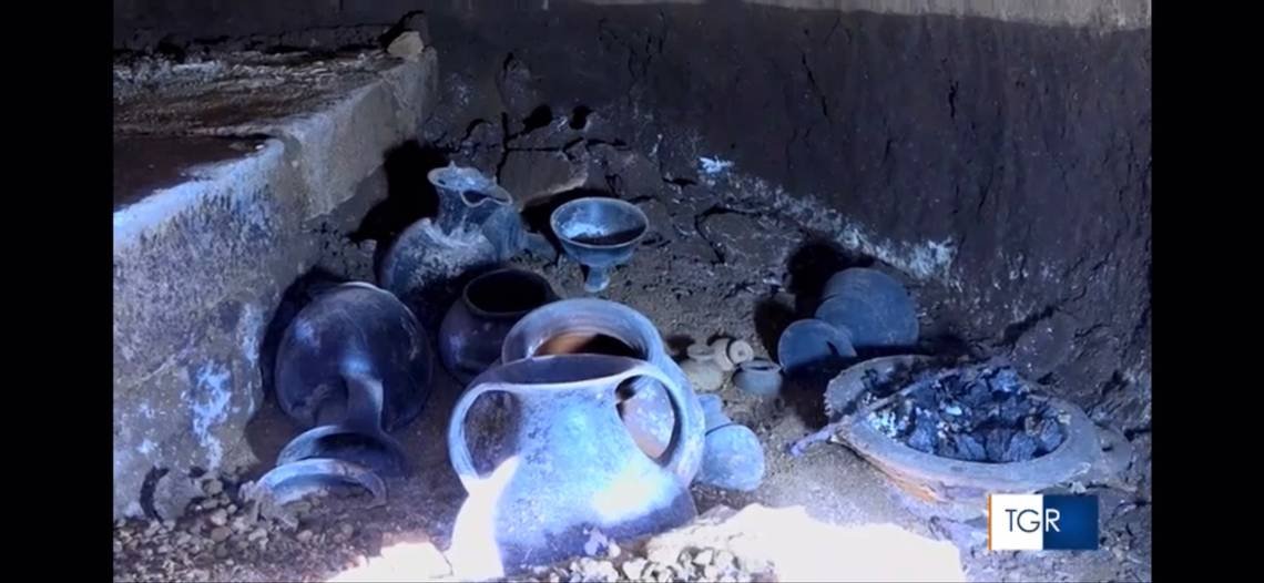
Upon excavating the ancient tomb, archaeologists found pottery and a brazier.
The existence of a weaving tool and a piece of pottery leads the park to believe that it belonged to a lady.
The remains of a final meal were also discovered within the tomb, which was a rare and extraordinary discovery, according to the Italian news source TGR.
According to TGR, a bronze brazier, or cooking pan, included coals and a spit. The tools would have been utilized to skewer meat.
According to the site, a laboratory will conduct an analysis on the recently discovered artifacts.

Coals in a brazier and a skewer constituted the remains of the last meal, archaeologists said
A 2013 study in the French journal Anthropozoologica suggested that animal remains previously found in an Etruscan tomb might have been part of a ritual offering known as "meal of the dead."
The Smithsonian Magazine claims that the Romans vanquished the clever Etruscans in the third century B.C. They were a people with a mysterious language and a disputed origin. Their culture had a profound impact on Roman and Greek culture.
Outlander's Craigh na Dun was inspired by these 13 enigmatic standing stones and rings in Scotland
Standing stones are ancient buildings claimed to have been built by the country's early settlers thousands of years ago. They may be found all around Scotland, but are particularly prevalent in Orkney and Shetland. Yet, to the ordinary Outlander fan, their purpose is as obvious as day: time travel. Historians and archaeologists continue to argue their significance today and believe they were religious places.
We don't fully understand these standing stones, just like we don't fully understand many other aspects of ancient civilizations like the Picts or Nordic settlers. As a result, we are left to make educated guesses, but what is certain is that they serve as magnificent monuments that are well worth a visit.
Let these 13 standing stones and stone circles in Scotland help you travel through time to a time thousands of years ago.
1. Calanais Standing Stones

The standing stones at Calanais, Scotland's most well-known stone circle, are believed to have been constructed around 4,500 years ago during the late Neolithic period. Thirteen stones make up the circle, and a monolith is located not far from the center.
2. Ring of Brodgar

One of the best stone circles in the UK is Brodgar, which was given UNESCO World Heritage Status in 1999. Its exact age is unknown, although experts estimate it to be at least 4,000 years old.
3. Machrie Moor Standing Stones

Six concentric stone circles make up Machrie Moor, which is located on a moor not far from Arran's west coast. Machrie Moor is estimated to have existed circa 2030 BC based on carbon dating of the site's remaining timber.
4. Clava Cairns

While none are known as Craigh Na Dun, you can discover the site that served as the inspiration for the Outlander setting among the numerous standing stones and circles that are dispersed across Inverness. According to Historic Environment Scotland, the Clava Cairns were constructed to lodge the dead and are located in a wooded area east of Inverness, close to Culloden. For millennia, the cemetery was considered a holy site in the landscape.
5. Standing Stones of Stenness

Stenness, which lies less than a mile southeast of the Ring of Brodgar, is considered to be the UK's oldest henge site. Pottery found there connects it to the prehistoric community at Skara Brae. The Stones of Stenness, which were constructed about 5,400 years ago, may be the earliest henge monument in the British Isles, according to Historic Environment Scotland.
6. Balfarg Henge

Balfarg is made up of two standing stones that were once a component of an inner circle inside the henge. It was discovered in the late 1970s during the construction of a new housing complex. At the site, archaeologists found ceramic fragments that date back about 5000 years. Nonetheless, according to certain estimates, some of the construction is closer to 6000 years old.
7. Aberlemno Pictish Stones

Four stones in the settlement of Aberlemno have Pictish sculptures that date from between AD 500 and 800. The Picts were prehistoric Celts who inhabited what is now known as eastern and northeastern Scotland. The better of the three roadside stones in Aberlemno has fine snake, double-disc and z-rod, mirror, and comb symbols, according to the Aberlemno Organization. The third stone is a Pictish cross slab that features an excellent hunting scene on the back and a ring cross on the front.
8. Tomnaverie Stone Circle

The unique type of recumbent stone circle found alone in north-east Scotland is Tomnaverie. It is located in Aberdeenshire, about a mile from Tarland village, on a hilltop. According to experts, a 4,500-year-old burial cairn is encircled by the stone circle.
9. Temple Wood Stone Circle

One of the stone circles in Kilmartin Glen that is thought to be in the best condition is located in this lovely area. The stone circle is thought to have been in use beginning from 3000 BC and continuing up until 1000 BC.
10. Laggangairn Standing Stones

It is said that these two stones are the last two remains of a monument that formerly had 14 stones (in 1873 you could still find seven standing). They have allegedly been present in the New Luce region for up to 4,000 years. Christian crosses with symbolism assumed to date from 600 to 800 AD are etched on the stones.
11. Achavanich Standing Stones

In Caithness, close to Loch Stemster, are the Achavanich stones. Although the bulk of the stones are very modest, it is believed that they weren't always like way. The tallest stone is about 2 meters tall. Their size has degraded due to weathering over time. Furthermore, even though there are only 36 stones left today, there may have once been 54.
12. Tuilyies Standing Stones

The word "Tuilyies," which refers to a fight in Scots, was used to describe the standing stones. Three more sizable stones are located close to Dunfermline, but the most notable stone is an oddly shaped megalith. The "Tuilyies Stane" is the name of the megalith or major stone.
13. Cullerlie Stone Circle

Due to their close vicinity to the village of the same name, Cullerlie is also known as the Standing Stone of Echt. It is made up of eight uneven but beautifully aligned red granite stones surrounded by an equal number of tiny cairns. According to Historic Environment Scotland, the building is 4000 years old.
Istanbul finds underground passageway dating back 1,500 years
During the ongoing excavations under the ruins of Saint Polyeuktos Church in Istanbul's Saraçhane neighborhood, which was destroyed during the Latin invasion, a 1,500-year-old underground passage has been discovered.
On June 8 2022, the teams from Istanbul Municipality's Cultural Heritage Department began digging in the vicinity of the church.

The excavation teams discovered a subterranean passageway during ongoing construction that is 1,500 years old. The building stones of the hallway were formed from marble and decorated with reliefs.
According to Mahir Polat, deputy secretary general of the municipality, the building is a model for staying strong and undamaged despite the tremors that Istanbul experienced throughout the years.
What is one of the most significant elements of this 1,500-year-old passage's discovery? In these 1,500 years, Istanbul, which is currently at risk for earthquakes, has experienced dozens of shocks. This building has been able to withstand all of these earthquakes. Türkiye should understand this and discover the secret, according to Polat.
Polat noted that scientific consultants and civil engineers with expertise in earthquakes had also helped with the municipality's excavation projects and that the experts will also release a report outlining the earthquakes the region had previously experienced.
According to Polat, the location of the church from 524 is crucial for urban archaeology since ongoing excavations may uncover previously undiscovered historical information about the city.
"We just finished a project that will turn it from a run-down location where homeless people stay and where all types of criminality occur into a tourism place within 10 months," Polat added.
After the site is opened to visitors, archaeological excavations will still be taking place, giving locals in Istanbul the chance to learn more about archaeology, according to Polat.
We'll conduct simultaneous excavations while visitors are there. Also, we will be able to use that to demonstrate the significance of the historical structure, he added.
A statue that is believed to date back to the Roman era and is almost 1,900 years old was recently found in the same location by a team from the municipality.
In addition to the statue, the excavation workers in the region also discovered 681 bronze coins, stamped bricks, marble fragments, ceramics, oil lamps, glass, and metal objects.

Becoming a Member of Parliament in Ancient Athens: Criteria and Qualifications
Ancient Athens is often regarded as the cradle of democracy, with its unique political system paving the way for modern democratic practices. The city-state's governing body was the Ekklesia (Assembly), which comprised adult male citizens who participated in decision-making processes. However, to become a member of the Boule (Council), which functioned as a sort of parliament, certain criteria and qualifications had to be met. This article delves into the requirements for an Athenian to become a member of this prestigious institution.

Citizenship
The first and foremost requirement to become a member of the Boule in ancient Athens was citizenship. Only Athenian citizens enjoyed political rights, which allowed them to participate in the Assembly and be eligible for the Council. Citizenship was typically inherited, and an individual had to be born to Athenian parents to claim this status. Citizenship could also be granted as an honor to foreigners for exceptional service to Athens, but this was a rare occurrence.

Age
To become a member of the Boule, an Athenian had to be at least 30 years old. This age requirement was in place to ensure that only mature and experienced individuals would serve in such an important role. In addition, Athenians believed that individuals who had reached the age of 30 would have more wisdom and better judgment than their younger counterparts.
Property and economic status

Though ancient Athens was a democracy, not everyone enjoyed equal access to political power. To be eligible for the Boule, an individual had to possess a certain amount of wealth or property. This requirement ensured that council members were financially stable and capable of supporting themselves during their time in office. However, it also served to maintain the influence of the wealthier classes in Athenian politics.
Lottery system
Unlike modern political systems where candidates are elected based on merit or popularity, members of the Boule in ancient Athens were chosen by a lottery system. This process was designed to ensure that the council's composition was representative of the entire Athenian citizen population. Every year, 500 members were selected from the ten tribes of Athens, with 50 members representing each tribe.
Morality and integrity
A prospective member of the Boule was expected to possess good moral character and integrity. Before being allowed to serve on the council, a candidate had to undergo a process called "dokimasia," which was a thorough examination of their background and character. This procedure aimed to ensure that only individuals with good reputations and no criminal history could serve in such a prominent position.

Becoming a member of the Boule in ancient Athens required an individual to meet specific criteria and qualifications, including citizenship, age, property ownership, and moral integrity. The lottery system ensured a level of diversity and representation within the council, which was essential for the functioning of Athenian democracy. Although ancient Athenian democracy had its limitations, its emphasis on the inclusion of citizens in the decision-making process remains a cornerstone of modern democratic systems.

Minyans: The enigmatic prehistoric Greek tribe
BY THE ARCHAEOLOGIST EDITOR GROUP
Despite the fact that we know very little about them, the Minyans have left us with a priceless legacy that includes many of their accomplishments. But since the beginning of time, no one has been able to definitively respond to queries regarding their beginnings and original cradle. The ancient historians Herodotus, Pausanias, and Diodorus regarded the region between the Boeotian Orchomenos and the southern slopes of the Thessalian plain—an area at least largely associated with the Homeric Greece, or Phthia—as the birthplace of the Minyas.
The Boeotian Orchomenos is a reference in Homer's epics that suggests the Minya existed before the Trojans. Yet, Boeotian Orchomenos' archaeological investigations turned up Neolithic artifacts that were comparable to those from Sesklos and Dimini. Archaeological research suggests that Orchomenos was continually populated without any intervals or interruptions from the Neolithic until the present. After the "War of the Descendants" and Boeotia's incorporation into the Mycenaean polity, Orchomenos too became a part of the Mycenaean geopolitical structure. Because of this, its 30 ship participation in the Trojan War is noted in relation to the "Boeotian Commonwealth," which encompassed all Boeotian cities other than Thebes.
However, the history of the Minyas genus is lost in the depths of time and is initially associated with the Thessalian Neolithic culture rather than the Boeotian one. This is quite normal, considering that Thessaly was the cradle, the first cultural beacon of all Greeks. From Orchomenos, Strabo says that Minyas reached the Pagasitic Gulf and founded Iolkos, which, however, according to the latest archaeological research, is identified with Dimini. So, since we know approximately when the city of Dimini was founded, we also know when the first dispersal of the Minyas took place.
In the middle or even at the end of the 5th millennium BC, the Minyas of Orchomenus, who did not have a good harbor in Boeotia, settled in Magnesia, on the edge of the great Thessalian plain. The reasons for this resettlement were purely economic and had to do with both securing a safe harbor and exploiting the Thessalian plain. As fate would have it, the Minyas of Dimini came into conflict with the inhabitants of Sesklos over control of the plain.

This also explains the destruction of Sesklos by another civil war - a common phenomenon to ancient Greece - rather than by the invasion of the Indo-European peoples. It is precisely this domination of the Minyas in the Thessalian plain that will give them immense riches, so much so that centuries later they will make Achilles speak about it to Agamemnon (Iliad, I 379-382). Such was the fame of the city of Minyas for its wealth. However, the great Homer at this point, perhaps not accidentally, compares Orchomenos with Thebes in Egypt.
The ancient historians consider the Minyas to be an Aeolian people (i.e., a mixture of Pelasgians and Achaians), since they were descended from Aeolus, son of Hellen and grandson of Deucalion. The Minyas were therefore a Greek race descended from Hellen himself, the progenitor of Greek race. Mistakenly, the Minyas are attributed to Egyptian origins. The Minyas were not Egyptian settlers in Greece. Probably the opposite.
Very early the burial scheme of the Minyas was connected with that of the Thessalians, of the generation of Pinios. Minyas himself, the eponymous hero of the Minyan people, was a grandson of Poseidon. The daughters of Minyas, Perilkymene, Alcimide and Phygomachi, married the Thessalian heroes Pheris, Aesona and Pelias and ruled with them in the cities of Ferres, Aesoniada and Iolkos, respectively. So we have a complete identification of the mythological and philological sources, confirmed by the archaeological findings, through which the connection between Minyas and Thessaly is documented.
And not only that. Finds of the so-called Minyan pottery were made in northern Greece, but also in Asia Minor Greece and especially in the area around Troy. Assuming from the ancient writers that Lemnos was also Minyan, we have no difficulty in recognising the identity of the Greek Trojans.
For a long time Orchomenos, the capital of the Minyan state, and its great colony of Iolkos were the dominant cities of mainland Greece. The decline came gradually due to the incessant wars of the Minyas against the rising power of the Boeotian Empire, Thebes. The legends about Heracles are quite revealing on this point, about the rise of the Minyas, who had taxed the city of Thebes, and about the beginning of their decline after their defeat by Heracles.

This defeat led to the independence of Thebes, which became the first power in Boeotia. The tide turns in favor of the Minyans after Thebes submits to the Mycenaean army of the Epigones - a generation before the Trojans. For this reason, in the Iliad, Orchomenos participates in the Panhellenic campaign with 30 ships and puts the neighboring city of Asplidon under its command. However, Orchomenos and the Minyas by no means regained their former glory. After the Trojans, when the Mycenaean power was on the verge of collapse, Thebes was "revived" and Orchomenos fell into the shadow of the great rival city.
As we have seen, the Minyas were an Aeolian people. According to the "established" view, the Minyas lived in Thessaly, which they had to leave under the pressure of the Thessalians coming from the north. However, this view does not agree with the testimony of Strabo, who refers to northern Boeotia as their cradle, from where the Minyas moved to and settled in Thessalian Magnesia. All ancient writers refer to the inhabitants of Pagasitikos as Minyas and distinguish them from the rest of the Thessalians. Of course, the dating of all these events could not be made with certainty.
Only indirectly, always on the basis of the ancient sources, but also of the archeological findings, we can assume that the Minyan people began to develop a culture from about the middle of the 5th millennium. The region of Orchomenos became fertile and fortified by the waters of the river Kifissos, but also by Lake Kopaida. On the northeastern shore of the lake, the Minyas - at the level of today's Larymna - founded the city of Kopai, from which the lake also takes its name, formerly called Kifisis.
The city of Kopai had a double harbor, a lake and a sea. From this it can be concluded that the Minyas were a seafaring people. It is no coincidence that Minyas himself was considered a descendant of Poseidon. Strabo also mentions that Orchomenos was a member of the oldest maritime amphictyony, which also included Athens, Prasiai, Aegina, Epidaurus and Hermion (Strabo VIII 6,11). And the state of the Minyas in its heyday extended over the whole of northern Boeotia, the present Fthiotida and the present Magnesia.
The cities of Koroneia, Chaeronea, Aliartos, Livadia, Larymna, Anthidona, Kopes, Asplidona, Iolkos, Ferres and Aesoniada were all under the scepter of the king of Orchomenos. However, the strengthening and development of the kingdom did not happen overnight. We can identify two milestones in the development of the Minyan Kingdom. The first is undoubtedly the founding of the colony of Iolkos, which is directly related to the Argonautic expedition. The second, however, concerns the drying up of Lake Kopaida and the agricultural use of the new lands. Until recently, scholars spoke of a single operation to drain the lake in early Mycenaean times - around the middle of the 2nd millennium BC.
Professor T. Spyropoulos concluded that the lake was drained for the first time in the Proto-Helladic period (end of the 4th beginning of the 3rd millennium, about 3100-2800 BC). This amazing work of draining the lake in such an early period was done by the Minyas with excellent technique. Even today, visitors cannot see their remains in the large sinkhole of Kopaida, between Larymna and Gla. However, the Minyas are considered pioneers in the construction of technical works not only in their country, but also in the Peloponnese.

One of their prestigious works in the Argolis region seems to be the famous pyramid of Ellinikos, but also the great tunnel in the river Erasinos, in the present village of Kefalari Argos, 3 kilometers from the pyramid. At the same time Egypt is going through its pre-dynastic phase, and the great Cycladic and Minoan civilization has not yet reached the peak of its splendor. However, in the northern Aegean, as in Thessaly, cities have already been founded, and Poliochni on Lemnos became a center of metallurgy in the region due to the research of the Italian Archeological School. Its flourishing is such that settlers founded Troy from here around 3200-3000.
On the island of Hephaestus - Lemnos was dedicated to the god of metals, not by chance - the processing of metals arriving from the Black Sea via the trade routes opened by the Minyan Argonauts takes place. But if Lemnos, for which all ancient authors mention that it was colonized during the Argonautic campaign of Minyas, had already become a metallurgical center at the beginning of the 3rd millennium, when did this specific campaign take place? And what is the truth of the myth of Phrixus, Helle and the Golden Fleece? Perhaps the first attempt of the Minyan Greeks to explore the unknown seas of Pontus and the Baltic Sea, without success?
It is generally accepted that the Minyas, like all Greeks, were excellent seafarers. Besides the philological sources, the above conclusion is also confirmed by the archeological excavations. However, in the period between 4000-3500 BC we have no evidence of the existence of state structures in the island, unlike the mainland, where the state of the Minyas ruled. After all, a great civilization had already developed in Thessaly from the 6th millennium BC, the foundation of which was the first city in Europe, Sesklos.
This civilization developed, and its product, according to Strabo, was Dimini, which today is identified with the Minyan city of Iolkos. We can therefore speak with certainty of the formation of a kind of state entity, with a structured framework of social relations, with a specific politico-religious authority and a specific network of services. It is logical that a consolidated state-kingdom has a greater potential for development than a single town or tribe. A kingdom also has different needs and is naturally obliged to invest in both defense and trade.
The already established kingdom of Minyan Orchomenos sought to open trade routes through the northern Aegean and Black Sea. Having firmly established themselves on the straits of the Hellespont and fully controlled the trade routes by land and sea (as evidenced by the participation of named Thracian heroes in the Argonautic campaign), the Minyas established a Greek trading empire whose sphere of influence extended from northern Boeotia to northwestern Asia Minor. In this way, the framework was set for the later explosion of the Trojan War, when the colony of Troy took control of the empire and, because of its location, undermined the metropolises of Orchomenos and Iolkos.
The data confirm the original theory that the Minyas were once linked to the Minoans, but the converse may have actually been true. The British archeologist Parson, for example, believes that the Minyas and Minoans were the same people who progressively migrated from mainland Greece to Crete, Egypt, and Mesopotamia, the home of the Sumerians. However, other academics, like Parson, also make this assumption. This viewpoint is in line with Evans', who dates the pre-palatial Minoan civilization before 3200 BC, the time frame we are focusing on.
They could employ the matching land routes that they had independently found as they were not limited to the marine trade routes. One started at Troy and went to Syria, Egypt, or Mesopotamia either by traveling along the coast or across the Anatolian plateau. The other led to Egypt and Mesopotamia and began in Miletus (one of the Argonauts, Erginos, was from Miletus according to the Orphics and Apollo the Rhodian, indicating that the city of Miletus was formed long ago).
The Meanings And Symbolism Behind Viking Tattoos
Both history and conventional wisdom hold that Scandinavians and their descendants adorned their bodies with symbols, sigils, and staves - all with specific meanings and importance. Runes were also used to convey information. The characters of the Younger Futhark system were prominent during the 9th, 10th, and 11th centuries and are most closely connected with the so-called Viking Age. They have their origins in the aptly named Elder Futhark and gave way to derivatives like Anglo-Saxon runes.
But what did these sigils and runes look like? And what did they mean?