In the video below we will explore the story of Theseus, the Athenian Hero. Watch the video for more!
Units of History - The Macedonian Companion Cavalry Documentary
In this documentary we will explore the most famous ancient warriors from the past by turning to the kingdom of Macedon. We begin with the history of Macedon from the early Bronze Age as a small local power in the Balkans. According to legend its earliest kings had come from Argos and founded the Argead dynasty which was to rule Macedon for centuries. Initially this involved carving out a home in the lowland regions before slowly expanding the realm under great rulers like Amyntas 1.
When the Persians arrived, Macedon initially became a vassal before being incorporated into the Achaemenid Empire following the Ionian Revolt. In the ensuing Greco Persian wars, Macedon fought with the Achaemenids such as at the battle of Platae but often helped both sides and ultimately turned on the easterners during their retreat. During the ensuing Peloponnesian War, the Kingdom of Macedon gained more power but was rocked by a series of assassinations, revolts, and invasions over the years which slowed its growth. It wasn't until the reign of Philip II that the Rise of Macedon would finally take place. This was made possible by the bold military reforms of Philip II which saw 600 Companion Cavalry take center stage of a new army. This force then subdued the surrounding regions of Greece, Thessaly, and Thrace making Macedon a formidable power that could now be turned against the Achaemenid Empire.
When Philip II died, Alexander rose to the throne. After consolidating his realm, the young king them setoff to realize his father's dreams. 1800 Companion Cavalry would cross the Hellespont with the Macedonian Army. Their hammer and anvil strikes would prove to be one of the most effective tools in conquering the vast territories of the Achaemenid Empire. We cover the evolution of the Companions Cavalry and their fascinating service history over the course of the conquests of Alexander the Great. This includes their critical role in all major pitched battles: the Battle of the River Granicus, the Battle of Issus, the Battle of Gaugamela, and the Battle of Hydaspes.
How did the Eastern Romans try to Retake their former Empire?
How did the Eastern Romans try to Retake their former Empire?
While the Western portion was on a rapid decline during the 4th and early 5th centuries, the East was doing alright. Thus, when the Western Roman Empire completely collapsed before the start of the 6th century, a burning question quickly arose: would the Byzantines attempt to reclaim the fallen half of the once-united empire? At first, no, but the succession of Justinian I to the throne in Byzantium would suddenly change that answer…
Bedtime Sleep Stories | 6 Hrs Greek Mythology Stories Compilation | Greek Gods & Goddesses
This compilation of Greek Mythology Sleep Stories will take you on a journey through ancient times and beliefs and will help you ease towards a night of restful and relaxing sleep. Relax and listen to the most famous myths and Love Stories of all time!
Things You Didn't Know About Atilla the Hun
Who was Attila the Hun? Attila the Hun is known as the most prolific killer of the Early Middle Ages. But the facts about Attila's life are much more complicated than that. Born into the royalty of a small but ambitious steppe tribe, Attila and his brother Bleda were groomed for a life of combat. They ascended to control the Hunnic Empire, and were soon at war with Rome.
Information on Attila the Hun is hard to come by and often biased. We know he was an innovative general feared by his enemies, but did you know that his conquests were instrumental in founding the city of Venice? Or that one of his greatest invasions started with a possibly fraudulent marriage proposal?
The Way of the Korowai: a Tribe that EATS HUMANS?
The Korowai, a tribe of semi-nomadic people have maintained the same traditional ways of life as some of the earliest humans to walk the earth. That means hunting, gathering, and ritual cannibalism. In this video we take a mental trip to the most remote jungles of Indonesia to bring you the amazing story of these fascinating people. Meet the world’s last cannibal tribe, the Korowai.
Kinky Facts About Sex In Ancient Egypt
Sex in ancient Egypt functioned along a very different axis of pleasure and propriety than it does in a modern Western context, but that doesn't mean ancient Egyptians did everything they could think of - or that ancient Egypt was one nonstop party. For example, ancient Egyptians thought visual depictions of animals doing it were less offensive than human-human intercourse. Representations of intercourse with animals, with corpses, and with siblings all have a place in the story of sexuality in ancient Egypt. If you thought the Romans and Greeks were unique when it came to bumping uglies, wait until you see the ancient Egyptians. Notably, the ancient Egyptians had strict rules about things like adultery and used early forms of birth control. They also kept records of their practices, which paved the way for advances in sexual intercourse in the centuries since.

The Canal of Xerxes in Halkidiki was one of the most significant engineering feats of antiquity
BY THE ARCHAEOLOGIST EDITOR GROUP
The canal that Xerxes created in 480 BC in order to circumvent Mount Athos is now only visible from a considerable height between Nea Roda and Tripiti. It had a maximum depth of 15 m, a maximum width of 30 m, and a length of around two kilometers. In a survey conducted in 2008 by archaeologists and other scientists, its precise position and proportions were established. Further archaeological investigations revealed that following Xerxes' usage of it, it was never again used, and over time it was abandoned and filled up.
One of the biggest technological achievements of antiquity is the Canal of Xerxes, which is located near Halkidiki. Herodotus claims that during the Medieval Wars, particularly in 480 BC, the Persian king Xerxes intended to take his massive fleet from Akantho to Thermi (then known as Thessaloniki), but avoided the perilous circumnavigation of Athon’s peninsula. And the reason for this is that he wished to prevent what happened to Mardonius' fleet a decade earlier, which was its destruction. In order to link the bay of Ierissos with the Gulf of Sigitikos, which was home to the already Persianized cities of Assa, Pylorus, Sigos, and Sarti, Xerxes gave the order to open the canal, which ran from what is now Nea Roda to Trypiti.
Disputations involving the canal
The canal was mentioned by both the renowned ancient historians Thucydides and Herodotus, who did in fact describe the canal's size in some detail. Despite this, historians in the recent and distant past have disagreed about the canal.
Demetrius Scypsios' contention that a diolcus existed here was the source of the most fundamental disagreement. He did this after observing that one end of the ancient canal had hard rock at it that made excavation at the time of opening impossible.
In general, some other authors agreed with the diolcus idea, much as it did in ancient Corinth. According to Herodotus' account, Xerxes gave Artachaei and Bouvaro the important technical work.

With an estimated height of about 2.5 meters and a stentorian voice, the fierce Achaemenid Artachaeus outclassed all Persians in stature. But just before the canal was completed, he became very ill and passed away, which Xerxes interpreted as a bad portent. In Akantho, Artahais was buried amid tremendous ceremony.
The canal is now underground. With the exception of a little valley in the middle of the isthmus, the area between the villages of Nea Roda and Trypiti has no similarity to the original huge edifice.
The canal's characteristics
The canal is 30 meters wide and 2 kilometers long. Estimates place its maximum depth at 15 meters. Due to subsidence at the site, it can be seen from a large distance.
British and Greek engineers conducted research in 2008 that demonstrated its precise position and dimensions and refuted the bilocus notion.
Investigations were conducted in the area, including the execution of geophysical surveys, drilling with sedimentological examination of their samples, and topographic mapping of the canal, particularly on the initiative of the British School of Archaeology.
The results of the seismic tomography and high-definition seismic reflection geophysical surveys provided detailed descriptions of the morphology and dimensions of the underground channel.


The lack of building remnants nearby indicates that the canal was abandoned after it was opened, according to the evidence. The entire plan of Xerxes appears to have been an effort to dazzle and demonstrate strength to the people of Halkidiki at the time.
Ioulia Vokotopoulou, an archaeologist, claims that the canal was not only opened but actively utilized. At the Isthmus's narrowest point, a sizable ditch may be observed in some spots despite its natural embankment. After all, the beginning of the canal on the Nea Rodi beach is known as Provlakas. There in the sea are ancient fortifications.

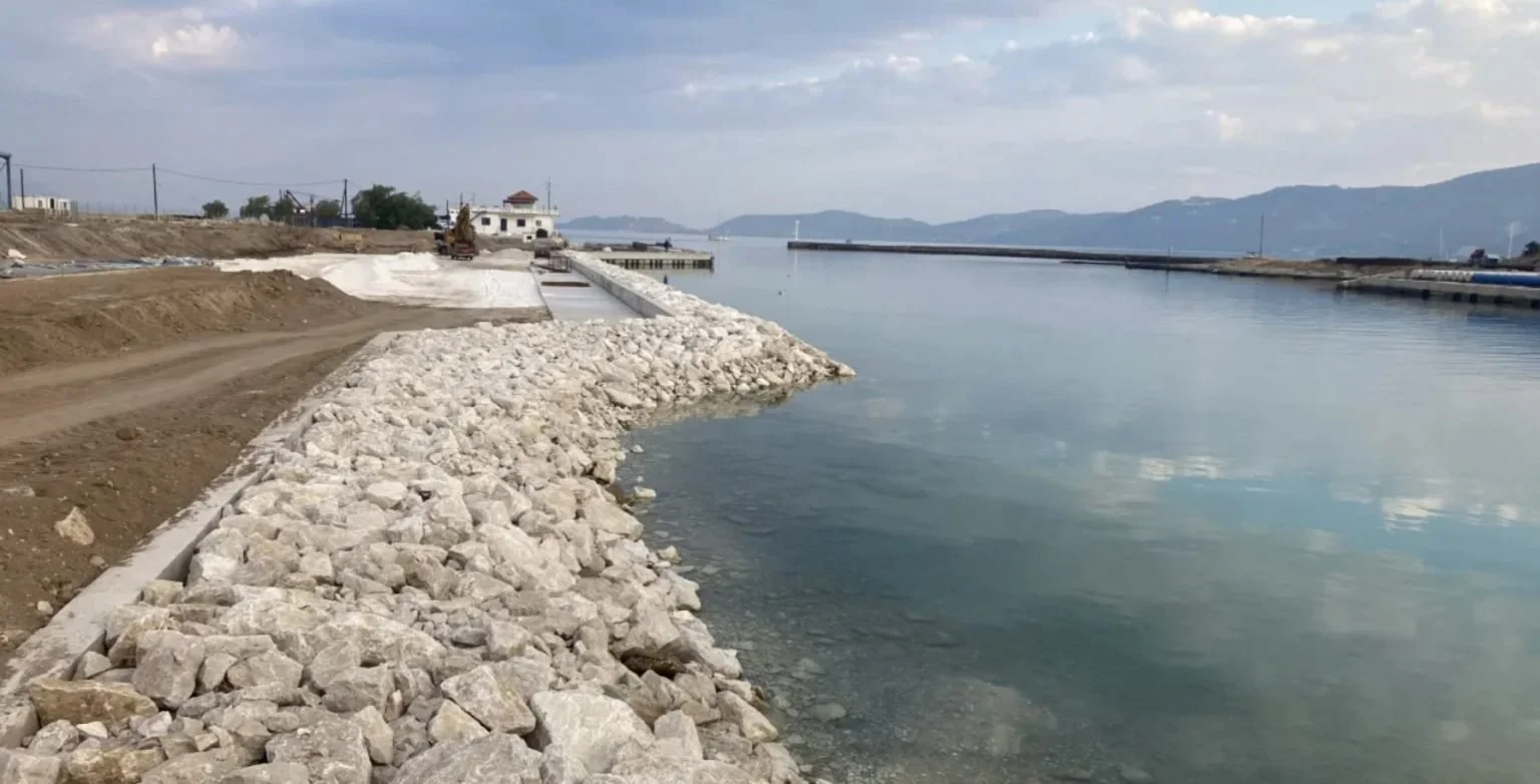
Ancient road on the Isthmus of Corinth resurfaces
Peloponnese Region is providing funds for the 2,100,000 euro project, which is being implemented to protect the passage of the Ancient Diolkos in the area of Poseidonia, west of the Corinth canal.
An extremely important project
It is simple to understand the necessity and significance of this arrangement for the ancient Greeks' trade. It released the ships from the hazards associated with the then multiple-day round of the Peloponnese, particularly the passage of the stormy capes of Malea and Tainaros. Diolkos had to have been constructed at the beginning of the sixth century BC, or at the very latest, at the end of the seventh century BC. Periandros was the dictator in Corinth at the time.
Excavations
Before 1956, when excavations to uncover Diolkos started near the Isthmus of Corinth, different theories concerning its location and structure had been put forth by younger scholars. Diolkos, in Fraser's opinion, ought to resemble a "tramway." Based on Pausanias' report, it was based on the observation of a little portion that had been maintained close to the canal bridge. Another stretch of road in Peloponnesian land, at the mouth of the canal leading to the Corinthian Gulf, was also credited to Diolkos by Fowler (Corinth, vol. I, p. 50). But N. Verdelis' excavations unveiled a sizable portion of Diolkos and provided answers to issues raised by it.
The path
Initially, the precise path it took was identified: It began in Corinthiakos, which is now the location of the signal for ships traveling toward the canal. For a while, it was traveling eastward. It then moved once more toward the southeast before turning northeast. As described by Strabo, it continued until it reached the old Schinounda, which is now Kalamaki Corinthia, in the Saronic Gulf east of the canal.

IT stayed away from the ground's incline
Diolkos was moving in a crooked direction. Because of the terrain's twists and steepness, which reached an altitude of up to 90 meters, transporting ships would be very challenging. Commercial ships left their cargo in Cenchrees or Lechaion rather than transporting it loaded. The information provided by Pliny and Hesychius, who identified these two ports as the beginning and end of Diolkos, can only be understood in light of this interpretation.
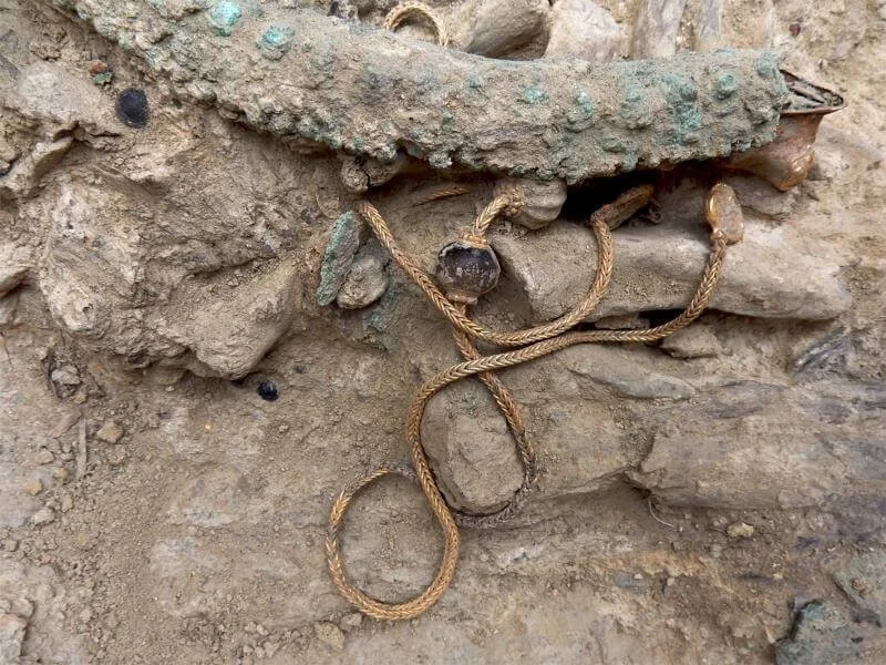
Crusader blade found by a diver overboard was probably lost in combat
Archaeologists revealed in a new article that was recently published in the 'Atiqot journal that a sword that was discovered by a diver off the coast of northern Israel in 2021 was likely lost overboard during a fierce naval battle between Crusaders and Muslim residents of coastal cities about 800 years ago.
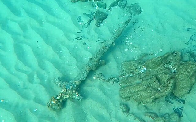
The 800-year-old Crusader sword as it was found in the sea off the coast of Neve Yam in October 2021. (Shlomi Katzin/IAA)
Shlomi Katzin, a recreational diver, discovered the iron sword encrusted in shells, sand, and cemented microorganisms, commonly known as a "biogenic crust," after he lifted it from the seabed. Since iron often oxidizes and breaks down in salt water, this crust kept the blade intact for generations.
But it was difficult for experts to study the sword more closely due to the thick covering of shells and sand.
In a collaboration with the Soreq Nuclear Research Center, the Israel Antiquities Authority used cutting-edge X-ray radiography equipment to visibly pierce the crust and simulate the sword. A government research facility with a focus on nuclear and photonics technology is called the Soreq Center.

Early research cracked the marine crust and exposed the iron blade, splitting it, forcing researchers to adopt noninvasive methods of study. (Daphna Gazit/IAA)
A significant portion of the iron blade was exposed and broke open during early studies on the sword when the crust fractured. The decision was made to just use non-invasive techniques to continue researching the sword.
Due to the crossbar (part of the handle) being smacked out of alignment and the slight bending of the blade, which was shown by the X-rays, researchers believe the sword was almost probably lost overboard during a combat.
The sword most likely fell into the water during a battle, according to Dr. Joppe Gosker of the Israel Antiquities Authority.
Swords are typically seen in a scabbard because they are pricey, he continued. "Only the sword was discovered in this case. This suggests that it fell into the water during a conflict, perhaps with its owner. Our scans of the area turned up no additional remains, but you never know. The warrior might still be hidden deep within, waiting for the sands to reveal him one day.

An x-ray of the Crusader sword's hilt. (Isaac Hershko/Soreq Nuclear Research Center)
Due to the high cost of iron and the common practice of turning swords into other implements, very few swords have been discovered on land. With a blade from the 12th century and a pommel or handle from the 13th century, this weapon was probably a European sword.
Long and straight, "used for stabbing and slashing," the experts said of the European medieval sword in their article. experts believe it belonged to a Crusader, possibly a member of the aristocracy who had the time and resources to train fencing. Swords in the Islamic world during this time period typically had curved blades, which is why experts assume it was a Crusader sword.
Jacob Sharvit, the head of IAA's maritime archaeology unit, claimed that the sword belonged to a Crusader fighter who lived in the region after the First Crusade and founded the Kingdom of Jerusalem in 1099. "We could anticipate finding more such swords given the brutal conflicts that occurred there between the Muslims and Crusaders, which are known from numerous historical sources. In reality, we mainly discover broken swords and relatively few complete ones. Seven swords from this era have so far been unearthed in the nation, the most of them in the water, according to Sharvit.
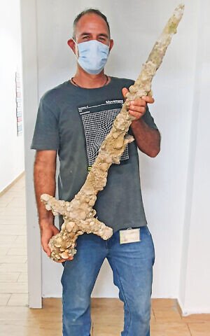
Diver Shlomi Katzin with the sword he discovered off the coast of Neve Yam in October 2021. (Nir Distelfeld/Israel Antiquities Authority)
With the liberation of Jerusalem from the Fatimid Caliphate in 1099, the Crusader era in Israel began and lasted for almost 200 years. Following their conquest of Jerusalem, the Crusaders—a missionary army made up of priests, knights, princes, aristocrats, and commoners—marched on the coastal cities that were then ruled by the Muslims.
Due to their dependency on supplies from Europe, the Crusaders had to maintain control of the ports in order to survive. Naval vessels from Pisa, Venice, and other Italian republics attacked Muslim coastal cities during the Crusader era.

Stone Age road from 7,000 years ago found at the bottom of the Mediterranean
The ruins of a Stone Age road, constructed 7,000 years ago, were found at the bottom of the Mediterranean Sea by archaeologists after studying satellite photographs of the sea surrounding the now-submerged Neolithic site of Soline, off the coast of Croatia.
When Soline was the location of the ancient Hvar civilization, it is thought that this road originally connected the Croatian islands of Korcula with that region. The Adriatic island of Korcula was first connected to the continent.
The University of Zadar's Mate Parica, an archaeologist, and his colleagues initiated the initial investigation that led to the discovery of Soline.

According to Parica, who made the first discovery, "this area, unlike most sections of the Mediterranean, is safe from strong waves because the many surrounding islands 'cut' the waves and protect the coast." "It undoubtedly prevented a natural disaster from occurring at the place."
As radiocarbon research of the conserved wood discovered at the site revealed that the Soline settlement dates back to approximately 4,900 BC, archaeologists believe that the road was constructed by the Hvar-Lisičići culture.
It is around 4 meters wide and was skillfully built out of stone slabs.
According to historians and archaeologists, the Stone Age Hvar culture is thought to have created trade routes between the island and the eastern Mediterranean coastlines of what is now western Asia.
Researchers find the earliest signs of curry outside of India
According to a recent study that uncovers the earliest evidence of culinary spice commerce outside of the Indian subcontinent, curry dishes were first transported to southeast Asia around 2,000 years ago.

This footed sandstone grinding slab, 76 cm long by 31 cm wide, was excavated in 2018
More information about the impact of the globe spice trade on world history is provided by the findings, which were just published in the journal Science Advances.
In the study, archaeologists from Australian National University and other institutions examined plant remnants found on the surfaces of stone grinding tools discovered in Vietnam.
Researchers discovered grinding slabs and mortars and pestles that resembled early South Asian stone implements used for curry preparation in the Funan-era archeological site "c Eo" in southern Vietnam.
"The artifacts analyzed correspond with archaeological and traditional Indian spice grinding tools, designed to release the flavors and tastes that characterize different spices," researchers said in the paper.
These relics could be linked to the South Asian and Indonesian spices that are being used to make South Asian curries today.
For more than 4,000 years, South Asia has been a major supplier of spices for civilizations in Asia and Europe.
As a hub for trade between south Asia and China during the Funan era (65–580 AD), Indonesian spices like nutmeg and clove also played a crucial part in the maritime spice trade.
It is also known that the rise in the use of spices as food flavoring and preservatives helped to usher in the era of European colonization of the East.
Researchers note that there is only a little amount of direct biological evidence for the use of spices in cooking in south and southeast Asia during this historical period and previous times.
It has remained unknown whether or how these spices may have been used in southeast Asian cuisine throughout that time due to the lack of such evidence.
Additionally, they examined 717 grains of starch, pollen, and silica from plant tissues that were detected on the surfaces of 12 of these tools.
Spices and rice residues with primary origins in south Asia and Indonesia were found by researchers.
These comprised cinnamon, nutmeg, clove, ginger, galangal, fingerroot, and sand ginger.
According to researchers, the latest discoveries offer some of the earliest proof of curry production and the use of many of these spices in southeast Asia.
"We propose that this culinary tradition was brought into Southeast Asia by South Asian migrants or visitors during the early trade contact via the Indian Ocean, beginning about 2000 years ago," researchers stated.
Recent findings regarding the Antikythera wreck
The movie "Indiana Jones and the Dial of Destiny" recently brought attention to the ruin of Antikythera. An multinational team of archaeologists, divers, engineers, and physical and natural scientists are actively exploring the renowned wreck, far from the fantasies of the movies.

The researchers' understanding of the site's structure, stratigraphy, the wreck itself, and its priceless cargo has advanced significantly this year. Additionally, previously uncharted territory has been painstakingly researched, allowing for a more clear-cut understanding of this fabled ship.
Dr. Angeliki G. Simosi, Director of the Ephorate of Antiquities of Piraeus and the Islands, and Lorenz Baumer, Professor of Archaeology at the University of Geneva (UNIGE), directed the trip, which took place from May 19 to June 18, 2023.
It is a component of a five-year (2021-2025) UNIGE research program. By carefully investigating the wreck's preservation and location, its potential route, and its contents, these excavations are ultimately intended to help us better comprehend the circumstances that led to the sinking. To create a comprehensive understanding of this awful historical event, this season's discoveries are crucial.
Advanced technologies
Remote-controlled drones and digital photography taken by the divers were used to meticulously record the excavations' development. Using 3D modeling software, this data was processed daily, allowing for remarkably accurate visualization and analysis of the location. All archaeological discoveries were also meticulously recorded and regularly linked into a Geographic Information System (GIS), allowing for the analysis of the distribution of discoveries over time and space.
All information that is now known about the wreck of Antikythera, dating back to the initial digs in 1900–1901, is included in the database for this complex effort. With the aid of this all-encompassing strategy, the site may be thoroughly and in-depth analyzed while taking into consideration all previously gathered data.
A second ship was found
The easternmost portion of the shipwreck site, where gigantic marble statue pieces were discovered last year after a collection of sizable natural rocks were removed, was the focus of the excavations. This time, the team found the bone remains of at least one more person who tragically perished in the terrible catastrophe.
Objects resembling the Antikythera wreck, such as pieces of marble statues, pottery, glassware, and copper alloy, lead, and wooden ship parts, were also discovered. One of the marble shards found most likely came from the Herakles beard, which was previously located by the expedition in 2022. These discoveries attest to the Antikythera wreck's significance for culture and the arts.
A fascinating find was also made at a higher stratigraphic level. The discovery of many pieces of late pottery suggests that another, perhaps much smaller vessel met the same terrible demise during proto-Byzantine periods.
This new knowledge highlights the value of ongoing archaeological research in this area and brings up fascinating perspectives on the marine history of the area.
The richest ancient wreck ever found in Greece is the wreck of Antikythera, which dates to the first half of the first century BC. It was discovered by accident in 1900 off the coast of Antikythera, and it was later unearthed by Commander Cousteau in the 1970s by Greek archaeologists between 2012 and 2020. The project has being run under the auspices of the Swiss Archaeological School in Greece since 2021 by the University of Geneva.
Discreet Roman dog remains were discovered during an excavation in Oxford
At a well-liked walking location, the skeletal remains of a little Roman dog were found.
Affectionately known locally as "The Clumps", the site is owned and managed by Earth Trust
The 1,800-year-old remains of a 20 cm tall dog were discovered during an archaeological investigation at Wittenham Clumps in Oxfordshire.
The animal's remains were discovered in the location of what is thought to have been a villa occupied by an affluent Roman family.
According to researchers, the dog was probably a "much-loved pet" and is one of the tiniest ones ever discovered in the UK.
The find was made by archaeologists from DigVentures, a social organization that coordinates crowdfunded archaeological excavations, at the location of the charity Earth Trust's headquarters.
While it's likely that this dog was employed for hunting, Hannah Russ, a zooarchaeologist who examined the animal remains, noted: "We know that Romans in other regions of the empire had begun to raise and keep little dogs as pets.
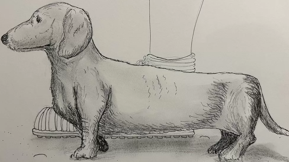
A sketch of what researchers believe the small dog would have looked like
It is quite likely that this dog was maintained as a house dog, lap dog, or pet because of her petite size and bowed legs rather than being bred as a hunting dog.
A "relatively wealthy Roman family, who ran a farm with an assortment of working animals, including hunting or herding dogs - as well as this tiny canine" would have resided in the uncovered villa, according to Maiya Pina-Dacier of DigVentures.
The remains will be on exhibit for the first time at Earth Trust in August as part of the Clumps Go Ancient festival, together with other discoveries from the excavation, such as a brooch and a copper bracelet.
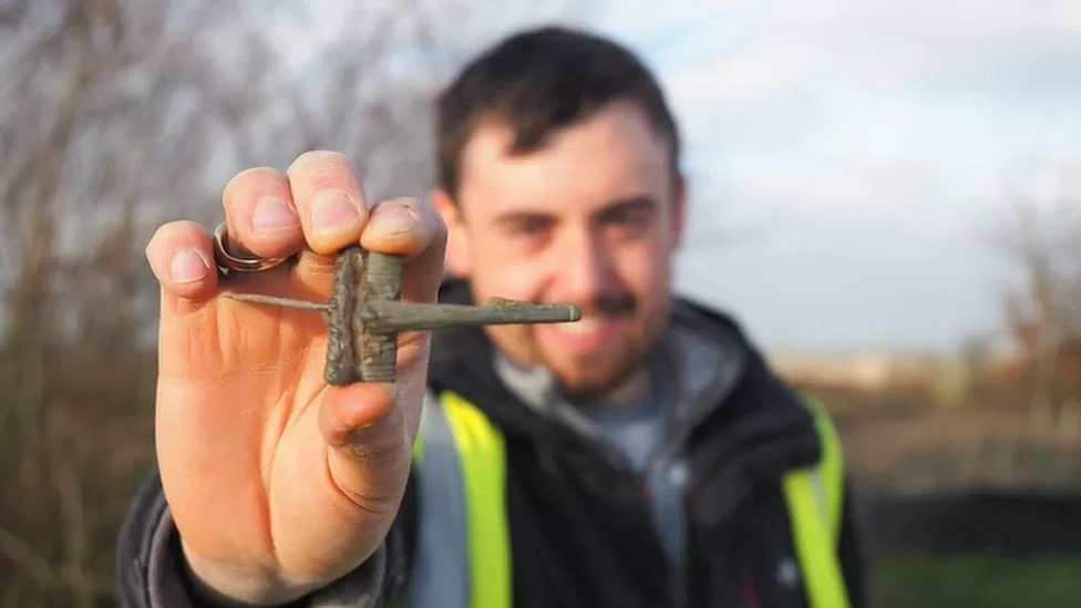
A member of DigVentures holds a brooch also uncovered at the site
The Earth Trust announced that it would involve demonstrations to bring the findings of the people of Wittenham Clumps and their animals to life as well as a pop-up display with "never-before-seen artifacts" from the excavation.
In a statement, it was stated that "this area has been shaped by human use and intervention throughout the ages, from the Iron Age communities who created the hillfort that is now Castle Hill -- and the Roman families who later lived downslope -- to the farmers and tenants who manage the land today."
A Scientific Debate is Sparked by a Netflix Documentary About Ancient Human Burials
Is Rising Star Cave still a mystery, or did our long-lost cousins the hominins go there to make graves for their dead?

According to a series of recent studies by the species' discoverers, University of Witwatersrand paleoanthropologist Lee Berger and his colleagues, Homo naledi, a diminutive, primitive-appearing relative of our species, may have marked the graves of its dead with etchings on cave walls and buried its corpses. Even on Netflix, there is a documentary that tells the tale of Homo naledi death ceremonies.
Other scientists, however, are dubious about whether the evidence actually supports interment rather than just the erosion-caused sedimentation of remains. No one disputes the significance of these fossils or the location; the argument is on what the fossils reveal about these little hominins and how certain we can be given the data at hand.
A Deep Cave With Shallow Graves?
When Berger and his colleagues announced in 2015 that they had discovered a new species of hominin, it caused debate since it is a big claim to make. Homo naledi, although having a considerably older-looking resemblance to modern humans, may have roamed the South African plains around 300,000 years ago, according to dating.

A general view of "NEO" a new skeleton fossil findings of the Homo Naledi Hominin species is pictured at the cradle of Human Kind in Maropeng near Johannesburg on May 9, 2017 in South Africa.
Berger used a unique method to disseminating his discovery from the beginning. And in the eight years that have passed, Berger and his associates have made even stranger claims about Homo naledi: that these diminutive, small-brained hominins had intentionally carried their dead into the Rising Star Cave System, that they had used fire to light their way, and most recently, that they had actually buried their dead in shallow pits and then carved marks on the cave walls nearby.
In light of the facts at hand, other paleoanthropologists disagree, but Berger and his colleagues continue to stand by their assertions.
Awesome Evidence is Required for Awesome Claims
Pre-prints are research papers that scientists have finished writing but have not yet had peer review or been accepted for publication by a journal. The most recent claims, that Homo naledi not only carried its dead into the caves but actually buried them there in shallow graves in the dark, were first published in a set of pre-prints. Before scientific study is published, it is customary for a team of scientists who weren't engaged in the project to read the manuscript and review the data. Instead of just accepting one other's word for it, scientists check each other's work through peer review.
The papers are currently being reviewed at an open-access journal called eLife, and the four anonymous reviewers, who are also paleoanthropologists and were chosen by the journal's editors for their expertise in studying hominin fossils, are highly doubtful that Homo naledi actually dug graves deep underground.

An artist’s reconstruction of what Homo naledi may have looked like.
The conclusion of anonymous Reviewer #2 was, "While I understand the relevance of examining probable planned burials in Homo naledi, I do not think that in its present form, the data presented in this study is as substantial as it should be.
The specific issues raised by the reviewers range from the lack of a schematic showing the arrangement of the bones to the failure to consider erosion as a potential explanation for their placement in the cave. In the end, it comes down to the general conclusion that while there is no proof that Homo naledi buried its dead, there is also insufficient proof to conclude with certainty that they did. Berger was extremely transparent with his data in 2015, but the reviewers claim that this time around, he and his colleagues completely omitted certain important information from the report.
Other paleoanthropologists who weren't engaged in the Rising Star research or the review process have also commented. Most of them are dubious, though not about the possibility that Homo naledi buried its dead but rather about the certainty that it did.
On the study's eLife page, Berger and his coworkers' responses to reviewers are available. They also want to revise the manuscript and add further evidence. Berger has been far less circumspect in his press interviews. One thing is certain: the discussion is just getting started, and we'll get to watch it unfold in real time rather than over the course of years of slowly exchanging opposing journal articles.
How was England formed?
The existence of England is one that is often taken for granted and looked at far too scarcely. This may be due to the overshadowing history of the development of Great Britain and the United Kingdom, but nonetheless, in order for these unions to be formed, England had to already exist - and it actually has since 927 AD. So, how was England created, who claimed the land before the English, and how did it become the nation that we know today?
The Oldest (Known) Song of All Time
The Hurrian Hymn is History's first Song. Well, the oldest known song. If we're really splitting hairs: the earliest written song that can be reconstructed. We're not even sure what the song even sounds like, but each attempt to decode has its own value. All we are sure about is that the Hurrian Hymn is really, really ancient and nothing is as clear as it seems.
The AWFUL Hygiene During the Aztec Empire Will DISTURB You
What was Aztec hygiene like?
The Aztecs, a Mesoamerican group that thrived from the 14th to 16th centuries, inherited cultural practices from their predecessors, the Mayans, and Toltecs. They valued cleanliness and purity, which was reflected in their hygiene practices. When the Spanish arrived in the early 16th century, they were impressed by the Aztecs' cleanliness, which contrasted with European practices at the time. The Aztec Empire went to great lengths to provide clean water and promote hygiene using natural ingredients, which were intertwined with physical and spiritual considerations. Their canal system transported clean water around the cities, demonstrating their understanding of water's importance to all aspects of life.
Spartan Diet and Culture
In Plutarch's work "The Moralia" (Ancient Greek: Ἠθικά Ethika; loosely translated as "Morals" or "Matters relating to customs and morals") he gives us a description of Spartan customs and diet. However, many historians take this account with a large grain of salt as Plutarch lived a few centuries later than the height of Sparta.
Plutarch (c. AD 45-119), the Greek philosopher, lived at the height of the Roman Empire and is author of one of the largest and collections of writings to have survived from Classical antiquity. His work is traditionally divided into two: the Moralia, which include a vast range of philosophical, scientific, moral and rhetorical works, and the Lives or biographies. Almost fifty such biographies survive, most from his collection of Parallel Lives, in which biographies of Greek and Roman statesmen are arranged in pairs.
On a Side Note | Mercenaries in the Greek World
Mercenaries in the Greek world played a pivotal role, not just as soldiers for hire, but also as an important aspect of society and politics. In the late Classical Era and Hellenistic Era, mercenaries would define history and play an unprecedented part in the world!