After a thousand years, a "long-lost city of Gods" was found by lasers in a deep jungle

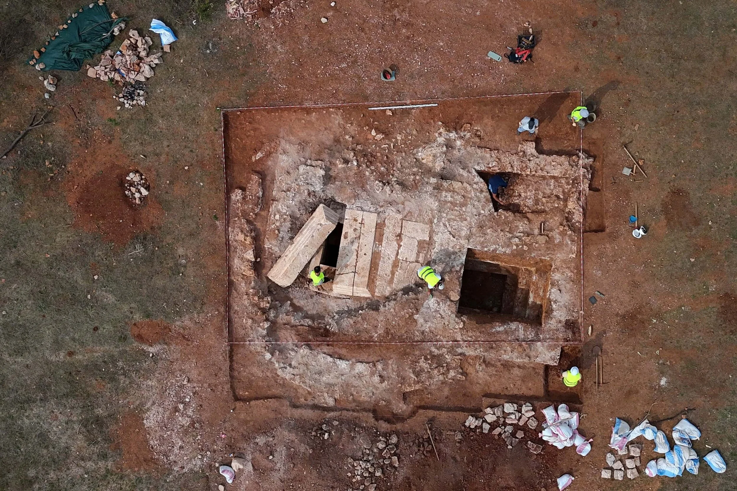
In a jungle in north-west Cambodia, a long-lost ancient city was found by researchers.

Laser technology revealed the Khmer empire's oldest city (Image: Getty Images)

Mahendraparvata, which translates as "Mountain of Indra (King of Gods)," was supposed to have been the initial capital of the Khmer Empire and was a vibrant metropolis more than a thousand years ago.

Scientists had even disagreed on the best place to hunt for the remnants of this enigmatic location, after decades of futile search efforts.

That is, until a trailblazing expedition that ended in 2019 unearthed a trove of knowledge about the hidden city, which is nearly 300 years older than the iconic Angkor Wat structure.

The city had been hidden for over 1,000 years (Image: Getty Images/500px)

When Khmer ruler Jayavarman II was dedicated in 802 AD, Mahendraparvata was discovered, according to analysis of the find in Phnom Kulen National Park. The historic Khmer Empire was established at this time.

Modern Lidar (light detection and ranging) laser-scanning techniques were used to precisely locate the city, which is situated 40 kilometers north of Angkor Wat, the greatest temple in the world.

Archaeologist Jean-Baptiste Chevance of the Archaeology and Development Foundation in the UK noted in a report on the amazing discovery that comprised over two dozen previously unrecorded temples: "The mountainous region of Phnom Kulen has, to date, received strikingly little attention. It is almost entirely missing from archaeological maps, except as a scatter of points denoting the remains of some brick temples

It is not thought the city was inhabited for long (Image: Getty Images/iStockphoto)

"The Ancient Khmer modified the landscape, shaping features on a very large scale – ponds, reservoirs, canals, roads, temples, rice fields and more. However, the dense forest often covering the areas of interest is a main constraint to investigating them", he continued.

However, a major obstacle to exploring the locations of interest is frequently the dense forest that covers them.

The team's use of laser technology allowed them to see through centuries' worth of vegetation that had grown over the city's ruins.

Then, across the jungle's 50 sq km, they could see a vast urban network.

Jayavarman II was consecrated at Mahendraparvata, founding the Khmer Empire (Image: Getty Images)

According to the researchers, "numerous other elements of the anthropogenic landscape connect to this broader network, suggesting the elaboration of an overall urban plan. Dams, reservoir walls and the enclosure walls of temples, neighbourhoods and even the royal palace abut or coincide with the embanked linear features."

Despite its vastness, the city was not inhabited for very long since people moved to easier-to-live-in terrains.

Damian Evans, of the French School of the Far East, told the New Scientist: "The city may not have lasted for centuries, or perhaps even decades. But the cultural and religious significance of the place has lasted right up until the present day."

Source: https://www.dailystar.co.uk/news/weird-new...

The largest discovery in Norway in more than a century is made by a metal detectorist: antique gold jewelry

An amateur metal detectorist in Norway is enjoying his good fortune after discovering what might be the country's largest ancient gold discovery in more than a century. Of course, it could simply be beginner's luck.

Image courtesy of Archaeological Museum at the University of Stavanger

Beginning in September, the Archaeological Museum at the University of Stavanger revealed the discovery of a cache of gold artifacts dating back more than 1,500 years on the island of Rennesy in southwest Norway. The hoard weighed almost 100 grams.

In the news statement that was translated from Norwegian, director Ole Madsen of the Archaeological Museum at the University of Stavanger noted, “this is the gold find of the century in Norway. To find so much gold at the same time is extremely unusual.”

Erlend Bore, a native of Sola, found the gold cache. The 51-year-old man purchased his metal detector a year ago, and, according to the museum, he mostly views it as a hobby to get him outside the house.

Bore relocated to a higher location after spending the majority of the day searching the beach on Rennesøy without much success. Initially, he didn't know what he had discovered, he continued.

"At first, I thought I had found chocolate money or Captain Sabertooth coins. It was completely unreal," Bore said.

The museum claimed that even though the gold disks appeared to be ancient coins, they were actually pieces of jewelry. The museum stated that the gold pendants, known as "bracteaters," were not used to buy or trade items but rather as adornment.

The jewelry, according to associate professor at the museum Hkon Reiersen, dates to roughly 500 AD. The braceleteters were also found with round gold pearls.

The gold pearls and nine bracteates combine to make a really ostentatious necklace. The most influential members of society wore the jewelry, which was created by talented jewelers. It is really uncommon to find so many braceaters in one place. It hasn't happened in Norway since the 19th century, and it's a really unique discovery in the context of Scandinavia, according to Reiersen.

The design on the gold disks, according to the museum, further distinguishes this find as being special. The brackets have images of horses on them.

According to the Museum, the pendants' emblems traditionally depict the god Odin tending to the ailing horse of his son Balder. These gold disks, however, just display the horse's appearance.

Marianne Enoksen, section manager for cultural heritage in Rogaland County Municipality, said, “None of the archaeologists in Rogaland County Municipality have experienced anything like this, and it is difficult to describe the excitement when we got to see these.”

All items discovered that date back to 1537 and coins older than 1650 are regarded as state property under Norwegian law and must be reported and given to the authorities.

A finder's fee, which must be split equally between the landowner and the finder, is permitted under the Cultural Heritage Act for those who discover loose cultural heritage. The worth of the items Bore found has not yet been established by the museum.

Source: https://www.kitco.com/news/2023-09-11/Meta...

Ancient magical ritual objects were uncovered along the Darb al-Hajj route from Cairo to Mecca

A recently published study suggests that the objects, which were discovered in the 1990s along the historic Darb al-Hajj route from Cairo to Mecca, may have been used in magical ceremonies.

Dr. Itamar Taxel of the Israel Antiquities Authority recently published a research in which he examined a group of items found in the late 1990s at an archaeological site in the Eilat mountains. The Journal of Material Cultures in the Muslim World recently released their research.

The collection of artifacts was discovered by Moti Shemtov in the late 1990s along the old Darb al-Hajj route in the Eilat mountains of southern Israel. It contains pieces of table tennis ball-sized clay rattles that contained small stones and made sound when shaken. Along with other figures, including one of a bare-chested woman or goddess with raised hands, two items that resembled miniature votive incense altars were also discovered.

The study claims that these objects were used in mystical rituals to ward off the evil eye, treat illness, and other things.

Clay rattle fragment. Photo: Clara Amit, Israel Antiquities Authority.

According to the researchers, "this discovery reveals that people in the Early Ottoman Period—just as today—consulted popular sorcerers, alongside the formal belief in the official religion."

The ceramic objects came from Egypt, according to a study of them. The IAA claimed that this significant collection of ceremonial objects had never before been discovered, especially at a transient location as opposed to a permanent settlement.

Before continuing onto the Arabian Peninsula, the Darb al-Hajj left Cairo and passed via the Sinai Peninsula, the Eilat region, and the town of Aqaba. From the early centuries after the rise of Islam, or from the 7th century to the 19th century, this route was in use.

There have been found to be a number of pilgrims' campsites and buildings close to the Eilat mountains. These buildings appear to have been largely used throughout the Mamluk and Ottoman eras, which started in the 13th or 14th century C.E.

Colored quartz pebbles. Photo: Clara Amit, Israel Antiquities Authority.

Many of the items were found broken, according to Dr. Itamar Taxel, which suggests they may have been deliberately damaged during ceremonies.

The items were discovered broken, and it's possible that they were deliberately damaged during the rituals. It appears that one or more individuals with experience in common magical rituals performed these rituals at the location. From the literary sources, we can infer that people from many social strata had a need for magical rites. It is likely that pilgrims traveling to the holy cities of Mecca and Medina participated in such rites together with the formal religious ceremonies on a daily basis, especially in the Muslim world.

The Darb al-Hajj route intersects Eilat's municipal boundaries, positioning the city to become a part of a distinctive regional archaeological and tourist area, according to Omry Barzilai, the IAA's southern regional archaeologist.

Source: https://arkeonews.net/artifacts-used-for-a...

Lost Celtic "rainbow cup" coin from 2,000 years ago was found in Germany

The term "rainbow cups" refers to the gold drops that are said to descend to Earth at the end of a rainbow.

The motif of the four-pointed star surrounded by four arches is rare, as there are only three known Celtic rainbow cup coins with this design. (Image credit: © Photo Stefanie Friedrich, Archaeological State Collection (Munich))

According to the Bavarian State Archaeological Collection, a very rare "rainbow cup" coin made by the Celts more than 2,000 years ago has been discovered in Germany close to a river.

According to Bernward Ziegaus, a senior curator in the State Archaeological Collection's numismatic department who is analyzing the currency, the gold piece, struck in the second or first century B.C., has a unique design on one side that has a four-pointed star encircled by arches. The coin is curved like other rainbow cups are.

"The name rainbow cup coins come from the legend that they are drops of gold that fall to earth at the end of a rainbow," Ziegaus told Live Science in an email. "Another legend about these Celtic coins tells us that these coins can only be found by Sunday children," or a child of fortune.

"In fact, the finder was born on a Sunday and is indeed a Sunday child, a lucky child!" he mentioned.

The coin was found this spring on the Lech River in the southern state of Bavaria by the finder, who was working with state archaeologists. The location is around 45 miles (70 km) west of Munich.

The location is close to an old road, however it is uncertain how the 0.07 ounce (1.9 grams) coin ended up there. The Roman route Via Claudia Augusta crossed the Alps and originated in what is now Trento, northern Italy, according to Ziegaus.

"Perhaps the coin was accidentally lost along the way," he said.

The "heads" side of the 13 millimeter (0.5 inch) wide coin "shows a stylized human head with a large eye," Ziegaus stated. The nose and lips are shown as dots. According to a metal study, the currency is made up of 77% gold, 18% silver, and 5% copper.

The "heads" side of the rainbow cup Celtic coin that displays a stylized human head. (Image credit: © Photo Stefanie Friedrich, Archaeological State Collection (Munich))

With the star and arch design, there are only three known rainbow cups. Ziegaus remarked that it was challenging to interpret the motivation. "The star is perhaps a symbol for the four cardinal points, the arches are to be understood as signs for the horizon and the rising and setting of the moon."

The powerful warriors known as the Celts flourished throughout mainland Europe in antiquity and subsequently took over Rome. The earliest Celtic coins found in Bavaria date to the third century B.C., however Ziegaus claimed that Celtic coinage was abandoned after the Roman conquest of the area in 15 B.C. Roman coinage took over as the region's primary form of payment after then.

Even if it's just one coin, it's still a fantastic find. Because there have only been a very small number of specimens of this kind discovered thus far, according to Marjanko Pileki, a doctorate candidate at Goethe University Frankfurt studying the archaeology of coinage, money, and the ancient economy.

If additional rainbow cups are discovered nearby, "a picture of the [currency's] distribution can be drawn," Pilekić wrote in an email to Live Science.

The rainbow cup was given to the Munich-based Bavarian State Archaeological Collection by the coin's finder. It will go on permanent exhibit at the museum with other priceless Celtic coin artifacts in 2024 since it is "extremely rare," according to Ziegaus.

Source: https://www.livescience.com/archaeology/lo...

Spain Discovers Unprecedented 24,000-Year-Old Paleolithic Art Sanctuary

In a grotto in Spain's Valencia province, the largest collection of prehistoric cave art in Eastern Iberia has been found. The huge collection of engravings and paintings, which number over 100 pieces and include at least 19 different species, has been dated to be more than 24,000 years old.

Some of the artworks at Cova Dones had been distorted by cave bear claw marks, indicating their age.

The ancient artworks, which were discovered in a cave called Cova Dones, are remarkable in a number of ways, and archaeologists were surprised by their unanticipated location. Only three instances of Pleistocene cave art had ever been uncovered in eastern Spain before this find, with the great majority being situated in the country's north and across the Pyrenees into France.

Cova Dones, a popular hiking and caving destination in the Millares municipality, has long been known to locals. However, it wasn't until June 2021 that scientists became aware of the amazing murals that grace the cave's walls. According to the team's description of their find in a recent article, "further work in 2023 allowed us to identify the site as a major Palaeolithic art sanctuary, given the quantity and variety of motifs and the richness and detail of its technical features."

An engraving of a female red deer.

According to the study's authors, "more than 110 graphic units" have so far been located, with the primary decorated section being located some 400 meters (1,312 feet) inside the cave. At least 19 different animals, including seven horses, seven female red deer, two aurochs, a stag, and two unidentified species, have been identified in these drawings, according to the experts.

The remaining graphics are composed of "conventional signs," such as rectangles and other shapes, as well as "macaroni," which are markings that resemble tubes. Researchers claim that the ancient artists used a surprising variety of techniques and abilities, sometimes scraping off limestone precipitate off the surface of the walls to form shaded figures. The authors write that this method is uncommon in Palaeolithic cave art and was previously unheard of in eastern Iberia.

The majority of the paintings in Cova Dones were made by adding red clay to the walls, which is equally astounding. The use of clay in prehistoric cave paintings was a very unexpected discovery because typically, diluted ochre or manganese powder were used to create them.

Painted female deer heads.

The authors of the study emphasize in their report that it is impossible to establish the date of the artworks with certainty. However, several characteristics of the cave walls do offer some indications as to when the drawings may have been made.

Most significantly, the presence of claw marks from cave bears helps to date some of the engravings. The fact that some of the etched images are covered by these scratches shows that the animal responsible entered the cave after the artists had finished their work.

The researchers conclude that at least some of the rock art must be older than 24,000 years based on the dating for the demise of the cave bear.

Source: https://www.iflscience.com/unprecedented-2...

Ancient rituals performed at strange stone buildings in north-western Arabia are revealed by the discovery of the "Horn Chamber"

The findings of two recent excavations funded by the Royal Commission for AlUla (RCU) show that the Neolithic people of northwest Arabia engaged in "complex and sophisticated ritual practices" in the late 6th millennium BCE.

The team led by Dr Wael Abu-Azizeh excavates the chamber that contained “an exceptional discovery” of skull and horn fragments. Credit: Muhammad Al-Dajani / RCU

The exceptional finds open unknown opportunities for a fuller understanding of the social, cultural and spiritual backdrop of the ancient peoples of north-west Arabia.

Researchers stress that the practice was likely communal in nature and that it is possible that individuals traveled expressly to mustatils, prehistoric stone structures, to perform the ritual. If so, this would be one of the earliest documented pilgrimage rituals. The pastoral nomadic nature of the group, whose members may have constructed the mustatils as a means of social bonding and/or a territorial marking, is further supported by the larger presence of domestic species among the animal gifts.

Large rectangular open-air constructions called mustatils with low stone walls. Researchers have located more than 1,600 of them in north Arabia through aerial scans. Although the purpose of the structures was first unknown, excavations since 2018 have shown a ritual importance and given further information about the activity.

The outcomes of the two investigations have just been published after peer assessment. A group of experts lead by Dr. Rebecca Foote, Director of Archaeology at RCU, authored the book "Revealing Cultural Landscapes in North-West Arabia," which includes a study conducted by Dr. Wael Abu-Azizeh of the Archéorient Laboratory and France's Lyon 2 University. The study, which was directed by Dr. Melissa Kennedy of the University of Sydney in Australia, was published in the PLoS One journal in March.

Abu-Azizeh research

For Oxford Archaeology, Dr. Abu-Azizeh started an excavation in 2018 that resulted in the discovery of the "Horn Chamber" in a mustatil at site IDIHA-0000687 northeast of AlUla, dating to between 5300 and 5000 BCE. The chamber, which is smaller than typical mustatils at 3.25 by 0.8 meters, is located at the western end of a mustatil that measures 40 by 12 meters.

At top is a general view of the SU100 platform; at bottom are details of the horn chamber. Credit: Wael Abu-Azizeh et al 2022 / RCU

He and his crew found a remarkable find of horn and skull parts within the "Horn Chamber," which had a layer 20 to 30 cm thick covering the chamber's floor. According to their description, this is "a unique and unprecedented assemblage in the context of north Arabian Neolithic."

The majority of the horns and skull fragments, or about 95%, came from domestic animals including goats, sheep, and cattle. The remaining 5% came from wild animals such gazelles, Nubian ibex, and aurochs (a now-extinct predecessor of domestic cattle). The assemblage was resting on a thin layer of twigs that had been spread across the chamber's sandstone floor in advance of the rite.

The scientists come to the conclusion that a single ceremony is likely when the horns and pieces of skull were left there. They suggest that pastoral nomads gathered and carried the offerings as part of the ceremonial performance in their preliminary reconstruction of the ceremony. They passed through a small antechamber with hearths and a short doorway to enter the solemn little Horn Chamber where they presented this trophy on behalf of their social group. The assemblage of enshrined gifts revealed a unifying identity for the larger social community.

According to the researchers, "by the quantity of remains, the diversity of species represented, and the unusual state of preservation, this assemblage constitutes a unique and unprecedented discovery in the archaeological record of the region. This deposit is interpreted as a testimony of complex and sophisticated ritual practices…"

Kennedy research

At site IDIHA-0008222, east of AlUla, the second investigation, led by a group from the University of Western Australia at the time and under the direction of Dr. Kennedy, started excavation of a mustatil in 2019. They also discovered a chamber with horns and fragments of a skull dating to between 5200 and 5000 BCE, though not in as large of an amount as Abu-Azizeh's crew. These bones appeared to have been deposited in three or four phases over a generation or two as opposed to all at once, which is another difference.

Many of the skull fragments and horns came from goats, but most were from cattle. This discovery is "amongst the earliest attestation of domestic cattle and goat in northern Arabia."

The outline of the Kennedy team’s mustatil is at the forefront of this image of the landscape east of AlUla. They describe the location as “essentially hidden in the sandstone canyons”. Credit: Hugh Kennedy, AAKSA / RCU

An upright stone that stands in the center of the shrine is thought to have acted as the ritual's focal point. Around this standing stone, which was 0.8 meters high, the majority of the horns and skull fragments were left there. According to the researchers, this stone is a betyl, which is defined as "a mediator between humankind and the divine, acting as a proxy or a manifestation of an unknown Neolithic deity/deities or religious idea, to which the faunal elements were deposited as votive offerings." One of the earliest known betyls on the Arabian Peninsula would be this one.

The continuous use of the shrine over a number of years, according to the scholars, "represents one of the earliest examples of 'pilgrimage' or shrine revisiting currently identified in the Arabian Peninsula."

They make the intriguing claim that the mustatils' positioning may have had an ecological basis. The Middle Holocene Period saw an increase in the aridity of the Arabian climate, which necessitated mobility and permitted herding. The mustatils themselves may have been situated close to water sources, such as wadis, and the ritual may have been performed to ensure fertility and the continuation of rainfall. The authors claim that this is an important area for future study.

RCU has started one of the biggest archaeological research programs in the world, according to Dr. Rebecca Foote, director of archaeology and cultural heritage research. Twelve ongoing surveys, excavations, and specialized projects in AlUla and Khaybar are expanding our knowledge of the area's historical ecology, land use, and human habitation. Funerary avenues, mustatils, ancient cities, inscriptions in ten languages, rock art, and sophisticated agricultural methods are just a few of the rich cultural landscapes that are being uncovered. The first AlUla World Archaeology Summit will strengthen AlUla's position as a major center of archaeological activity.

In this overview of the Horn Chamber Mustatil (at IDIHA-0000687), SU300 marks the eastern wall of the mustatil, SU200 marks a stone cairn and SU100 marks the 7x2.5m platform containing the horn chamber. The cliff overhang protected the horn chamber from exposure to the elements, which accounts for the exceptional state of preservation. Credit: Wael Abu-Azizeh et al 2022 / RCU

World Archaeology Summit in AlUla

As RCU will hold the first AlUla World Archaeology Summit from September 13–15, 2023, AlUla's status as a center of archaeological activity will continue to grow.

The Summit serves as a forum for developing cultural heritage management and archaeology at the intersection of these two fields. In addition to enhancing the archaeological community and assisting in the preservation of shared history, this gathering of leaders from academia, government, non-governmental organizations, business, and young people who represent the next generation of archaeologists will also open up a larger discussion about what and how archaeology, and more broadly cultural heritage, can contribute to transformative changes in society.

Regarding the AlUla Royal Commission

In July 2017, a royal decree established the Royal Commission for AlUla (RCU) to protect and develop AlUla, a region in northwest Saudi Arabia with exceptional ecological and cultural significance. In order to develop AlUla as an attractive place to live, work, and visit, RCU's long-term plan specifies a responsible, sustainable, and considerate approach to urban and economic growth. This strategy protects the region's natural and historic heritage. This includes a wide range of activities in archaeology, tourism, culture, education, and the arts, demonstrating a dedication to achieving the goals of the Kingdom of Saudi Arabia's Vision 2030 program, which prioritizes economic diversification, local community empowerment, and cultural preservation.

Source: https://www.prnewswire.com/news-releases/d...

Until today, a 1,500-year-old palace-like residence was concealed by tropical vegetation

In the Mexican jungle, two residential building complexes were built more than 1,500 years ago.

Archaeologists found the sets of residential buildings at the Kahah Archaeological Zone in Mexico, officials said. INAH

Archaeologists have been trying to locate the buildings ever since, but to no avail—until now. According to a Sept. 7 news release from Mexico's National Institute of Anthropology and History, specialists recently uncovered the two structures buried behind many layers of jungle growth and foliage.

In southeast Mexico's Yucatán, at the Kabah Archaeological Zone, the houses were found. They were created, according to archaeologists, between 250 and 500 AD.

One of the buildings found in the group during the restoration. INAH

According to the organization, experts remarked that one of the mansions stood out from the rest due to its palatial aspect. The house had an 85-foot addition with a portico ornamented with nine apertures and eight pilasters, which, according to Britannica, are little columns erected against a wall.

A close-up view of the home during restoration work. INAH

According to archaeologists, the elaborately decorated house included sculptures showing feather, bird, and bead patterns. A approximately 30-foot-long stucco figurehead's remnants could be seen on the staircase.

At the site, archaeologists also found ceramic artifacts such polychrome bowls and practical jars.

Experts said the building had intricate carvings and designs. INAH

Source: https://www.kansascity.com/news/nation-wor...

Robot, a canine explorer, unearths one of the most stunning works of ancient art

In the Dordogne region of France on September 12, 1940, 18-year-old Marcel Ravidat was out walking his dog, Robot.

Robot discovered a hole in an uprooted tree while on the La Rochefoucauld-Montbel family's property and informed his owner.

Ravidat was intrigued and later returned with Jacques Marsal, Georges Agnel, and Simon Coencas.

The four people entered the cave through a 15-meter-deep hole, which they thought led to the adjacent Lascaux Manor.

Henri-Édouard-Prosper Breuil (L) joins Jacques Marsal, Marcel Ravidat and Georges Agniel, three of the four teenage "inventeurs" of the caveJerome CHATIN/Gamma-Rapho via Getty Images

They instead discovered cave walls adorned in pictures of animals, people, and abstract symbols.

Henri-Édouard-Prosper Breuil, a French archaeologist, researched the ancient artworks after the youngsters informed the authorities of their discovery. He learned that the main cavern, which is 20 meters broad and 5 meters high, is what makes up the Lascaux grotto.

About 600 paintings and almost 1,500 engravings are displayed on the walls.

Breuil (L) examines the cave art shortly after its discovery alongside Count Begouen, prehistory professor at the University of ToulouseJerome CHATIN/Gamma-Rapho/Getty

Numerous species of animals, including horses, red deer, stags, cattle, cats, and what appear to be mythological creatures, are shown in the images.

There is only one human figure in the cave, and it is not the modern-day version of a person.

A man with a bird-like head and an upright phallus is depicted.

This image of bird-headed man with an erect phallus, apparently dead, alongside a bison and rhinoceros has intrigued researchers since it was discovered in 1940JT Vintage / Glasshouse Images / Getty

Archaeologists now think that the cave was used for hunting and religious rituals for a very long time because of this and other discoveries.

Although the Upper Paleolithic paintings are frequently dated to be between 15,000 and 17,000 years old, scientists now think Lascaux is far more problematically dated.

A replica of one of the Lascaux 'galleries' in Montignac, FrancePatrick Aventurier/Getty Images

That period of time was established by radiocarbon dating. It's now more widely accepted that the images in the cave date from a few centuries before and after that time and are mostly uniform. Some experts assert that the art has existed for even longer.

In 1948, the public was allowed access to the Lascaux cave, but it was only open for 15 years.

A section of the Great Hall of the Bulls - one of the most impressive 'galleries' on showJerome CHATIN/Gamma-Rapho via Getty Images

Experts had discovered that the bright colors of the paintings had faded and that a significant portion of them had become covered in lichen, fungi, and algae as a result of artificial lighting.

By 1955, the paintings had also been clearly harmed by the carbon dioxide, heat, and humidity caused by the roughly 1,200 visitors every day, forcing them to close in 1963.

Replicas of the cave have been exposed since the 1980s and continue to draw tens of thousands of curious tourists each year.

In this image from 1983, visitors marvel at the inside Lascaux II Grotto - one of the cave replicasPierre VAUTHEY/Sygma via Getty Images

Replicas of the Hall of the Bulls, the Passageway, the Shaft, the Nave, the Apse, and the Chamber of Felines are among the exhibition galleries.

Millions of people throughout the world have been captivated by the artwork since its discovery.

As part of the Prehistoric Sites and Decorated Caves of the Vézère Valley in southwest France, Lascaux was added to the UNESCO World Heritage List in 1979 due to its exceptional, largely well-preserved prehistoric images.

Source: https://www.euronews.com/culture/2023/09/1...

Archaeologists Discover a Jesus Christ-Representing Silver Coin While Excavating a Fortress

While excavating a stronghold in Bulgaria, archaeologists came across a coin that had a picture of Jesus Christ.

A picture shows the coin discovered in Bulgaria, that used to belong King Stefan Uros II Milutin

According to a news statement from the Burgas Museum, archaeologists from Rome, Italy, discovered the mystery silver penny while excavating the medieval Bulgarian city of Rusokastro in the country's southeast.

They noticed it was the Serbian King Stefan Uros II Milutin, who ruled from 1282 to 1321, after giving it a closer look.

Jesus Christ is shown on one side of the coin, while St. Stephen, who is regarded as the first Christian martyr, is shown on the other.

It is a replica of the Venetian matapan, which the Burgas Museum stated in a news release as being the "most stable currency in the Balkans at the end of the 13th and the beginning of the 14th centuries."

The reason for this was "their weight and the high quality of silver."

According to the press release, these coins typically symbolized St. Mark, Venice's patron saint, and the Doge, the head of the Venetian Republic.

One of the most influential kings of Serbia throughout the Middle Ages was King Stefan Uros II Milutin. He was a renowned and well-known ruler at the time in Europe. He was notable for enlarging Serbia's borders into Bulgaria.

Because of this, Serbia as a whole "grew enormously" under his rule, "at the expense of not only Bulgarian, but also Byzantine lands north of Thessaloniki [today in Greece]."

He was recognized as a saint at the time, and many of his remains are now stored in the Saint Nedelya Church in Sofia, the capital of Bulgaria, according to the Burgas Museum.

During his lifetime, the king was married five times. According to a news release from the museum of Burgas, which is located on the Black Sea coast, one of his brides was the Bulgarian princess Anna Terter, who was the daughter of Bulgarian Tsar George I Terter.

The coin will provide crucial information about the historic city.

The coin is significant to archaeologists since Rusokastro, a medieval city, is where such a find was made for the first time. According to a statement from the Burgas Museum, it "expands the picture of the previously known coin circulation in the city.

Source: https://www.newsweek.com/archaeologists-di...

In Northampton, archaeologists discover signs of a historic market hall

Experts have discovered curious artifacts in the Market Square that provide new light on Northampton's past.

Archaeologists have revealed some of their finds from Northampton Market Square

They contain a wooden structure that may have once served as a whipping post for punishing offenders.

Additionally, there are indications of what historians claim they were unaware of—a market hall.

As part of a £10 million rehabilitation project, an archaeological dig has been conducted at the location.

Fragments of medieval shoes, linens, ceramics from 1200 to 1350, animal bones, and wood were among the medieval artifacts discovered by a team from the Museum of London Archaeology (MOLA).

Cartographer John Speed's Map of Northampton (1611) shows buildings that could be on the site

Additionally, there were traces of buildings that may have existed hundreds of years ago.

"A fine stone building was found in the centre of the Market Square and seems to be later than most of the medieval layers. It may be a previously unknown market hall," said Mark Roberts, senior project manager with MOLA.

"We have found a stone building in the south-west dated perhaps from 1100 to 1150 and may predate the first use of area as a market in 1236", he added.

Experts say they might have found evidence of a whipping post.

The remnants of some of the houses discovered by archaeologists to the west of the site may be those depicted on a map created by cartographer John Speed in the early 17th century.

Mr Roberts said: "We have also identified the Great Conduit of Northampton at the south of the Market Square, thought to have been built by Edward IV and documented as being repaired in 1509 - it gives its name to Conduit Lane."

The Great Conduit and Little Conduit were built to transport water to the neighboring Northampton Castle.

Additionally, a sizable medieval wooden post has been found, which experts speculate may be proof of a whipping post, which Northampton was rumored to have had.

A piece of black metal which was one of the finds from the market square site

Along with the more well-known stocks and pillory, it would have been used to impose light punishments.

The smaller items will stay in the Northamptonshire collections, and the buildings will be completely recorded and cataloged before Market Square is resurfaced.

According to West Northamptonshire Council, the site has now undergone the majority of the required surface water and drainage upgrades, as well as critical repairs to the Victorian brick sewer system.

While the construction is being done, market vendors have been moved to Commercial Street Car Park, where they will eventually find contemporary market booths, tiered seating, artwork, and a water feature.

Source: https://www.bbc.com/news/uk-england-northa...

Was the Khafre Pyramid Planned to be Much Bigger?

The Pyramid of Khafre is the second largest pyramid in Egypt, situated in the centre of the Giza Plateau and standing some 136.4 metres or 448 feet tall. Today it is somewhat dilapidated – we’re of course not seeing its final form, and on completion, it is thought to have been around 7 metres or 23 feet taller.

This means that in the 4th dynasty, 4 and a half thousand years ago, the Khafre Pyramid would have been just 3 metres shorter than the Great Pyramid… but was this really the plan? Wouldn’t Khafre try and top the building achievement of his father and build an even bigger pyramid? Well, funnily enough, there is a hypothesis out there, that the Pyramid of Khafre, as we know it today, was not how it was originally planned.

Italian scholars Maragioglio and Rinaldi suggested that Khafre’s architect planned a pyramid that was not just wider, but also nearly 20 metres taller than his father’s Great Pyramid, which really is quite substantial.

In this video, as well as presenting their hypothesis, we also have my own adaptation, one that may explain the evidence even better - that all the Giza pyramids had a very specific construction process. Enjoy!

Vanishing Clues of the Bent Pyramid

The Bent Pyramid at Dahshur remains a woefully neglected monument in desperate need of scientific scrutiny. The unique shape of the pyramid is amazing, but the story of the Bent Pyramid goes far beyond a change in slope.

Deep inside the pyramid are many clues which are disappearing in the modern era. These pieces of the puzzle need to be restored in order for the full history of the pyramid to be understood, which can perhaps explain it's unique role in Egyptian history.

Can Egyptology come to terms with how this pyramid's excavation was botched - and is there any hope of scrutinizing the evidence which becomes fainter with each passing season?

Archaeologists have discovered a 2,000-year-old wooden bridge connecting England and Wales

Archaeologists have discovered evidence of Roman and Anglo-Saxon fortifications in the town of Chepstow in the United Kingdom. Surprisingly, however, the town was also home to an ancient bridge that connected England and Wales before the formation of the two countries.

Archaeologists discovered the wooden structure while looking for evidence in the shadow of a 950-year-old Norman castle on a muddy bank on the Wye riverbank. Known as the gateway to Wales, Chepstow is a border town steeped in history.

This wooden structure – believed to have been built by the Romans 2,000 years ago – was found preserved in mud following a race against time to uncover it during an ‘extreme low tide event’.

The Controversial Classification of Neanderthals and Modern Humans

In this video, we'll be exploring the mystery of Neanderthals and modern humans. What caused the Neanderthals to extinction and why did modern humans become the dominant species on the planet?

Neanderthals are one of the most intriguing extinct human species, and their story is still a mystery. In this video, we explore the evidence and try to figure out what happened to the Neanderthals. We discuss the possible reasons for their extinction, and how their story can help us understand modern human evolution.

So if you're curious about the mystery of Neanderthals, then watch this video and learn all you need to know about this fascinating species!

The Lost Knowledge of the Olmecs

Mesoamerica's progenitor civilization, the Olmecs, are one of the most enigmatic civilizations of the Americas ancient past. Much like the Egyptians, the Olmecs arrive on the archaeological record as a fully formed civilization--with an understanding of numerology, written language, monumental architecture & advanced methods of polishing - not seen anywhere else in the ancient Americas at that time.

Due to the rampant book burning of thousands of Mesoamerican texts in the mid-1500s, we must use the very scant evidence & a lot of detective work to piece back together the lost knowledge from the origins of ancient Mesoamerica.

Florida Hurricanes Unearthed A Shipwreck In An Unlikely Place, And It Sent Locals Scrambling

The discovery of a shipwreck in an unexpected location by Florida hurricanes has caused a stir among the local populace, prompting a flurry of activity.

As 2022 crept to an end, Florida’s Daytona Beach Shores was being battered by storms. The whole coast was in the process of being torn up and reshaped. It was a terrifying sight to behold, but then an unexpected shape began to emerge. The extreme Florida weather had inadvertently revealed a secret hidden beneath the sands — and locals couldn’t wrap their heads around it.

Modern Words and Phrases That Came From The Ancient World

English is a language with many influences. A hefty percentage of English words are taken from French, and are particularly evident in British English. The influence of Old Norse and others can all be readily seen in everyday use. Another major source of our modern vocabulary comes from decidedly ancient origins, particularly the Greco-Roman world.

This collection features words and phrases and the stories behind them drawn from the ancient world.