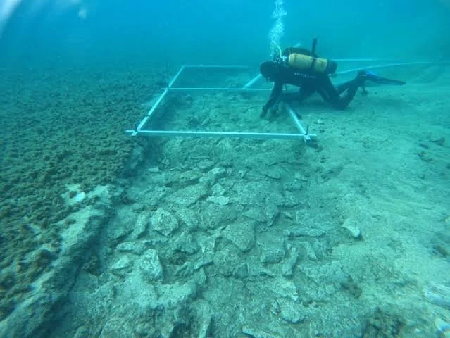
Investigating submerged stone and timber structures in landscapes transformed by rising seas, and asking whether they served as pathways, working platforms, or places of gathering.
Introduction: Archaeology Beneath the Modern Shoreline
Northern Europe's coastlines have changed dramatically since the Neolithic period. After the last glacial period, melting ice sheets and changing ocean levels reshaped bays, estuaries, wetlands, and coastal plains. In some regions, land also rose as the Earth's crust responded to the removal of glacial ice.
As a result, places that were once dry land or shallow wetlands may now lie beneath the sea. Archaeologists investigating these submerged landscapes encounter evidence of settlement, fishing, hunting, transport, and other activities that are difficult to reconstruct from modern coastlines alone.
Among the features that attract attention are stone alignments, timber structures, platforms, and causeway-like formations. Some may represent deliberate construction, while others could result from natural processes or later disturbance.
The title's idea of “causeways to the sea” is therefore a useful hypothesis, not a universal explanation for submerged platforms. Establishing the function of a particular structure requires evidence of human construction, secure dating, and a convincing relationship between its form and the surrounding landscape.
Reconstructing the Neolithic Coastline
The first task is to understand the landscape as it existed when the structure was built. Modern sea level is not a reliable guide to the position of the ancient shoreline.
Researchers reconstruct former coastlines using geological cores, sediment analysis, sea-level models, and evidence of glacial and postglacial landscape change. Peat deposits, submerged soils, ancient river channels, and former wetlands can help identify environments that existed before inundation.
Regional differences are important. In parts of northern Europe, relative sea level rose substantially during the early Holocene, while other regions experienced significant land uplift following glaciation. These processes affected the timing and extent of coastal submergence differently.
The date of a structure must therefore be considered alongside local sea-level history. A platform now underwater might have been constructed on dry land, in a tidal zone, or at the edge of a lagoon. Each possibility implies different functions and patterns of use.
Identifying Human-Made Platforms and Causeways
Submerged archaeological structures can be difficult to identify because currents, sediment movement, and marine growth alter their appearance. Stone arrangements may become scattered, while timber can decay or become buried beneath sediment.
Researchers use underwater survey methods such as side-scan sonar, multibeam bathymetry, photogrammetry, and direct diving inspection where conditions permit. These techniques help document shape, elevation, orientation, and relationships with nearby features.
A platform may be indicated by a relatively level surface supported by stones or timber, while a causeway may form a linear route across a wet or shallow area. Yet natural bedrock, glacial deposits, and wave action can create misleading patterns.
Evidence of construction can include repeated structural units, deliberately placed stones, worked timber, joints, or a consistent arrangement that differs from the local geology. Excavation and sediment analysis can clarify whether the feature was built, modified, or naturally formed.
Researchers should also consider whether a structure was created in one phase or developed through repeated additions. A feature that appears uniform in a modern survey may contain several construction episodes separated by substantial periods.
Possible Functions: Access, Fishing, Gathering, and Ritual
A causeway could have provided access across wet ground, tidal flats, or shallow water. A platform might have supported fishing, the handling of boats, the processing of resources, or other activities that benefited from a stable working surface near the water.
The structure's location can help test these possibilities. A feature connecting two areas of former dry land may have served as a route, while a platform near a sheltered inlet might have supported boat-related activities. However, the surrounding landscape must be reconstructed before such relationships can be established.
Some submerged structures have also been interpreted as ceremonial or gathering places. Such an interpretation requires evidence beyond an unusual location. Deposits of selected objects, repeated structured activity, or a meaningful relationship with other archaeological features may support a ritual hypothesis.
These functions are not necessarily mutually exclusive. A route or working platform could also have held social significance. Archaeologists should therefore distinguish the physical use of a structure from the meanings that people may have attached to it.
Dating Submerged Structures
Reliable dating is essential because a structure may have been submerged long after it was constructed. Timber can sometimes be dated using dendrochronology, while suitable organic material may be radiocarbon dated.
However, a dated object found near a structure does not automatically date the structure itself. It might have been deposited before construction, moved by currents, or introduced during later activity.
Researchers therefore seek direct relationships between dated materials and the construction phase. Timber incorporated into a structure may provide stronger evidence than loose wood recovered from nearby sediment, although reuse and preservation conditions must still be considered.
Radiocarbon dates also require careful interpretation. Marine organisms may produce apparent ages affected by the marine reservoir effect, while freshwater and terrestrial samples have different dating considerations. Appropriate calibration and contextual analysis are essential.
Multiple dates from well-documented contexts can help establish whether the platform was constructed, modified, and abandoned during distinct periods.
What Submerged Platforms Reveal About Neolithic Communities
If a structure is confirmed as human-made, it may reveal how Neolithic communities adapted to changing coastal environments. Its construction could indicate knowledge of local materials, water conditions, and the movement of people and resources through wetlands or shallow marine areas.
A platform near a former settlement might have supported subsistence activities or access to coastal resources. A structure in a more exposed location could indicate a different relationship with the sea, although the ancient shoreline and water depth must be reconstructed before drawing conclusions.
Submerged archaeology can also challenge settlement maps based entirely on modern land. Sites now underwater may once have occupied attractive locations near freshwater, fish, shellfish, and transport routes. Their disappearance from the visible landscape can create an incomplete picture of prehistoric settlement patterns.
Preservation is uneven, however. Some materials survive because they were rapidly buried in waterlogged sediment, while others disappear. The distribution of known sites therefore reflects both ancient behavior and the modern conditions under which archaeological remains are preserved and discovered.
Protecting a Fragile Underwater Record
Submerged Neolithic sites face threats from coastal development, dredging, fishing gear, erosion, and changes in marine conditions. Once exposed, timber and other organic remains may deteriorate rapidly.
Archaeologists and heritage authorities must decide whether a site should be excavated, monitored, or left in place. Excavation can provide valuable information, but it also exposes fragile material and creates long-term conservation responsibilities.
Detailed mapping, environmental monitoring, and non-invasive survey can sometimes preserve knowledge of a site without requiring extensive removal. Public communication is also important because submerged archaeological landscapes may lie outside the familiar boundaries of terrestrial heritage protection.
Conclusion: Recovering Landscapes Lost to the Sea
Submerged platforms and causeway-like structures in northern Europe offer a way to investigate Neolithic relationships with coastlines that no longer exist in their original form.
Their interpretation depends on reconstructing ancient sea levels, confirming human construction, establishing secure dates, and testing possible functions against the surrounding landscape. A submerged feature should not be called a causeway merely because it forms a line beneath modern water.
When these methods are combined, underwater archaeology can reveal how people moved through coastal wetlands, used marine resources, and adapted to changing shorelines. The sea does not simply conceal the archaeological record; it preserves fragments of landscapes whose original geography must be reconstructed before their human history can be understood.