In Germany's 'Stonehenge', A Discovery Sheds Light On 4,000-Year-Old Beer Making

An ancient brewery dating back to more than 4,000 years ago has been unearthed in German 'Stonehenge'.

Excavations have been going on at the site for the last five years. (Representational Photo)

An ancient brewery dating back to more than 4,000 years ago has been unearthed in German 'Stonehenge', a site resembling the original one in the UK with its concentric circles and wooden or stone structures, Newsweek said in a report. The discovery took place earlier this month at the Ring Sanctuary of Poemmelte in the Salzland region of the state of Saxony-Anhalt, and is believed to be central Germany's first brewery, the outlet further said in its report.

Excavations have been going on at the site for the last five years and more than 10,000 discoveries have been made. It will be complete in September 2022.

"The remains of a special drying oven still contain grain residues, from which malt was possibly obtained for an early form of beer production," Dr Franziska Knoll, from the State Office for Monument Preservation and Archaeology of Saxony-Anhalt, was quoted as saying by Newsweek.

"To be absolutely sure, we still have to wait for the archaeobotanical analysis," she added.

But the barley and malt obtained from the excavation site gave another German professor, 62-year-old Harald Meller, confidence that people who descended from eastern Barbarians (around 2,400 BC) had nearly perfected the art of making ale.

"It is quite possible that we will come across the first mug from which the beer was served," Professor Meller was quoted as saying by the outlet.

Dr Gunnar Schellenberger, the president of the State Parliament of Saxony-Anhalt, welcomed the discovery, saying it will help develop interest about the region in tourists.

The Ring Sanctuary, located over 130 kilometres from Germany's capital Berlin, was reconstructed in 2016 and since then has become a popular tourist attraction.

Source: https://www.ndtv.com/world-news/in-germany...

New DNA analysis shed light to Indo-European homeland

Credit: PeopleOfAr


BY THE ARCHAEOLOGIST EDITOR GROUP


Detailed paleogenetic research sheds light on Southern Arc migration, farming, and language evolution.

In a trio of papers, published simultaneously in the journal Science, Ron Pinhasi from the Department of Evolutionary Anthropology and Human Evolution and Archaeological Sciences (HEAS) at the University of Vienna and Songül Alpaslan-Roodenberg from the University of Vienna and Harvard University, Iosif Lazaridis and David Reich at Harvard University—together with 202 co-authors—report a massive effort of genome-wide sequencing from 727 distinct ancient individuals with which it was possible to test longstanding archaeological, genetic and linguistic hypotheses. They present a systematic picture of the interlinked histories of peoples across the Southern Arc Region from the origins of agriculture, to late medieval times.

Credit: University of Vienna

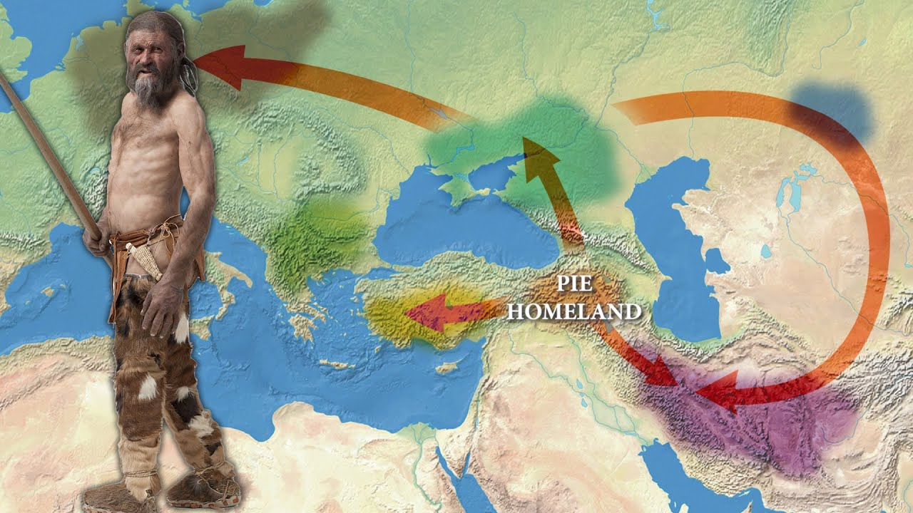
The first article by the international team looked at the origins and dissemination of Indo-European and Anatolian languages. The Indo-Anatolian language family's ancestral home is thought to have been in West Asia, according to genetic evidence, with secondary dispersals of non-Anatolian Indo-Europeans from the Eurasian steppe. People with Caucasian origin came into Anatolia in the west and the steppe in the north during the first stage, which took place between 7,000 and 5,000 years ago. These people may have spoken Anatolian and Indo-European languages in their ancestry.

Around 5,000 years ago, Yamnaya steppe herders with Caucasus hunter-gatherer and Eastern hunter-gatherer heritage set off a series of migrations across Eurasia that may be traced to all currently spoken Indo-European languages (such as Greek, Armenian, and Sanskrit). Their southern excursions into the Balkans and Greece, as well as their eastern expansions across the Caucasus into Armenia, left a mark on the region's Bronze Age inhabitants.

The Yamnaya herders' descendants mixed differently with the local people as they grew. Several types of genetic evidence can be used to pinpoint how Indo-European-speaking immigrants from the steppe interacted with locals to create the Greek, Paleo-Balkan, and Albanian (Indo-European) languages in Southeastern Europe and the Armenian language in West Asia. The Yamnaya had a significant influence on Southeastern Europe, as individuals with nearly pure Yamnaya heritage arrived shortly after the Yamnaya migrations began.

The Southern Arc's Anatolia core region, where large-scale data offers a rich picture of change—and lack of change—over time, yields some of the most startling findings. According to the findings, Anatolia was not significantly affected by the Yamnaya migrations, in contrast to the Balkans and the Caucasus. Due to the absence of Eastern hunter-gatherer ancestors in Anatolia, in contrast to all other places where Indo-European languages were spoken, no connection to the steppe can be established for speakers of Anatolian languages (such as Hittite and Luwian).

The southern Caucasus was impacted numerous times, even before the Yamnaya migrations, in contrast to Anatolia's startling impermeability to steppe migrations. "I was surprised to learn that the Areni Chalcolithic people, who were discovered 15 years ago in the excavation I co-led, had ancestry from gene flow from the north to areas of the southern Caucasus more than 1,000 years before the Yamnaya expanded, and that this northern influence would disappear in the area before reappearing a few thousand years later. This demonstrates that there is still a lot of information to be learned through new digs and fieldwork in Eastern Western Asia "Ron Pinhasi says.

"Anatolia was home to varied communities descending from both local hunter-gatherers and eastern populations of the Caucasus, Mesopotamia, and the Levant," states Songül Alpaslan-Roodenberg

"Variations of the same types of ancestry were shared by the inhabitants of the Marmara region, Southeastern Anatolia, the Black Sea, and the Aegean regions."

Credit: University of Vienna

The interconnections of the first farming societies

The second research project investigates the origins of the world's oldest Neolithic populations, which date to around 12,000 years ago. "The genetic findings support the idea that early farming groups had a network of pan-regional relationships. In addition, they offer fresh proof that the Neolithic transition was a difficult process that took place not just in one central region but also in Anatolia and the Near East, "Ron Pinhasi said.

It gives the first ancient DNA data for Pre-Pottery Neolithic farmers from the Tigris side of northern Mesopotamia, which is a critical region for the origins of agriculture and can be found in both eastern Turkey and northern Iraq. The island of Cyprus, which saw the earliest maritime migration of farmers from the eastern Mediterranean, also contains the first ancient DNA from Pre-Pottery farmers. Together with the first information from Neolithic Armenia, it also offers fresh information on early Neolithic farmers from the Northwest Zagros.

By filling in these gaps, the authors were able to examine the genetic history of these societies, for which archaeological research had previously documented intricate economic and cultural interactions but was unable to track mating practices or interactions that did not leave visible material traces. The findings demonstrate pre-Neolithic roots from hunter-gatherers in the Caucasus, Levant, and Anatolia, and they demonstrate that these early farming cultures created a continuity of lineage that mirrored the topography of West Asia. The findings also show at least two waves of migration from the Fertile Crescent's core to Anatolia's ancient farmers.

The historic period

The third piece demonstrates how ancient Mediterranean political systems maintained differences in lineage from the Bronze Age while remaining connected by migration. The findings indicate that while Italians before the Imperial period had a totally diverse distribution, the ancestry of those who resided in and around Rome during the Imperial period was nearly identical to that of Roman and Byzantine inhabitants from Anatolia. This shows that the heterogeneous but comparable population of the Roman Empire, both in its longer-lasting eastern component focused on Anatolia and in its shorter-lasting western part, was plausible drawn to a significant extent from Anatolian pre-Imperial sources.

"Our findings are rather unexpected considering that in a Science study I co-authored in 2019 on the genetic heritage of people from Ancient Rome, we discovered a cosmopolitan pattern that we initially believed to be specific to Rome. Now that we can see it, other parts of the Roman Empire were just as multicultural as Rome itself, "Ron Pinhasi argues.

Iceland’s ancient caves reveal the island’s Viking early history

‘My grandfather told me the history of the caves that his grandfather told him,’ Baldur Thorhallsson said. ‘Tourists love those stories as well’

Gustaf Skarsgard as Floki in the TV series Vikings, in front of a waterfall in Iceland where the show was filmed. The enduring fascinating with Viking history is a boon to Iceland’s tourist industry (Photo: Arnaldur Halldarsson/History)

South Iceland is home to some of the country’s most jaw-dropping scenery – wondrous waterfalls, vast glaciers and sweeping black sand beaches. But the region is also full of Viking history, including recently discovered ruins dating from the 10th century.

Vikings from Scandinavia and the British Isles descended on Iceland in the ninth century, enduring volcanic eruptions, harsh winters and famine. Iceland’s early settlers built extensive cave systems to survive, some of which are just now seeing the light of day after centuries buried in the earth.

Excavations of man-made, Viking-era caves near Oddi in the country’s south have revealed an extensive system of interconnected structures much larger and older than initially thought. Archaeologists say the excavations show that the caves at Oddi were first dug out in the middle of the 10th century.

Excavations of caves in Iceland have provided new insight into the remote island’s early history (Photo: Supplied)

Kristborg Þórsdóttir, of the Archaeological Institute of Iceland who is leading the excavation, said one of the best known clan members was Sæmundur fróði (Sæmundur the Learned) who lived from 1056 to 1133 .
A key figure in Icelandic folklore, the scholar and priest founded the school at Oddi and was known as the most educated man in Iceland.

“He was sent to central Europe to study, and when he returned, he became a prominent figure in society and is believed to have written some of the earliest literary works in Iceland,” she said.

He also came to be mythologised as a man who managed to trick the devil. In one story, he was at a school for the black arts, where the devil had the right to take the last student of each group. But when Sæmundur trailed behind his companions and the devil went to seize him, he said, “I am not the last. Do you not see who follows me?” He pointed at his shadow which the devil tried to snatch, allowing Sæmundur to flee.

In addition to becoming the centre of Viking power and influence, Oddi was also a hotspot for culture and learning. The writer Snorri Sturluson was fostered there by Jón Loftsson (Sæmundur’s grandson). Sturluson (1179-1241AD) was one of the most significant figures in Iceland’s history: a chieftain, storyteller, politician and literary figure, credited with many of Iceland’s most important literary works of the Middle Ages, including Egil’s Saga.

Ms Þórsdóttir said the Oddi excavations have revealed the oldest dated example of a man-made cave in Iceland. They have been dated by aligning the layers of ash and volcanic debris with the known dates of eruptions.

“The fact that the cave in Oddi seems to have been dug out in the 10th century makes it a Viking age structure, adding to our previous knowledge of the building techniques of the first settlers in Iceland and of the people of the North Atlantic,” she said.

“Our research shows that the making and use of man-made caves in Iceland was widespread and started earlier than was previously known. From our experience in Oddi, [we believe] there are many structures of this type that have been sealed off and forgotten.

“We hope to be able to continue the excavation to get a better idea of how long these caves were in use, how their use changed over time and if there are any indications of people living in parts of the cave system,” she said.

Among the discoveries is a cave that may have been used to protect cattle and horses. Such stalls were known as nautahellirs and feature in the 13th century book Legends of Saints by Bishop Þorlákur, in which a cave collapse was recorded.

Collapses are also a risk for archaeologists. The caves are cut into sandstone which absorbs water and is prone to crumbling.

Discoveries in the caves bring new context to saga stories and oral history passed down in the country (Photo: Supplied)

But the find is expected to become a major tourist drawcard.

The country has numerous other Viking-era sites that range from the historic to the kitschy. The Caves of Hella on the south coast is a popular attraction and the site of 12 man-made caves. Four were opened to the public in 2019, and the site is one of Iceland’s oldest standing archaeological remains.

Elsewhere, the Skógar Museum features many Viking artefacts, and Skyrland introduces visitors to the 1,000-year-old story of how a Viking dairy product (skyr) became a global health food. Nearby, Ingólfsskáli restaurant gives travellers the chance to experience Viking feasts with a contemporary touch.

Locals are optimistic that the discovery could cement Oddi’s place in the history books. Baldur Thorhallsson, whose family has been taking care of the Caves of Hella for nearly 200 years, said it was a positive development.

“I’m a teacher, and I know that Icelanders love to hear a good story and caves are a great story,” said Mr Thorhallsson.

“My grandfather told me the history of the caves in Hella that his grandfather told him. Tourists love those stories as well.”

Source: https://inews.co.uk/news/world/iceland-anc...

Medieval map may show evidence of Wales’ "Lost Atlantis"

Islands may have been flooded by rising seas after the last Ice Age, according to researchers.

A Swansea researcher has suggested that a medieval map of two islands off the coasts of Ceredigion and Gwynedd may be proof of the fabled lost kingdom of Cantre'r Gwaelod.

One additional island is depicted on the Gough Map between Aberystwyth and Aberdyfi, according to the analysis published in Atlantic Geoscience, while another is off Barmouth to the north.

David Willis, the Jesus Professor of Celtic at the University of Oxford, and Simon Haslett, an honorary professor of physical geography at Swansea University, collaborated on the discovery.

The narrative of Cantre'r Gwaelod describes a territory that was flooded after Seithenyn, the gatekeeper who kept the sea out, went to a celebration, got wasted, and failed to shut the gate.

The myth may have begun in Scotland or Northumbria and eventually spread to Wales, according to some academics who have connected the tale to the Old North.

The Gough Map of Great Britain

Yet, according to Simon Haslett and David Willis' research, there may be two "lost" islands in Cardigan Bay, off the coast of west Wales, United Kingdom.

Their research examines historical documents as well as geological and bathymetric data, and they suggest that post-glacial coastline evolution can explain the "lost" islands.

They contend that by the 16th century, the two surviving islands may have been gone due to erosion and an increase in sea levels.

They claim that Cardigan Bay is connected to the 'lost' lowland of Cantre'r Gwaelod thanks to literary evidence and folklore tales.

The model has the potential to shed further light on the post-glacial history of lowlands similar to those found around the northwest European coasts.

According to Simon Haslett, the map suggests that certain landforms may have been lost in Cardigan Bay's shallow waters.

According to Simon Haslett, who spoke to the BBC, "The Gough Map is incredibly accurate considering the surveying equipment they would have had at that time."

The two islands are clearly identified, which could support reports from the time that a lost land was referenced in the Black Book of Carmarthen.

Cantref Gwaelod? The image has been rotated so that north is up

The first comprehensive map of the British Isles that has survived dates to the middle of the thirteenth century and is kept at the Bodleian Library at Oxford University.

"I believe the evidence for the islands, and perhaps as a result, the tales associated with them, is in two threads," Simon Haslett continued.

"First off, Ptolemy's Roman cartographer's coordinates indicate that the shoreline may have extended 13 kilometers (8 miles) farther west than it does now.

"And second, the Gough Map's evidence for the presence of two islands in Cardigan Bay

Suprise medieval double grave found inside circular ditch

Archaeologists have discovered an early medieval double grave at the center of a circular ditch in Kirchheim am Neckar, southern Germany. Two plots of land in an area of Kirchheim designated as a cultural monument were excavated in advance of development. The presence of a burial ground was known since the 19th century (hence the designation), but the discovery of a double grave inside a ring ditch was unprecedented.

The double grave was found at the southwest end of the burial ground. The circular mark on the ground is all that remains of a large tumulus. The burials consist of two adjacent wooden chamber graves built over carved rock. One belonged to a woman; one to a man. The graves had both been looted in antiquity, but the tomb raiders only pillaged from the knees up. The areas below the knees were untouched, and the looters really missed out.

Below the foot of the buried man were a large ornate bone comb, a ceramic pot, silver sheet bands, a glass tumbler, horse bridles and a bronze vessel filled with organic material and animal bone and a large egg-like object beneath a ceramic bowl. A gold coin was also found in the dead man’s mouth as an obolus [, also known as Charon’s obol, a coin to pay for passage to the underworld].

The remains of a decapitated horse were buried just outside the ring ditch. The presence of horse bridles in the man’s grave suggests the horse was a companion burial.

The woman’s burial was richly furnished as well, despite having been looted. Grave goods found in her grave include a pearl necklace, a gold pendant inlaid with almandine garnets, a disc brooch, a weaving sword, scissors, a glass beaker and a chatelaine with a decorative disc and a Cypraea snail shell hanging from it. These were high value objects, jewelry and household goods alike. The Cypraea was imported from the Indian Ocean and was a very expensive charm to hang from a belt.

The excavation of the two properties found 22 more graves, all of them simple inhumations without funerary offerings. These were the kinds of graves archaeologists excepted to find at the site, comparable to the ones discovered there in the past. The occupants of the double grave were set apart in the burial ground, separated from the hoi polloi both in location and in the distinctive grandeur of their burials.

Source: http://www.thehistoryblog.com/archives/649...

Glacier archaeologists find a 1300-year-old arrow in melting ice

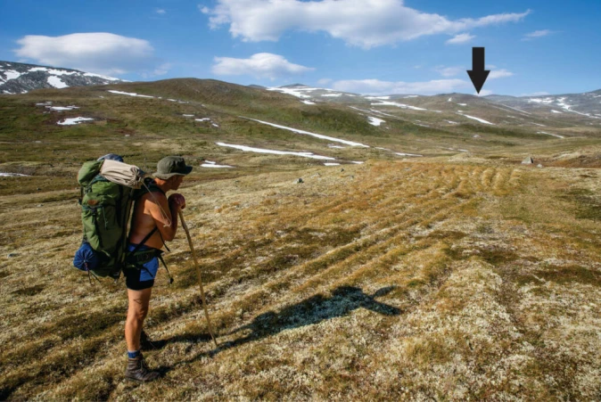
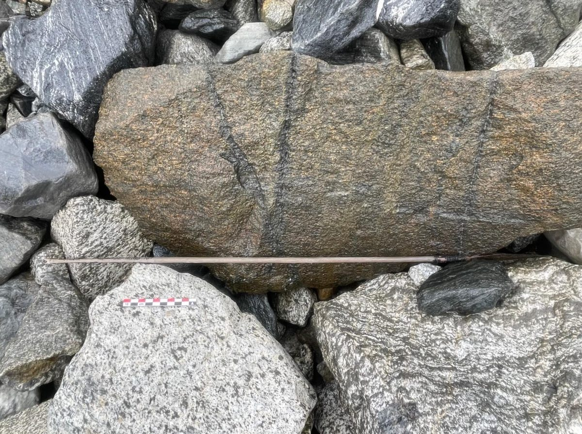
The Glacier archaeologists found a 1300-year-old arrow from the Norwegian Iron Age during a research project on the Langfonne ice patch in the Jotunheimen Mountains in Norway.

In the past twenty years, Langfonne has dramatically retreated. Its current size is less than 30% of what it was 20 years ago. The retreat is evident from the surroundings. The ice is surrounded by bedrock devoid of lichen and moss and is a light gray color. Three distinct ice patches have formed from the split ice. Only 10% of the Little Ice Age’s maximum ice cover remains at Langfonne today (AD 1450-1920). The melting of Langfonne is a part of a much larger global warming-related pattern of retreating mountain glaciers that includes glaciers in Norway and other countries.

However, the Langfonne ice patch is the ice site in the world with the most arrows.

The arrow was discovered in a collection of broken rock fragments between larger stones on the lower edge of the icefield.

The team believes that the arrow was lost and deposited downslope by meltwater and that it has since been exposed several times by melting ice over the centuries.

This is indicated by the lack of fletching, the fin-shaped aerodynamic stabilization normally made from feathers or bark. Evidence of sinew and tar has also been identified, but this survives in a poor state of preservation. The arrow is tapered towards the end and the nock has been thickened for engaging with a bowstring. The remains of the tar would have glued the fletching to the shaft, while imprints of the thread securing the fletching are still visible.

In recent years, the team has found numerous arrows in the region during the Late Neolithic (2400-1750 BC) and especially during the Late Iron Age (AD 550-1050).

The team found another arrow earlier this year in the Jotunheimen mountains which dates from around 1,700 years ago. This arrow was found complete with its iron arrowhead, sinew wrappings, and aerodynamic feather fletching.

The project also discovered the best-preserved example of prehistoric skis, a Bronze Age shoe, and a lost Viking settlement containing sleds, dead animals, clothing, and household items in melting ice patches.

On their Facebook page, you can keep up with the project’s development and updates.

Secret Of the Ice

Source: https://arkeonews.net/glacier-archaeologis...

Rare Neolithic, Migration Period graves found near Danube

Rare graves from the Neolithic and early medieval Migration Period have been discovered in Tuttlingen, in southwestern Germany near the Danube Sinkhole. A preventative archaeology excavation at the site of a planned rainwater retention basin unearthed a Stone Age grave of the Corded Ware culture containing grave goods including a characteristic pot of the type that gave the culture its name, and dozens of Migration Period graves containing weapons and jewelry.

Only one Neolithic grave has been found so far — Corded Ware culture graves are rare in southwestern Germany — but archaeologists did discover the remains of a prehistoric settlement. The grave contained a corded ware beaker, decorated at the neck by winding a rope around it when the clay was still wet to create a dimpled effect.  It also contained a stone axe with a neat hole in the middle where the handle was once mounted and a flint blade. The Corded Ware grave dates to the 3rd millennium B.C.

The Migration Period cemetery is large with about 140 burials, and many of them are richly furnished. This was a period of mass movement of people throughout Europe in the wake of the collapse of Roman power. They usually travelled in tribes of about 10,000-20,000 lead by a warlord until they found a place they wanted to settle. The cemetery dates to the later Migration Period.

“Most burials contain grave goods such as weapons, e.g. swords, lances, shields, and jewelry such as glass beads, earrings, belts or belt pendants,” said Dr. Andreas Haasis-Berner, responsible area officer at LAD, today (August 18, 2022) presenting the current results in Gutmadingen together with the excavation company and the city. Bone combs or a drinking glass are special features. Based on these grave goods, the burial ground can be dated to the 6th century.

This entry was posted on Friday, August 19th, 2022 at 11:53 PM and is filed under Ancient. You can follow any responses to this entry through the RSS 2.0 feed. You can skip to the end and leave a response. Pinging is currently not allowed.

Prehistoric people in the UK used rare crystals to mark burial sites

They were transported long distances and were considered highly valuable

Image credit: The researchers.

Archaeologists from the University of Manchester discovered rock crystals during excavations at Dorstone Hill in England — a monumental complex from the Neolithic Period (6,000 BC to 3,000 BC). The crystals were brought to the site and knapped in a systematic way to mark burial sites and were then deposited in the Neolithic burial site.

The complex, excavated between 2011 and 2019, includes three long mounds, three timer halls and a causewayed enclosure. As well as a wide array of artefacts such as pottery, stone implements and cremated bones, the researchers uncovered rock crystal – a pure, transparent form of quartz, which forms in large six-sided crystals. By far, the quartz is the most striking find from the site.

While evidence for the use of rock crystal has been found at other prehistoric sites in the United Kingdom, only a few studies have specifically looked at how the material was used and its potential significance. Now, the team at the University of Manchester has suggested the crystals were intentionally deposited within the burial mounds.

“It was highly exciting to find the crystal because it is exceptionally rare – in a time before glass, these pieces of perfectly transparent solid material must have been really distinctive,” lead author Nick Overton said in a statement. “I was very interested to discover where the material came from, and how people might have worked and used it.”

A close look at rock crystals

People at Dorstone Hill had a lasting association with rock crystal, the researchers said. It was transported large distances to the site and worked in a systematic manner that remained a feature of local practice for generations. But it wasn’t used in any utilitarian way, it was intentionally collected and deposited in burial mounds with other artifacts and materials.

Based on the local geology, the rock crystal could have originated from a very limited number of sources, all of which are far away from the site. The researchers believe that the most likely sources are Snowdonia in north Wales or St David’s Head in southwest Wales. The material could have been used by people to demonstrate their local identities and connections with other places, they said, or could have had some spiritual meaning.

“The crystals would have looked very unusual in comparison to other stones they used, and are extremely distinctive as they emit light when hit or rubbed together and produce small patches of rainbow,” Overton said in a statement. “They would have created memorable moments that brought individuals together and forged local identities.”

One of the crystals, for example, has a small internal structure that is illuminated by a rainbow flash when rocked back and forth in the light. Another piece, a flake full of micro-cracks, shimmers with dancing lines of a rainbow as light hits the internal fracture planes within it. This added an extra dimension to the “visually arresting” character of this material.

As well as in Dorstone Hill, crystals have played a significant role in people’s lives in a large number of societies, the researchers said. Animist groups in the Amazon saw quartz as a “living rock” with special healing properties and Australian aboriginal groups understood rock crystal as “solidified light,” spiritually charged with power, for example.

“At Dorstone Hill, the working of this material, associated with dramatic places, and affording experiences of its unique transparent, refractive and triboluminescent properties, would act to disrupt everyday life, creating memorable moments for those in attendance,” the researchers wrote.

Up next, the team hopes to study materials found at other sites in the UK to discover whether people were working with this material in other ways, as well as to uncover connections and local traditions. They also want to analyze the chemical composition of the crystal to find out if they can track down its specific source.

The study was published in the Cambridge Archaeological Journal.

Source: https://www.zmescience.com/science/prehist...

Prehistoric 5,000-year-old 'Penang Woman' finally has a face

GEORGE TOWN: Five years after researchers from Universiti Sains Malaysia (USM) found a prehistoric human skeleton, dubbed the "Penang Woman", believed to be at least 5,000 years old, they scored another major breakthrough.

This time around, the same researchers have put a face to the Penang Woman using the Forensic Facial Approximation method.

The skeleton was found during the construction of a gallery for the Guar Kepah neolithic site in Kepala Batas in 2017.

With the help of Cicero Moraes, a 3D graphics expert from Brazil, they used the 3D virtual reconstruction method to create the Penang Woman's facial features based on a scientific date obtained from a CT scan performed on the skeleton.

The same team was also instrumental in reconstructing the facial features for the more than 10,000-year-old "Perak Man" using the same method last year.

Shaiful Idzwan Shahidan, the team's correspondent author, said they took between three and four months to come out with the facial features, which was completed on July 5.

A paper, titled "Forensic Facial Approximation of 5000-Year-Old Female Skull from Shell Midden in Guar Kepah, Malaysia", was published in the Journal of Applied Sciences on Aug 5.

Shaiful said when they found the skeleton back in 2017, one of their objectives was to conduct a more in-depth study about the life of the Penang Woman.

© Provided by New Straits TimesPrehistoric 5,000-year-old 'Penang Woman' finally has a face

"We were curious to know how the Penang Woman really looked back then. From the facial features, we can tell that Penang Woman is possibly a mixture between the Australomelanesoid and Mongoloids.

"It is likely that the Guar Kepah population then was a mixture of the Australomelanesian and Mongoloid races," he said.

Shaiful, however, said a more detailed study could be conducted if Malaysia brought back the 41 skeletons from three shell middens in Guar Kepah, which were excavated by British archaeologists between 1851 and 1934 and currently at the National Natuurhistorisch Museum in Leiden, Holland.

When the Penang Woman skeleton was found in April 2017, researchers came across a skull, a femur bone and a rib cage beneath the floor of a house which had been demolished to make way for the gallery.

The skeletal remains were the first and only remaining Neolithic skeleton found in a shell midden in Malaysia. Shell middens refer to mounds of kitchen debris consisting mostly of shells and other food remnants and indicate ancient human settlement and sometimes used as burial sites.

The remains were discovered in shell midden C with her arms folded and surrounded by pottery, stone tools and several type of shells, a sign of her important position in her society.

In total, 41 skeletons from three shell middens, identified as A, B and C in Guar Kepah, were excavated by British archaeologists between 1851 and 1934 and those skeletons are now at the National Natuurhistorisch Museum in Leiden, Holland.

The original Penang Woman is being carefully conserved in USM as it had to be in a temperature and humidity controlled environment, which meant the skeleton currently showcased at the gallery is a replica of the original.

© New Straits Times Press (M) Bhd