Introduction
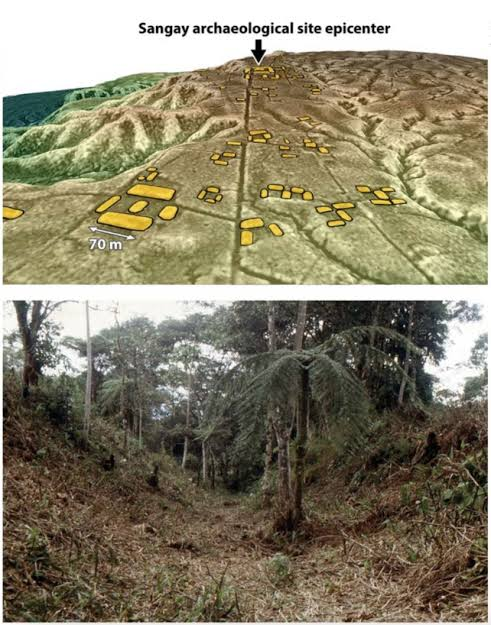
Located in the shadow of the active Sangay Volcano in eastern Ecuador, the Upano Valley within Sangay National Park contains the oldest and largest urban network ever discovered in the Amazon. First identified through ground surveys and fully mapped using airborne LiDAR by archaeologist Stéphen Rostain, the site reveals a vast, garden-city urban landscape that flourished from 500 BCE to 600 CE—predating known complex Amazonian urban centers by over a thousand years.
Urban Layout and Infrastructure Engineering
The Upano Valley urban complex was built using massive earthmoving technology, transforming the volcanic landscape into organized civic centers:
Earthen Mound Platforms (Tolas): Over 6,000 rectangular earthen platforms (typically 20m x 10m and 2–3m high) were constructed around central plazas. These platforms supported timber residential structures, ceremonial halls, and processing areas.
Sunken Road Networks: The city centers were linked by an incredible network of wide, straight, sunken roads excavated deep into the volcanic soil, extending over tens of kilometers.
Agricultural Terracing & Drainage: The slopes between platform complexes were systematically terraced and fitted with deep drainage channels to manage heavy tropical rainfall and control runoff from the nearby Sangay Volcano.
This urban civilization was supported by intensive agriculture, cultivating maize, sweet potato, manioc, and beans in rich soils fertilized by periodic volcanic ash falls.
Conclusion
The Upano Valley discoveries in Sangay Park fundamentally redefine the timeline of South American urbanism. They prove that complex, densely populated, road-linked cities existed in the Amazon basin over two thousand years ago.