
The islets located to the south and west of the coast of Messinia in Greece are not well known to the public, but they hide their own surprises, with Sapienza being the most typical example among them.
Sapienza belongs to the so-called Messinian Oinousses and is located off the southwest coast of Messinia, directly opposite Methoni, near the deepest point of the Mediterranean. No one lives there anymore.

The heart-shaped islet near the lighthouse of Sapienza
Sapienza is located on a maritime route which, since ancient times, was of great commercial and strategic interest, as it connected Italy with the Middle East. At the same time, however, it was also a difficult area, full of strong sea currents, strong winds and difficult rocks. As a result, several shipwrecks occurred on the coasts and off the island, some of which are considered important from an archaeological point of view.
The exceptional findings found in them make the Methoni marine area one of the most important underwater archaeological sites.
The latest sea surveys in the bay of Methoni and the island of Sapienza in Messinia have brought to light unknown wrecks that have been lying on the seabed for hundreds of years, while both known wrecks on the northern shores of the island of Sapienza have been mapped in detail for the first time.
Geoarchaeological investigations were also carried out in the submerged settlement of the Middle Bronze Age that has been identified in the bay of Methoni.

The identified shipwrecks belong to the most recent times and one to the era of the Turkish occupation.
The scanner even showed "metallic targets", probably cannons. The findings will be examined in detail in the future.
The two shipwrecks (along with a third, older one) were found on top of the Bronze Age settlement, part of which is buried under the bottom sand and is ultimately larger than archaeologists had previously thought.
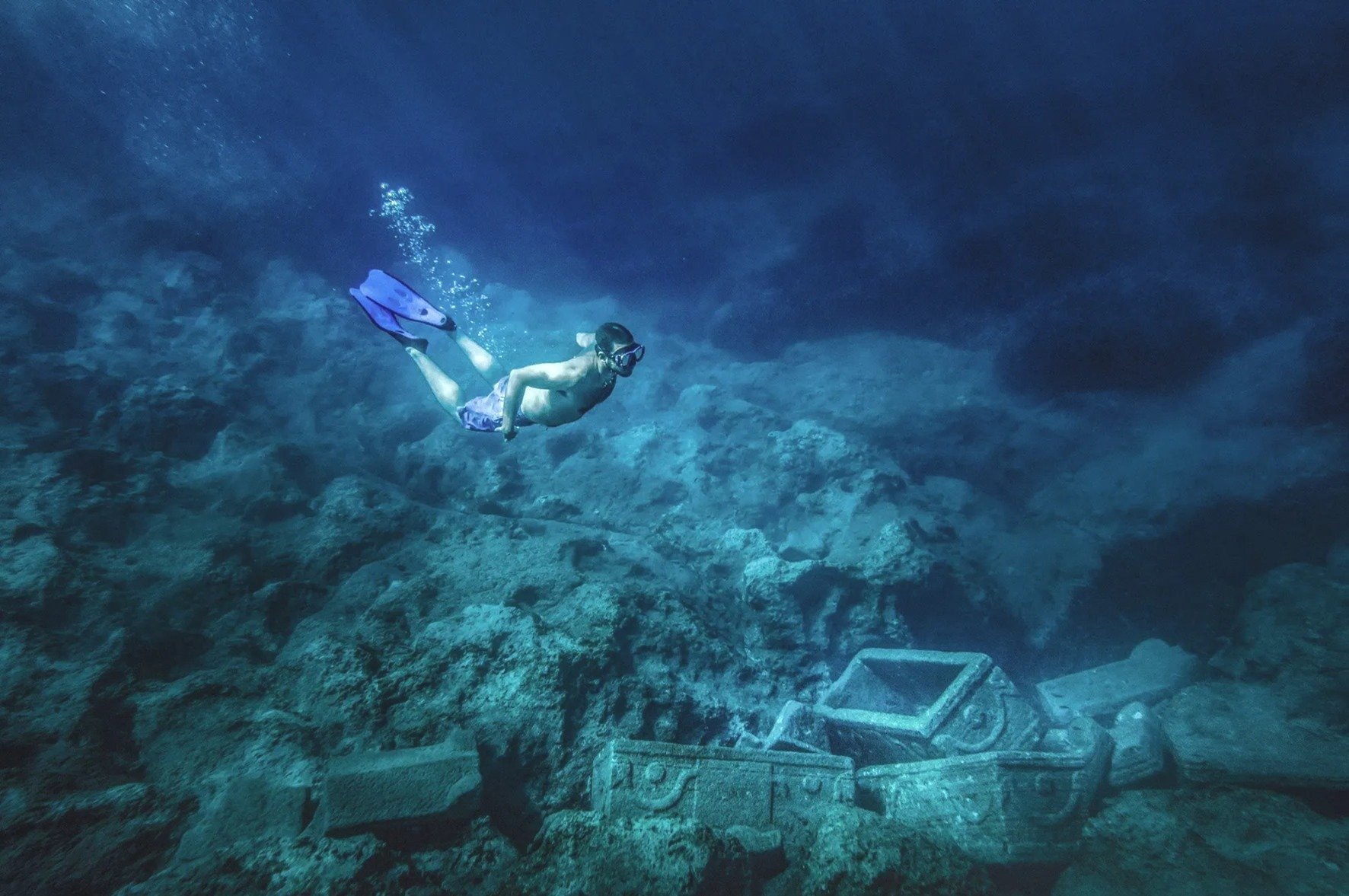
Shipwreck of Sarcophagi
On the neighboring islet of Sapienza, on its northern shores, the two known shipwrecks of Roman times were captured in detail for the first time.
The first is known as the Shipwreck of Sarcophagi because it carried stone sarcophagi. The shipwreck is lying at a depth of 15 m. ts cargo contains a number of stone sarcophagi including their covers. The sarcophagi are intact except for one, which probably ruined when the ship sunk. The sarcophagi measures 2.20 x 0.80 m.
The sarcophagi bear reliefs; their decoration is simple containing floral motifs, boukranion etc. The covers are curved with simple, shaped decoration at the edges. The shipwreck is dated to the 3rd century AD.


Shipwreck of columns
The second is called Shipwreck of Columns because there were some columns made of red granite.
Around 1920, local fishermen located archaeological finds lying on the seabed close to the northern cape of Sapienza (Cape Karsi), opposite the village of Methoni.
In 1925, the lawyer and historian Dionisios Potaris (1860–1922), following fishermen's indications, located and recorded the ‘marbles’, in a distance of 50–60 m from the northern shore of Sapienza and in a depth of 6-7 m. He correctly assumed that the pile of marbles was actually a shipwreck transferring antiquities.

The ‘shipwreck of columns’ lies at a depth of 10 m, close to Cape Spitha. The columns are scattered over an area of 30 m2 and are 10 m away from the edge of the Cape. Parts of the columns are aligned and situated at the seabed, while other parts are scattered in a wider area around them.
34 fragmented, plain, single stone columns were located. Only one of them is intact, with a height of 8 m and diameter of 0.90 m. 28 parts of the columns are concentrated, and the remaining 6 are situated at a distance of 60 m from the rest.
The columns are made of reddish granite, similar to the columns positioned in the Fortress of Methoni. The admiral Francesco Bebo positioned this column in 1493/4 in memory of the recovery of the Fortress by the Venetians. Therefore, it is assumed that the ship sank earlier. This particular type of granite exists only in Egypt and in particular areas of Greece (Xanthi, Kavala, and Mykonos Island).

Studies of the column fragments showed that the columns were part of a building containing 16 columns that was demolished or collapsed.
The ship had these columns as part of its cargo. The fragments of the columns are broken irregularly, and they cannot be connected between them. Some of the columns are circular on top, as they were used for tying up the ships close to the ‘mole’.
The results of the geophysical survey are expected to provide important information on the wider location of their sinking.
In fact, in this particular area, it is planned to become an underwater archaeological park in the future.


