How Can we explain these discoveries? They prove the ancient knew about technology that we were told they knew nothing about! While the modern world has made great progress science, all of these achievements had already been done long ago.
Evidence for Ancient Israel Discovered in Egypt
Join Joel as he travels to Egypt to explore one of the most significant discoveries ever made in Biblical archaeology showing evidence for ancient Israel. In 1896, Flinders Petrie discovered a stele ten and a half feet high, five feet wide, inscribed on both sides. What makes this find so significant is the discovery on it of a single word, "Israel."
30 Greatest Man-Made Wonders of the World
The earliest lists of Seven Wonders of the Ancient World were made more than 2,000 years ago by ancient Hellenic tourists. Except for the Great Pyramid of Giza those wonders no longer exist. They were destroyed by earthquakes, fires and in one case by an angry mob. Many other lists of amazing structures have been made since then. Here’s a look at our list of the greatest man-made wonders of the world. Enjoy!
The Entire History of the Phoenicians (2500 - 300 BC)
Before the Greeks and Romans, the Phoenicians ruled the Mediterranean. In the following video we will be exploring the entire history of the Phoenicians. Enjoy!
12 Most Mysterious Archaeological Finds Scientists Still Can't Explain
Where's the fun in solving a problem if all the answers come at once? As human beings, we love a little mystery, and if that mystery comes in the shape of an ancient wonder, it's even better! We know of a few ancient finds that match that description, and we've collected some of the best of them so we can tell you their stories in this video.
Most Puzzling Underwater Ruins Ever Discovered, No One Expected To Find These Ancient Buildings
These submerged ruins have completely changed how we view the ancient world due to their age and the depth at which they were discovered. Right up until they were found no one even believed they could exist. Huge megaliths, massive human made bridges, and the strangest of all...an underwater pyramid city has all been found under the ocean waves. Are they remnants of a pre-ice age civilization, one that became lost to the sands of time?
Weapons Masters Rate 7 Duels in Movies and TV
Medieval-weapons expert Toby Capwell and master-at-arms of the London Longsword Academy Dave Rawlings look at seven duels from movies and TV and rate them based on realism. They discuss the rules and formalities around judicial duels and trials by combat.
Creepiest & Scariest Archaeological Discoveries
In the following video we will be exploring some of the creepiest and scariest archaeological discoveries ever. Watch the video to find out more!
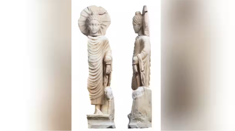
A handout picture released by the Egyptian Ministry of Tourism and Antiquities on April 27, 2023 shows a statue of Buddha uncovered in Egypt's ancient seaport of Berenice, now known as Medinet el Haras, shedding light on the ancient trade ties with India under the Roman empire. Photograph:(AFP)
Shock in Egypt: Buddha statue discovered near the Red Sea
The joint Polish-American archaeological mission, working in the temple of the ancient city of Berenike on the coast of the Red Sea in Egypt, discovered a Buddha statue from the Roman era.
Archaeologists believe that a 1,900-year-old Buddha statue that was found at the ancient Egyptian port city of Berenike on the Red Sea coast belonged to a South Asian immigrant.
Siddhartha Gautama, who lived in South Asia about 2,550 years ago, is shown in the Buddha statue. The Buddha, a term borrowed from Sanskrit and meaning "the enlightened one," according to Buddhist legend, was formerly a prince who later gave up his material wealth and sought enlightenment. He started a new religion, which spread over time.
According to Steven Sidebotham, a history professor at the University of Delaware and co-director of the Berenike Project, the newly discovered monument was created between the years A.D. 90 and 140.
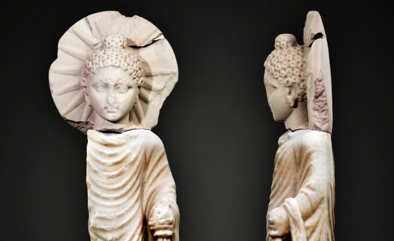
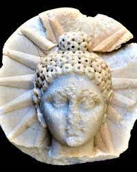
The 71-centimeter-tall (28-inch) statue depicts the Buddha standing and holding a portion of his robes in his left hand, according to a statement from the Egyptian Ministry of Tourism and Antiquities (opens in a new tab). Behind him, sunlight is depicted radiating downward from a halo. The ministry reported that, in addition to the statue, a different Sanskrit inscription was discovered at Berenike.
The statue originates from a time when Egypt was governed by the Roman Empire. According to the ministry, there was a lot of trade between Egypt and India at that time, and ships from India would carry goods like textiles, ivory, and pepper, among other things, to Egypt.
According to Sidebotham, it's probable that residents of Berenike who are from South Asia created the Buddha statue locally. While broken, the Sanskrit inscription looks to be some sort of dedication and dates to the period of the Roman emperor Marcus Julius Philippus, who ruled from A.D. 244 to 249, according to Sidebotham.
He emphasized that further information would be made available following the publication of Sidebotham and his colleagues' findings from Berenike.
The newly discovered Sanskrit inscription and related discoveries, according to Richard Salomon, professor emeritus of Sanskrit at the University of Washington in Seattle who was not involved in the discovery, "now clearly demonstrate that there was a settled Indian merchant community, rather than just traders passing through."
It was "a really thrilling find," according to Philip Almond (opens in a new tab), an emeritus professor at the University of Queensland in Australia's Institute for Advanced Studies in the Humanities who was not involved in the finding. Almond remarked that there were Indians in Alexandria according to ancient historical documents, and this discovery suggests that some of the Indians who lived in Egypt were Buddhists.
Rodney Ast, a researcher at the University of Heidelberg in Germany, and Olaf Kaper, a professor of Egyptology at Leiden University in the Netherlands, are the two co-directors of the Berenike Project. The Polish Center of Mediterranean Archaeology in Cairo received permission from the Egyptian Supreme Council of Antiquities to carry out the project.

The mystery of the collapse of the Indus Valley Civilization has now been solved
THE ARCHAEOLOGIST EDITOR GROUP
Although it is considered one of the world's most ancient civilizations and the subject of extensive research, much about this ancient society remains unknown.
The growing Indus Valley Civilisation presided over the region that is now Pakistan and India four thousand years ago. From 2600 BC to 1500 BC, the Indus Valley Civilisation flourished in the Indian subcontinent near the Indus River. It probably had a profound impact on Hindu culture, according to archeological evidence. This civilization was lost to history until it was rediscovered in 1920. Taking into account the evidence of the appearance of cities, agriculture, architecture, and writing, it is ranked alongside its contemporaries, the Mesopotamian and Egyptian civilizations, as one of the three most ancient civilizations on Earth.Although it is considered one of the oldest civilizations in the world and the subject of extensive research, much about this ancient society remains unknown.

Himalayan cave stalagmite offers most detailed explanation yet of what led to ancient Indus civilization's decline, new study says.
The "social and political structures" of the Indus civilization, for example, are unknown, according to the Encyclopedia Britannica. Archaeologists and historians know almost nothing about the language, the weight system, or the artifacts of the time. Yet one mystery remains the greatest of all: how, when, and why did the Indus Valley Civilization disappear?
Experts generally agree that a drought hit the Indus Valley about 4,200 years ago, but the "exact timing and magnitude" of that drought remain unknown, researchers said in a study published April 4 in the journal Communications Earth & Environment.
The Dharamjali cave in the Himalayas held the solutions to these vexing issues. Researchers discovered a stalagmite with a revealing mix of traits close to the far end of the tiny cave. Although the cave creation occurred in a weather-sensitive environment, it was protected enough to have formed during this prehistoric epoch. According to the study, the researchers were able to reconstruct historical rainfall patterns that started 4,200 years ago based on the stratified strata of minerals in the stalagmite.

Their findings provided a more thorough and slightly different picture of ancient life than what was previously known. The researchers discovered "three big drought periods" between 4,200 and 3,900 years ago, with each one "lasting 25-90 years," as opposed to "a single severe drought spanning roughly 100-200 years." In a press statement on April 24, research co-author Cameron Petrie of the University of Cambridge noted, "We find convincing evidence that this time was not a short-term crisis but a continuous transformation of the natural conditions under which Indus people lived." According to the study, rainfall dropped during these dry spells in both the summer and the winter. The drought had a negative impact on Indian towns' access to water as well as predictions of rainfall and river flooding for crucial crops.

"The archaeological findings show that over a period of 200 years, the ancient inhabitants took various measures to adapt and remain resilient in the face of this new environment," study lead author Alena Gise said in the release. The great megacities of the Indus, such as Harappa, began to decline as people moved to "smaller and more flexible agricultural settlements," as the researchers point out in the study. "Craftsmanship and innovation in Indian urban centers... and long-distance exchange and trade" also declined. About 300 years after the final dry period, about 3,600 years ago, the Indus Valley Civilization disappeared completely, a study suggests.
In order to better comprehend this final stage of decline, the researchers underlined the need of examining various cave formations, according to the report. The Indian Himalayan area of Uttaranchal is home to Dharamjali Cave, which is around 290 miles northeast of New Delhi and close to the borders with Nepal and China.
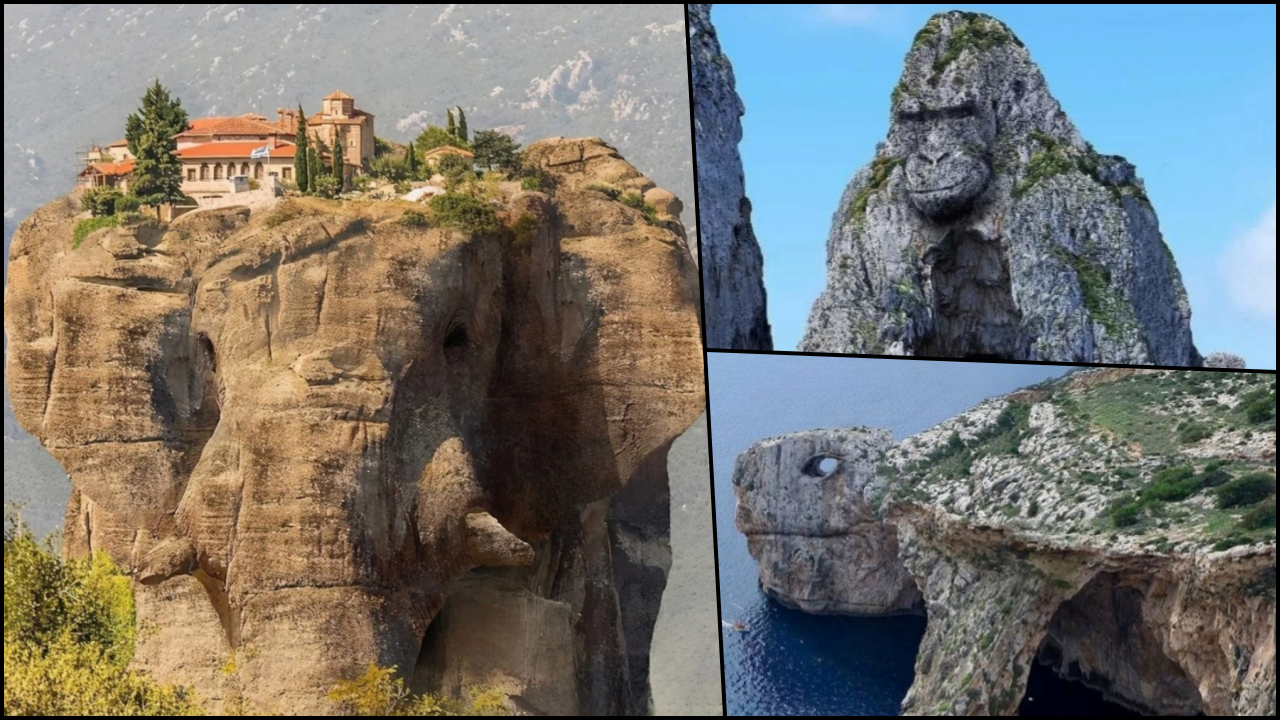
The Enchanting World of Animal-Shaped Rocks: A Journey Through Nature's Artistry and the Role of Fake Viral Photos
THE ARCHAEOLOGIST EDITOR GROUP
The marvels of nature never cease to amaze us, and one such captivating phenomenon is the existence of rocks that appear to take on the shape of animals. These natural formations have long been a subject of fascination, inspiring tales of mythology, spirituality, and human curiosity. However, in the age of the internet, the line between authentic and fake has become increasingly blurred, with countless viral photos of such rocks gaining traction online. In this article, we'll explore some of the most famous animal-shaped rocks worldwide and address the issue of fake viral photos that often misrepresent them.
A Tour Through Nature's Sculptures

Elephant Rock, Iceland: Elephant Rock is a remarkable natural rock formation located near the fishing village of Djúpivogur on the eastern coast of Iceland. This fascinating basalt formation is shaped like an elephant, complete with a long trunk that appears to be dipping into the ocean. The rock's texture resembles an elephant's wrinkled skin, further enhancing the resemblance.
The Elephant Rock was formed over millennia through the process of erosion, as the forces of wind, water, and time sculpted the basalt rock into its current shape. Basalt is a common volcanic rock found in Iceland due to the country's position on the Mid-Atlantic Ridge, which is an active volcanic zone. The formation's striking appearance has attracted photographers, tourists, and nature enthusiasts from around the world.
To reach Elephant Rock, visitors can travel to Djúpivogur, which is about 580 kilometers (360 miles) from Reykjavik, Iceland's capital. Djúpivogur is a small and picturesque village known for its vibrant fishing culture and beautiful landscapes. From the village, travelers can take a short hike to the coast to admire and photograph the Elephant Rock formation.
The Elephant Rock is just one example of Iceland's many unique geological formations that showcase the beauty and diversity of the country's natural landscapes.

Sphinx Rock, Romania: Sphinx Rock is a mysterious and enigmatic natural rock formation located in the Bucegi Mountains of Romania. Situated at an altitude of 2,216 meters (7,270 feet) above sea level, this intriguing formation bears a striking resemblance to the Great Sphinx of Giza in Egypt. The rock measures approximately 8 meters (26 feet) in height and 12 meters (39 feet) in width.
The Sphinx Rock was formed over millennia through the process of erosion, as the forces of wind, water, and time gradually sculpted the limestone into its current shape. The name "Sphinx" was assigned to the rock due to its uncanny resemblance to a human face, specifically the profile view of a human face, complete with a prominent nose and chin.
This natural wonder has been an object of fascination and curiosity for locals and visitors alike, and it has inspired countless legends, myths, and theories about its origin and purpose. Some believe that the Sphinx Rock is a sacred place with spiritual or energetic significance, while others see it as a mere geological coincidence.
To visit the Sphinx Rock, travelers can take a cable car from the town of Bușteni to the Bucegi Plateau, where a short hike leads to the rock formation. The area surrounding the Sphinx Rock offers breathtaking views of the Carpathian Mountains and is popular for hiking, photography, and outdoor activities.
In conclusion, Sphinx Rock is an intriguing natural wonder that adds to the beauty and mystery of Romania's Bucegi Mountains. Its unique shape continues to captivate the imagination of both locals and visitors, inspiring a sense of awe and wonder.

Frog rock | bichane | Flickr
Frog Rock, New Zealand: Frog Rock is an interesting limestone rock formation located in the Waikato region of New Zealand's North Island. The rock earned its name due to its uncanny resemblance to a crouching frog when viewed from certain angles and distances. This fascinating formation is a popular landmark and a favorite spot for photography enthusiasts and tourists alike.
Frog Rock is situated along State Highway 1, between the towns of Oaro and Kaikōura, in the Weka Pass area. The limestone from which Frog Rock is formed is part of a geological sequence called the Amuri Limestone, which is widespread in the region. This limestone was deposited millions of years ago in a warm, shallow sea that once covered much of the area. Over time, the forces of erosion, including wind and rain, sculpted the limestone into the distinctive frog-like shape that can be seen today.
The Weka Pass area, where Frog Rock is located, is known for its picturesque landscapes, unique geological formations, and abundant fossils. The region also offers various outdoor recreational activities, such as hiking, bird-watching, and exploring the nearby Weka Pass Railway, a historic, volunteer-operated railway that offers scenic train rides through the region.
In conclusion, Frog Rock is a captivating natural landmark in New Zealand that showcases the power of nature to create incredible and whimsical geological formations. Its unique shape and serene surroundings make it a must-see attraction for those visiting the Waikato region.

The Tortoise-Shaped Blue Wall in Malta: also known as the Blue Grotto, is a popular destination for tourists and locals alike. Located on the southern coast of the island of Malta, near the village of Zurrieq, this collection of caves and sea caverns is known for its stunning blue waters and remarkable geological formations.
The Blue Grotto is not specifically tortoise-shaped, but the overall composition of the caves and the surrounding cliffs create an impression reminiscent of a tortoise shell when viewed from specific angles. The area comprises of multiple caves, each with its unique features, including the Blue Grotto Cave, the Billingshurst Cave, and the Honeymoon Cave.

Faraglioni rocks resemble a gorilla: Faraglioni rocks are coastal and oceanic rock formations that emerge from the sea, often characterized by their impressive shapes and towering presence. These rocks are typically formed through the process of erosion, where wind and waves wear away the softer rock, leaving behind the more resistant material. The term "faraglioni" is of Italian origin and is most commonly associated with the famous formations found off the coast of Capri, an island in Italy's Bay of Naples.
Faraglioni rocks can also be found in other parts of the world, such as the Aeolian Islands, Sicily, and various coastal regions. These striking natural formations are popular attractions for tourists, photographers, and nature enthusiasts alike.
The Rise of Fake Viral Photos
While the beauty and allure of these natural wonders have captured the imaginations of people worldwide, the internet age has brought with it a wave of fake and manipulated photos that often misrepresent these formations. From photoshopped images to outright fabrications, these false depictions have the potential to discredit the true beauty and wonder of genuine animal-shaped rocks.

Social media platforms are often responsible for the rapid spread of such fake images, as users share them without verifying their authenticity. This not only undermines the appreciation for genuine formations but also perpetuates a culture of misinformation.
Fake viral photos refer to images that have been manipulated, altered, or entirely fabricated and spread across the internet, often gaining popularity and traction on social media platforms. These photos can range from simple edits to elaborate hoaxes, and they frequently deceive viewers by misrepresenting real-life events, places, or objects. The motivations behind creating and sharing fake viral photos can vary, from seeking attention or amusement to promoting misinformation or propaganda.
Some common types of fake viral photos include:
Photoshopped images: Images that have been digitally altered using software like Adobe Photoshop to change or manipulate elements within the photo, such as adding or removing objects, modifying colors, or creating optical illusions.
Misattributed photos: Images that are presented out of context or assigned to incorrect events, locations, or timeframes, often to serve a specific narrative or agenda.
Composite images: Photos created by combining two or more images to generate a new scene or effect. These images can be used to create surreal or seemingly impossible situations, or to make it appear that people or objects were present in a situation when they were not.
Staged photos: Images intentionally staged to look genuine, often using props, actors, or elaborate setups to deceive viewers.
How to Identify Fake Viral Photos
To avoid falling victim to fake viral photos of animal-shaped rocks, consider the following tips:

Reverse image search: Use tools like Google's reverse image search to find the original source of an image and to see if it has been altered or misattributed.
Cross-check information: Verify the location and name of the rock formation with reliable sources such as travel guides, geology websites, or scientific publications.
Look for signs of manipulation: Observe the image for any inconsistencies in lighting, shadows, or other elements that may indicate manipulation.
Be skeptical: Approach viral images with a critical eye and remember that not everything shared online is genuine.
Animal-shaped rocks are true natural wonders that showcase the beauty and creativity of our planet. By becoming more informed about these geological formations and discerning between genuine and fake viral photos, we can continue to appreciate and preserve these unique treasures of nature.
Africa Is Splitting In Half And Something Extraordinary Is About To Happen
In elementary science, we have gathered a lot of knowledge about the continents and their history, how the continents as we know them only sometimes exist the way they are today and the role that continental drift played in this. However, what if we told you another historical geological event might be upon our planet? A new Ocean is being formed in Africa as we speak. Where and how is this happening? Watch this video till the end to get the full details!
The Great Famine that Drove Europe Mad - The Great European Famine of 1315
In today’s video we will be explaining everything about the Great Famine of 1315–1317 that drove almost all Europe mad. Watch the following video to find out more!
15 Fish You Won’t Believe Actually Exist
In today’s video we will analyze 15 fish you won’t believe they really exist. Watch the video for more and enjoy!
The Massive Stone Jars Left by Ancient Giants: Lao's Plain of Jars
Laos, a landlocked country in Southeast Asia, is home to one of the most bizarre historical spectacles archeologists have ever laid eyes on.
Spanning hundreds of square kilometers of rugged grassland is the Plain of Jars, so called because of the 3,000 massive, hollow stone vessels scattered across the land -- some weighing up to 30 tons and measuring up to ten feet in height.
The Plain incorporates numerous mountain ridges, forests, and fields north of the Lao capital, Vientiane. In addition to the local Laotian people, these lands are stalked by tigers and other hidden dangers.
The locals have long known about the Plain of Jars, but their relatively recent western discovery in the early 20th Century prompted archeologists to try and solve the puzzle of these mysterious stone vessels.
French archeologists were among the first westerners to study the jars. One named Henri Parmentier noted that, while most of the jars were empty, some still contained items such as ceramic pots, small weapons, and odd trinkets, including glass beads, bronze jewelry, and children’s teeth. It was also noted that several contained remnants of human bones.
Close inspection finds a few of the jars adorned with primitive carvings of human faces and figures. Laying amongst the monolithic jars are circular disks of stone, presumably lids, which, according to UNESCO, are "also sometimes carved with representations of humans, tigers or monkeys."
One of the enormous jars features an odd “frogman” carving, a possible reference to - or relative of - the frogman painting at Huashan, China, which contains some of the oldest known cave paintings.
Archeologists initially estimated the jars to be some 2,000 years old, which would make them products of the Iron Age. However, a recent study published in 2021 has revealed that they may in fact be more than 3,000 years old.
While their true origins and purpose have baffled many academics, historians and anthropologists, the locals have their own explanations.
5 Out of Place Objects Archeologists Can't Explain
The object seen here is alleged to be a watch, discovered in 2008 within an ancient Chinese tomb from the Ming dynasty era that had been sealed for some 400 years. It was first thought to be a ring, but was reported to be a tiny gold watch with the word “Swiss” written on the back.
The Ming Dynasty ended in 1644, and Switzerland was not to be founded for another 200 years. The tomb itself has been dated to 500 years before the founding of The Old Swiss Confederacy... So how did this watch manage to find its way inside this ancient mausoleum?
While it is difficult to assess the exact date the first watch was created, it is known that watch technology dates back to around 1520, with almost no existing archeological watches predating 1550. As for ring-style watches, Queen Elizabeth I supposedly wore one in 1558, but they were not common among European nobility until 1780. Ring watches were not popular or sought after in China at any point during the Ming Dynasty.
Details of the find remain sketchy, with inconclusive information as to whether the artifact was found within the sealed tomb, or lain on top of it. Theories for its origin range from time-travellers who dropped the anachronistic artifact to the possibility that tomb-raiders may have accidentally left it behind. While the second theory can’t be discredited, the area showed no signs of thievery or damage. Alternatively, some suspect an animal could have picked it up and dropped it at the site.
Some also believe the mystery could be linked to the Knights Templar who are thought to be guardians of magical artifacts. They are rumored to have been central to the foundation of Switzerland and its long tradition of secrecy and are thought to have been active around the world at the time.
Giant Skeleton Found In Antarctica
In today’s video we will investigate a giant skeleton that has been found in Antarctica. Watch the video below for more!
Most Incredible Technology Used In Ancient Times
In the following video we will be talking about the most incredible technology used in ancient times. Watch the video to find out more!
The Apocalypse Stone of Göbekli Tepe: 5 Mysterious Ancient Messages
Deep inside the world’s oldest temple, Gobekli Tepe, is a pillar known as the Vulture Stone. The temple was erected around 11,500 years ago and can be found in modern-day Anatolia, Southern Turkey. It provides the earliest evidence for permanent human settlements in the world, and the Vulture Stone found within it may tell the story of a comet strike that shaped the course of human history.
The stone is decorated with a range of animal symbols, including a scorpion, an ibex, and many birds in various poses. At the bottom of the scene is an image of a headless man, while the top is bordered with large, repeating arches and squares.
There has been much speculation about what these symbols could mean. One theory suggests that the animals correspond to ancient constellations. The scorpion represents the constellation Scorpio, the duck-like drawing Libra, and the wolf symbol Lupus. The circular shape in the center would represent the Sun.
With all the symbols aligned, the stone represents the sky at the date and time when these constellations and the Sun were aligned.
After cross-checking this theory with computer simulations of the Solar System around that time, researchers proposed that the carvings could describe a comet impact that occurred around 10,950 BCE. In this case, the headless man could represent death and calamity which befell humans at the time, and the strange symbols at the top of the stone could represent comet fragments streaking across the sky.
Around that time, a mini-ice age known as Younger Dryas began that changed civilization forever and lasted around 1000 years. It is considered a critical event for humanity as some scientists believe that the emergence of agriculture and city-states resulted from the low temperatures of the Younger Dryas. This temporary climatic shift depleted hunter-gatherer food sources and forced ancient peoples to gather in settlements and cultivate crops to survive.
The fascinating tableau seems to have served as a means to commemorate the devastating event by the people of Gobekli Tepe and suggests that it wasn't just another neolithic temple but perhaps an ancient observatory used for monitoring the night sky. As of 2021, less than 5% of the site had been excavated, and the mysteries of Gobekli Tepe are likely to be revealed in the years to come.
The Gate To The Garden Of Eden Has Finally Been Found In Israel
Imagine discovering a hidden gateway that could reveal the secrets of one of the world's most mysterious and mythical locations. An incredible find was recently revealed in Jerusalem that has left scholars and professionals speechless. Join us as we explore the riddle of what could be the Garden of Eden's gate - a finding that could forever impact the way we see the world.
Eden is said to be the first place where humans were formed. The first two humans, named Adam and Eve, innocently explored this paradise until a cunning serpent and a forbidden fruit got them (and hence all humanity) into big trouble. This story is meant to represent how humanity descended from a state of childish innocence and bliss to one marked by free will and knowledge, as well as evil and death.