• MAIN PAGE
  • LATEST NEWS
    • Lost Cities
    • Archaeology's Greatest Finds
    • Underwater Discoveries
    • Greatest Inventions
    • Studies
    • Blog
  • PHILOSOPHY
  • HISTORY
  • RELIGIONS
    • Africa
    • Anatolia
    • Arabian Peninsula
    • Balkan Region
    • China - East Asia
    • Europe
    • Eurasian Steppe
    • Levant
    • Mesopotamia
    • Oceania - SE Asia
    • Pre-Columbian Civilizations of America
    • Iranian Plateau - Central Asia
    • Indus Valley - South Asia
    • Japan
    • The Archaeologist Editor Group
    • Scientific Studies
    • Aegean Prehistory
    • Historical Period
    • Byzantine Middle Ages
    • Predynastic Period
    • Dynastic Period
    • Greco-Roman Egypt
  • Rome
  • PALEONTOLOGY
  • About us
Menu

The Archaeologist

  • MAIN PAGE
  • LATEST NEWS
  • DISCOVERIES
    • Lost Cities
    • Archaeology's Greatest Finds
    • Underwater Discoveries
    • Greatest Inventions
    • Studies
    • Blog
  • PHILOSOPHY
  • HISTORY
  • RELIGIONS
  • World Civilizations
    • Africa
    • Anatolia
    • Arabian Peninsula
    • Balkan Region
    • China - East Asia
    • Europe
    • Eurasian Steppe
    • Levant
    • Mesopotamia
    • Oceania - SE Asia
    • Pre-Columbian Civilizations of America
    • Iranian Plateau - Central Asia
    • Indus Valley - South Asia
    • Japan
    • The Archaeologist Editor Group
    • Scientific Studies
  • GREECE
    • Aegean Prehistory
    • Historical Period
    • Byzantine Middle Ages
  • Egypt
    • Predynastic Period
    • Dynastic Period
    • Greco-Roman Egypt
  • Rome
  • PALEONTOLOGY
  • About us

Peristeria Archaeological Site: Aerial Views of the "Mycenae" of Western Peloponnese

May 8, 2025

Perched on a hill in a strategic location just 8 kilometers northeast of Kyparissia and 5 kilometers from the northwestern coast of Messenia, the archaeological site of Peristeria offers a window into one of mainland Greece’s most important Mycenaean centers. Thanks to the excavations led by renowned archaeologists Spyridon Marinatos and Georgios Korres during the 1960s and 1970s, the site earned the nickname “The Mycenae of Western Peloponnese.”

A Flourishing Mycenaean Hub

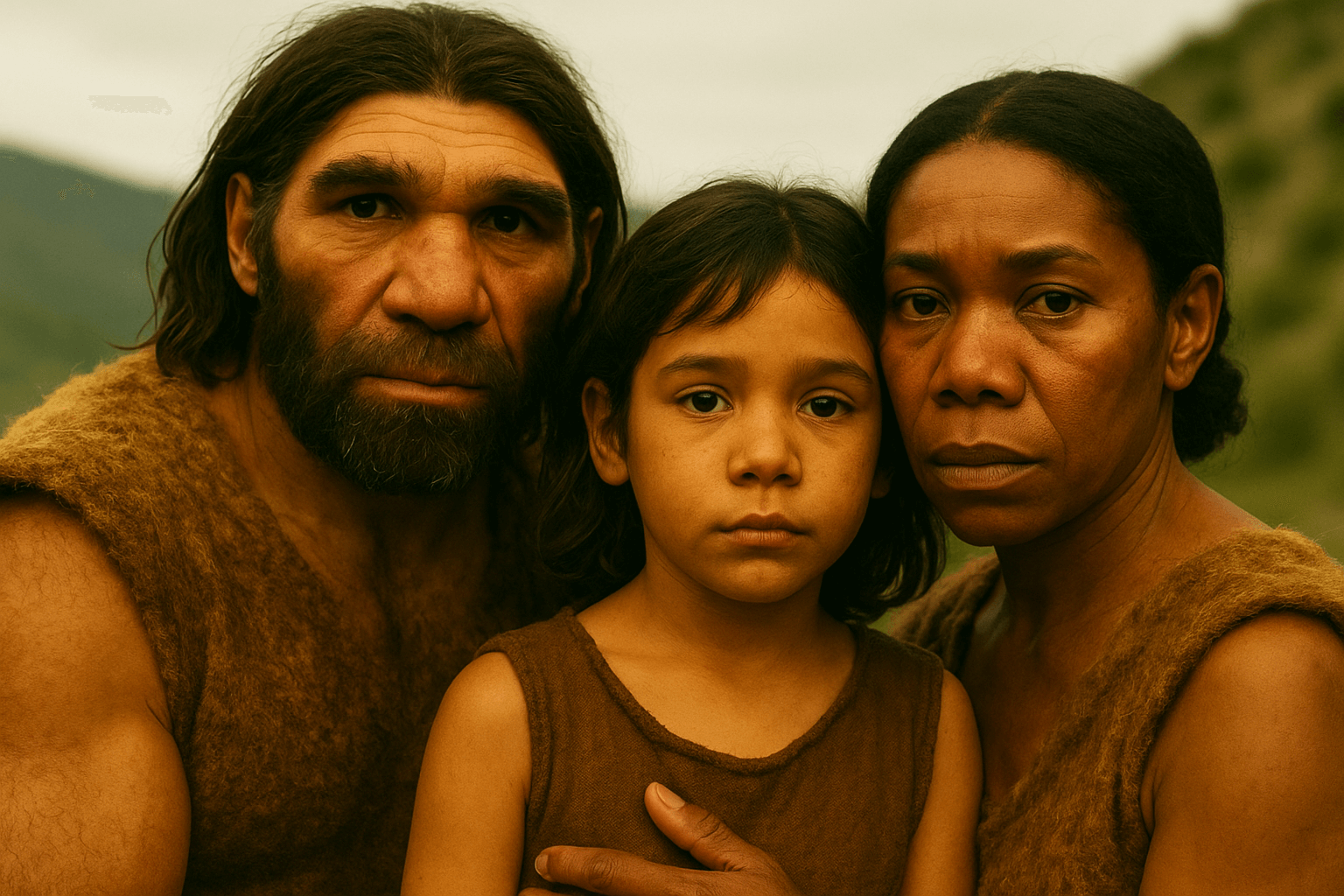
Peristeria reached the peak of its development during the early Mycenaean period (17th–16th century BCE) and continued to thrive until the 15th century BCE. During this time, the southern side of the hill was fortified with defensive walls, habitation increased, and a powerful local center emerged. This settlement was ruled by influential elites who controlled the region’s wealth and demonstrated openness to new cultural influences of the era.

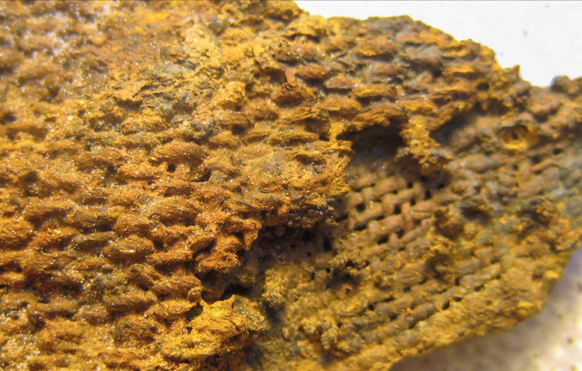
Their status and authority are reflected in the abundance of luxurious grave goods—crafted from gold and other precious or semi-precious materials—unearthed mainly in the site’s monumental tholos (beehive) tombs.

Layers of History Beneath the Hill

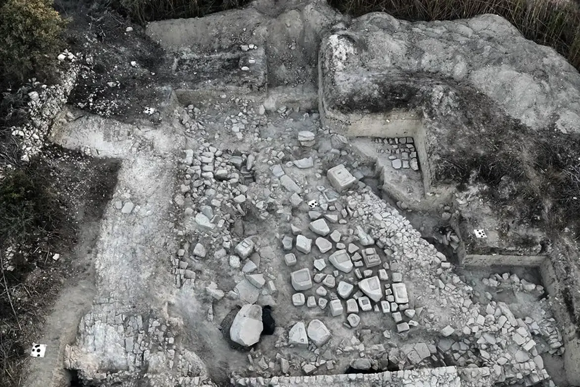
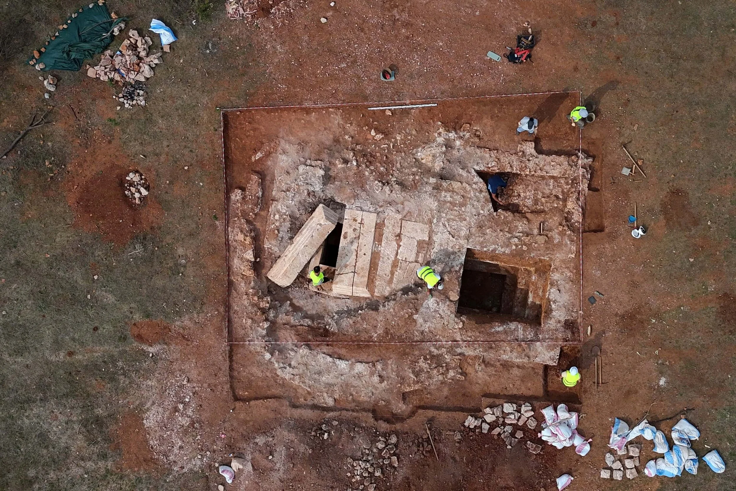
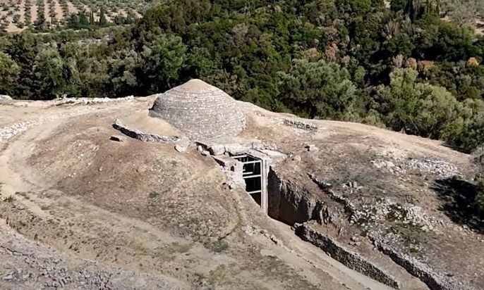
The earliest constructions on Peristeria’s hill date back to around 2200 BCE, particularly around the large, reconstructed tholos tomb. Among the most significant finds is a small, gold-rich tomb—named for the large number of gold objects discovered within. Nearby, in a multi-room building adjacent to the tomb, archaeologists uncovered a variety of household items, giving insight into daily life in the settlement.

A Glimpse into Life and Death in Mycenaean Times

To the west of the hill lies the third tholos tomb, the smallest of the three, with a diameter of 6.9 meters. Although only a two-meter-high section of its dome survives, the tomb dates to around 1200 BCE and contained some striking artifacts: a 13.5 cm tall golden cup, numerous gold leaves, and ornate gold jewelry. The discovery of military equipment in the tomb points to the warrior status of at least one of its occupants.

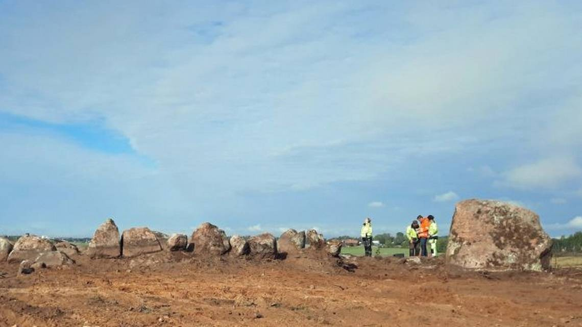
A fourth tholos tomb, located about 100 meters south of the main archaeological area, stood out for a different reason. Unlike the others, it contained no metal objects but had been used for over 15 burials. Archaeologists believe this was the cemetery for the general population of Peristeria. This finding is particularly significant, as it suggests that even ordinary people had access to this monumental burial style.

He Lived in the Parthenon with the Most Famous Courtesans—And the Athenians Loved Him

May 8, 2025

No one else ever dared to live inside the Parthenon. But Demetrius the Besieger did—and he did so in style, surrounded by the most famous courtesans of his time. And rather than condemning him, the people of Athens adored him.

A City Past Its Prime, Still Radiating Power

By 295 BCE, Athens was no longer the formidable city of Pericles. Yet it still held a magnetic charm for kings, generals, and philosophers alike. When Demetrius Poliorcetes entered the city, the Athenians didn’t treat him like a foreign conqueror—they welcomed him. They opened the gates of the Acropolis, and Demetrius moved right into the Parthenon itself.

This wasn’t just a military occupation—it was a personal statement. The temple once dedicated to Athena, home to her legendary statue, was transformed into Demetrius’s private residence. And he wasn’t alone. By his side was Lamia, the most celebrated courtesan of the Hellenistic era. She followed him like a queen in all but title.

A Scandalous Spectacle—or a New Ideal?

As shocking as it might sound today, the image of Demetrius turning the sacred heart of Athens into his personal palace didn’t provoke outrage. On the contrary—the city fell in love with him. They named him Savior, erected statues in his honor, and showered him with accolades surpassing those given to their most distinguished statesmen. Why? Perhaps because he brought with him wealth, charisma, and a sense of security during turbulent times.

No one before him had dared to inhabit the space built for the gods themselves. And yet Demetrius was embraced. For a moment in history, the Parthenon—Athens’s eternal symbol of divine power—became the residence of one of the most theatrical figures of the Hellenistic world. The sacred center of worship briefly became a center of earthly authority.

Lamia: More Than a Courtesan

Lamia, with her intelligence, courage, and independence, embodied a new era. In this shifting world, women of the court could be more than companions—they were icons of influence. Lamia didn’t hide in the shadows. She stood in plain view, proud of her place beside power. And the Athenians? They didn’t recoil at her presence—they admired her boldness.

Demetrius didn’t hold Athens forever, but his legacy lingered. No one else dared to do what he did—live inside the Parthenon. If that temple once belonged to the goddess Athena, for a brief moment, it belonged to the man who dared to sleep among its columns.

Artificial Intelligence Helps Solve One of Archaeology’s Greatest Mysteries

May 8, 2025

For over a century, the Nazca Lines of Peru have baffled archaeologists. These vast geoglyphs—created by the Nazca people between 200 BCE and 650 CE—stretch across the desert, depicting animals, plants, and tools in patterns so enormous they’re only fully visible from the air. The purpose behind these intricate designs has remained elusive—until now.

Thanks to a groundbreaking collaboration between archaeologists and artificial intelligence (AI), 303 new geoglyphs have been identified in just six months—doubling the number previously known. This remarkable achievement, reported by Science Focus, marks a major leap forward in unraveling one of archaeology’s longest-standing enigmas.

The Power of AI in Archaeological Research

Led by Professor Masato Sakai of Yamagata University’s Nazca Institute, researchers partnered with IBM scientists to train AI systems capable of scanning vast aerial image datasets. This allowed them to detect geoglyphs that had long gone unnoticed. As Sakai explains, “The ability to conduct such intensive research in such a short period of time was only possible with the help of AI.”

AI isn’t just helping archaeologists find more geoglyphs—it’s transforming the way ancient cultures are studied. By analyzing aerial photographs, AI can spot subtle patterns that the human eye might miss, offering a faster and more precise way to map and interpret ancient sites.

And this is only the beginning. The same technology is now being applied at archaeological sites around the world, from ancient burial mounds to long-lost shipwrecks.

A New Era in Understanding Ancient Civilizations

The Nazca Lines are now considered one of the most successful early case studies for AI in archaeology. Created by scraping away the top layer of desert soil to reveal lighter material beneath, these lines showcase the Nazca people’s advanced understanding of geometry and proportion.

German mathematician and astronomer Maria Reiche dedicated decades of her life to studying the lines, often emphasizing their “perfect” symmetry. Today, AI is helping researchers uncover even more of these designs, providing fresh insight into their possible meanings and uses.

Traditionally, archaeologists relied on ground surveys, photography, and manual mapping to study ancient sites. But as Dr. João Fonte of ERA Arqueologia notes, “Archaeology is truly at the forefront of innovation” when it comes to embracing digital tools.

In addition to AI, archaeologists are now using photogrammetry and remote sensing technologies to study expansive areas with unprecedented speed and accuracy.

Decoding the Purpose of the Nazca Lines

One of the most exciting outcomes of this AI-powered discovery is the growing understanding of why the Nazca Lines were created. Professor Sakai’s team believes many of the newly uncovered geoglyphs were part of ceremonial pathways—routes people walked to interact with the land and communicate with their gods. This supports the idea that the lines weren’t just artistic expressions but served spiritual and cultural purposes.

AI’s ability to identify and map these geoglyphs has opened new possibilities for exploring how the Nazca people connected with their environment, and how their knowledge of spatial planning and astronomy shaped their world.

Looking Ahead: The Future of AI in Archaeology

While AI has already revolutionized the study of the Nazca Lines, its potential in archaeology is far-reaching. Dr. Alexandra Karamitrou, an AI and archaeology specialist at the University of Southampton, is developing tools that could help identify a broader range of ancient sites.

Her research shows that AI can go beyond detecting visible features like geoglyphs—it can analyze complex relationships between these sites and environmental factors such as water sources or topography.

AI applications now extend well beyond South America. In 2023, researchers in the United Arab Emirates used AI to analyze satellite data from Saruq Al Hadid, a copper-smelting site dating back to 1270–800 BCE. The system provided insights into how artifacts were distributed across the site and helped prioritize excavation efforts.

This same technology could soon be used to study sunken shipwrecks, buried cities, or even how climate change has impacted ancient settlements.

Caution and Potential: The Limits of AI in Archaeology

Despite the promise of AI, it’s not without its challenges. Professor Sakai’s team still had to manually verify dozens of AI-generated suggestions for each newly discovered geoglyph. “AI isn’t perfect—especially in archaeology,” admits Dr. Karamitrou. “But in a few years, we could be developing highly accurate algorithms that save researchers time, energy, and money.”

As AI tools continue to evolve, they are expected to become even more precise—allowing archaeologists to explore larger regions with fewer resources. Automating the detection of ancient sites could dramatically increase the speed and scope of archaeological research, revealing hidden treasures and unlocking the secrets of long-lost civilizations.

The Ancient Greek Ports Swallowed by the Sea

May 8, 2025

In ancient times, the sea level was significantly lower. Today, some of the bustling ports of ancient Greece lie submerged beneath the waves. These once-thriving coastal hubs—centers of trade, life, and naval power—have been consumed by the sea, leaving behind only traces of their existence. Let’s explore the cities that have been literally swallowed by the water.

The image of a port as a place of life, commerce, connection, and shelter is deeply ingrained in Greece’s historical identity. Yet many ports that once hosted triremes, merchants, and generals now rest underwater, either submerged or vanished entirely—silent casualties of a changing seascape. These aren’t myths, but real places that highlight how dramatically landscapes can shift over the millennia.

During the Late Bronze Age, around 1200 BCE, sea levels were generally 1 to 2 meters lower than today. This means ancient ports were often located farther inland than one would expect now. Some now sit completely underwater, a testament to how time and nature have redrawn coastlines.

In the Argolid region, the ancient city of Asine once had a port that is now beneath the sea. Mycenaean structures in the area are still visible to divers—stone walls and roads lying quietly underwater. Here, the sea didn’t destroy history; it covered it, preserving fragments of the past beneath its surface.

On the island of Samos, the area around the Heraion (Sanctuary of Hera) was once protected by an artificial breakwater from the Archaic period, now submerged. Archaeological findings show the port was active in the 6th century BCE, while the current shoreline lies well inland compared to its ancient position.

In Piraeus, the ancient military harbors of Zea, Mounichia, and Kantharos have shifted significantly in relation to today’s coastline. Excavations and research have revealed highly advanced shipbuilding facilities for their time, complete with dry docks and warehouses—many now buried under modern constructions or lying underwater.

In Antikyra, Boeotia, the ancient harbor now lies several meters out to sea. Where ships once moored, only submerged lines of stone walls and foundations remain, visible only from the air or on especially clear days.

Off the western coast of Crete, in the Gulf of Kissamos, diving expeditions have uncovered submerged roads and building foundations, evidence that the shoreline of the Roman-era city was displaced due to seismic activity and gradual sea-level rise.

These changes aren’t due to rising seas alone. Earthquakes and land subsidence often played a role, triggering sudden and dramatic shifts in terrain. One striking example lies outside Greece but within the Hellenic world—Alexandria, Egypt. Large portions of this ancient Greek-founded city are now underwater, a powerful reminder of nature’s ability to reshape human settlements.

Back in the Argolid, the port of Epidaurus Limera also succumbed gradually to the rising sea. Once a bustling harbor, its facilities now form a popular diving site, where submerged ruins offer a glimpse into the past.

Ancient climate shifts, seismic events, and the complex geology of the Mediterranean have transformed Greece’s coastal landscapes. Where we now see sea, there may once have been a market, a temple, or a pier. Greece, renowned for its castles and sculptures on land, also hides a submerged world—an underwater history waiting to resurface, if only in the imagination of those who uncover its story.

Stalactites inside the Alistrati Cave, as part of a guided tour of the site
Photo: AMNA/Achilleas Chiras

Alistrati Cave: A Hidden Underground Wonder Guided by the Robot Persephone

May 8, 2025

Tucked away in the region of Serres, Northern Greece, the Alistrati Cave has welcomed more than a million visitors—both Greek and international—into its breathtaking depths. Often described as one of the planet’s underground marvels, it showcases extraordinary geological formations sculpted inch by inch over millions of years. These natural masterpieces leave guests awe-struck, especially when they discover that their journey through the cave begins not with a traditional guide, but with Persephone, the world’s only cave-based robot guide, fluent in 33 languages—including Ancient Greek and the regional dialect of Pontic Greek.

A Journey of Patience and Geological Artistry

The process of a single drop of water transforming into a stalactite or stalagmite is one of nature’s most poetic expressions of patience and persistence. Shaped by the slow passage of time and subtle geological forces, these formations often take centuries—even millennia—to develop. As Professor Nikos Kartalis, the cave’s scientific director and an economist at the University of Western Macedonia, puts it:

Nikos Kartalis, Scientific Director at the Alistrati Cave, pictured with Persephone, the robot tour guide
Photo: AMNA/Achilleas Chiras

“Every stalactite and stalagmite tells a story—one that reminds us of nature’s quiet yet relentless ability to create beauty.”

According to Kartalis, it takes about 40 days for a single drop of water to travel from the 40-meter-thick cave ceiling down to the ground. And to grow just one centimeter of a stalactite or stalagmite? That can take anywhere from 50 to 500 years.

Inside the Cave: A Living Museum Beneath the Earth

A Lego-built robot is programmed to give a tour on a tabletop map of the Alistrati Cave, as part of the site’s guided experience
Photo: AMNA/Achilleas Chiras

Located just six kilometers from the town of Alistrati, the cave stretches roughly three kilometers in length, with one kilometer accessible to visitors on guided tours lasting about an hour. The temperature inside remains a steady 18°C year-round—refreshingly cool in summer and comfortably warm in winter.

The cave is adorned with large stalactites and stalagmites in a range of colors, but what truly sets it apart are its eccentrics or helictites—rare formations that defy gravity with their twisting, seemingly impossible shapes.

“What makes the Alistrati Cave truly unique in Greece is its wide variety of eccentric formations,” notes Kartalis.

The cave is also home to microscopic life forms, including Alistratia Beroni, a one-of-a-kind isopod species measuring just 3 millimeters.

Persephone: The Robot Revolutionizing Cave Tours

Guiding visitors through the first 100 meters of the cave is Persephone, a robot developed by the Foundation for Research and Technology – Hellas (FORTH). Built entirely in Greece, both in hardware and software, Persephone can answer over 30 pre-set questions, providing a high-tech, multilingual introduction to the wonders of the cave. Its creation is part of the "i-cave" initiative—one of five steps in a broader digital transformation funded by the EU’s Interreg program.

But Persephone is just the beginning.

Stalactites inside the Alistrati Cave
Photo: AMNA/Achilleas Chiras

Visitors can now scan QR codes placed throughout the cave to access detailed geological information and even listen to the myth of Persephone’s abduction by Hades—in Ancient Greek, no less. The cave also offers 3D visualizations of its unique cave-dwelling species (including local bats and Alistrati Beroni), and a digital portrayal of its mythical inhabitant, the goddess Persephone.

Virtual Reality and the Future of the Alistrati Experience

The digital transformation doesn’t stop there. The Alistrati Cave is embracing Virtual Reality (VR), allowing visitors to explore areas of the cave that are inaccessible in person. There are also plans for educational robotics workshops where students can build and program miniature tour-guide robots to simulate Persephone’s path through a specially designed area.

Coming soon is a holographic installation of the goddess Demeter, Persephone’s mother, at the cave’s entrance. As visitors pass through the tunnel leading into the cave, the hologram will narrate the myth of Hades’ love for Persephone and her descent into the underworld—foreshadowing the ancient secrets hidden within the cave itself.

Nikos Kartalis, Scientific Director, presents an interactive virtual reality tour of the Alistrati Cave using a VR headset, as part of the site's guided experience in Alistrati
Photo: AMNA/Achilleas Chiras

A Model for Innovation and Sustainability

“With these developments, Alistrati Cave is not only a model of innovation and digital transformation for Greece’s caves—it’s setting an example for the world,” says Kartalis.
He emphasizes that technological advancements ensure both the site’s preservation and its ongoing appeal to new generations of explorers.

The Angitis Gorge Train: A Journey Through Prehistoric Art

Adjacent to the cave is the Angitis Gorge, once served by a tourist train that winds through the dramatic landscape. Though currently paused for infrastructure upgrades, it is set to resume in 2026. This unique experience begins and ends at the cave, taking passengers past prehistoric rock carvings that depict human activity and animal life from over 2,500 years ago. Along the way, guests may glimpse some of the gorge’s rare flora and fauna, including eagles, hawks, herons, and grey herons.

Historians can't agree on whether 93 or 94 human and animal penises adorn the Bayeux Tapestry
Source: Wikipedia

The Most “Blasphemous” Tapestry in the World? Historians Can’t Agree: 93 or 94 Penises?

May 8, 2025

The Bayeux Tapestry is one of the most celebrated works of medieval art, a nearly 70-meter-long embroidered masterpiece depicting the events leading up to the Norman conquest of England in 1066. Yet among its 70 intricate scenes and countless details of 11th-century life, a rather unexpected academic debate has emerged: does the tapestry feature 93 or 94 penises?

That’s right—penises. Some human, most animal. And historians are divided over the exact count.

First created just after the Battle of Hastings, the tapestry is believed to have been commissioned by Bishop Odo, the half-brother of William the Conqueror. It has been on display since 1983 at the Centre Guillaume le Conquérant in the French town of Bayeux and was added to UNESCO’s Memory of the World Register in 2007.

Despite its esteemed reputation, the tapestry’s surprising abundance of genitalia has sparked both curiosity and controversy.

93 or 94? The Penis Count Debate

In 2018, Oxford University professor George Garnett stated that the number totals 93 male genitals — 88 on horses and five on men
Source: Wikipedia

In 2018, Oxford University professor George Garnett made headlines by declaring that the tapestry depicts 93 penises—88 on horses and five on human figures. However, tapestry specialist Christopher Monk has argued that one more penis deserves recognition. He points to a soldier in the lower part of the tapestry whose unusually prominent anatomy is visible beneath his tunic.

“I have no doubt it’s a depiction of male genitalia,” Monk said in a recent episode of the HistoryExtra podcast.

Garnett, however, remains unconvinced. He believes the supposed penis is actually a sheath or weapon case, noting a golden orb at the tip that resembles the brass cap of a handle. “None of the other penises in the tapestry have a yellow spot on the end,” he explained.

This peculiar disagreement has reignited calls for a fresh analysis of the work. While a censored 18th-century copy exists in the Reading Museum in the UK—with most genitalia discreetly removed due to the era’s moral standards—it offers little help in settling the debate.

Why So Many?

So why are there so many penises in the first place? As with the exact number, the explanation isn’t entirely clear.

Medieval art is full of symbolism—from animals to flowers to colors—and the Bayeux Tapestry is no exception. Some historians believe the frequent depiction of genitalia may represent virility, power, or masculinity. A particularly notable example is the horse gifted to William the Conqueror, which is drawn with an especially large penis—a possible symbol of his legitimacy and strength as ruler.

However, tapestry expert Christopher Monk believes that one more penis deserves special attention
Source: Wikipedia

Others suggest these features may be playful or satirical, rooted in Aesopian fables or popular medieval folklore. “There are many interesting theories,” said historian David Musgrove on HistoryExtra, “but to be honest, we don't know for sure. What we do know is that these anatomical details are fascinating.”

Not Just a One-Off

Professor Garnett’s original findings—93 total penises, most on horses—were detailed in a 2018 paper that quickly went viral. “My academic colleagues had a good laugh,” Garnett admitted. “One of them even said, ‘You’re not just a historian—you’re a historian of masculinity!’”

He clarified that while the majority are simple anatomical details, three horses seem to have been drawn with particular attention to their genitalia. These horses are connected to key figures in the narrative, such as King Harold II of England and Duke William of Normandy, who are each shown riding stallions with distinctly exaggerated features.

“William’s horse has by far the largest penis,” Garnett observed. “And that is absolutely intentional.”

A Broader Artistic Tradition

The depiction of male genitalia in medieval art isn’t limited to the Bayeux Tapestry. As Garnett notes, similar motifs appear in sheela-na-gig carvings—grotesque female figures displayed on churches in the British Isles. The most famous example is found at Kilpeck Church in Herefordshire.

Interestingly, the Bayeux Tapestry includes no clearly rendered female genitalia—except in one ambiguous case, where a figure displays unusually dense pubic hair.

The depiction of human genitalia in medieval art is not unique to the Bayeux Tapestry
Source: Wikipedia

Whether it’s 93 or 94, the penis count in the Bayeux Tapestry may seem like a humorous academic footnote. But it opens up broader questions about how medieval artists used the body to convey power, identity, and satire—and how modern historians are still decoding those messages nearly a thousand years later.

Athens in spring
Photo: Shutterstock

The Rare Flower Found Only on the Acropolis of Athens

May 8, 2025

High above the city of Athens, nestled among the ancient stones of the Acropolis, a tiny botanical marvel quietly thrives. Known as Micromeria acropolitana, this exceptionally rare and endemic plant grows exclusively on the Sacred Rock of the Acropolis — and nowhere else in the world.

For more than a hundred years, this small perennial herb was thought to be extinct, both in Greece and worldwide. It was first discovered in 1906 by two French botanists and formally described in 1908 by Austrian botanist Eugen von Halácsy. After that, it seemingly vanished from existence.

Its remarkable rediscovery came a century later, in 2006, thanks to Greek biologist Grigoris Tsounis and his son, Lambros. Since 2004, Tsounis had been observing the area’s rich ecosystem while working on his book Around the Acropolis. During one of their walks near the site, the two stumbled upon the elusive plant. “As soon as I saw it from a distance, I said, ‘That’s a Micromeria’ — its small leaves gave it away. But which Micromeria exactly?” Tsounis recalls.

The mystery was solved in 2009 when Danish botanist Dr. Kit Tan, professor at the University of Copenhagen, confirmed that the plant was indeed the legendary Micromeria acropolitana.

This discovery confirmed that the species had not disappeared after all. Instead, it had survived in its original habitat — the Acropolis of Athens, home to the Parthenon, one of the most iconic monuments in the history of Western civilization.

The Micromeria acropolitana is a modest plant, growing between 5 and 30 centimeters tall. It blooms between May and June, producing tiny pink flowers. It typically grows in rock crevices and shallow soil, favoring spots with an eastern exposure.

Today, this plant is recognized as an important symbol of Greece’s natural heritage and biodiversity. It is protected by Greek law, as it faces multiple threats: human activity, tourism, uprooting, and even routine cleaning of the archaeological site can all endanger its fragile existence.

To safeguard the species, the exact location where it thrives remains a closely guarded secret. While the plant can be found in several areas of the Acropolis, one discreet spot allows this endangered species to grow undisturbed, away from the bustle of curious visitors.

In the shadow of ancient history, this delicate bloom stands as a living testament to resilience — a rare and beautiful reminder that nature endures even in the most historic of places.

Unusual Mummification Method Revealed in Austrian Clergyman from 1746

May 6, 2025

The remarkably preserved body of an Austrian clergyman who died in 1746 is shedding light on a little-known mummification technique that has intrigued modern scientists.

🕛 Reading time: 1 minute

Discovered in the crypt of St. Thomas Church in Blasenstein, Austria, the mummy offers rare insight into embalming practices of the time. Unlike many mummies found in the region, this one is exceptionally well-preserved, prompting researchers to investigate the method used.

A Secret Mummification Technique

According to a study published in Frontiers in Medicine, the body belongs to Franz von Roseneck, a local priest. What makes his mummification unique is the method used: scientists found that preservative materials were inserted into the abdominal and pelvic cavities via the rectum—a technique rarely documented.

By analyzing the remains, researchers discovered that the materials used included fir and spruce wood shavings, small branches, and fabrics like linen, hemp, and flax. These were likely chosen because they were readily available at the time and effectively absorbed bodily moisture, helping to preserve the corpse.

As reported by IFLScience, this approach contrasts with traditional embalming methods, which typically involve making incisions in the body to insert preservatives. Despite the unconventional technique, von Roseneck’s body—especially the chest and abdomen—showed minimal decomposition.

Identification and Insights from the Mummy

The mummy’s excellent condition also made identification possible. Scientific analysis confirmed the man died between 1734 and 1780, at around 35 to 45 years old—consistent with historical records of von Roseneck. Isotopic analysis revealed he had a high standard of living, eating grains native to Central Europe along with meat and fish, and showing minimal signs of physical labor—matching the expected lifestyle of a priest of his time.

Interestingly, traces of long-term tobacco use and signs of tuberculosis toward the end of his life were also found.

Researchers believe the body was prepared for long-term preservation, possibly in anticipation of being transported to his monastery. However, for reasons unknown, this transfer never occurred. It’s worth noting that the mummy was previously examined in 2000 using a portable X-ray device at the University of Vienna, but that early scan failed to detect the organic materials within, leading to the incorrect assumption that the priest had been poisoned.

Mummification as a Window into the Past

Scientists emphasize that unusual preservation techniques like this one provide valuable insight—not only into how people died, but also into how the living sought to honor and protect the dead. These discoveries help us better understand the rituals, resources, and beliefs of past societies.

Ancient Greece: Danish Historian Uncovers Scented Secrets of the Gods’ Statues

May 5, 2025

A new revelation by Danish historian Cecilie Brøns could reshape our understanding of how the gods were worshipped in ancient Greece and Rome. According to Brøns, statues of the gods were not only revered—they were perfumed and adorned with fragrant flower crowns and garlands.

Writing in the Oxford Journal of Archaeology, Brøns—curator at the Ny Carlsberg Glyptotek in Copenhagen—explains that evidence from ancient sources reveals people didn’t just perfume themselves, but also the statues of their deities housed in temples. These sacred scents were typically made with fat or oil as a base, creating a cream-like texture. Rose was a particularly popular fragrance across the Mediterranean.

According to dw.com, decorating the statues with floral wreaths and garlands created a multisensory, immersive experience for ancient worshippers. While the original scents have long faded, depictions and replicas made from metal, terracotta, and gold offer valuable clues about this ancient practice, known as "kosmesis"—a term referring to the ritual adornment of statues. This process also included dressing the figures in textiles and jewelry.

Brøns also notes that the statues were often treated with olive oil or beeswax to give them a luminous finish and to preserve their painted surfaces.

Importantly, the pure white marble statues we see in museums today are a far cry from how they originally appeared. Ancient sculptures were frequently made of wood, terracotta, or stone, and were almost always painted in vivid colors—challenging our modern perceptions of classical art.

Image Credit: Republic of Cyprus

Remnants of Colossal Statues Unearthed at Rediscovered Apollo Sanctuary

May 5, 2025

Archaeologists have rediscovered a long-lost sanctuary dedicated to Apollo in the Frangissa Valley near the ancient city-kingdom of Tamassos, Cyprus—an important site originally excavated in 1885 by German archaeologist Max Ohnefalsch-Richter but whose exact location had been forgotten.

Since 2021, teams from the Universities of Frankfurt and Kiel/Würzburg have been working to relocate the original excavation, which had been backfilled following its completion. Their efforts paid off in 2024, when they identified the sanctuary near the village of Pera Orinis. Excavations have since uncovered architectural foundations and a courtyard used for dedications.

According to a press release from the Republic of Cyprus, archaeologists have found more than 100 statue bases, including several colossal pedestals that once supported enormous votive limestone statues from the Archaic period (7th–6th centuries BC).

“It was an unexpected find—not only the bases for votive statues, but also numerous statue fragments in the 19th-century backfill,” noted the Department of Antiquities. “It seems these fragments were not recognised as significant during the original 1885 dig.”

Among the discoveries are two inscribed bases—one bearing Cypro-Syllabic script, and the other referencing the Ptolemies, the Hellenistic dynasty that ruled Egypt and Cyprus.

These findings suggest the sanctuary was a prominent religious hub well beyond the Archaic period. A large peristyle courtyard, likely used for ceremonial banquets, points to the site's continued use during the Hellenistic era.

Unusually for sanctuaries of this period, archaeologists also found votive objects not typically associated with Hellenistic worship, including marbled glass beads and Egyptian faience amulets.

Tourist Touches Parthenon Marble After Being Asked to Do So on TikTok – A New Low for Challenges

May 5, 2025

The craze around TikTok challenges has gotten out of hand.

It is illegal to touch the Parthenon, as it is an archaeological monument of utmost importance, strictly protected by both Greek and international law. Visitors are allowed to admire the Parthenon up close, but it is explicitly prohibited to touch it, climb on it, write on it, or take any pieces from it—even if someone asks them to do so for a TikTok challenge…

This ban is not just for reasons of respect, but also to protect the fragile materials (mainly marble) and prevent damage. Offenders could face fines or even criminal penalties, depending on the severity of the act.

The Incident

Despite this, a tourist in Greece was asked by someone if they could touch the Parthenon, and the tourist complied, even posting a video of the act on TikTok. This sparked outrage among those who saw the video.

Watch the video here: https://www.reddit.com/r/GreeceTravel/s/ElwmOE1jck

Here are some of the comments:

  • u/MrTheta: “Thanks. Now we’re all collectively dumber for having watched this.”

  • u/justforfun75: “What an idiot. Too bad what he touched was the new marble filling and not an original stone.”

  • u/Awkward-Papaya7698: “I was hoping the ‘old stones’ would slap him in the face instead of the other way around.”

  • u/therealnickb: “It’s clear that his style is ‘be so annoying that people watch out of curiosity.’ Just don’t watch him. It’s better. Even saying ‘don’t watch him’ just makes them watch more.”

  • u/Toutetrien777: “I was there a few weeks ago and had an amazing time. The museum was fantastic. What a beautiful country. It’s sad that some people don’t show respect.”

  • u/ortcutt: “Athens, please bring back the punishment for idiots like this.”

  • u/Karmeleon86: “I hate that stupid camera on his tooth.”

  • u/GandalfYodaSisko: “Has anyone told him that most of the stones are already very old?”

  • u/WorldBiker: “He’s the type of tourist we don’t want in Greece.”

  • u/Snoo_51149: “Totally an idiot.”

  • u/Spirited-Ad-9746: “‘I touched some very old stones.’ You know, all the stones are kind of very old…”

  • u/charizmattik: “I’m going there for the first time in 2 weeks, and I’ll make sure not to touch the ‘old stones.’”

  • u/PimsriReddit: “Oh my God, no! I hate tourists like this so much. They’re the type who think rules don’t apply because they’re on vacation. I live in a tourist area in Bangkok, and I constantly see people climbing into Buddha statues’ laps or trying to ‘ride’ mythical creatures in temples. Fines need to be stricter.”

  • u/The-Last_Man_On_Mars: “What an absolute jerk.”

  • u/vanoitran: “I lived near Yellowstone before moving to Greece. Every year we’d hear about one or two idiots who ignored the signs and either got killed by a buffalo they wanted to pet or boiled by a lake they thought was just a hot spring. People like this really make me wonder about human nature.”

The Caryatids of Amphipolis Revealed in Full (PHOTOS)

May 5, 2025

Incredible in beauty and detail, the 2.27-meter-tall statues of the Caryatids at Amphipolis have been fully uncovered.

With the removal of three layers of porous stone from the sealing wall, located in front of the second partition wall, the Caryatids were revealed in all their splendor. They wear clinging chitons and long, fringed garments with rich pleating. The statues are adorned with kothorni, decorated in shades of red and yellow, and their toes are depicted with exceptional detail.

The figures stand upon marble pedestals, each 1.33 meters long and 0.68 meters wide, with the exposed height currently around 0.30 meters. The appearance of the pedestals features crowns and orthostates, following the style of marble wall cladding used throughout all the chambers. The distance between the two pedestals is 1.68 meters, the same width as the doorway of the first partition wall featuring the Sphinxes. Notably, the surface of the eastern Caryatid’s pedestal shows traces of red color. During the removal of the sandy fill near the Caryatids, parts of their hands were also found.

Geotechnical Analysis and Excavation Progress

In the third chamber, geotechnical sampling was carried out using a manual drill at pre-selected locations, leading to the discovery of a marble doorway, with an opening of 0.96 meters, on the northern wall.

In the same area, measurements of the air content inside the chamber were taken, revealing that levels of oxygen and carbon monoxide are within normal ranges. The only anomaly is the relative humidity (87%), while the temperature remains steady between 21.5°C and 22.7°C.

These microclimatic conditions do not pose any issues for the workers inside the chamber.

Ongoing Technical Work

Access to the third chamber of the monument for support installation and the continuation of excavation work is being systematically prepared with parallel ongoing actions.

The interdisciplinary team has decided not to enter the third chamber through the hole at the upper western part of the third partition wall, but through the ancient entrance. Therefore, before any other work begins, the fill in the second chamber will be removed, the fallen part of the lintel will be cleared, and the doorway between the second and third chambers will be supported using wooden elements.

Additionally, the support structures in the second chamber will be reinforced at a lower level to bear the additional external earth pressures following the removal of the fill. A working floor will be prepared by removing earth from the second chamber to facilitate the entry of large metal support structures for the third chamber. Furthermore, extra stones will be removed from the sealing wall in front of the Caryatids to make way for the conveyor belt used to remove soil and a crane to transport stones from the third chamber.

In the first chamber, soil will be removed up to a depth of 1 meter (almost down to the floor), and the support structure will be extended due to changes in the internal fill level.

Future Work and Planning

Work to lower the fill around and directly above the monument will take place after the first phase of temporary support installation in the third chamber. The full removal of the fill will follow after this initial phase.

A study is underway to define the support and propping measures for the third chamber, determining the quantities and placement of the support elements as well as the phases of their installation, coordinated with the ongoing excavation process.

To address the rainwater runoff around the monument, a drainage pipe is planned to be placed along the large trench outside the enclosure.

A geotechnical survey is also being conducted in the area to assess the composition and geotechnical properties of the surrounding materials. This survey will include a sufficient number of boreholes and laboratory tests.

Mesolithic stone figurine discovered in a cave
Photo: Nishiaki et al.

Ancient Figurine Discovered in Cave Tells the Story of a Lost Civilization — and the Mystery of Its Missing Face

May 4, 2025

An 8,000-year-old figurine discovered in a cave is shedding light on a pivotal moment in human history. Found in present-day Azerbaijan, this small sandstone sculpture—remarkable for its lack of facial features—is believed to be the oldest known piece of art in the region.

A Glimpse into the Mesolithic-Neolithic Transition

The Damjil Cave.
Photo: Sciencedirect

In a recent study published in Archaeological Research in Asia, a team of archaeologists from Japan and Azerbaijan analyzed the figurine using advanced technology to uncover details that trace the cultural evolution from the Mesolithic to the Neolithic era.

"This artifact captures a transitional period," the researchers note. "Its stylistic features are visibly distinct from Neolithic human representations in the area, offering valuable insight into the symbolic expressions of a society shifting from Mesolithic to Neolithic life in the South Caucasus."

SEM analysis of samples from Damjili and Tell Kosak Shamali.
Photo: Sciencedirect

The figurine was discovered in Damjili Cave, a site first explored by scientists in 1953. Layers within the cave show continuous habitation from the Middle Paleolithic through to the Neolithic period, with evidence of long-term settlement during the latter.

Stone Mesolithic figurine from the Damjili Cave.
Photo: Sciencedirect

From Discarded Stone to Cultural Treasure

Initially, the figurine—later designated "Unit 5.2"—was nearly discarded as a nondescript stone. Found embedded in sediment along the Kura River, the object appeared to be nothing more than a smooth, oval-shaped piece of sandstone. Fortunately, one keen-eyed researcher noticed faint carvings on its surface—markings that revealed it to be a deliberate and intricate work of art.

A microscopic examination confirmed that the lines were intentional carvings—the only human modification to the stone.

"The overall design strongly suggests a stylized human figure," the authors wrote.

X-ray fluorescence of the figurine.
Photo: Sciencedirect

Dating and Analytical Techniques

Radiocarbon dating places the figurine between 6400 and 6100 BCE, solidly within the Mesolithic period. To better understand its significance, researchers employed CT scanning, X-ray fluorescence (XRF), and scanning electron microscopy (SEM). These methods helped differentiate the piece from similar artifacts of the Neolithic era and assess its cultural context.

A Figurine Without a Face

X-ray fluorescence of the figurine.
Photo: Sciencedirect

One side of the sculpture features more detailed carvings, likely identifying it as the front of the figure. Measuring approximately 5.08 cm long, 1.25 cm wide, and 0.8 cm thick, the figurine demonstrates an impressive level of craftsmanship using only stone tools.

Vertical lines etched into the top may represent hair, while a clearly marked horizontal line across the "head" might depict a headband—or perhaps the edge of a hat—particularly since the top of the head is left unadorned.

Notably, the figure lacks any facial features, and it’s impossible to determine whether it was meant to represent a male or female form.

Microscope images of the figurine from the Damjili Cave at a 500 μm scale.
Photo: Sciencedirect

The lower half is more sparsely decorated, but includes three horizontal lines interpreted as a belt, and vertical lines that may depict a skirt or apron. The team also detected reddish areas rich in iron, suggesting that red pigment might have originally been used as part of the figurine’s design.

Computed tomography images show the varying intensity of the carvings on the figurine.
Photo: Sciencedirect

Fine Craftsmanship with Subtle Symbolism

Microscopic imaging revealed that the engravings were carefully crafted, though the depth and intensity of the incisions vary across the surface. This suggests both a skilled hand and possible shifts in the carving technique. The deepest cuts are located on the front of the head—highlighting the importance placed on this area by the creator, even though no facial details were included.

Mesolithic stone figurines from the Kaniza rock shelter, Gobustan (adapted from Rustanov, 1986).
Photo: Sciencedirect

“The incisions appear to have been executed with deliberate care, reflecting the artisan’s high skill level,” the study states. “The varying carving patterns point to a complex symbolic intention.”

A Unique and Rare Find

Selected petroglyphs of anthropomorphic figures from Gobustan (adapted from Farajova, 2011).
Photo: Sciencedirect

In addition to the figurine, archaeologists discovered remains of stone hearths, animal bones, and flaked stone tools, though sculpted stone objects such as this are exceedingly rare.

Neolithic clay objects/figurines from the Middle Kura Valley.
Photo: Sciencedirect

“Unit 5.2 is a remarkable discovery,” the team concludes. Its stylistic elements suggest a local artistic tradition, with potential influences from Southwest Asia. What makes it truly exceptional, however, is its uniqueness in the prehistoric record of the southern Caucasus.

The World’s Oldest Bridge — An Architectural Gem from a Lost Civilization Still Standing in Greece

May 4, 2025

Nestled in the rolling hills of Argolis in Greece lies a remarkable relic of the ancient world: the Kazarma Bridge. Built more than 3,300 years ago, this Mycenaean marvel remains not just intact—but still in use.

A Hidden Masterpiece of the Mycenaean World

Tucked away in the undulating landscape of the Peloponnese, near the village of Arkadiko, the Kazarma Bridge—also known as the Arkadiko Bridge—is a subtle yet awe-inspiring testament to ancient engineering. Believed to be the oldest bridge in the world still in operation, it dates back to around 1300 BCE, during the Mycenaean era. This Bronze Age relic transports us to a time when the Achaeans, ancestors of the Greeks, were building mighty citadels and carving out trade routes across the Mediterranean.

Far from being a forgotten ruin, the Kazarma Bridge stands as enduring proof of the ingenuity and foresight of a long-lost civilization.

A Mycenaean Bridge Still in Use

Today, the Kazarma Bridge is one of the few surviving ancient structures that remains in practical use. Its architecture perfectly showcases the advanced construction techniques of the Mycenaeans. Built using Cyclopean masonry—a style named after the mythical Cyclopes, whom the Achaeans believed were master builders—it consists of enormous, unworked limestone boulders stacked with such precision that no mortar was needed. This seemingly simple yet incredibly effective technique has allowed the bridge to endure for millennia.

The bridge measures 22 meters in length, 5.6 meters in width, and 4 meters in height. Its pointed arch, just over one meter wide, was designed to allow rainwater and small streams to pass beneath. The road surface, about 2.5 meters wide, was broad enough for the passage of Mycenaean war chariots—the primary mode of transport for aristocrats of the time.

One Bridge Among Many

The Kazarma Bridge is not an isolated feat. It forms part of a well-planned network of Mycenaean roads in the Peloponnese. Archaeologists have identified at least four other similar bridges in the Arkadiko area.

Among them is the Petrogephyro Bridge, which is still used today by pedestrians and livestock. It features a slightly higher arch than Kazarma’s. Another bridge near the village of Lykotroupi stands out for its stone curbs—crafted to guide chariot wheels and prevent accidents, showing an impressive understanding of safety in transport design.

These architectural achievements highlight the precision and skill of Mycenaean builders. Long before the invention of concrete or modern engineering, the Mycenaeans had already mastered the fundamentals of durable infrastructure. Their network of bridges supported military movements, enabled trade, and connected distant city-states—forming the backbone of a sophisticated and far-reaching civilization.

Archaeological Mystery: A Civilization Left Its Writing Everywhere, But Scientists Can’t Find a Trace of Its DNA

May 4, 2025

Despite laying the foundations for many modern alphabets, the Phoenician civilization—famed for its seafaring prowess and cultural influence—appears to have left behind little to no genetic footprint. A new genetic study has puzzled scientists by revealing a striking disconnect between the widespread cultural legacy of the Phoenicians and their biological presence in the populations they once touched.

The Civilization That Changed the Mediterranean

The Phoenicians emerged around 3,000 years ago in the region of modern-day Lebanon. Descendants of the biblical Canaanites, they rapidly developed into a dominant maritime and commercial power. Trading in gold, silver, copper, and tin, they navigated vast Mediterranean trade routes and established hundreds of coastal colonies across Europe and Africa.

Until recently, scholars assumed that these settlers—known as the Punic peoples in later eras, such as the Carthaginians—would carry a clear genetic signature from their Levantine origins. It seemed logical that their descendants would bear DNA linking them back to the Eastern Mediterranean.

A Genetic Twist: Sicilian and Aegean Origins

But new genetic research has upended that belief. Population geneticist Harald Ringbauer and his team analyzed ancient DNA from the remains of 210 individuals unearthed at archaeological sites across the Middle East, North Africa, and Europe. The findings, recently published in Nature, were surprising.

"Most Punic individuals showed no Middle Eastern ancestry," the researchers wrote. "Instead, their genetic profile aligned more closely with that of ancient Sicilians and Aegean populations."

The genomes also revealed significant heterogeneity, suggesting that Punic populations were more of a cultural construct than a direct biological continuation of the original Phoenicians.

From Name to Identity

Interestingly, even the term “Phoenician” wasn’t their own—it comes from the Greek word phoinix, likely referring to the luxurious purple dye (Tyrian purple) they produced and traded extensively. The Phoenicians themselves referred to their identity as Kena’ani, or Canaanites, preserving a connection to their ancestral roots.

Carthage’s Expanding Role

The study also highlights the increasing genetic influence of North Africa on Punic populations, particularly through the rise of Carthage. Founded by Phoenician settlers, Carthage grew into one of the ancient world’s most powerful political and commercial hubs. Yet the DNA of its inhabitants doesn’t show a strong link to their Levantine founders.

Instead, it reveals extensive intermixing—evidence of centuries of cultural exchange and integration across the Mediterranean.

In Spain, a tomb at Villaricos revealed a family with genetic ties to Sicily and the Aegean, alongside grave goods like ostrich egg decorations and an ivory plaque—artifacts that reflect a vibrant and diverse cultural milieu.

While researchers noted Greek-style craftsmanship on the ivory plaque, such as the use of Ionian techniques, they caution that this doesn’t necessarily imply Hellenization. The Phoenicians were highly skilled artisans themselves, especially in ivory carving.

Cultural Survival Without Genetic Legacy

The team suggests that Phoenician cultural influence spread not through inheritance but through assimilation. Their language, technologies, and commercial practices were adopted by local populations—even as the Phoenicians’ genetic presence faded over time.

Adding to the mystery, the researchers note that prior to 600 BCE, the Phoenicians practiced cremation—a funerary custom that makes DNA recovery from earlier periods particularly challenging.

A Lasting Legacy Through Language

Although the name “Phoenician” stems from the Greek phoinix, possibly tied to their famous purple dye, the people themselves called their civilization Kena’ani. Their alphabet not only influenced the Greek writing system but also formed the basis of Latin, passing through the Etruscans before reaching the Romans.

Their DNA may have faded, but their influence—etched into scripts, trade routes, and craftsmanship—endures to this day.

Major Discovery: Researchers Uncover Remnants of a Lost Civilization in a Hidden Mexican Cave

May 4, 2025

A remarkable archaeological discovery has emerged from the depths of a cave in Mexico, where researchers have uncovered artifacts linked to a vanished civilization—shedding new light on ancient spiritual practices and forgotten peoples.

The breakthrough occurred during a mapping expedition in Tlayócoc Cave, nestled in the Sierra de Guerrero mountains. Spearheading the mission was professional cave explorer Yekaterina Katiya Pavlova, who journeyed to the remote area to expand the known map of the cavern system. Alongside her local guide, Adrián Beltrán Dimas, Pavlova pushed beyond the previously charted zones and ventured through a submerged entrance into an unexplored passage.

What they found exceeded all expectations.

A Hidden Chamber and a Sacred Offering

The passage led to a concealed chamber, untouched by human presence for centuries. There, affixed to stalagmites, were two intricately carved shell bracelets—likely left as ritual offerings. According to a statement from Mexico’s National Institute of Anthropology and History (INAH), these artifacts hint at ceremonial activities within the cave.

But the discovery didn’t stop there. The team also uncovered a third bracelet, a massive snail shell, and fragments of black stone discs resembling pyrite mirrors—all dating back more than 500 years.

When archaeologists descended to the site for further investigation, they documented a total of 14 objects: three complete shell bracelets, one bracelet fragment, the large snail shell, a charred piece of wood, and fragments of eight stone discs, two of which were fully intact.

Symbols of a Forgotten Belief System

The bracelets, believed to be made from marine snail shells, were engraved with striking anthropomorphic imagery and symbols. Among the motifs were S-shaped figures known as xonecuilli, zigzag lines, and circles that form stylized human profiles. These may have represented deities or mythological beings.

Experts estimate the artifacts date to the Postclassic period, between 950 and 1521 CE—a time when the region was inhabited by the now-extinct Tlacotepehua ethnic group.

“This discovery is highly significant,” said INAH archaeologist Miguel Perez. “By studying the contextual relationship between the objects, we can interpret symbolic meanings, cultural practices, craftsmanship, and even trade networks.”

Further analysis revealed that the stalagmites had been deliberately modified in pre-Hispanic times, shaped into more spherical forms to suit ritual needs.

A Portal to the Sacred

According to Cuauhtémoc Reyes Álvarez, another INAH archaeologist involved in the research, the engraved figures and symbols likely relate to pre-Hispanic cosmogony—particularly themes of creation and fertility. “The sealed nature of the chamber allows us to understand how ancient people may have viewed these caves—as gateways to the underworld or sacred spaces tied to the earth and divine realms,” he noted.

The black stone discs found at the site closely resemble others discovered in nearby archaeological zones such as El Infiernillo, as well as more distant cultures like the Huasteca.

Clues to a Vanished People

Historical records suggest that extreme cold in the Sierra de Guerrero—rising over 7,850 feet (2,400 meters) above sea level and cloaked in dense oak and pine forests—may have driven inhabitants to lower elevations. Very little is known about the Tlacotepehua people beyond a few scattered 16th-century references to their existence.

Now, thanks to this extraordinary cave find, researchers have a rare opportunity to piece together the beliefs, artistry, and lifeways of a lost civilization—one that once saw caves not merely as natural formations, but as sacred thresholds between worlds.

Archaeologists examine the unusual arrangement of stones that appeared to “point” to a Viking grave (Photo: Alf Ericsson, Arkeologerna)

Unusual Stones Lead Archaeologists to Viking-Era Tomb — Two Coffins, Mysterious Fabric, and Clues of a Pagan-Christian Transition

May 4, 2025

On the outskirts of a Swedish town, an unusual arrangement of stones stood out in an otherwise flat and unremarkable landscape. The stones had long gone unnoticed—until archaeologists gave them a closer look. Intrigued by their peculiar alignment, the team suspected something significant might lie beneath. So, they began to dig.

Their hunch proved correct.

Archaeologists in Linköping, southern Sweden, uncovered a Viking-era grave—hidden beneath this curious stone formation. The discovery came just in time, as the area had been marked for future development. Prompted by the city authorities, excavation began in October 2022, with a focus on the mysterious stones, according to a press release issued by Sweden’s Arkeologerna (National Historical Museums) on April 24, 2025.

A Grave Revealed by Stones

The stone pattern was unlike any the archaeologists had seen before. Drone imagery captured rows of upright stones forming a recessed central area—leading researchers to dig at the center. Sure enough, they uncovered a Viking burial site dating to the 9th century.

Although no human remains were found, the grave still held rich archaeological value. Two coffins, along with weapons, cloth fragments, and other artifacts, offered key insights into Viking funerary practices.

Fifteen rusted nails—once used to seal one of the coffins—were found, as well as a forged iron axe head with remnants of its wooden handle. Measuring approximately 20.3 cm (8 inches), the wedge-shaped axe likely served both as a tool and weapon.

A Strange Fabric and a Hidden Knife

Next to the axe, archaeologists discovered fragments of a woven textile made from an unidentified material. Possibly part of the deceased’s clothing, the yellowish fabric drew particular interest due to its unusual preservation.

Another item found was a knife, about 17.8 cm (7 inches) long, believed to have been buried inside a wooden container. Its presence adds to the interpretation of the grave as one belonging to a person of some status.

A Glimpse into a Religious Shift

What makes this burial especially fascinating is the combination of pagan and Christian elements. Based on the tomb’s age, structure, and contents, researchers believe it represents a period of religious transition—when Christian customs began to influence long-standing pagan burial traditions.

Beneath and around the Viking tomb, several older cremation burials were uncovered. These may have been part of earlier pagan rites. The later inhumation—complete with coffin and grave goods—might have been an intentional act to "purify" or repurpose the site as beliefs shifted toward Christianity.

The piece of fabric found in the Viking Age grave (Photo: Acta Konserveringscentrum AB via Helander (2025) and Arkeologerna).

An Unexpected and Valuable Find

Archaeologists describe the discovery as both surprising and invaluable for understanding how burial traditions evolved in medieval Scandinavia. The excavation at Linköping, a city in the Östergötland province known for its university and aerospace industry, wrapped up in October 2022. All finds have since been removed for preservation and further study.

This remarkable site not only provides a snapshot of Viking life and death but also captures a unique moment in history—when old gods gave way to new faiths.

The Seven Secrets of the Luxor Obelisk in Paris

May 4, 2025

On October 25, 1836, over 200,000 people gathered in Paris’s Place de la Concorde to witness a historic event: the placement of the Luxor Obelisk in its new home at the heart of the French capital.

This awe-inspiring monument of ancient Egyptian craftsmanship, carved from pink granite during the reign of Pharaoh Ramesses II in the 13th century BCE, originally stood at the entrance of the Temple of Amun in Luxor. It was gifted to France by Egypt’s viceroy, Muhammad Ali Pasha, as a symbol of diplomatic friendship and cooperation between the two nations.

For nearly two centuries, the Luxor Obelisk has stood proudly as one of Paris’s iconic landmarks. Egyptologists have long believed that they had deciphered all of the hieroglyphic inscriptions adorning its surface. But now, Dr. Jean-Guillaume Olette-Pelletier, a leading scholar from the University of Paris-Sorbonne, claims there is more than meets the eye.

A Discovery from the Top

During the COVID-19 lockdown, Dr. Olette-Pelletier became the first expert since 1836 to receive permission to ascend to the top of the obelisk. Over several days, he conducted detailed measurements and analyses of the monument’s artistic patterns. His findings suggest that hidden messages have gone unnoticed for nearly 190 years.

Remarkably, Dr. Olette-Pelletier is one of only six people in the world with the ability to read "crypto-hieroglyphs" — a special category of secret messages subtly embedded within standard hieroglyphic inscriptions.

According to an interview he gave to Sciences et Avenir, one of these hidden inscriptions forms the phrase “Pacify the Ka power of Amun,” a reference to the divine life force associated with Amun, the ancient Egyptian god of air.

Secrets Yet to Be Revealed

While the full details of all seven hidden messages remain under wraps, Dr. Olette-Pelletier has confirmed that they will be published in an upcoming issue of the ENIM (Egyptologie et Nouvelles Interprétations Modernes), a respected journal of Egyptology.

If his findings are confirmed, they could shed new light on the obelisk’s symbolic significance — not just as a monument, but as a carefully encoded spiritual artifact, offering insights into the sacred beliefs and political intentions of ancient Egypt.

Mystery Surrounds Giant “False” Pink Door in Ancient Tomb of Egyptian Prince

May 4, 2025

Archaeologists in Egypt have uncovered a 4,400-year-old tomb belonging to a prince — and at its heart lies a towering “false” pink granite door, believed to allow the spirit of the deceased to pass in and out of the tomb.

The tomb is attributed to Prince Userefre, son of Pharaoh Userkaf, who ruled Egypt from approximately 2465 to 2458 BCE during the Fifth Dynasty.

A Door for the Afterlife

This recently discovered false door, as revealed by the Egyptian Ministry of Tourism and Antiquities, bears inscriptions identifying the prince as a “crown prince,” as well as a “judge,” “minister,” “governor of two regions,” and a “chanting priest.” Despite his many titles, the prince and his tomb were previously unknown to scholars.

“Before this discovery, we didn’t even know he existed,” said Ronald Leprohon, professor emeritus of Egyptology at the University of Toronto, who was not involved in the excavation.

Standing at about 4.5 meters tall and 1.2 meters wide, the door is carved from pink granite — a material both rare and prestigious. In ancient Egypt, false doors were a common feature in tombs. According to the Metropolitan Museum of Art in New York, they were believed to function as spiritual gateways, allowing the soul of the deceased to travel between the world of the living and the afterlife.

Fit for Royalty

Experts say the size and material of the door reflect the prince’s elevated status. Pink and red granite had to be quarried and transported from Aswan — roughly 644 kilometers to the south — and were typically reserved for royalty and the elite.

Nearby, archaeologists also found an offering table made of red granite. Leprohon explained that in ancient Egyptian burial practices, food offerings were often placed on these tables so that the deceased could “magically” consume them. In reality, the food was usually eaten by the tomb priests or the deceased's family during rituals of remembrance.

A Tomb with Layers of History

Interestingly, the tomb appears to have been reused centuries later, during Egypt’s 26th Dynasty (around 688 to 525 BCE). At that time, a statue depicting King Djoser — along with his wife and children — was placed inside the tomb. Djoser, who ruled during the Third Dynasty (circa 2649–2575 BCE), is best known for building Egypt’s first pyramid: the famous Step Pyramid at Saqqara.

Analysis of the statue suggests it may have originally stood in or near that very pyramid complex. Why it was later moved to the tomb of Prince Userefre remains a mystery.

The Search Continues

So far, archaeologists have yet to locate the actual burial chamber of Prince Userefre. Excavations at the site are ongoing, with hopes of uncovering more about the life — and afterlife — of this long-lost royal.

The Earliest Known Mathematical Tablets of Mesopotamia and Elam

May 4, 2025

By Dimosthenis Vasiloudis


Early mathematical tablets (c. 1900–1700 BC) from Mesopotamia and Elam, with their geographical origin and diagrams of their content.

Mesopotamian mathematics refers to the mathematical practices of the ancient civilizations of Mesopotamia (modern-day Iraq and surrounding regions), including Sumer, Babylonia, and Assyria. It is one of the earliest highly-developed mathematical traditions in history, predating Greek mathematics by many centuries. The Mesopotamians developed a sexagesimal (base-60) place-value numeral system​ and recorded their calculations on clay tablets in cuneiform script. Hundreds of these tablets – especially from the Old Babylonian period (c. 1900–1600 BC) – have been unearthed, covering a wide range of topics from practical computations for trade and agriculture to advanced algebraic and geometric problems​. For instance, ancient scribes drew up tables of multiplication and reciprocals, as well as tables of squares, cubes, and even exponential growth, and they could solve quadratic and cubic equations and calculate compound interest​plus.maths.org. Such accomplishments underscore a dynamic mathematical culture that thrived in Mesopotamia for over three thousand years​.

This long-lived mathematical heritage was not confined to Mesopotamia proper. In the neighbouring land of Elam (modern southwestern Iran), particularly at the city of Susa, archaeologists have discovered early mathematical tablets with similar content, indicating that advanced mathematical thinking spread across the region. In this bilingual article, we will explore some of the earliest known mathematical tablets – including Plimpton 322, the YBC 7289, YBC 7290, and YBC 11120 tablets from the Yale Babylonian Collection, and a notable tablet from Susa. Through these examples, we will examine the mathematical content of each tablet, their historical context and location, and how they demonstrate both the practical and abstract/theoretical mathematical understanding of the Mesopotamians.

The Plimpton 322 Tablet

Plimpton 322 is one of the most famous Mesopotamian mathematical tablets. It is a clay tablet from the Old Babylonian period (circa 1800 BC), believed to have originated from the city of Larsa in southern Mesopotamia. Roughly 13 cm wide and 9 cm tall (with part of the tablet broken, it is now preserved at Columbia University in New York (George A. Plimpton acquired it around 1922 and later bequeathed it to. The cuneiform text on Plimpton 322 is laid out as a table with four columns and fifteen rows. Each row corresponds to a set of numbers that form a Pythagorean triple—that is, integers (a, b, c) satisfying the equation a² + b² = c². In other words, the Babylonians clearly knew the relationship equivalent to the Pythagorean theorem long before Pythagoras, and they could find multiple examples of such integer solutions. The triples recorded on Plimpton 322 are neither few nor simple; in fact, the numbers involved are quite large, and there are far too many combinations to have been obtained by brute force trial-and-error, which implies that Babylonian scribes had systematic methods for generating Pythagorean triples. Modern research suggests they may have used algebraic techniques involving reciprocal pairs of numbers to produce these triples​.

The exact purpose of Plimpton 322 is still debated. Some scholars argue it may have served as a teaching tool or reference for school instruction—for instance, a master scribe could use it to generate problems about right triangles for students, using each row’s numbers as a different example. Others have noted its similarity to administrative lists, but the prevailing view is that it was intended for mathematical work. In any case, Plimpton 322 demonstrates an exceptionally advanced and abstract understanding of mathematics. By around 1800 BC, Babylonian scholars were not only aware of the right-triangle relationship but had tabulated 15 distinct solutions for it—a clear indication of theoretical interest. Notably, this occurs at least a millennium before the time of Pythagoras, showing that the principle of the Pythagorean theorem was known and used in Mesopotamia long before classical Greek antiquity.

YBC 7289 Tablet (Square Root of 2)

Another impressive example of Babylonian mathematical prowess is found on the tablet YBC 7289, part of the Yale Babylonian Collection. This small, circular clay tablet from the Old Babylonian period (18th century BC) contains an extremely accurate approximation of the square root of 2​. The tablet’s round shape and modest size suggest it was likely a student exercise in a scribal school – indeed, round tablets were commonly used by apprentice scribes for practice. On YBC 7289, a square is drawn, and numbers are inscribed relating to the square’s side and its diagonal. Along one side of the square is written “30” (presumably in some unit of length), and 1;24,51,10 is written along the diagonal​. In Babylonian sexagesimal notation, 1;24,51,10 represents 1 + 24/60 + 51/60² + 10/60³, which in decimal equals approximately 1.41421296 – a remarkably close value for √2 (since √2 ≈ 1.41421356), correct to at least five decimal places​. Below the diagonal, the product 42;25,35 is also written, which is exactly 30 × 1;24,51,10 (~42.4263888 in decimal)​. In this way, the scribe verified that for a square of side 30, the diagonal is ~42.43 in the same units, confirming the relationship 30 × 1;24,51,10 = 42;25,35. Essentially, the value 1;24,51,10 serves as the “diagonal coefficient” for the square – effectively the value of √2 in sexagesimal form. The approximation is so good that the square of 1;24,51,10 yields 1,59,59,59,38,1,40 in sexagesimal notation (nearly 2 exactly)​.

Beyond its numerical content, YBC 7289 highlights how Mesopotamians combined practical geometry with abstract number theory. On a practical level, finding a square’s diagonal given its side is useful for surveying land or constructing right angles in architecture. However, its appearance on a student tablet shows it was also used as a teaching example – instructors likely employed it to teach the concept of the diagonal and its non-integer value. Notably, the same numerical value (1;24,51,10) appears in other Babylonian sources, such as in coefficient lists for geometric computations​. This suggests that the Babylonians had general tables of constants – in this case, they knew that for any square, the ratio of diagonal to side is ~1.4142. Thus, YBC 7289 is clear evidence of a sophisticated theoretical awareness: an understanding of an irrational number (√2 cannot be expressed as a finite fraction) and the ability to calculate it with high precision. As modern scholars have noted, achievements like this – along with the Pythagorean triples of Plimpton 322 – demonstrate the advanced level of Babylonian mathematical education by 1800 BC​.

YBC 7290 Tablet (Trapezoid Area)

The tablet YBC 7290 highlights the practical side of Mesopotamian mathematics, as it contains an exercise in computing the area of a trapezoid – a problem directly related to land surveying and field measurement in antiquity. This clay tablet, also from the Old Babylonian period (c. 1800–1600 BC) and now in Yale’s collection, has on its obverse a drawn trapezoid with cuneiform notations specifying the lengths of the bases and the non-parallel sides​. Specifically, one base is given as 2;20 (sexagesimal, i.e. 2 + 20/60 = 2.333... in some length unit), the other base as 2;00 (2 units), and both slanted side lengths are 2;20​. The resulting area written within the figure is 5;03 20 (5 + 3/60 + 20/3600 in sexagesimal) square units​. From these numbers, we deduce the scribe applied a formula equivalent to taking the average of the two side lengths and the average of the two bases, then multiplying those averages to find the area​. In modern terms, this approximates the trapezoid area formula $A = \frac{(B_1+B_2)}{2} \times h$, except here the “height” $h$ was effectively estimated as the average of the slanted sides (a practical approach when perpendicular height was not directly measured). In essence, Babylonian surveyors used a rule of thumb for quadrilaterals: the area is the product of the average length of the sides and the average length of the bases​. While this formula is not exact for every trapezoid unless it is isosceles, it provides a reasonable approximation in many cases and would have been sufficient for practical survey needs.

YBC 7290 reveals how ancient scribes computed land areas – a task of prime importance for taxation and agriculture. At the same time, it showcases an abstract generalization: the scribe did not treat each field uniquely but applied a general formula (an average) that could be used in multiple situations. This indicates a recognition of underlying patterns in geometry: essentially, an empirical mathematical formula had been formulated. The presence of a figure diagram (with no text) on the reverse side​ suggests that the student also practiced drawing the shape, not just the arithmetic – a detail that provides insight into the teaching method: combining geometric drawing with calculation. This tablet, roughly contemporary with the previous examples (~18th–17th century BC), underscores that Mesopotamian mathematics included geometric rules with practical applications. Such ancient surveying rules, like the trapezoid area method, are forerunners of later geometric formulas and demonstrate how Mesopotamian scholars were beginning to articulate general principles about space and measurement.

YBC 11120 Tablet (Circle and π)

The tablet YBC 11120 from the Yale collection takes us into the study of circular measurements – specifically, the area of a circle. This Old Babylonian tablet (c. 18th–17th century BC) shows how the ancients calculated the area of a circle given its circumference. On the tablet, a circle is drawn accompanied by numerical annotations: the circumference is given as 1;30 (in some unit of length), and the square of that circumference is noted as 2;15​. Using these, the scribes computed the area by applying the formula $A = (;05) \times (\text{circumference})^2$, where “;05” in sexagesimal is 5/60 = 1/12​. In other words, they assumed the area of a circle equals one-twelfth of the square of its circumference. Translating this to modern notation: $A = \frac{1}{12} C^2$. We know that actually $A = \pi r^2$ and $C = 2\pi r$, so $A = \frac{C^2}{4\pi}$. Comparing with the Babylonian formula $A = \frac{C^2}{12}$, we see this corresponds to taking $\pi = 3$ (since $4\pi$ in the denominator becomes 12 when $\pi=3$)​. Indeed, the Babylonians often assumed $\pi \approx 3$ in practical calculations – for example, they typically took the circumference as 3 times the diameter, using the convenient approximation of 3 in most cases. In YBC 11120, following this rule, with a circumference of 1;30 (which is 1.5 in decimal), they obtained an area of 0;11 15, which equals 0 + 11/60 + 15/3600 = 3/16 = 0.1875 in decimal​. This is precisely the result given by $1/12 \times (1.5)^2$, confirming the use of the 1/12 constant (i.e. $\pi=3$). Notably, the scribes themselves indicate on the tablet that the factor 1/12 (written as ;05) was a “standard constant” employed in Babylonian computation​.

Despite this simplified value of $\pi$, the important fact is that the Babylonians had a procedure for finding a circle’s area – they understood that the area is related to the square of the perimeter (or equivalently the square of the diameter). YBC 11120 shows that scribes could adapt their methods (used for squares and rectangles) to curved shapes by introducing a constant into the calculation. It also suggests that although they usually used 3 for $\pi$, they were aware this was an approximation. In another tablet – discussed next, from Susa – we find that in special cases they employed a more refined value, $\pi \approx 3.125$ (25/8), to achieve higher accuracy​. Taken together, these circle computations reveal a blend of practicality and theoretical curiosity among Mesopotamian scholars: practical, because using 3 for $\pi$ was convenient for everyday purposes, but also theoretical, because there is evidence that learned scribes experimented with improving that constant when greater precision was desired.

The Susa Tablet (π ≈ 3.125)

The Susa tablet discovered in 1936 near Susa (in ancient Elam, modern southwest Iran) shows that Mesopotamian mathematicians did not always settle for π = 3, but sometimes pursued greater accuracy for π​. This tablet – published by E. M. Bruins in 1950 and later fully in 1961 by Bruins & Rutten – dates to the Old Babylonian period (19th–17th century BC) and is interpreted to yield π approximately 3.125, or $25/8$​. Specifically, the tablet’s text describes a geometric relationship: it states that the ratio of the perimeter of a regular hexagon to the circumference of the circumscribed circle equals a certain number. That number is given as 0;57 36 in sexagesimal (57/60 + 36/60²)​ – which in decimal is 0.96. This value essentially represents the fraction of the circle’s circumference relative to the hexagon’s perimeter: for a regular hexagon inscribed in a circle, the perimeter of the hexagon is 6r (where r is the radius), while the circle’s circumference is $2\pi r$. The ratio of these is $\frac{6r}{2\pi r} = \frac{3}{\pi}$. The tablet thus effectively asserts $\frac{3}{\pi} = 0.96$, which leads to $\pi = \frac{3}{0.96} = 3.125$​. Indeed, $25/8 = 3.125$, a value that differs from the true π (~3.1416) by only about 0.5%​. This improved approximation of π (3 + 1/8) is remarkable: although slightly low, it is significantly more accurate than the simple 3 that was normally used.

The Susa mathematical tablet underlines that there was a drive for theoretical exploration and precision when the context allowed it. While in everyday transactions or routine calculations the Babylonians deliberately used rounded values (like 3 for π) for simplicity, here we see a learned scribe engaging in a more nuanced geometric analysis. By examining a hexagon and a circle, he was essentially undertaking an early method to refine π via geometric comparison. This approach is reminiscent of similar efforts much later – for example, Archimedes in Greece (circa 3rd century BC) famously used inscribed and circumscribed polygons to approximate π. It appears, then, that the germ of such ideas was present in the ancient Near East over a millennium earlier.

We cannot be certain how, or if, such knowledge was directly transmitted to other cultures. However, Susa, being part of the Elamite and Babylonian cultural sphere, was later incorporated into the Persian Empire, which in turn interfaced with the Greek world. It is thus possible that the accumulated mathematical experience of Mesopotamia – including advanced notions of π and other constants – reached the Greeks indirectly through Persian rule and translations. Regardless of the transmission path, the very existence of this “π tablet” from Susa is evidence that the quest for mathematical accuracy and theoretical understanding had begun well before the classical era, within the civilizations of the ancient Near East.

Practical and Theoretical Knowledge in Mesopotamian Mathematics

The above examples show that Mesopotamian mathematics embodied both practical problem-solving and abstract theoretical exploration. On the one hand, tablets like YBC 7290 (trapezoid area) address immediate practical needs: measuring land, calculating areas for agriculture or construction, and handling economic computations (such as distribution of goods or interest on loans) were part of daily life, and mathematical methods were developed to serve these ends. Indeed, many Babylonian tablets are not “theorems” but tables and word problems related to commercial arithmetic, accounting, surveying, and engineering. On the other hand, we see tablets like Plimpton 322 and YBC 7289 delving into purely numerical or geometric ideas (e.g. Pythagorean triples, √2) with no obvious everyday application. The ancient scribes appeared comfortable moving between the real and the abstract: they could solve a concrete problem (such as a field’s area) and also engage with mathematical relationships for their own sake, showing a notable scientific curiosity. In fact, many of their “theoretical” problems were presented in the guise of practical riddles or story problems – for example, what we recognize today as quadratic equations appear in texts as problems about dividing plots of land or building projects – a didactic technique that allowed scribes to study abstract mathematics under the cover of realistic scenarios​.

This blending of utility and theory is closely tied to the educational system of ancient Mesopotamia – the so-called “tablet house” (edubba) scribal schools. There, student scribes first learned basics: they memorized multiplication tables, reciprocal tables, and metrological (measurement) lists needed for bureaucracy and commerce. As they advanced, however, they tackled complex problems requiring ingenuity and generalization. For instance, from Old Babylonian tablets we know they developed general methods for solving equations (algebra) framed as narrative problems: e.g. “finding the sides of a rectangle given its area and sum of sides,” “distributing grain with certain ratios,” etc. In such problems, scribes used equivalent transformations and steps that are essentially forms of algebraic solutions. As the historian Jens Høyrup has noted, even a fundamental discovery like the rule of the right triangle (what we call the Pythagorean theorem) likely emerged from the practical environment of lay surveyors – perhaps a scribe trying to compute land boundaries discovered the relationship, sometime between 2300 and 1825 BC, and then the knowledge was generalized and entered the teaching texts​. Once a new mathematical principle was found, it became part of the tradition and curriculum. This explains how we find the Pythagorean rule applied in seven different tablets from cities like Eshnunna, Sippar, and Susa​ – evidence that it had been incorporated as a broadly known result. In summary, the earliest mathematical tablets reveal a culture in which practical know-how coexisted with profound theoretical thought. The Mesopotamian mathematicians laid down foundational principles of number and measurement, achieving a level of abstraction and generalization that would (directly or indirectly) influence later developments in mathematics.

Legacy and Influence on Later Civilizations

The mathematical knowledge of Mesopotamia and Elam did not vanish with the passing of those civilizations – it influenced neighboring cultures and eventually became part of the broader stream of mathematical development. Several aspects of Babylonian mathematics appear to have been known or adopted by later peoples. One clear example is the division of the circle into 360 degrees and the use of the base-60 subdivision of time (minutes and seconds), which was taken up by the Greeks and remains in use to this day – a direct inheritance from Babylonian practice. During the Achaemenid Persian Empire (6th–4th century BC), which included Mesopotamia, and especially after Alexander the Great’s conquests (4th century BC), Babylonian astronomical and mathematical knowledge became accessible to Greek scholars. Greek astronomers such as Hipparchus and later Ptolemy explicitly utilized Babylonian records and sexagesimal computational methods for their calculations of planetary motions and celestial phenomena. It is well documented that Hellenistic astronomy heavily relied on the data and mathematical tools developed by the Babylonians (for example, lunar eclipse cycles and planetary position tables)​.

In the realm of pure mathematics, the transmission of knowledge is less directly attested, but there are suggestive hints and parallels. The famous Pythagorean theorem, for instance, was formally proved in Greek mathematics (in Euclid’s Elements during the 4th century BC) and attributed to Pythagoras (6th century BC), yet Babylonian tablets like Plimpton 322 show that the relationship $a^2 + b^2 = c^2$ was known and used over a thousand years earlier​. It is quite possible that scholars such as Thales of Miletus or Pythagoras himself – who, according to tradition, traveled eastward – encountered advanced Babylonian mathematics during their visits to Babylon (or via Egypt, which was also influenced by the Near East). Ancient authors describe Babylon as a center of astronomy and learning – disciplines inherently tied to mathematics. The Greek historian Herodotus and later writers acknowledged that the Greeks borrowed certain mathematical ideas from older cultures like Egypt; by the same token, knowledge from Mesopotamia likely found its way into Greek thought through the interconnected networks of the ancient world.

One concrete pathway of influence was astronomy: Babylonian astral science, with its sophisticated mathematical models, deeply informed Greek astronomy in the Hellenistic period. Concepts such as the zodiac, accurate eclipse prediction, and mathematical tables of planetary positions in Greece were built upon centuries of Babylonian observations and calculations. Moreover, some technical terminology and methods (for example, the use of reciprocal tables or certain algebraic solution techniques) may have traveled via scholars in the Seleucid era or via translations in major centers (like the Library of Alexandria). While Greek mathematicians developed a different style – more geometric and axiomatic – the foundational ideas, such as place-value notation, general algebraic problem-solving, and certain numeric constants, were part of the cumulative knowledge of the Near East that preceded them​.

In conclusion, Mesopotamian and Elamite mathematics provided an early blueprint for advanced mathematical thinking. This legacy was transmitted through time by both direct contact and the enduring utility of their innovations (for example, the sexagesimal system for measuring time and angles that we still use today). The ancient Greeks, and subsequently other civilizations, built upon this foundation, whether explicitly or implicitly. The clay tablets of Mesopotamia stand not only as archaeological artifacts but also as testimony to a seminal chapter in the global history of mathematics – one that set the stage for later mathematical achievements in the classical world and beyond.

References

  • Eleanor Robson, Mathematics in Ancient Iraq: A Social History. Princeton University Press, 2008.

  • Otto Neugebauer & Abraham Sachs, Mathematical Cuneiform Texts. American Oriental Society, New Haven, 1945.

  • E. M. Bruins & M. Rutten, Textes mathématiques de Suse. Mémoires de la Mission Archéologique en Iran, vol. 34, Paris: P. Geuthner, 1961.

  • Eleanor Robson, Neither Sherlock Holmes nor Babylon: A Reassessment of Plimpton 322. Historia Mathematica 28 (2001): 167–206.

  • Jöran Friberg, Unexpected Links Between Egyptian and Babylonian Mathematics. World Scientific, 2005.

  • Jens Høyrup, Lengths, Widths, Surfaces: A Portrait of Old Babylonian Algebra and Its Kin. Springer, 2002.

  • Victor J. Katz (ed.), The Mathematics of Egypt, Mesopotamia, China, India, and Islam: A Sourcebook. Princeton University Press, 2007.

  • Frank J. Swetz, Mathematical Treasure: Old Babylonian Area Calculation. Convergence (MAA), March 2014.

  • David Gilman Romano, Athletics and Mathematics in Archaic Corinth: The Origins of the Greek Stadion. American Philosophical Society, 1993.

  • Petr Beckmann, A History of Pi. St. Martin’s Press, 1971.

  • “Before Pythagoras: The Culture of Old Babylonian Mathematics.” Exhibition Catalog, Institute for the Study of the Ancient World (NYU) & Yale Babylonian Collection, 2010.

  • Marcus du Sautoy (presenter), “The Language of the Universe.” The Story of Maths (Episode 1). BBC Four, 2008.

In Mesopotamia Tags The Archaeologist Editorial Group, Dimosthenis Vasiloudis
← Newer Posts Older Posts →
Featured
imageye___-_imgi_90_abrahamic-family-hosue (1).jpg
Sep 30, 2025
A Mosque, Church & Synagogue Together: A New Symbol of Religious Coexistence in the UAE
Sep 30, 2025
Read More →
Sep 30, 2025
549705914_18367966132146898_7383368493639402982_n (1).jpg
Sep 29, 2025
A New Gateway to Ancient Wonders: The GEM Walkway to the Pyramids Officially Completed
Sep 29, 2025
Read More →
Sep 29, 2025
Image 15 2025 (1).png
Sep 15, 2025
Vestments Through the Ages: Tradition, Craft, and Cultural Continuity
Sep 15, 2025
Read More →
Sep 15, 2025
imgi_70_Wealthy-ancient-Romans-tomb-discovered-in-Albania-h4hpncqb.jpg
Sep 9, 2025
Albania’s First Monumental Roman Tomb: A 3rd–4th-Century Chamber with a Rare Bilingual Inscription
Sep 9, 2025
Read More →
Sep 9, 2025
An Intact Roman Altar from the Theater of Savatra: Epigraphic and Iconographic Insights
Sep 8, 2025
An Intact Roman Altar from the Theater of Savatra: Epigraphic and Iconographic Insights
Sep 8, 2025
Read More →
Sep 8, 2025
ChatGPT Image 3 Σεπ 2025, 10_03_02 μ.μ..png
Sep 3, 2025
The Oldest Known Human Fossil that Blends Homo Sapiens and Neanderthal Species in Both Body and Brain
Sep 3, 2025
Read More →
Sep 3, 2025
read more

Powered by The archaeologist