Introduction
Prehistoric hunters developed a wide range of strategies for locating, pursuing, and capturing animals. Some methods involved individual stalking, while others depended on coordinated groups, landscape knowledge, traps, and carefully planned routes of animal movement.
One particularly important form of communal hunting involved game drives: arrangements that guided animals toward a restricted area, a trap, or a location where hunters could intercept them. Depending on the environment and period, these systems could use stone walls, earthen barriers, natural landforms, or temporary structures.
Many hunting features are difficult to recognize from the ground. Erosion, vegetation, later agriculture, and the accumulation of sediment can obscure their original form. LiDAR—Light Detection and Ranging—has become an important tool for identifying subtle landscape features that may represent ancient hunting systems.
Nevertheless, LiDAR reveals shapes and surface differences, not their meaning automatically. Archaeological fieldwork is necessary to determine whether a detected feature was a game drive and to establish its date, purpose, and relationship to prehistoric hunting practices.
What Is a Game Drive?
A game drive is a hunting arrangement designed to influence the movement of animals.
Hunters may use barriers or natural terrain to guide animals along a predictable route. The route might lead toward a narrow passage, an enclosed area, a cliff edge, or a location where hunters could use projectiles or other weapons.
The precise design depends on the animal species, the landscape, and the hunting community's knowledge of animal behavior.
Some systems could be used by relatively small groups, while others required coordination among many participants. A large hunting feature does not necessarily indicate that hundreds of people used it at one time; it may have been constructed, modified, or reused over many generations.
The Landscape as a Hunting Tool
Prehistoric hunters relied on detailed knowledge of their surroundings.
Ridges, valleys, water sources, migration corridors, and areas of seasonal vegetation could influence where animals traveled. By understanding these patterns, hunters could choose locations where animal movement was more predictable.
Game drives transformed this environmental knowledge into physical infrastructure.
A barrier placed along a slope might redirect animals toward a passage. A series of walls could narrow their movement gradually. Natural cliffs or ravines could provide part of the system, reducing the amount of construction required.
These arrangements demonstrate that hunting was not always an improvised activity. In some societies, it involved planning, shared labor, and an understanding of landscape geometry.
What Is LiDAR?
LiDAR is a remote-sensing technology that measures distances using laser pulses.
Airborne systems emit pulses toward the ground and record the reflected signals. When combined with accurate positioning data, the measurements can produce detailed three-dimensional models of the landscape.
In forested areas, some laser pulses pass through gaps in the vegetation and reach the ground. By processing the resulting data, researchers can generate a model of the terrain beneath much of the canopy.
This can reveal low walls, shallow depressions, abandoned roads, terraces, embankments, and other features that may be nearly invisible in ordinary aerial photographs.
LiDAR does not literally see through every tree, and its effectiveness depends on vegetation density, survey conditions, data quality, and processing methods.
Detecting Buried and Overgrown Features
The phrase "buried game drives" can refer to hunting features that have become obscured by soil, vegetation, or later land use.
LiDAR is particularly effective at revealing subtle surface topography, including features hidden beneath vegetation. It is less able to identify structures that are completely buried beneath a substantial layer of soil without affecting the modern surface.
A depression, ridge, or linear feature detected by LiDAR may represent a prehistoric hunting structure, but it could also be a modern field boundary, drainage channel, road, forestry feature, or natural landform.
Researchers therefore use LiDAR as a discovery tool rather than a final identification method.
Recognizing Hunting Systems in Digital Terrain Models
Archaeologists may inspect several types of visualizations derived from LiDAR data.
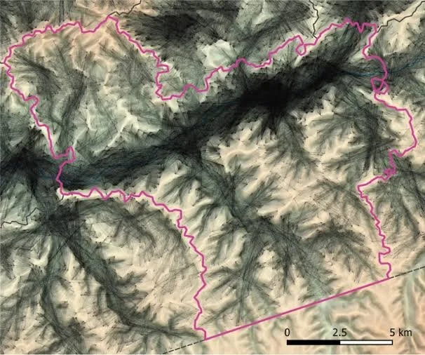
Hillshade images simulate the appearance of terrain under different lighting directions. Slope maps emphasize changes in steepness, while contour models and local-relief visualizations can reveal small variations in elevation.
Changing the simulated light direction is important because a feature visible under one angle may disappear under another.
Researchers can also compare candidate features with known examples of game drives and other archaeological structures.
The goal is to identify patterns that are difficult to explain through natural processes or modern land use.
From Lines to Hunting Architecture
A long, narrow wall might initially appear to be a simple boundary. Its interpretation changes if several lines converge toward a restricted passage or form a funnel-like arrangement.
Repeated structures can provide additional clues.
For example, two lines of barriers that narrow toward a central location may suggest that movement was deliberately controlled. A nearby enclosure or concentration of hunting-related artifacts could strengthen the interpretation.
However, shape alone is insufficient. Ancient agricultural boundaries, livestock enclosures, defensive works, and transportation features can produce similar patterns.
The surrounding landscape and archaeological context are therefore essential.
Field Verification
After LiDAR identifies a candidate feature, researchers generally need to inspect it on the ground.
Fieldwork may document wall construction, stone size, soil accumulation, erosion, vegetation, and relationships with nearby features.
Surveyors may record the feature with GPS or other mapping systems. Limited excavation may be considered when permitted and necessary.
Archaeologists also investigate whether the structure crosses natural obstacles or follows a route that would make sense for directing animal movement.
A convincing interpretation should explain the entire arrangement rather than only one isolated segment.
Dating Game Drives
Dating can be difficult because hunting structures may contain little organic material.
Possible methods include radiocarbon dating of suitable organic remains, optically stimulated luminescence dating of sediments in appropriate contexts, and analysis of artifacts associated with construction or use.
Each method answers a different question.
Radiocarbon dating may establish when an organism died, but the sample must be securely associated with the feature. Luminescence dating may help determine when mineral grains were last exposed to light or heated, depending on the method and context.
Researchers must also distinguish the date of construction from the date of later use or repair. A barrier may have been modified repeatedly over a long period.
Mass Hunting and Social Organization
Large hunting systems can reveal aspects of social organization.
Constructing a substantial barrier may require coordinated labor, planning, and knowledge of animal behavior. A successful drive might also require people to take different positions and act at the appropriate moment.
However, the scale of a structure does not directly reveal the political organization of the people who built it.
Cooperation could occur among extended families, neighboring communities, seasonal gatherings, or more centralized groups. Evidence about settlements, diet, tool production, and social relationships is needed to investigate these possibilities.
The Archaeology of Prey Remains
Animal bones can help establish whether a site was associated with hunting.
Researchers identify species, estimate the ages of animals, examine cut marks, and investigate patterns of breakage or burning.
A large concentration of bones from a particular species may indicate a hunting or processing event, but alternative explanations must be considered. Natural deaths, carnivore activity, and later disturbance can also create bone accumulations.
The strongest evidence comes from the relationship between animal remains, hunting structures, artifacts, and the chronology of the site.
Environmental Change and the Preservation of Hunting Features
Game drives may survive in some landscapes while disappearing in others.
Stone walls can remain visible for centuries, while earthen structures may erode more rapidly. Forest growth can obscure features, and modern agriculture can flatten or remove them.
Changes in animal populations also affect how hunting landscapes are interpreted. A structure built to direct a species that no longer inhabits the region may seem puzzling unless past environmental conditions are considered.
Pollen, animal remains, sediment records, and climate reconstructions can help establish the ecological context.
Limitations of LiDAR
LiDAR surveys produce enormous quantities of data, and researchers must decide which features deserve closer investigation.
Automated algorithms can help identify lines, depressions, and geometric patterns, but they may also produce false positives. Natural drainage systems, tree falls, and modern infrastructure can resemble archaeological remains.
Survey coverage may also be incomplete. Dense vegetation, steep terrain, and data-processing choices can influence which features become visible.
For these reasons, LiDAR findings should be reported with appropriate levels of confidence and supported by ground-based evidence whenever possible.
Conclusion
Buried and overgrown game drives offer an important opportunity to study prehistoric hunting as a planned and sometimes communal activity. LiDAR can reveal subtle terrain features that are difficult to detect through ordinary survey, allowing researchers to identify possible barriers, funnels, and hunting corridors across large landscapes.
Yet a digital model cannot independently establish the age or function of a structure. Field verification, dating, animal-bone analysis, environmental reconstruction, and comparison with alternative explanations remain essential.
When used carefully, LiDAR helps archaeologists move beyond isolated artifacts and investigate the broader landscapes in which prehistoric people hunted, cooperated, and adapted their strategies to the behavior of animals and the shape of the land.