Immerse yourself in the mesmerizing world of ancient languages with our captivating video. Experience the enchanting sounds of bygone civilizations as realistic characters bring them to life. Journey through time as you listen to the melodic tones of forgotten tongues, each carefully researched and expertly voiced. From the mysterious cadence of Egyptian hieroglyphics to the lyrical beauty of Latin, let the echoes of the past transport you to a realm of linguistic wonder. Discover the linguistic heritage of our ancestors and witness the power of language in preserving the legacy of ancient civilizations. Prepare to be captivated as history's forgotten voices resound once more.
What Vikings really looked like
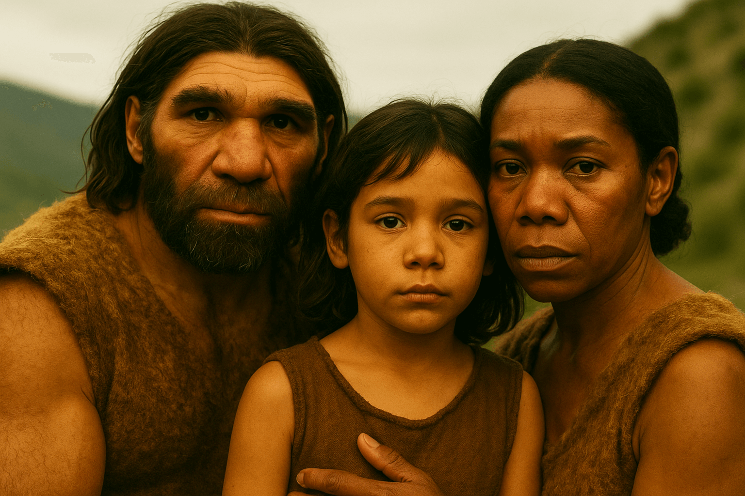
Were Vikings really dirty savages who wore horned helmets, or did they look like we do today? There’s no shortage of myths about the appearance of our notorious Viking ancestors, so to find out more about these myths watch this video and get a little more inside to what scientists have found out
Why the Oldest Stories of the Great Pyramid are Wrong
Four authors from Antiquity have had their detailed descriptions of the Great Pyramid survive to the present day. But Herodotus, Diodorus Siculus, Strabo, and Pliny the Elder all fail to record any mention of the Great Pyramid's upper chamber system.
This video examines why those four authors likely missed the upper chamber system based upon a pattern of deception that spans thousands of years. We also examine how the Great Pyramid would be experienced by visitors through history, and why their graffiti is often lost to the ravages of time.
What They Discovered Frozen In Ice Shocked The Whole World
In the following video we will be talking about a shocking discovery made in ice. Watch the video to find out more!
The Mysterious Ancient Weapon You're Not Allowed to See: Japan's Kusanagi no Tsurugi
In the heart of Japanese legend lies the powerful Kusanagi no Tsurugi, a sword enveloped in myth and shrouded in mystery. As one of the three treasured imperial regalia of Japan, the Kusanagi no Tsurugi symbolizes the legitimacy of the Japanese Imperial line and plays a significant role in Japanese mythology.
Despite being a symbol of courage and valor, this enigmatic weapon has been hidden from the world since the 12th Century, giving rise to rumors that it may have been lost. Its divine nature and adherence to ancient Shinto traditions dictate that it remains concealed, revealed only for the most sacred of ceremonies.
Once called the "Heavenly Sword of Gathering Clouds," the sword later earned the name Kusanagi no Tsurugi, or "Grass-Cutting Sword." Legends surrounding the sword have been passed down through generations, securing its place in Japanese folklore.
As World War II neared its end in 1945, the Japanese imperial family, fearing the sword's capture by Allied forces, concealed it in a secret location. While many have speculated on the sword's whereabouts, no location has ever been confirmed.
Some believe that the ancient Atsuta Shrine in Nagoya has housed the Kusanagi no Tsurugi for centuries. Historical records suggest that the shrine, perhaps due to the sword's presence, became a focal point during the 14th Century power struggles in Japan. As factions from northern and southern Japan battled for supremacy, both proclaimed Emperors sought to possess the legendary sword.
One of the few individuals who ever claimed to see it was the Shinto Priest Matsuoka Masanao, who is believed to have lived in the 17th Century.
His translated account describes the sword as follows: “a stone box was inside a wooden box of length 150 cm, with red clay stuffed into the gap between them. Inside the stone box was a hollowed log of a camphor tree, acting as another box, with an interior lined with gold. Above that was placed a sword.”
Of the relic itself, Masanao said “The sword was about 82 cm long. Its blade resembled a calamus leaf. The middle of the sword had a thickness from the grip about 18 cm with an appearance like a fish spine. The sword was fashioned in a white metallic color, and well maintained.”
For revealing such sensitive information and violating Shinto tradition, Matsuoka Masanao faced banishment from the Empire. History tells us that a handful of other priests who claimed to have glimpsed the sword met their end through mysterious diseases, further contributing to the sword's enigmatic legacy.
But where did the sword come from and where is it now?
Why The Crusades Were Awesome, Actually
The popular understanding of The Crusades in the West is that they involved barbaric, violent Christians invading the peaceful and enlightened Islamic world. Films like Kingdom of Heaven and Mankind: The Story of Us reinforce this narrative. But the truth is the reality of the Crusades is much, much different. In fact, it's the polar opposite. In this video on Pax Tube, we will explain why The Crusades were not only morally justified, but were also a historic achievement. Buckle up for a crash course in over 1,000 years of European and Middle Eastern history!
The Real Story Of The Dodo Bird's (Current) Extinction
What’s the real story of the dodo? How did such a unique bird even evolve in the first place? And are we really responsible for its extinction? Watch the video below to find out!
5 Ancient Artifacts That Mysteriously Disappeared
In the late 15th century, Myanmar was an enlightened nation. Under the reign of King Dhammazedi, a former Buddhist monk, the country reached a pinnacle in antiquity during the Golden Age – complete with treasures to match. Cast in the 15th Century, the Great Dhammazedi Bell was, according to popular legend, placed alongside the gleaming gold Shwedagon Pagoda, the most sacred Buddhist site in Myanmar.
Said to be the largest bell ever made, the Great Bell is said to measure roughly 20 feet by 13 feet and was cast from 294 tons of metal, including silver, gold, copper and tin. It was engraved with a script described by a visiting foreigner as indecipherable language covering the entire surface.
In the 16th Century, European explorers began to make contacts in Lower Burma and the Portuguese warlord and mercenary Filipe de Brito e Nicole was one of them. This adventurer worked for the rival Arakanese culture and led a force that sacked the cities of Syriam and Pegu, the capital of Lower Myanmar. He was appointed by the King of Arakan as the governor of Syria and by 1600, had extended his power across Myanmar.
After declaring independence from the Arakan King, in 1608 De Brito and his men removed the Dhammazedi Bell from the Shwedagon Pagoda, intending to melt it down to make a massive cannon. After rolling it down a hill, they placed it on a waiting raft on Pazundaung Creek. Unfortunately, the bell was far heavier than De Brito could have imagined and whilst travelling along the river, the bell disappeared under the waters and has never been seen since.
Many rescue attempts to retrieve the bell have been unsuccessful. There are at least three other shipwrecks in that area, and with the water muddy and the seabed soft, there is near-zero visibility.
The Great Bell is a significant part of Myanmar’s history and religion and after its disappearance, many civic and government leaders believe that if the bell can be found and recovered, it will usher in a new age of prosperity for Myanmar…
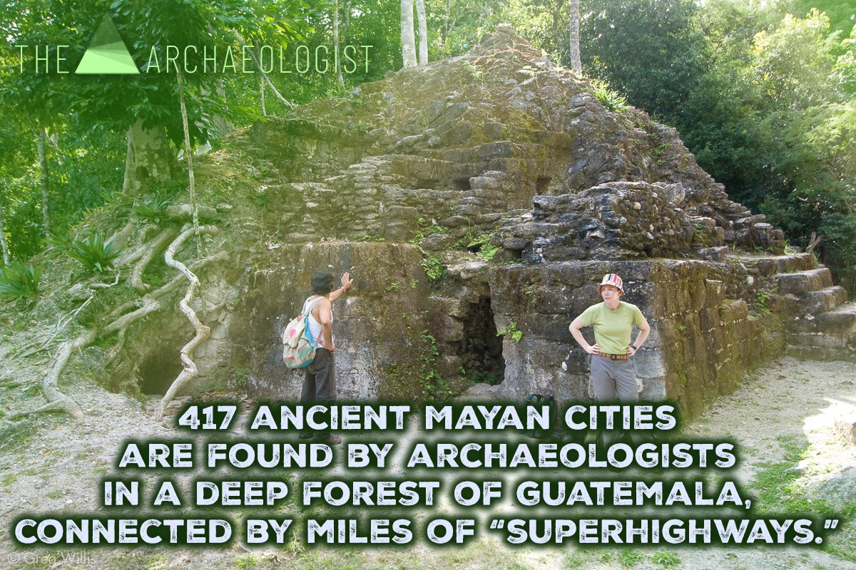
417 ancient Maya cities are found by archaeologists in a lost realm, connected by kilometers of "superhighways"
417 prehistoric Maya cities are found by archaeologists buried in isolated forests, connected by miles of "superhighways," in a vanished universe. The "first motorway system in the world" is what scientists are referring to.
Researchers from a joint US-Guatemalan archaeological study revealed in an interview with The Washington Post that they had discovered 417 cities with an estimated 3,000-year history that were connected by 110 miles of "superhighways."
This finding is causing historians to reevaluate their understanding of the ancient Mayan civilization. According to the Post, the finding of a network of cities and highways, hydraulic systems, and agricultural infrastructure indicates that societies in Central America were more developed than previously thought.
These findings "reflect socio-economic organization and political power," the research claims.

The Mayans, who were formerly thought of as a nomadic, hunter-gatherer culture, lived in the pre-classic era, which dates back to 1,000 B.C., during which time the lost world first appeared.
According to Richard Hansen, the main author of the paper and adjunct research professor of archaeology at Idaho State University, this find from the El Mirador jungle region in southern Guatemala is a "game changer."
On the border between Mexico and Guatemala, the discovery was made in a remote tropical jungle. The Post claims that only a helicopter can make the challenging 40-mile journey through the dense rainforest, which is home to jaguars and snakes.
With some of the largest buildings ever built, the preclassic period was one of exceptional complexity and architectural expertise, according to Hansen.
According to him, the research has revealed "a vast volume of human history that we've never known."
Since 2015, the team has been mapping the regions of Central America using lidar technology, a crucial archaeological laser mapping technique, to show the smallest features, such as old vegetation. The team includes scientists from the US and Guatemala.

© 2008 Greg Willis
According to the study, it gave scientists access to views of ancient dams, reservoirs, pyramids, platforms, causeway networks, and even ball courts.
Enrique Hernández, an archaeologist at San Carlos University in Guatemala City and a co-author of the research, told the Post that if this project goes further, it might have the same historical impact as the Egyptian pyramids.

Illustration by Dimosthenis Vasiloudis
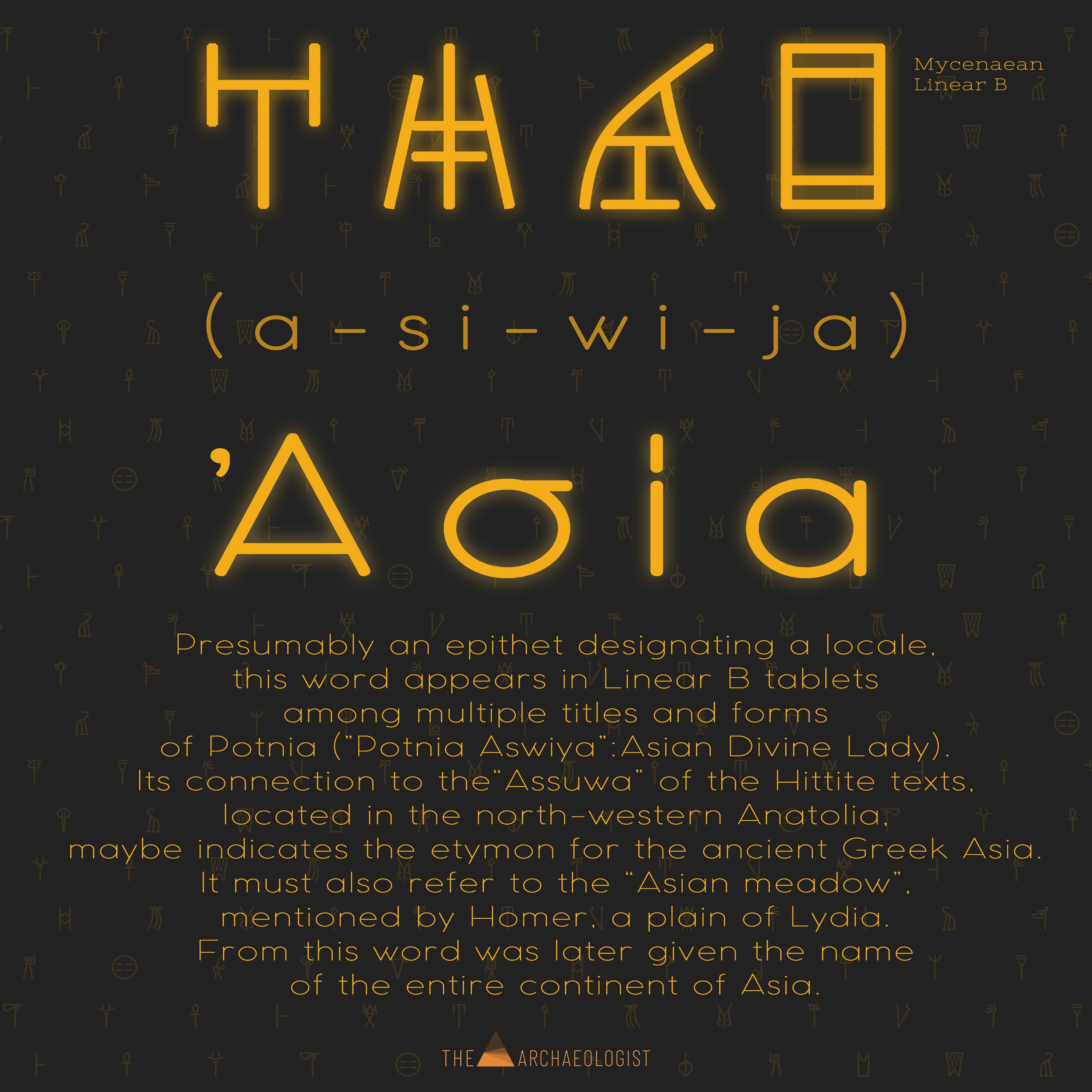
Asia: The Evolution of a Name from Mycenaean Antiquity to Contemporary Geography
How the Mycenaean epithet “Aswiya/Asia” was primarily a place name and later became the name of an entire continent.
The vast and diverse continent of Asia, comprising an astonishing breadth of cultures, languages, and landscapes, owes its name to an ancient epithet nestled in the annals of Mycenaean civilization. The term 'Asia” has undertaken a remarkable journey, originating as the humble Mycenaean epithet 'Aswiya' and transforming through the passage of time and civilizations to define the most populous continent on Earth. This fascinating odyssey of a single name serves as a microcosm of our evolving understanding of geography, politics, and cultural identities throughout history.
Origins of the Mycenaean epithet "Aswiya"
The term 'Aswiya,' as found in the Mycenaean records, is closely associated with the Hittite and Luwian term 'Asuwa,' which denoted a confederation of states in western Anatolia during the late Bronze Age. This epithet was documented in a series of tablets discovered in the Mycenaean palatial archives, such as those in Pylos and Knossos. The tablets provide a glimpse into the intricate diplomatic relationships, trading networks, and power dynamics between these ancient civilizations.
The original geographical designation of 'Aswiya' or 'Asuwa' is believed to have been relatively limited, referring primarily to regions on the Aegean Sea's eastern coasts and western Anatolia. The term's precise location remains a subject of scholarly debate, but it is generally agreed that it centered around the Troad and extended southward along the Aegean coastline.
'Aswiya' becomes 'Asia'
The evolution of the term 'Aswiya' into 'Asia' is a testament to the dynamic interplay of language, geography, and history. Over centuries, as civilizations rose and fell, the term 'Asia' began to be used by the Greeks in a broader context than its original Mycenaean designation. The Ionian Greeks, residing in the western part of Asia Minor, were among the first to use 'Asia' to describe the lands to their east, initially referring to the areas ruled by the Persian Empire.
The Achaemenid Persians themselves seem to have adopted a version of the term, using “” to refer to the province that roughly corresponds to modern-day Turkey. This Perso-Greek usage of 'Asia' became increasingly prevalent throughout the Hellenistic period, especially after Alexander the Great's conquests, which spread Greek culture and language far and wide.
The Greeks passed it on to the Romans
As the torch of empire passed from the Greeks to the Romans, so too did the term 'Asia.' The Romans initially used 'Asia' to denote the province of Asia Minor, their first acquisition in Anatolia, conquered in the 2nd century BCE. This Roman province of 'Asia' comprised most of western Anatolia and was one of the wealthiest and most densely populated regions in the empire.
However, as the Roman Empire expanded eastward, incorporating vast territories spanning three continents, the term 'Asia' began to be applied to an increasingly large geographical area. By the time of the late Roman Empire, 'Asia' had become a catch-all term for the lands to the east of the Roman world, encapsulating the enormity and diversity of the continent that we now know as Asia.
From the Romans to the Modern West
The term 'Asia,' as we understand it today, continued to evolve well after the fall of the Roman Empire, owing much to the advancements in geographical knowledge and global exploration in the subsequent centuries. During the Middle Ages, European explorers and cartographers began using 'Asia' to refer to the vast lands east of the Ural Mountains, the Caucasus, the Caspian Sea, and the Black Sea, reflecting a more modern understanding of continental boundaries. As the Age of Discovery dawned in the 15th century, propelled by advancements in navigation and seafaring, 'Asia' started encapsulating regions even further east, including the Indian subcontinent, the Far East, and the islands of the Pacific. This continental understanding was eventually formalized in the Western tradition through the works of influential scholars and geographers, such as Ptolemy and later, Mercator. The once Mycenaean toponym, 'Aswiya” has thus journeyed across millennia through the lenses of Greeks, Persians, Romans, and countless others before being adopted by the modern Western world to represent an incredibly diverse continent rich in culture, history, and natural splendor.
Thus, the transformation of 'Aswiya' into 'Asia' presents a riveting narrative that unveils the fluidity of cultural exchange and the evolution of geographical cognition. It reminds us that every term we use, even those defining our continents, carries within it an incredibly rich tapestry of historical, cultural, and linguistic shifts. The story of 'Asia”—from its roots in the Bronze Age Aegean world, through the Greeks, Persians, and Romans, and into the cartographic distinctions of the modern Western world—provides us with a unique lens to appreciate the intricate interplay of time, language, and history. Today, 'Asia' stands as a testament to the enduring power of names and their capacity to encapsulate and convey the vast complexities of human civilization and its geographical understanding.
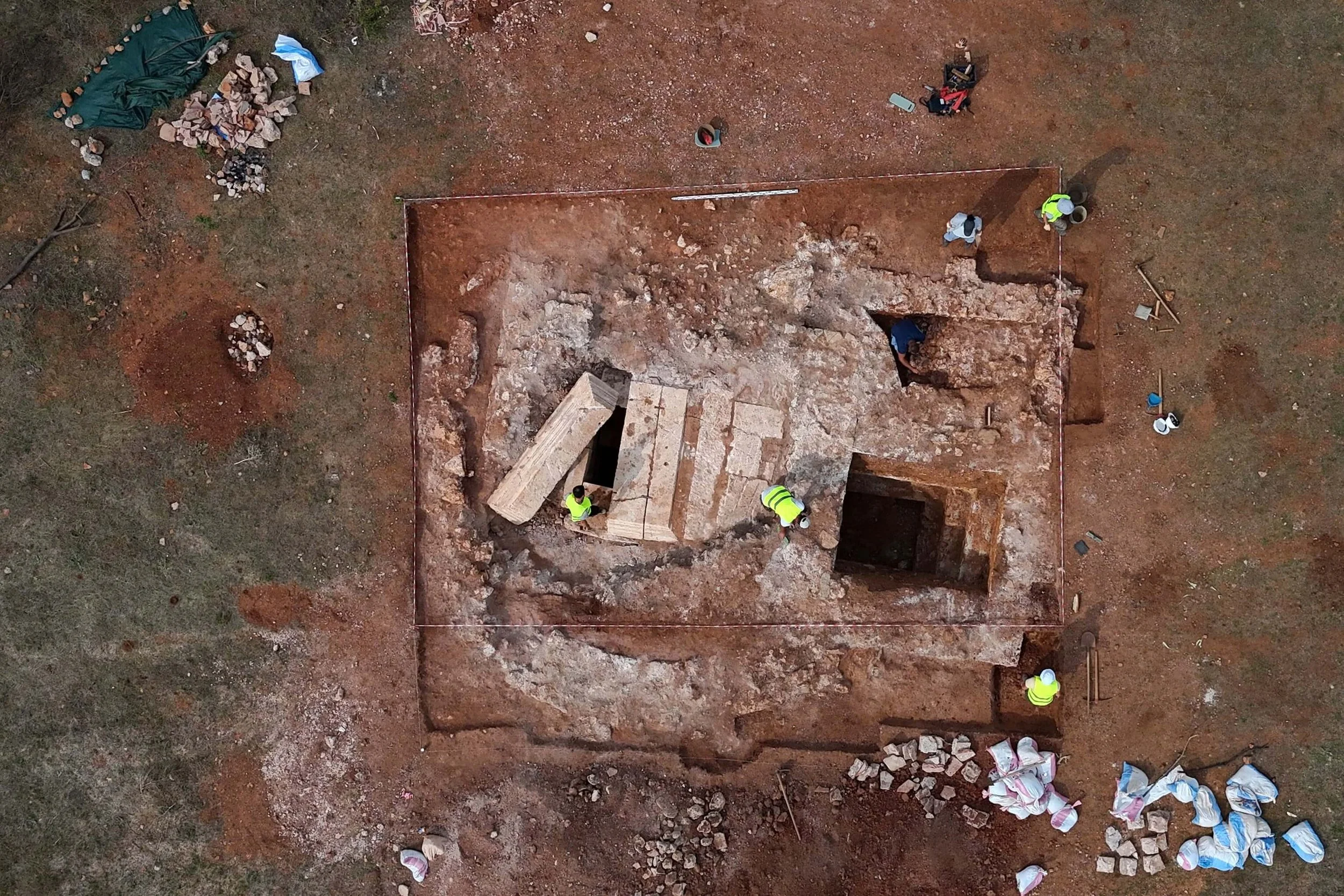
Archaeologists uncover a massive underground city beneath the Grand Canyon
Archaeologists have made a shocking discovery beneath the Grand Canyon, uncovering a vast underground city of unknown origin and purpose. The size and complexity of the city have left experts baffled and have sparked theories of a lost civilization. Join us as we delve into the mystery of this massive underground discovery.
The Smithsonian Institute, under the direction of Professor S. A. Jordan, is currently conducting extensive explorations of an underground citadel found in the Grand Canyon. These explorations aim to uncover every detail of this ancient site and to understand the history of the people who lived there. The team is delving nearly a mile underground, about 1480 feet below the surface, into the long main passage and finding multiple chambers with many passageways branching off like the spokes of a wheel.
Several hundred rooms have been discovered, accessible through passageways leading from the main passage. One passageway has been explored for 854 feet and another for 634 feet. The recent finds include artifacts that have never been known to be native to this country, leading scientists to believe that they originated in the orient. In addition, war weapons, copper instruments, and other tools found are sharp-edged and hard as steel, indicating that the people who inhabited this site had reached a high level of civilization.
Graham Hancock Reveals The Terrifying Truth About The Pyramids
In the following video we will investigate the terrifying truth about the Pyramids with Graham Hancock. Watch the video to find out more!
Mind Blowing Colorized Photos From History (Animated)
In this video today, we are going to see rare historical portraits, brought to life by mind blowing colorizations and facial animations using AI stuff. We never cease to get fascinated by old black and white photos in our history, that seem to portray a world so distant to us today. But with new technology and artistic skills of few individuals, this gloomy world has been brought to us much closer and pretty much alive again, by adding colors to it, in most spectacular of ways. In addition to this, I have added a subtle facial animations using Artificial Intelligence algorithms, that is going to blow you away.
Truth about the White Slave Trade
The Barbary pirates of North Africa attacked the coastal northern Mediterranean launching attacks against Britain, France, Italy and Sicily. In their feverish search for slaves a few pirates even went as far as the coast of Iceland, raiding inland to kidnap people and bring them back to North Africa.
From the 1500s to the 1800s it is estimated that one million white Europeans, to include those captured at sea as well as through land raids abroad were enslaved. Many of these were Americans captured at sea.
Australia Discovers a Long-Extinct Sea Scorpion That Can Reach 2 Meters in Length
A Queensland museum has uncovered a brand-new, extinct species of sea scorpion.
The newest species of sea scorpion, also known as eurypterids, was identified by Queensland Museum using a fossil "cold case."

The Woodwardopterus freemanorum is Queensland's first fossil representation of a sea scorpion.
The sea scorpion fossil was first found in the 1990s on Nick Freeman's family farm in the vicinity of Theodore, Queensland. The species would have been enormous when it once inhabited the Earth's oceans, according to researchers.
According to a statement from the museum, the new creature discovered in Theodore was a huge behemoth that most likely measured a meter in length and lived in freshwater lakes and rivers in the Theodore region, according to 9News.
When informed of the find, the museum's paleontology team was perplexed and unsure of which group of animals the fossils belonged to, making it a "cold case" for specialists.
The fossil of the now-extinct sea scorpion served as Dr. Andrew Rozefelds' focus as he spent a significant portion of the COVID-19 closures revisiting numerous fossil cold cases.
It was first categorized as a "Too-Hard Basket," according to Dr. Rozefelds, but the closures gave him the chance to investigate and evaluate some of the fossil collections housed in the museum, with the sea scorpions piqueing his interest the most.
He adds that based on his preliminary investigation, he came to the conclusion that the fossil belonged to some kind of arthropod. The fossil's location and ornamentation are similar to those of eurypterids.
They identified the species of the "cold case" fossil specimen from Theodore by working together with his German colleagues, Dr. Rozefelds and Dr. Markus Poschmann.
According to Dr. Rozefelds, using established dates for volcanic sediments preserved in the coal of the fossil allows for the most exact measurement of the Theodore sea scorpion. The specimen dates back approximately 252 million years. The scientists conducted considerable research on the specimen and found that it belonged to the final eurypterid species known to have existed anywhere on the world. As a result, the fossil was created just before the end-Permian extinction. Together with other animal species of the time, the eurypterid group vanished from the earth. One of the biggest predators in the lakes and rivers of Theodore would have been the extinct species of sea scorpion.
Eurypterids; The Giant Prehistoric Sea Scorpions
The Yale Peabody Museum describes the extinct Eurypterids as a group of chelicerates or arthropods that were closely related to modern spiders, scorpions, horseshoe crabs, mites, and ticks. These animals, which are frequently found in Silurian-aged rocks, flourished on Earth for more than 200 million years before succumbing to extinction 250 million years ago at the end of the Permian.
The only eurypterids that can swim over huge open oceans are sea scorpions. The largest arthropods are pterygotid eurypterids, which can grow to lengths of more than eight feet.
The Secret Missions Into The Great Pyramids
In the following video we will be talking about the secret missions into the Great Pyramids. Enjoy!
4 Craziest Roman Bridges that Actually Existed
This video covers some of the most impressive bridges constructed by the Ancient Romans. Whether it was to make war or trade, no river was deep or wide enough to act as a barrier for the great Empire. The Romans not only possessed some of the most skilled engineers and architects of their time, but also the sheer man power of the disciplined legions to make their creations come to life!
Scientists New Discovery In The Sahara That Changes Everything
The Sahara is an inhospitable place since its one of the driest and hottest places on earth, it covers an area larger than the USA yet it has one of the lowest population densities with roughly 1 person per square mile. Approximately 25 percent of the Sahara's surface is covered by sand sheets and dunes. Other geographical features include, salt flats, gravel planes and plateaus.
There are numerous rivers that originate outside of the Sahara but then enter the Sahara through underground waterways or by contributing to sources of surface water such as an oasis. This allows for hardy plants, animals and people to survive in this region, particularly in the Sahel where there are a further 44 million inhabitants. The Sahel literally means the Shoreline where the desert in the north transitions between the humid savannas to the south.
During the dry season, this region becomes extremely arid and barren, however in the wet season, the desert blooms, allowing for people to be able grow crops and feed their livestock, these seasonal changes were regular and predictable for centuries however since the 1950s there has been a 30% decrease in rainfall which reached record lows during the droughts of the 1970s and 80s ever since droughts have become more frequent.
This land loss has been the main driver of many other problems such as hunger, poverty, unemployment, forced migration, conflict and an increased risk of extreme weather events related to climate change.
Restoring degraded land back to productive good health is a huge opportunity. It brings big social and economic benefits to rural farming communities. This is why the country Niger, with 80% of its territory in the Sahara desert has been making some astonishing Agriculture developments turning large areas suffering from desertification into agricultural fields.
They have been using innovative water harvesting techniques allowing them to restore over 200 million trees over 5 million hectares of land benefiting over 2.5 million people.
This transformation can be called a major accomplishment for a country especially when a country only receives an average of 6.5 inch of rainfall a year.
In today's video we are going to tell you how and why Niger is turning its deserts into huge farmlands.
10 Dangerous Islands You Should Never Set Foot On
Islands are usually associated with breathtaking scenery and tranquil beaches, but some islands have a dark side that makes them too dangerous to explore. In this video, we'll take you on a journey to some of the most hazardous islands in the world, where natural disasters, deadly creatures, and human activity have made them unsafe for travelers.
Stonehenge-like building discovered beneath Lake Michigan that dates back 9,000 years
Archeologists were looking for shipwrecks in Lake Michigan when they stumbled onto something much more fascinating than they had anticipated.

Archaeologists were looking for shipwrecks in Lake Michigan when they came across something much more remarkable than they had anticipated: a boulder with a mastodon carving on it and a group of stones stacked like Stonehenge.
Οbserving the Water
In contemporary archaeology, remote sensing techniques are frequently used; researchers constantly search lakes and the ground for undiscovered buildings. Archeologists unearthed a prehistoric surprise when searching for shipwrecks in Lake Michigan's Grand Traverse Bay at a depth of roughly 40 feet. A trained eye can identify what it is by looking at the sonar scan photographs in this article. They also found sunken boats, automobiles, and even a pier from the Civil War.
During a news conference in 2007 with images of the boulder on display, Mark Holley, a professor of underwater archaeology at Northwestern Michigan University College who made the find, remarked, "When you see it in the water, you're inclined to say this is totally real." "But, we need the professionals to visit and confirm that.

The marked boulder measures roughly 5 feet in length and 3.5 to 4 feet in height. A surface with multiple fissures is visible in photos. The ones resembling what might be a petroglyph stood out, even though some might be natural and others seem to be human-made, according to Holley.
When taken as a whole, they, according to him, resemble the outline of a mastodon, complete with back, hump, head, trunk, tusk, triangular-shaped ear, and sections of legs.
According to Greg MacMaster, head of the underwater preservation council, "We couldn't believe what we were seeing."

Before certifying the marks are an ancient petroglyph, experts who have seen images of the boulder with the mastodon markings have requested more proof, according to Holley.
He stated, "They want to actually see it. However, he continued, "Petroglyph experts typically don't dive, so we're hitting into a bit of a stumbling block there."
If confirmed, the would-be petroglyph could date back as far as 10,000 years, which would put it in line with the presence of both humans and mastodons in the upper Midwest during the post-Ice Age. If the formation were real, it wouldn't be totally out of the ordinary. There are stone circles and other petroglyph sites nearby.
The discovery was made a few years ago, and surprisingly, there isn't much information online about it. But, I'll make sure to update this piece as soon as I can get my hands on more details. Who is from Michigan, then?