• MAIN PAGE
  • LATEST NEWS
    • Lost Cities
    • Archaeology's Greatest Finds
    • Underwater Discoveries
    • Greatest Inventions
    • Studies
    • Blog
  • PHILOSOPHY
  • HISTORY
  • RELIGIONS
    • Africa
    • Anatolia
    • Arabian Peninsula
    • Balkan Region
    • China - East Asia
    • Europe
    • Eurasian Steppe
    • Levant
    • Mesopotamia
    • Oceania - SE Asia
    • Pre-Columbian Civilizations of America
    • Iranian Plateau - Central Asia
    • Indus Valley - South Asia
    • Japan
    • The Archaeologist Editor Group
    • Scientific Studies
    • Aegean Prehistory
    • Historical Period
    • Byzantine Middle Ages
    • Predynastic Period
    • Dynastic Period
    • Greco-Roman Egypt
  • Rome
  • PALEONTOLOGY
  • About us
Menu

The Archaeologist

  • MAIN PAGE
  • LATEST NEWS
  • DISCOVERIES
    • Lost Cities
    • Archaeology's Greatest Finds
    • Underwater Discoveries
    • Greatest Inventions
    • Studies
    • Blog
  • PHILOSOPHY
  • HISTORY
  • RELIGIONS
  • World Civilizations
    • Africa
    • Anatolia
    • Arabian Peninsula
    • Balkan Region
    • China - East Asia
    • Europe
    • Eurasian Steppe
    • Levant
    • Mesopotamia
    • Oceania - SE Asia
    • Pre-Columbian Civilizations of America
    • Iranian Plateau - Central Asia
    • Indus Valley - South Asia
    • Japan
    • The Archaeologist Editor Group
    • Scientific Studies
  • GREECE
    • Aegean Prehistory
    • Historical Period
    • Byzantine Middle Ages
  • Egypt
    • Predynastic Period
    • Dynastic Period
    • Greco-Roman Egypt
  • Rome
  • PALEONTOLOGY
  • About us

Boomerang Found in Polish Cave May Be the Oldest Ever Discovered – And It's Made from Mammoth Ivory

July 14, 2025

A 40,000-year-old hunting tool is challenging what we thought we knew about Ice Age ingenuity.

An international team of researchers has uncovered compelling new evidence that a mammoth ivory boomerang found in a cave in southern Poland could be the oldest known boomerang ever discovered. Their findings, recently published in PLOS ONE, suggest this sophisticated hunting weapon may date back as far as 42,000 years—making it a remarkable testament to early human innovation in Ice Age Europe.

An Ancient Discovery Revisited

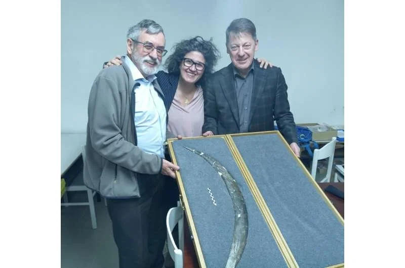
The boomerang was originally unearthed in 1985, deep inside Obłazowa Cave in the Western Carpathians. Measuring 72 cm in length and carved from mammoth tusk, it featured a curved, flattened design nearly identical to the throwing sticks still used by Australian Aboriginal peoples today.

At the time of its discovery, the artifact was recognized as highly unusual—but its true age remained uncertain. An early radiocarbon test gave an estimate of 18,000 years, but this result was later called into question due to contamination from conservation chemicals.

Now, nearly four decades later, the mystery surrounding the boomerang’s origin may finally be solved.

New Clues from Bones, Not the Boomerang

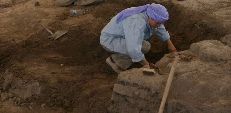
Because the boomerang itself was too fragile to be tested again, the research team turned to indirect dating methods. They analyzed animal bones and a human thumb bone excavated from the same archaeological layer as the boomerang—Layer VIII of Obłazowa Cave.

One standout find: the human finger bone, which was genetically confirmed to be from a Homo sapiens individual who lived approximately 31,000 years ago.

More crucially, radiocarbon dating of numerous animal bones from the same layer—many of them also shaped by human hands—yielded an average age of roughly 41,500 years. Using advanced statistical modeling, the researchers estimate the boomerang dates between 39,280 and 42,290 years ago.

A Weapon Carved from a Mammoth

The boomerang wasn’t just old—it was also made from one of the Ice Age’s most iconic animals. Mammoth ivory, prized for its strength and flexibility, would have required serious skill to carve.

“This wasn’t just a shaped stick,” notes lead researcher Prof. Sahra Talamo. “It was a complex tool that required deep knowledge of materials and aerodynamic design.”

Its arched shape and flattened cross-section are hallmarks of boomerangs designed for straight flight, commonly used to hunt small game or birds—not necessarily to return to the thrower.

A Glimpse Into Prehistoric Intelligence

The discovery reshapes our understanding of early humans in Europe. If confirmed, this would push back the timeline for advanced toolmaking in the region by thousands of years, placing Ice Age Europeans on par with their more famous hunter-gatherer cousins in Australia and Africa.

“This find challenges assumptions that such sophisticated weapons were only developed in later, warmer periods,” says co-author Prof. Paweł Valde-Nowak.

Where It Was Found: Obłazowa Cave

Obłazowa Cave, located in Poland’s Podhale Basin, is a rich archaeological site with layers dating to multiple prehistoric cultures, including the Aurignacian, Szeletian, and Mousterian periods. It’s yielded tools, ornaments, and even a rare Paleolithic burial.

Now, it can add the world’s oldest known boomerang to that list.

What’s Next?

While direct testing of the artifact remains impossible, the authors emphasize that more discoveries like this may still be waiting beneath Europe’s soil—or inside museum storage rooms.

“We now have a more refined model for dating such finds,” says Prof. Adam Nadachowski. “And we hope this encourages further reexaminations of Ice Age tools using modern technology.”

When Ideas Traveled Further Than People: New Study Reveals How Farming Spread Across Ancient Anatolia

July 14, 2025

A groundbreaking study combining archaeology and ancient DNA is rewriting what we know about how farming and sedentary life spread through prehistoric Anatolia.

The rise of agriculture—arguably one of the most transformative shifts in human history—didn’t always move with migrating people. Instead, new research shows that in parts of ancient Anatolia, it was ideas, not farmers, that traveled the furthest.

This revelation comes from a Turkish-Swiss collaboration, published in Science, where researchers used a rare combination of ancient genome sequencing and large-scale archaeological data to untangle a long-standing debate: Did farming spread by cultural diffusion or population movement? The answer is more nuanced than previously imagined.

The Birthplace of Farming and a Puzzle of Movement

Modern-day Turkey, home to the Fertile Crescent’s western edges, was central to the Neolithic revolution. Around 10,000 years ago, communities here began the radical shift from hunting and gathering to settled village life with domesticated plants and animals.

Until now, scientists assumed that this change spread into neighboring regions primarily through migration. But the new study—led by experts from Middle East Technical University, Hacettepe University, and the University of Lausanne—suggests a more complex story.

“In some regions of West Anatolia, we see major cultural transitions, but without evidence of new populations arriving,” says Dr. Dilek Koptekin, lead author. “People didn’t move—but their ideas did.”

Genetics Meets Pottery: A Revolutionary Method

To reach these conclusions, the team sequenced the oldest known genome from West Anatolia, a 9,000-year-old individual, along with 29 other newly recovered ancient genomes. Surprisingly, across 7,000 years of settlement, the genetic signatures remained strikingly consistent—even as the material culture changed drastically.

“People moved out of caves, built homes, adopted new tools and rituals—all without being replaced by incoming populations,” explains Dr. Anna-Sapfo Malaspinas, a computational biologist at UNIL. “This clearly points to cultural transmission over mass migration.”

But the study didn’t stop with genetics.

The researchers also developed a novel approach to quantify archaeological data—assigning numerical values to artifacts like pottery styles, tools, and architectural features from hundreds of published sources. This allowed them to systematically match cultural shifts with genetic data from the same regions and timeframes.

“We finally had a way to directly compare how cultural practices spread in relation to biological ancestry,” says archaeologist Çiğdem Atakuman from METU. “This was a first.”

Not All Pots Mean People

The findings challenge the long-standing archaeological saying: “Pots don’t equal people.”

In West Anatolia, at least, the saying holds true. Communities took on new lifestyles without being genetically replaced. Farming and village life emerged not from colonization, but from cultural influence—perhaps via trade, seasonal visits, or symbolic exchanges.

However, other regions told a different story.

Around 7,000 BCE, DNA reveals clear signs of population movement and admixture in central and Aegean Anatolia. Here, both genes and ideas traveled together, signaling a new wave of migrations that would later push into Europe.

“The Neolithic was not one-size-fits-all,” says Dr. Füsun Özer of Hacettepe University. “It was a mosaic of local adaptations, cultural exchanges, and, in some places, true migration.”

Why It Matters: A New Model of Human Change

The study’s broader impact lies not just in what it reveals about the Neolithic, but how it was done. By integrating archaeological and genetic data at this scale, the researchers offer a new model for understanding ancient human transitions—one that moves beyond simplistic narratives of replacement or isolation.

“Humans don’t need a crisis or invasion to change,” says Koptekin. “We’re naturally innovative, curious, and open to new ways of life.”

A Call for Global, Inclusive Research

The study also highlights the value of locally led research. Unlike many high-profile genetics papers that center on labs in North America or Western Europe, this project was conceived and led by researchers in Turkey—the very region under study.

“It shows how powerful science can be when research is rooted in the communities and landscapes it investigates,” says Malaspinas. “This should be the model moving forward—more inclusive, more global, and more collaborative.”

Bottom Line:

The shift to farming in Anatolia wasn’t a single process—it was a patchwork of movement, tradition, and innovation. In many places, ideas outpaced people, changing the world without changing who lived in it.

This study not only reshapes our understanding of the Neolithic—it also opens the door to new, more sophisticated ways of exploring how humans adapt, exchange, and evolve.

First Hominin Fossils Recovered from Submerged Sundaland: A Game-Changer in Southeast Asia's Human Prehistory

July 14, 2025

For the first time ever, hominin fossils have been found beneath the sea floor of Sundaland—offering rare, tangible evidence that our early human ancestors once roamed these now-submerged lowlands.

A recent study led by Dr. Harold Berghuis and published in Quaternary Environments and Humans reveals that one of these fossils—recovered during a routine construction dredging operation—belongs to Homo erectus, a key player in the human evolutionary story. These are the first hominin fossils ever recovered from the submerged regions of Sundaland, a vast expanse of land that connected parts of Southeast Asia during the Pleistocene era.

The Forgotten Land Beneath the Waves

Much of what we know about ancient hominins in Southeast Asia comes from fossils found on present-day land: Java, Flores, Luzon. But during the Ice Age, sea levels dropped dramatically, exposing a massive landmass—Sundaland—that linked modern-day Indonesia, Malaysia, and parts of mainland Asia. This now-submerged region was once a continuous stretch of plains, valleys, and river systems, potentially teeming with hominins like Homo erectus.

Despite this potential, the seabed has remained largely unexplored. The main obstacle? Access. Excavating underwater sediments is expensive and usually only happens during industrial projects—like the one that led to this discovery.

How Construction Uncovered a Deep Past

In 2014–2015, the port company Berlian Manyar Sejahtera (BMS) initiated a large-scale land reclamation project near Surabaya, Indonesia. Over 5 million cubic meters of seabed sand were dredged to create a 100-hectare artificial island for cargo operations.

Later inspection of the newly formed island revealed an unexpected treasure: thousands of fossilized vertebrate remains—6,732 specimens in total—including two hominin fossils, now dubbed Madura Strait 1 (MS1) and Madura Strait 2 (MS2).

What the Fossils Tell Us

After rigorous comparative analysis, Dr. Berghuis and his team identified MS1 as belonging to Homo erectus, specifically resembling late Middle Pleistocene Javanese individuals dating to 140,000–92,000 years ago. MS2 was harder to pin down but appears to belong to an archaic Homo species.

This discovery extends the known range of Homo erectus beyond Java, suggesting they spread across Sundaland’s now-submerged lowlands during the Middle Pleistocene.

“It’s the first solid fossil evidence from underwater Sundaland,” said Dr. Berghuis. “It proves that hominins—specifically Homo erectus—occupied these lowland plains before they were swallowed by the sea.”

Ancient Landscapes, Modern Mysteries

Geological analysis places the fossil site within Marine Isotope Stage 6 (MIS6)—a glacial period around 160,000 to 120,000 years ago when sea levels were lower, and Sundaland was exposed.

The researchers ruled out the possibility that the fossils were reworked from older deposits. The sediment layers, depth of the site, and uniform mineralization of the fossils all point to in-situ deposition rather than later disturbance.

The broader fossil assemblage paints a picture of a dry, open landscape, populated by now-extinct species like Stegodon trigonocephalus and Duboisia santeng—herbivores that would have shared their habitat with hominins.

The High Cost of Discovery

Why haven’t more fossils been found in Sundaland’s submerged terrain?

“Extracting seabed sand is very expensive,” Dr. Berghuis notes. “We typically only get access to these materials during large-scale construction. That’s why it’s critical for scientists to collaborate with port authorities and developers.”

He adds, “We may one day see another dredging operation nearby. If that happens, having paleontologists involved from the start could be crucial.”

Why It Matters

This find fills a significant gap in our understanding of early human migration in Southeast Asia. It supports the idea that hominin populations moved across Sundaland—not just between isolated islands—and highlights how much of human history is still hidden beneath the waves.

It also raises new questions:

  • How far did these early humans spread?

  • What other species may lie buried beneath the seabed?

  • And how much more are we missing simply because of lack of access?

One thing is clear: Sundaland holds secrets, and we’ve only just begun to unlock them.

Did Women Rule Çatalhöyük? DNA Suggests a Matrilineal Society in One of the World's Oldest Cities

July 14, 2025

A groundbreaking genetic study of Neolithic remains from Çatalhöyük, one of the earliest known cities in the world, is challenging long-held assumptions about ancient social structures. The analysis suggests that female lineage played a central role in household formation—hinting at a matrilocal or even matrilineal society nearly 9,000 years ago.

Life in Neolithic Anatolia

Located in central Turkey near modern-day Konya, Çatalhöyük thrived between 7100–5500 BCE. The site is famed for its densely packed mudbrick homes and rich archaeological layers—each house built atop the ruins of the previous. The community's dead were buried beneath their floors, giving researchers a direct window into the social fabric of this ancient world.

The Big DNA Breakthrough

In a collaborative international project, scientists examined the DNA of 131 individuals buried at Çatalhöyük. Using advanced analysis of the petrous bone—a dense part of the skull ideal for DNA preservation—they discovered something striking: people buried in the same house were more closely related through the maternal line than the paternal.

“This suggests that women were more important in forming households,” says Dr. Eva Rosenstock from the University of Bonn.

In other words, it appears that people lived in matrilocal households, where women stayed put and men possibly moved in—a setup radically different from the later patriarchal norms that would dominate much of Eurasian history.

Not Quite a Matriarchy—but Close?

While the researchers stop short of calling Çatalhöyük a true matriarchy—where women held political or institutional power—there are plenty of signs suggesting high female status. Women were buried with richer grave goods, and early excavators like James Mellaart noted the abundance of female figurines at the site, long speculated to indicate goddess worship or female-centered rituals.

“It’s not a matriarchy in the classic sense,” Rosenstock clarifies, “but the archaeological and genetic evidence points to women having a central social role.”

Two Infants, One House, No Kinship

Among the key findings were two newborn skeletons excavated from the West Mound. Though found buried beneath the same home, genetic analysis showed they weren’t closely related. This reinforces earlier theories that Çatalhöyük’s households weren’t based purely on blood ties, but perhaps on shared economic, cultural, or spiritual bonds.

Continuity and Change: East and West Mounds

For decades, scholars believed there was a cultural break between Çatalhöyük’s East and West Mounds. But the genetic similarities between the two infant skeletons and older East Mound remains suggest otherwise. “It’s strong evidence of cultural and genetic continuity,” says Rosenstock.

So why was there a brief disruption around 6000 BCE when the West Mound was first built? That mystery remains unsolved.

Why It Matters

This study adds fresh weight to an ongoing academic debate: Were ancient societies more gender-balanced—or even women-led—before the rise of patriarchal institutions? While Çatalhöyük may not have been a full-fledged matriarchy, it clearly operated on very different social principles than most of the ancient and modern world.

It also opens up new questions:

  • When did the shift to male-dominated structures happen across Europe and the Near East?

  • How did kinship systems evolve alongside agriculture, property, and inheritance?

  • And how many more clues are buried—quite literally—beneath our feet?

As scientific methods like archaeogenetics continue to evolve, so too does our understanding of who we are—and who we were.

Ancient Greeks in America? What Plutarch Reveals About a Forgotten Voyage to the New World

July 14, 2025

The idea that ancient Greeks may have reached North America sounds outrageous to many—but becomes intriguingly plausible when one closely examines the writings of ancient authors like Plutarch.
Researcher and philologist Panagiota Preka-Papadima has explored one of Plutarch’s most enigmatic passages, shedding new light on the possibility of Greek presence in the New World, centuries before Christopher Columbus.

Plutarch’s Passage and the “Great Islands”

In his work “On the Face in the Moon” (Περί του εν τω Προσωπώ της Σελήνης φαινομένου), Plutarch refers to a Greek colony located beyond the Atlantic Ocean. The text suggests that Greeks had sailed great distances and settled on islands near a massive continent “beyond the Great Sea.”

He also mentions waypoints on a maritime route, including:

  • The Islands of the Blessed (likely the Canary Islands);

  • A Great Island, which some interpret as Atlantis or possibly Iceland;

  • And finally, a continent located beyond the Pillars of Heracles (i.e., the Atlantic Ocean).

A Greek Colony in America?

Preka-Papadima highlights a striking phrase: “The Greeks sent colonists to lands beyond the Ocean.”
According to her, this cannot simply be dismissed as myth. Plutarch—a philosopher, historian, and priest at Delphi—was not known for fantastical storytelling.

She connects this account with astronomical references in the text. Plutarch describes time intervals, lunar positions, and star movements, adding a layer of credibility. He even claims the colony communicated with Delphi every 30 years, suggesting a structured and long-term exchange.

A Map of the Greeks’ Possible Route to America

Researchers have proposed a possible route, tracing the steps outlined in the passage—through the North Atlantic and toward the shores of North America.

Matching the Ancient Descriptions to the Americas

According to Preka-Papadima:

  • The distances, landmarks, and sequences described by Plutarch align remarkably well with locations in the North Atlantic—possibly leading to North America.

  • The description of a continent with fresh water and mild winds corresponds to areas like Canada and the Great Lakes.

  • The term “Ogygia” (used to describe the large landmass) may refer to ancient mythological realms—and could be linked to the idea of Atlantis.

Greek Seafaring Knowledge and Capabilities

This theory gains credibility when we consider that:

  • The Minoans and Mycenaeans were exceptional seafarers;

  • They possessed advanced astronomical knowledge and built ships capable of long-distance voyages;

  • Ships like the penteconter and evolving coastal charts show a higher level of sophistication than previously believed.

Skepticism and Challenges

Still, the theory faces significant challenges:

  • There is no definitive archaeological evidence of Greek presence in America—only indirect clues and controversial artifacts.

  • Many classical scholars interpret Plutarch’s text metaphorically rather than literally.

  • Others believe the “unknown lands” refer to Ireland, Scandinavia, or other parts of the then-known world.

Rejection or Rediscovery? A Modern Interpretive Shift

Preka-Papadima calls for a reassessment of ancient texts, guided by modern science—from geography and maritime technology to comparative mythology.

She urges scholars not to treat ancient references merely as myths, but as fragments of historical memory, preserved through oral and written traditions.

Myth or Reality?

The theory of a Greek colony in North America isn’t just another fringe hypothesis. It draws from:

  • Classical texts with precise descriptions,

  • Demonstrated maritime abilities of ancient civilizations,

  • And mythological parallels tied to real-world geography.

We may never know with absolute certainty whether ancient Greeks truly set foot in the New World.
But the fact that thinkers like Plutarch recorded such accounts—and that modern scholars like Preka-Papadima continue to explore them—keeps alive the possibility that our civilizational history is richer and deeper than we’ve ever imagined.

Note: Ogygia, or Ogygie, is the mythical island mentioned in Homer’s Odyssey as the home of the nymph Calypso, daughter of the Titan Atlas. Some later traditions associate it with Atlantis.

Ancient Peoples Claimed They Could Hear the Northern Lights — Now Science Says They Were Right

July 14, 2025

For centuries, Indigenous peoples living near Earth’s polar regions passed down legends, beliefs, and superstitions about the aurora borealis, also known as the Northern Lights.

To the Sámi people of Scandinavia, the lights were a source of awe and fear. Elders warned children never to disturb them, lest they be swept up into the sky. The Inuit of Greenland believed the aurora was a pathway to the heavens, where the spirits of the dead played ball with a walrus skull. In Finland, some believed Arctic foxes were responsible—running so fast across the mountaintops that their tails sent up sparks that lit the night sky.

But beyond myth and metaphor, there was one striking belief that united many of these cultures:

They claimed they could hear the lights.

Reports spoke of crackling, popping, and even a soft rustling sound, like rain falling from above.

As the Danish explorer Knud Rasmussen noted in 1932, one Greenlander told him the sound was made by "the souls running across the frozen sky."

Science Used to Say It Was Impossible

For decades, scientists dismissed the idea. The aurora occurs between 60 and 200 miles above Earth, in the ionosphere—a region so thin that it can’t effectively carry sound waves. Even if the lights somehow did make noise, it was believed the sound would dissipate long before reaching the ground.

So when people described hearing crackling or humming under the shimmering sky, researchers assumed it was either a psychological phenomenon or wishful imagination.

New Research Suggests Otherwise

But recent studies are challenging that skepticism.

Unto Kalervo Laine, a professor at Aalto University in Finland, once rejected the idea himself. However, in 2000, he and his team began investigating the ancient accounts, aiming to make sense of this seemingly impossible phenomenon.

Auroras occur when solar winds carry high-speed particles from the sun toward Earth, guided by our planet’s magnetic fields. These energetic particles collide with atoms in the upper atmosphere, creating dazzling displays of light around the magnetic poles.

But Laine’s theory takes us closer to the ground.

He explains that during auroral activity, a temperature inversion layer may form closer to Earth’s surface. In this layer, warm air traps cooler air underneath—along with negatively charged particles. These charges build up beneath a layer of positively charged particles.

Then, during an aurora event, a magnetic pulse may trigger a sudden discharge—producing the very crackling or popping sounds described in ancient lore.

Echoes of the Past, Confirmed by Science

This theory would explain why the sounds often occur at the same time as the lights and why generations of people believed they were hearing the sky itself "speaking" during these celestial events.

So while solar storms may trigger the aurora borealis, the ancient people weren’t imagining things when they said the lights could be heard.

As it turns out, those old legends weren’t just stories—they were science, waiting to be understood.

Rare Byzantine Coin Discovered at Historic Fortress—What It Reveals About the Region’s Importance and History

July 14, 2025

A rare gold coin from the Byzantine Empire, dating to the reign of Emperor Justin II (565–578 CE), was recently unearthed at a fortress site—offering valuable insight into the economic history of Byzantium and the strategic significance of the location.

A Treasure from the Early Byzantine Period

The coin was found at the Tuida Fortress, a site of major strategic importance during the early Byzantine period. Located in the northeastern part of Sliven, Bulgaria, the discovery was announced by the Regional Historical Museum of Sliven.

This find marks the fourth gold coin discovered at Tuida and is especially significant due to its rarity and historical context.

The Emperor Behind the Coin

Emperor Justin II was the nephew and successor of the famous Emperor Justinian I, continuing his uncle’s legacy of ambitious construction and territorial expansion. However, Justin II’s reign was also marked by mounting pressure from the Sassanid Empire in the east and the Lombards in the west.

His rule is historically notable not just for political and military developments, but also for reports of mental instability in his later years—leading his wife, Empress Sophia, and general Tiberius to take control of imperial affairs.

The Fortress of Tuida: A Sentinel Through the Ages

Perched atop Hisarlaka Hill, Tuida Fortress was part of the Stara Planina (Balkan Mountains) defense network. Initially constructed at the end of the Roman period, it was rebuilt during the early Byzantine era. It served as a key military and administrative hub and played a crucial role in the defense of the region throughout Roman, Byzantine, and medieval Bulgarian history—guarding trade routes and deterring invasions.

Details of the Discovery

Initially believed to date to Justinian I’s reign, the coin was confirmed—after cleaning and analysis—to belong to Justinian II’s rule. On its obverse (front side), the coin features a bust of the emperor holding an orb topped with the Roman goddess Victory (Nike).

The Latin inscription reads:

D N IVSTINVS P P AVG, which translates to:

  • D N = Dominus Noster = Our Lord

  • IVSTINVS = Justin (name)

  • P P = Perpetuus (or Perpetuus Pontifex) = Eternal

  • AVG = Augustus = The Revered One

Together: “Our Lord Justin, Eternal Augustus”—a traditional imperial title reflecting divine authority and sovereignty.

The reverse side bears the inscription: VICTORIA AVGGG ΘS, commonly seen on Roman and Byzantine coins. It breaks down as:

  • VICTORIA = Victory

  • AVGGG = Plural of Augustus, suggesting three emperors (possibly representing a triarchy or shared rule)

  • ΘS = Abbreviation from the Greek “Theos” = God or Divine

This side also features Emperor Justin holding an orb with Nike, gazing forward. Experts believe the coin was likely minted in Theopolis—the historical name for Antioch, one of the Byzantine Empire’s most significant cities.

Located in modern-day southern Turkey, near the Syrian border, Antioch was a major administrative, commercial, and religious hub during both the Roman and Byzantine eras. The “ΘS” mint mark supports the theory that the coin was struck at the Antioch mint, further enhancing the find’s historical and geographical importance.

Why This Find Matters

To date, archaeologists have uncovered 23 coins at Tuida during this season alone, ranging from the 2nd–3rd centuries CE to the 12th–13th centuries. These discoveries provide a wealth of information about continuous habitation and regional importance during centuries of political upheaval.

The discovery of this rare solidus of Justin II adds significantly to the numismatic and economic history of Byzantium. It also highlights Tuida Fortress’s role as a vital link in the empire’s defensive and administrative network during the early Byzantine period.

For historians and scholars alike, this gold artifact opens new windows into the rich cultural heritage of the Byzantine Empire in southeastern Europe, while reinforcing the legacy of Sliven—one of Bulgaria’s oldest continually inhabited regions.

Ancient Temple of a Lost Civilization Discovered — A Mysterious Culture Leaves More Questions Than Answers

July 14, 2025

On the southern shores of Lake Titicaca, in what is now Bolivia, more than a thousand years ago, one of the most powerful—yet enigmatic—civilizations of the Andes once thrived.

Known as the Tiwanaku, this culture is considered one of the earliest complex societies in the region and a forerunner of the Inca Empire. Despite their influence, the Tiwanaku mysteriously declined around 1000 CE, leaving behind a legacy clouded in mystery.

Now, a newly uncovered ancient temple by researchers from Penn State University and Bolivia may help illuminate the grandeur and influence of this lost culture that once dominated the Andean highlands.

A Discovery That Reshapes History

Published in the journal Antiquity, the find confirms that the Tiwanaku's territorial reach extended farther than previously believed. It also reveals how the civilization developed intricate economic and religious networks across an ecologically diverse region.

The temple, named Palaspata, after its surrounding area, lies nearly 130 kilometers south of the main archaeological site of Tiwanaku. Located atop a hill, it remained invisible to archaeologists for centuries, though known to local farmers.

A Strategic Location

According to lead researcher José Capriles, associate professor of anthropology at Penn State, the site’s location was no accident. Perched on high ground, Palaspata sits at a crossroads between three major trade routes: the highlands around Lake Titicaca to the north, the arid Andean plateau ideal for llama grazing to the west, and the fertile Cochabamba valleys to the east.

“This convergence of distinct ecosystems likely made Palaspata a hub of exchange and cooperation between diverse communities,” Capriles explains.

A Ceremonial Complex Hidden in Plain Sight

Using satellite imagery and drone photography, the research team digitally reconstructed the temple’s structure in 3D. The results revealed a ceremonial complex measuring roughly 125 by 145 meters, composed of 15 enclosed quadrants arranged around a central courtyard. Its alignment follows the solar equinox, suggesting a strong ritualistic function.

Although located 209.2 kilometers south of the main Tiwanaku site, Palaspata had never been fully explored—perhaps because of its seemingly unremarkable setting.

Signs of Ritual and Divine Legitimacy

The team unearthed fragments of ceremonial vessels (kerus) used for drinking chicha, a corn beer traditionally consumed during agricultural festivals. The presence of these items is significant, as maize does not grow at such altitudes—it must have been brought from the lower Cochabamba valleys.

This points to Palaspata not just as a religious center, but as a redistribution hub—a place where economic exchange was sanctioned through spiritual practices.

“In societies like the Tiwanaku,” Capriles notes, “religion was the common language that enabled collaboration across scattered communities. Even political and economic control was exercised through the divine.”

For Justo Ventura Guarayo, mayor of the nearby town of Caracollo, the discovery is more than academic. “This legacy had been completely forgotten—even by us,” he admitted.

From Forgotten Hilltop to National Treasure

Local authorities are now collaborating with the Bolivian government to preserve the site and promote it as a cultural and tourist destination. Experts like Capriles have committed to ensuring its protection and public recognition.

But as one mystery unfolds, new questions emerge:

  • How far did the Tiwanaku's influence truly stretch?

  • How exactly were their trade and religious networks organized?

Capriles remains cautious: “There’s still so much to discover. Sometimes, the clues are right in front of us—we just need to learn how to see them.”

Marble Caves: Chile’s Natural Wonder That Leaves Visitors in Awe

July 14, 2025

Tucked away in the heart of Patagonia, on the shimmering waters of General Carrera Lake—shared by Chile and Argentina—lies one of the most breathtaking natural wonders of the world: the Marble Caves, also known as Capillas de Mármol or “Marble Chapels,” and often referred to as Marble Cathedrals due to their majestic beauty.

These awe-inspiring caves are not the result of human design, but rather the work of nature's slow and steady hand. Formed over 6,000 years ago, the caves were sculpted by the gentle but persistent erosion of limestone, a sedimentary rock, by the lake’s waters. The result is a series of wave-like, flowing geological formations that seem almost otherworldly.

A Symphony of Light, Water, and Stone

The three most famous formations in the Aysén region are La Capilla (The Chapel), El Catedral (The Cathedral), and La Cueva (The Cave). Visitors are mesmerized by the way the crystal-clear turquoise waters interact with the natural light, casting dazzling reflections on the marble walls. These surfaces shimmer in shades of gray, white, green, and even yellow, creating a dreamlike, ethereal atmosphere inside the caves.

What makes the experience even more magical is its ever-changing nature. Depending on the time of day, season, weather, and angle of sunlight, the caves offer different visual spectacles—ensuring that no two visits are ever quite the same. It's no surprise that thousands of travelers from around the world flock to this hidden gem to witness its surreal beauty up close.

Accessing the Marble Caves

The only way to reach the caves is by boat or kayak, making the journey part of the adventure. Travelers must first arrive at the small town of Puerto Río Tranquilo, where they can join guided tours using small boats or kayaks that glide through the serene lake waters, bringing them into the heart of the marble labyrinth.

The full excursion typically lasts around two hours, allowing ample time for exploration, photography, and peaceful contemplation.

Best Time to Visit

The optimal time to visit is between December and March, when weather conditions are more favorable and the lake is calmer, making navigation easier and the experience safer and more enjoyable. During this period, the emerald and aquamarine hues of the lake contrast beautifully with the backdrop of the majestic Andes Mountains, offering a picture-perfect setting.

A Sanctuary for Wildlife

Beyond their visual splendor, the caves also provide shelter for various species of wildlife, including birds, fish, and even sea lions, adding another layer of wonder to an already unforgettable experience.

Researchers Create “Living Material” That Captures Carbon Dioxide

July 14, 2025

A groundbreaking innovation with the potential to transform building materials and environmental technology has been unveiled by a research team at ETH Zurich. The team has developed a new kind of living material—one that not only "breathes" but also actively captures carbon dioxide (CO₂) from the atmosphere. This novel material incorporates cyanobacteria, photosynthetic microorganisms among the oldest life forms on Earth, into a 3D-printable gel.

The result of this interdisciplinary approach—recently published in Nature Communications—is a living, growing material with dual carbon capture capability. Specifically, it stores CO₂ both by creating biomass and by forming inorganic compounds like carbonate salts. This dual function ensures more stable, long-term carbon storage.

A Material That Grows—and Captures CO₂

The new material can take various shapes through 3D printing and requires only light, artificial seawater, and CO₂ to grow. According to the researchers, it could one day be integrated directly into buildings, making carbon capture a built-in function of architectural infrastructure.

The key innovation lies in the cyanobacteria’s ability not only to absorb CO₂ and convert it into organic matter, but also to alter their chemical environment to form solid carbonate salts such as limestone. Researchers leveraged this process so that minerals deposit inside the material, reinforcing it over time. As a result, the initially soft material gradually hardens, gaining structural stability.

In tests lasting 400 days, the material continued to absorb CO₂, with most of the carbon stored in inorganic form—about 26 milligrams of CO₂ per gram of material. This is a significantly higher performance than other biological methods and is comparable to chemical carbon storage used in recycled concrete.

Designed for Performance and Longevity

The cyanobacteria are housed in a hydrogel—a water-rich polymer designed to allow light, CO₂, and nutrients to reach the cells. This setup keeps the microbes alive and active for extended periods. To boost performance, the team also optimized the geometry of the printed structures, increasing surface exposure to light and promoting capillary-driven nutrient distribution.

Dalia Dranseike, co-author of the study, emphasized that this design enabled the cyanobacteria to remain productive for over a year, showcasing the system's durability and viability.

This living material is expected to become a sustainable and energy-efficient solution for atmospheric carbon capture, complementing existing chemical methods. The research team plans to explore its use as a façade coating for buildings, offering continuous CO₂ absorption throughout the building’s lifespan.

From the Lab to Real-World Applications

The concept has already moved beyond the lab to its first real-world applications. At the Venice Architecture Biennale, the installation Picoplanktonics showcased 3D-printed structures made from the material, shaped like tree trunks up to three meters tall. These living sculptures can capture up to 18 kilograms of CO₂ per year—the equivalent of what a 20-year-old pine tree absorbs annually.

At the Triennale di Milano, another project titled Dafne's Skin explores the use of living materials as architectural coatings. Microorganisms grow on wooden tiles, forming a green patina that transforms weathering into an aesthetic and functional feature.

This living material is the result of the ALIVE (Advanced Engineering with Living Materials) initiative at ETH Zurich, which fosters collaboration among architects, biologists, engineers, and materials scientists. The aim is to develop new bio-based materials for a more sustainable future.

Third Phase of the Kasta Tomb Restoration and Promotion Project Enters Bidding Stage

July 14, 2025

The third phase of the restoration and promotion of the Kasta Tomb in Amphipolis, Serres, has officially entered the public bidding stage, according to Serres Deputy Regional Governor Panagiotis Spyropoulos. Speaking during a special session of the Regional Council of Central Macedonia—focused on the accountability of the regional administration—Spyropoulos responded to a proposal by regional councilor Maria Papadimitriou, from the “Change in the Region of Central Macedonia” party, regarding accessibility improvements to the Kasta Tomb site.

Spyropoulos emphasized that Phase III – Stabilization, Conservation, Restoration, and Promotion of the Kasta Tomb Monument in Amphipolis, Serres has already been approved for funding under the Operational Program of the Region of Central Macedonia, with support from the European Regional Development Fund (ERDF) for the 2021–2027 programming period, with a total budget of €3,407,452. The project is being executed by the Department of Ancient Monuments of the Ministry of Culture, and, per the approval decision, is scheduled for completion by December 31, 2027.

What the Restoration Work Includes

The planned works include reshaping the eastern and northern slopes downstream of the Peribolos wall and modifying the overall geometry of the tumulus. It will also involve the construction of a perimeter path, the installation of drainage and hydraulic systems within the tomb and surrounding area, and the restoration and highlighting of additional sections of the Peribolos as well as scattered architectural elements.

One key part of the project is a special geotechnical operation to stabilize the excavation of the burial chamber, along with the installation of a metal support structure along the chamber walls in Chamber 4 of the tomb. Other interventions include:

  • Stabilization and restoration of Chamber 4

  • Restoration of the corbelled arch, diaphragm D3, and surrounding masonry

  • Reinstallation of the two-leaf marble door and the marble wings and head of the sphinx sculptures

  • Remodeling of the external façades of the tomb

  • Installation of monumental lighting

  • Construction of an internal staircase in Chamber 1

The project will also involve the conservation of plasters, mosaics, stone decorative elements, and sculptures in Chamber 4, specifically focusing on the mortars and coatings in the box-shaped burial structure. Additionally, a monitoring system for environmental conditions will be installed inside the tomb.

Collaboration for a Second Major Project

Furthermore, the Special Management Service is currently working with the Ministry of Culture to prepare a second project proposal for inclusion in the program. This project, titled “Exhibition Space, Visitor Reception and Information Infrastructure for the Kasta Tomb Monument in Amphipolis, Serres,” has a proposed budget of €6,927,000.

This second project includes two major components:

1. Exhibition and Reception Building

The first component involves constructing a partially underground exhibition building with a green roof, designed so that the visible part offers direct views of the tomb and surrounding archaeological site. In addition to the exhibition hall—occupying the largest part of the structure—the building will include a visitor reception area, public service spaces, a refreshment area, and electromechanical facilities. The project will ensure that all construction and technical systems meet modern standards for accessibility, full functionality, and energy efficiency.

2. Archaeological Site Design and Visitor Infrastructure

The second component focuses on developing the archaeological site with visitor pathways and informative infrastructure. The visitor route will loop around the tumulus at an appropriate distance to allow clear views of the monument, while also emphasizing its relationship to the broader Amphipolis site and the Strymon River. This path will connect directly to the exhibition center, with a branch leading to the entrance of the tomb itself.

Designated viewing platforms and an open-air exhibit area for architectural fragments (which cannot be reinstalled on the monument) will also be created. Additionally, the final stone surfaces (marble and porous limestone) of the Peribolos wall—restored as part of the monument’s reconstruction—will be conserved.

Enhancing the Visitor Experience

Inside the exhibition building, the first room will showcase findings from the tomb, presented through informational panels and digital displays. The second room will feature immersive augmented-reality installations, allowing visitors to interact virtually with the monument. In the third section, an open-air portico facing the tomb, visitors will gain a comprehensive understanding of the Kasta mound and its preserved original marble façade.

The visitor experience will also be enhanced with informational signs, tactile models, printed guides (including Braille editions), and a mobile-friendly digital app accessible to people with disabilities (PWDs). The plan also includes a slope reinforcement study for access routes and the entrance, and the construction of a parking lot and PWD-friendly access routes.

Timeline and Oversight

The first component of the new project will be carried out by the Museum Directorate of the Ministry of Culture and completed by April 30, 2027. The second component will be implemented by the Ephorate of Antiquities of Serres and is scheduled for completion by July 31, 2027.

Spyropoulos reaffirmed the Regional Government’s strong commitment to supporting this globally significant Macedonian monument, emphasizing that all progress must happen under the careful supervision of the Ministry of Culture's specialized services. He concluded by stating that the Region of Central Macedonia has been, is, and will remain a steadfast partner in the ongoing effort, ensuring uninterrupted financial support for all necessary projects.

Controversial Project to Create Artificial Human DNA Underway

July 14, 2025

Work has officially begun on a controversial initiative to create the basic elements of human life from scratch—an unprecedented global milestone, according to the BBC. Until recently, such research had been considered taboo, primarily due to fears it could result in unpredictable consequences for future generations.

But now, as the BBC reports, the world’s largest medical charity, the Wellcome Trust, has kickstarted the project with an initial £10 million investment. The organization argues that the benefits of the project outweigh the risks, with the potential to accelerate treatments for numerous incurable diseases.

Dr. Julian Sale of the MRC Laboratory of Molecular Biology in Cambridge, who is part of the project, told the BBC that this research marks the next giant leap in biology. “The possibilities are endless,” he said. “We’re exploring therapies that could improve human health during aging, leading to healthier aging with fewer diseases. Our goal is to engineer disease-resistant cells that could be used to repair damaged organs—like the liver or heart—and even the immune system.”

Ethical Concerns and Scientific Hopes

Despite its promise, the project is stirring concern among critics, who worry it could pave the way for unethical scientists to create enhanced or genetically modified humans. Dr. Pat Thomas, director of Beyond GM, warned: “We like to believe all scientists have good intentions, but science can be used for harm—and for war.”

Details of the project were released to coincide with the 25th anniversary of the completion of the Human Genome Project, which mapped out the molecules that make up human DNA—a major achievement also heavily funded by Wellcome.

Every cell in our body contains a molecule called DNA, which holds the genetic instructions essential for life. DNA is composed of four chemical bases—A, G, C, and T—repeated in countless combinations. Astonishingly, this molecular code contains all the genetic information that defines us.

The Human Genome Project enabled scientists to read all human genes like a barcode. The new effort—called the Synthetic Human Genome Project—aims to go far beyond that. It may one day allow researchers not just to read DNA, but to construct it molecule by molecule, entirely from scratch.

Building Life from the Ground Up

The immediate goal is to develop methods for synthesizing larger and larger segments of human DNA, ultimately working up to an entire synthetic human chromosome. These chromosomes contain the genes that guide our development and protect our health. Scientists hope that by artificially constructing these genes, they can study them more effectively—and conduct experiments to learn how DNA truly regulates our bodies.

According to Professor Matthew Hurles, director of the Wellcome Sanger Institute—which mapped the largest section of the human genome—many diseases arise when genes malfunction. Studying synthetic genes could therefore lead to more targeted and effective treatments. “Building DNA from scratch lets us test how DNA really works and try new theories—something we can currently only do by modifying DNA that already exists in living systems,” he explained.

The Dark Side of Innovation

While the project focuses on medical applications, experts warn that the same technology could easily be misused. Rogue scientists might attempt to create biological weapons, enhanced humans, or even hybrid creatures containing human DNA. Professor Bill Earnshaw, a genetics expert at the University of Edinburgh and pioneer of artificial human chromosomes, voiced serious concerns:

“The genie is out of the bottle,” he told the BBC. “We might have some regulations now, but if a group with access to the right technology decided to synthesize anything—they probably couldn’t be stopped.”

Dr. Thomas also questioned how such technologies would be commercialized by healthcare companies. “If we create synthetic body parts—or even synthetic humans—who owns them? And who owns the data generated from those creations?” she asked.

Why Fund It?

Given the risks, why did Wellcome decide to fund the project? According to Dr. Tom Collins, who authorized the funding, the decision wasn’t taken lightly.

“We asked ourselves what the cost of inaction would be,” he said. “This technology is going to be developed eventually. By doing it now, we aim to guide it in the most responsible way possible and address the ethical challenges proactively.”

To ensure that, a dedicated social science program will run alongside the scientific research, led by Professor Joy Zhang, a sociologist at the University of Kent.

“We want to gather input from experts, social scientists, and most importantly, the public—how they feel about the program, how it might benefit them, and what questions or concerns they have,” Zhang noted.

Rock-Carved Roman-Era Homes Unearthed in Southern France

July 14, 2025

A five-month-long excavation in southeastern France has revealed a remarkable archaeological site featuring rock-hewn dwellings, an elaborate polychrome mosaic, Late Roman tombs, and a sophisticated drainage system—all of which offer new insight into ancient craftsmanship and urban design.

Archaeologists from France’s National Institute for Preventive Archaeological Research (INRAP) conducted the excavation on the slopes overlooking Alès, a city in the Occitanie region. Their findings point to continuous human occupation at the site from the 2nd to the 6th century CE, during the Gallo-Roman period.

Homes Carved Into the Hillside

The excavation, which covered an area of 3,750 square meters in the L’Hermitage district, uncovered at least four ancient homes partially carved directly into the rock. The inner walls were lined with clay coatings to prevent rainwater from seeping in through the limestone bedrock—an early example of passive water management.

The drainage system beneath these homes was equally impressive: built using repurposed roof tiles and bricks, the network efficiently channeled water away, showcasing a deep understanding of hydraulic and architectural engineering in antiquity.

A Masterpiece in Stone and Color

The most striking discovery was a 750-square-meter structure that had undergone at least two major renovations. Initially featuring an earthen floor, the house was later upgraded with cement-based flooring and mosaic panels—testifying to the elevated status of its occupants.

In a room measuring 4.5 by 3.8 meters, archaeologists revealed a well-preserved mosaic floor. At its center: intricate interlaced geometric patterns in black and white tesserae, accented with rare purple-red tones—likely derived from vermilion, a mercury-based mineral pigment reserved for the elite.

Even rarer were yellow tesserae, which further underscore the artistic sophistication and uniqueness of the piece. Some parts of the floor remained plain white, possibly to accommodate furniture or storage benches, while a bordering motif of white crosses on black may mark passageways to other rooms.

Researchers are now examining whether the building was a Roman domus—a type of upper-class urban home characteristic of the Roman Empire.

A Clever Clay Jar Drainage System

On the building’s eastern side, a particularly ingenious sewage system was discovered. Made from a sequence of amphorae (ceramic storage jars) with their bases removed and necks fitted together, the system drained rainwater from the roof outward—an innovative use of available materials for environmental control.

A Silent Necropolis

To the south of the site, archaeologists unearthed a Late Roman necropolis (5th–6th century CE), with at least ten tombs. The deceased were interred facing west, likely in wooden coffins that have since decomposed. Some tombs were covered with stone slabs, but grave goods were rare.

Two isolated burials to the northwest appear to belong to the same era, though radiocarbon dating will help refine their timeline.

Layers of History Above and Below

Between the 16th and 18th centuries, the landscape was reshaped into agricultural terraces, and in the 19th century, the land was again altered—explaining the overlying deposits that preserved these ancient layers.

The discovery reinforces Alès’s importance as a continuously inhabited settlement since antiquity and showcases the advanced technical skill and aesthetic sensibility of its ancient inhabitants.

The mosaic, in particular, stands out as one of the most significant archaeological finds in the region in decades, offering a vibrant glimpse into domestic life and artistic expression in Roman Gaul.

Massive Marble Marketplace Unearthed in Ancient Greek City of Asia Minor

July 14, 2025

Turkish archaeologists have unearthed a vast, beautifully preserved marble-paved square in the ancient city of Magnesia ad Maeandrum, revealing what is now confirmed as the largest known marketplace (agora) of the city—spanning a staggering 25,000 square meters.

An Ancient City at the Crossroads of Civilizations

Founded by settlers from Thessalian Magnesia and Crete in the 10th century BCE, Magnesia was strategically located near the cities of Priene, Ephesus, and Tralles, flourishing as one of the major urban centers in western Anatolia. Though geographically part of Ionia, its residents spoke the Aeolic dialect, a unique cultural blend that made Magnesia distinct.

Located near present-day Germencik in Turkey’s Aydın province, and nestled at the base of Mount Thorax near the Lethacus River (a tributary of the Maeander), the ancient city was also renowned for its fertile lands, which produced excellent wine and fruits.

A Monumental Agora Reemerges

The monumental agora, believed to be the city’s main civic and ceremonial center, was buried under nearly four meters of sediment due to ancient earthquakes and flooding from the Maeander River.

Despite this, excavations—ongoing since 2021—have revealed over 10,000 square meters of the site so far, including intact marble flooring and surrounding architectural elements in exceptional condition.

Leading the dig is Associate Professor Gorkem Kokdemir, of Ankara University’s Archaeology Department, under the auspices of Turkey’s Ministry of Culture and Tourism as part of the “Heritage for the Future” program.

“This is one of the most important discoveries in Western Anatolia,” Kokdemir told Anadolu Agency. “The agora's marble pavement has survived almost completely intact. It’s a remarkable preservation of ancient urban infrastructure.”

The Heart and Memory of the City

Contrary to a commercial marketplace as we understand it today, the ancient agora functioned as a civic core, where public memory, governance, and knowledge were preserved and transmitted.

“Imagine a place not centered around trade, but the very soul of the city,” Kokdemir emphasized. “This is where the community gathered, where decisions were made, and where the past was safeguarded for the future.”

The agora is surrounded on all four sides by colonnaded stoas and enclosed rooms, some of which are believed to have housed public archives.

Previous German-led excavations unearthed nearly 200 inscriptions from just two of these chambers—suggesting that the site could yield a wealth of historical records as excavations expand.

Next Steps and Cultural Significance

With approximately 15,000 square meters still buried, archaeologists plan to extend excavations toward the southern stoa, where more structures may lie hidden.

As work continues, the research team envisions the site as a future archaeological park, complete with visitor pathways and interpretive displays—bringing the once-forgotten civic heart of Magnesia back into public consciousness.

This rediscovery not only deepens our understanding of urban life in ancient Anatolia but also highlights Magnesia’s role as a beacon of Hellenistic architecture, civic planning, and cultural memory.

Italy Returns 145 Ancient Coins to Greece in Landmark Cultural Agreement

July 14, 2025

In a landmark gesture of cultural cooperation, Italy will return 145 ancient Greek coins to Greece, as announced during a high-level bilateral meeting held in Athens between Greece’s Minister of Culture Lina Mendoni and her Italian counterpart Alessandro Giuli.

The coins, originally discovered on the island of Kos between 1929 and 1930, have been stored for nearly a century at the Archaeological Museum of Rome. Their return is part of a broader Memorandum of Understanding signed by the two countries, aimed at enhancing collaboration in cultural heritage preservation and the fight against antiquities trafficking.

A Renewed Cultural Partnership

This meeting follows up on talks held two weeks earlier during the Naples Conference, and underscores the “excellent and creative partnership” between Greece and Italy on multiple cultural fronts—including institutional, museum-based, archaeological, and artistic collaborations.

Minister Mendoni emphasized the joint role of Greece and Italy as guardians of Greco-Roman civilization, noting that Western culture is rooted in the wisdom of both ancient Greece and Rome. She called for united efforts to showcase this shared heritage throughout Europe and globally.

A Symbolic Conclusion to a Longstanding Case

The signing of the Memorandum of Understanding also marked the official conclusion of the "Symes Collection" case—a long-running and complex antiquities repatriation effort involving illegally exported cultural artifacts. Thanks to effective collaboration between Greek and Italian authorities, the case reached a just resolution with the restoration of key objects to their rightful home.

Cultural Proposals and New Joint Initiatives

During the meeting, Minister Giuli—on his first official visit to Athens as Italy’s Minister of Culture—proposed two significant new initiatives:

  1. A joint exhibition featuring works by Greco-Italian artists Giorgio de Chirico and Alberto Savinio, displayed alongside the ancient artifacts that inspired their "metaphysical school" of painting.

  2. A Mediterranean Festival of Intangible Cultural Heritage, focused on preserving and promoting folk traditions and highlighting the deep cultural ties across the region.

Mendoni enthusiastically welcomed both proposals, stating they offer a timely opportunity to showcase the Mediterranean as a cradle of civilization and cross-cultural dialogue.

In addition, Syrago Tsiara, General Director of Greece’s National Gallery, suggested organizing a thematic exhibition exploring the relationship between Futurism and modern Greek art, through the lens of Filippo Tommaso Marinetti, Constantine Cavafy, and Constantinos Parthenis. Giuli readily agreed, proposing that the exhibition be hosted at the National Museum of 21st Century Arts (MAXXI) in Rome.

Ancient Women: Shared Narratives from Greece and Italy

The ministers also agreed to collaborate on a dual exhibition project that merges two current shows:

  • “Cycladic Women: Untold Stories of the Aegean”, presented in Santorini, and

  • “Being a Woman in Pompeii”, currently on display at the Archaeological Park of Pompeii.

Their goal is to create a unified exhibition highlighting women’s lives in the ancient world, to be displayed both in Greece and Italy, followed by a joint international tour.

Support for the Return of the Parthenon Sculptures

As part of the visit, Mendoni guided Giuli through the Acropolis Museum, accompanied by Director Nikos Stampolidis. The ministers held detailed discussions about Greece’s ongoing request for the return of the Parthenon Sculptures.

Minister Giuli expressed support for the cause, stating that the British Museum should act in accordance with modern museum ethics and return the sculptures to their rightful place in Athens.

Cultural Diplomacy in Action

The visit concluded with the ministers attending a special anniversary event marking 18 years of the European Public Law Organization, held at the Roman Agora, alongside Greek Parliament Speaker Nikitas Kaklamanis.

Later that evening, the two ministers attended a moving performance of Euripides’ Medea by Italy’s Teatro Patologico, a troupe composed of actors with intellectual disabilities—underscoring how culture can be both inclusive and transformative.

A Partnership Rooted in Shared Heritage

From joint exhibitions to the repatriation of cultural treasures, this meeting reaffirmed the strong bonds between Greece and Italy—two nations with deeply intertwined histories and a shared commitment to preserving the legacy of the ancient world.

As Mendoni stated, initiatives like these are “not just cultural milestones—they are acts of international respect, restitution, and unity.”

Teen Girl with Cone-Shaped Skull Unearthed in Ancient Iranian Cemetery: Evidence of Head Binding and Violent Death

July 14, 2025

In the dusty soil of an ancient cemetery in western Iran, archaeologists have uncovered the remains of a teenage girl whose life—and death—offer a rare and haunting glimpse into a 6,200-year-old world.

Her skull was intentionally reshaped during childhood, forming a distinctive cone shape through the ancient practice of cranial modification. But CT scans revealed something even more chilling: a massive, fatal skull fracture. Researchers now believe she died from a brutal blow to the head.

An Extraordinary Find at Chega Sofla

The discovery was made by archaeologists Mahdi Alirezazadeh and Hamed Vahdati Nasab, who have spent over a decade excavating the Chega Sofla site, a prehistoric cemetery located in Iran’s Deh Luran Plain. The site has yielded hundreds of burials—some solitary, others communal. Some include entire families. A few feature signs of intentional cranial deformation, a cultural practice seen in various ancient civilizations around the world.

But one grave—labeled BG1.12—stood out.

There, the team unearthed the skull of a young girl, estimated to be under 20 years old when she died. Her head had been tightly bound with cloth or wooden boards during early childhood, forcing her skull to grow in a long, tapered shape—a form possibly associated with beauty, identity, or social status in her community.

Head Binding: A Painstaking Practice

Cranial modification was widespread in many prehistoric societies and was often performed on children while their skulls were still soft and malleable. The reasons varied—from aesthetic ideals to social hierarchy to spiritual beliefs. Interestingly, the practice has been observed more often in female remains than male, possibly reflecting gendered traditions or expectations.

In this case, the girl’s modified skull had one dangerous side effect: thinner cranial bones. This left her far more vulnerable to traumatic injury.

A Violent End

CT imaging of the skull revealed a devastating fracture starting at the front of the skull and stretching diagonally to the left side of the parietal bone. The damage showed no signs of healing, indicating it was perimortem—occurring at or just before the time of death.

Though the blow did not fully penetrate the skull, the bone’s reduced thickness meant that the force likely caused severe brain trauma. The researchers suggest it was inflicted by a broad-edged weapon, such as a blade, club, or axe.

Only the girl's skull has been recovered so far, as the grave was densely packed with remains. Still, her head alone tells a powerful story of pain, identity, and perhaps violence within her community.

A Tomb of Many Stories

The Chega Sofla site continues to surprise archaeologists. Among its most striking features is the oldest known brick tomb, found near the girl's burial—a sign of architectural sophistication and funerary care.

With each new discovery, researchers are learning more about the rituals, social structures, and cultural practices of this ancient population. The teenage girl with the cone-shaped skull is just one chapter in that evolving story, but hers is among the most vivid: a young life shaped—literally and figuratively—by tradition, and tragically ended by violence.

Neanderthal Fingerprint Found on Ancient Art May Be the Oldest Human Mark in History

July 14, 2025

A remarkable archaeological discovery in Spain has uncovered the oldest known human fingerprint—left not in wet clay or soft soil, but pressed into pigment on a piece of Neanderthal artwork more than 42,000 years ago.

The object: a granite stone painted with a red ochre dot, intentionally placed to highlight the image of a human face. This is currently the oldest known example of portable art linked to a Neanderthal—and thanks to a smear of pigment, the most direct and personal evidence of symbolic behavior we've ever found from one.

An Ancient Portrait in Stone

The discovery was made at Abrigo de San Lázaro, an archaeological site near the Eresma River valley, just downstream from Segovia, Spain. The area is known for evidence of Neanderthal settlements, including Mousterian tools characteristic of their culture.

The stone itself likely came from the riverbed. Its natural indentations resemble eyes and a mouth—features that would’ve triggered pareidolia, the human tendency to see faces in random shapes. A red ochre dot was carefully applied where a nose would be, visually completing the face and suggesting the image was not just imagined—but symbolically enhanced.

This act of turning a found object into a piece of symbolic expression is a powerful insight into Neanderthal cognition. And it gets even more compelling.

The Fingerprint That Traveled Through Time

For over two years, a multidisciplinary team of archaeologists, geologists, and forensic experts studied the object. Using high-resolution 3D scanning, they confirmed the stone wasn’t used as a tool—ruling out practical use. Then, chemical analysis showed the red pigment was externally applied ochre, not a natural stain in the granite.

The breakthrough came through multispectral imaging, a method adapted from forensic science by the Spanish Scientific Police. It revealed a hidden fingerprint embedded in the pigment—left by the Neanderthal who painted the stone.

Forensic experts, including fingerprint specialists from Spain’s Central Identification Unit, analyzed the print in stunning detail. They concluded that it belonged to an adult human male—a Neanderthal—making it the oldest and most complete human fingerprint ever found.

Symbolism and Art Before Homo sapiens?

For decades, scientists believed symbolic thinking and art were unique to Homo sapiens. But discoveries like this continue to challenge that narrative.

The shift began with the 2018 publication in Science of symbolic cave paintings in three Spanish caves—Ardales, La Pasiega, and Maltravieso—dating to before modern humans arrived in Europe. The Neanderthals who created those paintings used patterns, lines, and shapes repeatedly, suggesting shared symbolic language and meaning.

Now, the Abrigo de San Lázaro stone takes this even further. It’s not only a representation of a human face—created by one of Europe’s last Neanderthals—but it also preserves the literal touch of its maker, a fingerprint pressed into history.

More Than a Mark

This discovery isn’t just about pigment and stone. It’s about cognition, identity, and the deep human desire to express, symbolize, and mark the world.

And in this case, that mark was quite literal.

Over 42,000 years ago, a Neanderthal saw a face in a stone, picked up a piece of ochre, and painted a red dot for a nose. He left behind more than just a piece of art—he left himself.

Now, thousands of years later, forensic scientists—using techniques once meant for solving modern crimes—have traced that ancient gesture back to its source.

Because it turns out, even Neanderthals couldn’t escape leaving fingerprints.

How the Wheel Was Really Invented: Simulations Reveal the Surprising Origins of a World-Changing Technology

July 14, 2025

Imagine you're a copper miner in southeastern Europe around 3900 B.C.E. Day in, day out, you drag heavy loads of ore through the sweltering tunnels. It’s grueling work—until one day, you see a fellow miner effortlessly hauling triple the usual load using a strange contraption. Suddenly, everything changes.

What you’ve witnessed isn’t just a handy hack—it’s the beginning of a revolution that will reshape the world.

The First Wheel?

Despite the wheel’s enormous impact on human civilization, no one knows exactly where or when it was first invented. But one compelling theory suggests it all began in the Carpathian Mountains—now part of Hungary—nearly 6,000 years ago. Archaeologists working in the region have uncovered over 150 miniature clay wagons engraved with wicker-like patterns, echoing the baskets used by local mining communities. Radiocarbon dating places them among the earliest known representations of wheeled transport.

This theory raises a fascinating question: How did an obscure, technologically limited mining community invent something that even the mighty Egyptians never managed?

Rethinking the Roller Theory

For decades, scholars assumed that the wheel evolved from simple wooden rollers. But since the 1960s, that idea has faced increasing skepticism. Rollers are hard to use: they need flat, even terrain, and once your cart passes over them, you have to carry them forward again. Not very efficient.

But inside a mine? That’s a different story. In those narrow, human-made tunnels, rollers would have been more practical—enclosed, predictable terrain with fewer variables. That led my team to revisit the roller-to-wheel hypothesis.

Two Breakthroughs That Changed Everything

The evolution from roller to wheel required two key innovations.

First, carts needed to be modified with semicircular sockets to hold the rollers in place, so they could move along with the cart without constantly being repositioned.

Second, something had to change in the shape of the rollers themselves. To explore how this might’ve happened, we turned to computer simulations.

Simulating the Wheel’s Evolution

Using engineering software, we created a program to simulate how rollers might evolve over time. Our goal: to test whether mechanical advantage—a principle that makes tools like pliers more effective—could explain the leap from roller to wheel.

We modeled hundreds of roller shapes, evaluating each for mechanical efficiency and structural strength. Over time, the algorithm gravitated toward a now-familiar form: the wheel-and-axle. It was the optimal solution.

How might this have happened in real life? One possibility is that friction between the roller and its socket caused the contact area to wear down, gradually forming a narrowed axle. Or maybe miners intentionally slimmed the rollers to help carts clear small obstacles. Either way, the changes made pushing easier—and better designs were naturally favored and copied.

Eventually, the rollers became so narrow in the middle and wide at the ends that they took on the basic structure of a wheel: an axle and two disks.

No Moment of Invention—Just Evolution

According to our theory, the wheel wasn’t invented in a single flash of genius. Like natural evolution, it emerged gradually through trial, error, and tiny improvements—refinements passed down through generations of craftspeople and laborers.

Full Circle

Thousands of years later, the invention of radial ball bearings in 19th-century Paris transformed wheeled transportation yet again. Ironically, ball bearings work just like those early rollers: small cylinders that reduce friction by creating a rolling interface between two surfaces.

In this way, the wheel's story has come full circle. Its evolution—much like its shape—follows a looping, continuous path, with no clear beginning or end. Just countless, quiet revolutions.

credit: Shelly Leachman, UC Santa Barbara

Unearthing Guac’s Roots: Anthropologist Traces 11,000 Years of Avocado Domestication

July 11, 2025

We might take our morning avocado toast or side of guac for granted, but beneath that creamy green goodness lies a deep and fascinating story—one that spans more than 11,000 years.

Dr. Heather B. Thakar, an anthropological archaeologist at Texas A&M University, is leading groundbreaking research into the origins of avocado domestication. Her findings, published in Proceedings of the National Academy of Sciences, reveal how ancient communities in Central America carefully cultivated one of the world’s most beloved fruits—thousands of years before the rise of modern agriculture.

“Our work at El Gigante is revealing how humans adapted and innovated with avocados in response to a changing climate,” said Thakar. “This kind of historical insight can inform how we grow and manage crops today.”

Avocado Origins at El Gigante Rockshelter

Located in the highlands of western Honduras, El Gigante Rockshelter is one of the rare tropical archaeological sites where organic plant material has been remarkably well preserved. For over 11 millennia, the shelter has stored layers of botanical remains—offering researchers a rare look at how humans shaped their ecosystems long before industrial agriculture.

“It’s incredibly rare to find this level of plant preservation in the tropics,” Thakar noted. “The site gives us a nearly continuous record of how people interacted with plants—especially avocados.”

Early in their evolutionary history, avocados served a very different purpose: they were a favorite snack for now-extinct megafauna like giant sloths and mammoths. When these creatures disappeared, humans took over the role of avocado dispersers and stewards. Over thousands of years, ancient farmers began selecting trees that produced larger, fleshier, and more transportable fruits.

By around 7,500 years ago, traditional forest management and seed selection had already led to noticeable improvements in avocado quality. And by 2,000 years ago, domesticated avocados were being cultivated regularly—well before staple crops like maize, beans, or squash became widespread in the region.

Radiocarbon Dating and Deep Time Agriculture

To create a timeline of avocado use, Thakar’s team analyzed hundreds of radiocarbon samples, many directly from avocado pits and rinds. Their data showed a clear trend toward the selection of larger seeds and thicker rinds—hallmarks of domestication.

These findings not only push back the timeline of avocado cultivation, but also highlight how early Mesoamerican communities actively engineered their environments long before written history.

“Avocados offered rich, fatty nutrition and were relatively easy to grow and manage,” said Thakar. “They became an essential part of the human diet and culture in the region.”

El Gigante also contains early evidence of squash and maize domestication, providing an even broader perspective on ancient agricultural innovation. Thakar is currently preparing a separate publication that traces 4,500 years of maize development at the site.

A Site of Global Significance

El Gigante is now recognized as one of the most important archaeological discoveries in Central America in the last four decades. It is currently under review for UNESCO World Heritage status. Thakar and her team are actively working with the Honduran government to preserve and promote the site.

“All of our research supports El Gigante’s UNESCO nomination,” said Thakar. “We’re providing documentation, expert analysis, and historical context to protect this incredible place.”

Despite its relative isolation—which has protected it from looting—the site has experienced minor modern disturbances. Yet its deepest, oldest layers remain intact, preserving vital evidence of ancient human ingenuity.

Lessons for Today’s Agriculture

Thakar’s work isn’t just about the past—it has urgent implications for the future of food. In an era of monocultures and climate uncertainty, the genetic diversity preserved in wild avocados could be key to creating more resilient crops.

“We’re relying too much on cloning in modern avocado farming,” she explained. “By reintroducing ancient varieties and learning from traditional practices, we can create avocados—and agricultural systems—that are better equipped for future challenges.”

As a leading expert in ancient agriculture, Thakar also studies crop domestication and knowledge transmission in southern Mexico, Belize, and Nicaragua. Her work bridges science and the humanities, using tools like radiocarbon dating, stable isotope analysis, and morphometrics to unlock secrets buried deep in the soil.

Why the History of Guac Matters

“Domestication wasn’t a one-time event—it was a long, dynamic process,” Thakar emphasized. “The food we eat today is the result of millennia of human innovation, observation, and experimentation.”

By unearthing the stories behind ancient crops like avocados, researchers like Thakar are not only enriching our understanding of the past—they’re offering practical tools for creating a more secure and sustainable food future.

Credit: IOCAS

Ancient Carbon Record Reveals Widespread Human Fire Use 50,000 Years Ago

July 11, 2025

A new study has uncovered compelling evidence that humans were extensively using fire as far back as 50,000 years ago—much earlier than previously believed.

Fire has shaped Earth’s ecosystems for over 400 million years, influencing habitats, climate systems, and the global carbon cycle. While naturally occurring wildfires have always played a role in shaping the environment, the emergence of humans marked a turning point. Fire was no longer just a natural force—it became a powerful tool.

Yet, the timeline for when humans began consistently using fire to alter their surroundings has remained unclear.

To help resolve this mystery, a team of scientists from the Institute of Oceanology of the Chinese Academy of Sciences (IOCAS), in collaboration with researchers from Germany, France, and other Chinese institutions, analyzed a 300,000-year-old sediment core from the East China Sea. Their findings, recently published in the Proceedings of the National Academy of Sciences, reveal a dramatic shift in fire activity around 50,000 years ago—likely driven by early Homo sapiens.

“Our findings challenge the long-held assumption that significant human impact on fire regimes began only during the Holocene,” said Dr. Zhao Debo, the study’s lead author.

The team focused on pyrogenic carbon—the microscopic remnants of vegetation partially burned in fire. This material, preserved in layers of sediment, acts as a geological fingerprint of ancient fire activity. The core showed a marked rise in pyrogenic carbon starting about 50,000 years ago, indicating a surge in regional fires. Similar patterns have been observed in archaeological records from Europe, Southeast Asia, and the Papua New Guinea–Australia region, suggesting a broader, continental-scale trend.

This period coincides with the rapid global spread of Homo sapiens, who began migrating out of Africa between 70,000 and 50,000 years ago, replacing older human populations across Europe and Asia. As these populations expanded, so did their reliance on fire—not just for cooking, but also for warmth, protection, hunting, and landscape management.

“Even during the Last Glaciation, humans were likely already reshaping ecosystems and altering carbon flows through the use of fire,” added co-author Prof. Wan Shiming.

Beyond its practical uses, fire played a foundational role in the development of human societies. It enhanced nutrient absorption from food, improved survival in harsh climates, and may have accelerated technological and cultural evolution.

The study’s conclusions raise important questions about the timeline of human environmental impact. If early Homo sapiens were already influencing the carbon cycle tens of thousands of years ago, our understanding of pre-industrial climate baselines may be due for revision.

As climate scientists grapple with modeling future change, this research offers a sobering reminder: humans have been shaping the Earth far longer than we once believed.

← Newer Posts Older Posts →
Featured
An Intact Roman Altar from the Theater of Savatra: Epigraphic and Iconographic Insights
Sep 8, 2025
An Intact Roman Altar from the Theater of Savatra: Epigraphic and Iconographic Insights
Sep 8, 2025
Read More →
Sep 8, 2025
ChatGPT Image 3 Σεπ 2025, 10_03_02 μ.μ..png
Sep 3, 2025
The Oldest Known Human Fossil that Blends Homo Sapiens and Neanderthal Species in Both Body and Brain
Sep 3, 2025
Read More →
Sep 3, 2025
imgi_76_aiguptos-arxaiothta-2 (1).jpg
Aug 31, 2025
New Exhibition in Alexandria: Unveiling the “Secrets of the Sunken City”
Aug 31, 2025
Read More →
Aug 31, 2025
imgi_1_New-Cyprus-Museum-Fereos-Architects1.jpg
Aug 31, 2025
Cyprus Builds an Archaeological Museum for the Future: The Vision Behind the New Cyprus Museum in Nicosia
Aug 31, 2025
Read More →
Aug 31, 2025
imgi_2_Excavations-at-Canhasan-3-Hoyuk (1).jpg
Aug 31, 2025
Archaeologists Discover One of the World’s Oldest Streets in Neolithic Anatolia, Nearly 10,000 Years Old
Aug 31, 2025
Read More →
Aug 31, 2025
imgi_3_timvos-kasta-mousio-maketo.png
Aug 29, 2025
Restoring the Glory of Amphipolis: The Kasta Tomb's Transformation into a Visitor-Focused Museum
Aug 29, 2025
Read More →
Aug 29, 2025
read more

Powered by The archaeologist