An ancient stone, adorned with mysterious markings, is believed to hold the key to unlocking new archaeological treasures in Europe. The Saint-Bélec slab, a 4,000-year-old relic considered Europe's oldest map, was discovered in 1900 in an ancient burial mound in the Leuhan parish near France’s Finistère Department. Recent findings suggest that the stone's enigmatic carvings may serve as a treasure map, guiding archaeologists to previously undiscovered ancient sites.
Unearthed in 1900 by French historical researcher Paul du Châtellier, the Saint-Bélec slab was initially housed in du Châtellier's home before finding its way to the French National Archaeological Museum. However, it was eventually forgotten for nearly a century until its rediscovery in 2014. Studies initiated in 2017 revealed that the stone depicts the Odet valley during the Bronze Age, making it the oldest known map of any European territory.
The Stone's Potential as a "Treasure Map"
Yvan Pailler, a professor at the University of Western Brittany, and his colleagues believe that the Saint-Bélec slab is a literal treasure map. They speculate that the stone, with its detailed markings of the surrounding region, could lead archaeologists to previously unknown archaeological sites. In an era where remote sensing technologies can make significant discoveries without physical excavation, the slab's markings may offer a novel method of locating and exploring ancient sites.
Deciphering the Ancient Clues
The markings on the Saint-Bélec slab include representations of rivers, mountains, and other natural features that closely match about 80% of their modern counterparts. While some symbols remain mysterious, researchers are optimistic that these engravings could represent burial mounds and other significant archaeological sites. The deciphering process is ongoing, with Pailler and his colleague Clement Nicolas estimating that it may take more than a decade to identify and verify all the locations depicted on the stone.
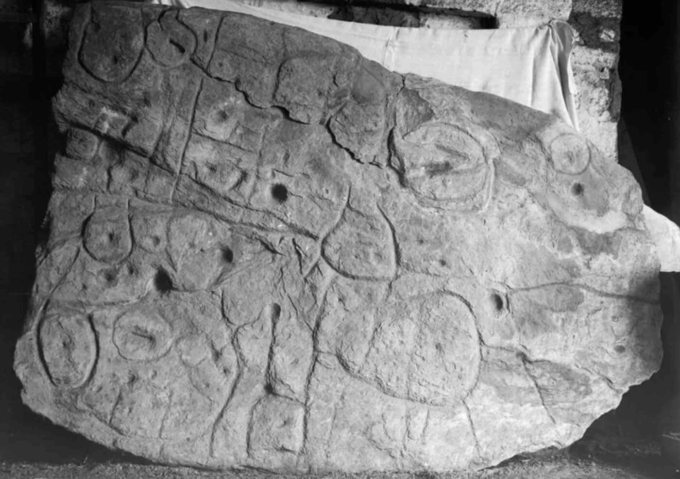
The Saint-Bélec slab, was first discovered in 1900, and thereafter largely forgotten for almost a century (public domain).
Recent Excavations and Fragment Discoveries
In a recent archaeological investigation at the original site of discovery, additional fragments of the Saint-Bélec slab were unearthed. These fragments, along with the main portion recovered in 1900, had been repurposed in the construction of a tomb wall. The ongoing research aims to provide a better understanding of the context in which the stone was found, offering valuable insights into the ancient landscape it represents.
While the Saint-Bélec slab is the oldest known map in Europe, similar ancient maps have been discovered worldwide. The Imago Mundi, or the Babylonian Map of the World, dating back to the 5th century BC, is considered one of the oldest maps globally and is currently housed at the British Museum in London.
The Saint-Bélec slab, once forgotten but now a focal point of archaeological research, has the potential to rewrite history by leading researchers to undiscovered ancient sites in Europe. As the decoding of its intricate markings continues, the stone stands as a testament to the enduring power of ancient cartography in unlocking the secrets of our past.