Archaeological evidence of ancient fences can reveal how people organized land, managed animals, and defined the boundaries of cultivated spaces. Although fences are often associated with visible wooden posts, stone walls, or surviving hedges, some boundary structures have been preserved beneath water or within waterlogged sediments. These remains may now lie under lakes, coastal waters, river deposits, or areas that became flooded long after the structures were abandoned. Their submerged condition can make them difficult to recognize, but it can also preserve materials that would normally decay in open air.
The term sunken fence can describe several different situations. A fence may have been built on dry land before rising water covered it, or a boundary may have been placed in a wet landscape that later experienced further flooding. Some structures may have been submerged by changes in sea level, while others became buried after rivers altered their courses or reservoirs were constructed. In certain locations, gradual land subsidence or the accumulation of sediment may have changed the relationship between a fence and the surrounding water. Understanding the process that led to submergence is essential because the present location of a structure does not necessarily reflect the environment in which it was originally used.
Agricultural boundaries served practical purposes in many societies. They could separate cultivated fields, protect crops from grazing animals, direct livestock between pastures, or mark areas controlled by particular households. Fences might also have been used to manage movement through shared landscapes, especially where seasonal farming and herding overlapped. However, a line of wooden posts discovered underwater cannot automatically be identified as an agricultural fence. Similar arrangements could have supported fish traps, defensive barriers, walkways, pens, or other structures. Archaeologists must examine the shape, construction, and surrounding evidence before determining its function.
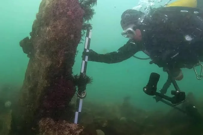
The physical arrangement of the remains can provide important clues. A series of posts aligned at regular intervals may indicate that a wooden fence once stood along a boundary. Horizontal timbers, woven branches, or traces of connecting materials could support that interpretation. If the posts form an enclosure around an area containing ancient field surfaces or evidence of livestock activity, the agricultural explanation becomes more plausible. In contrast, structures positioned across a tidal channel or beside a former watercourse may require investigation as possible fishing installations or water-management features. Their orientation and relationship to the local landscape can be as important as the surviving wood itself.
Waterlogged environments sometimes preserve wood because limited oxygen slows the activity of many organisms responsible for decomposition. Under favorable conditions, posts, branches, and even delicate construction details may survive for centuries or longer. This preservation is not guaranteed, however. Water chemistry, temperature, sediment composition, and the presence of microorganisms all affect the condition of buried timber. Wood may become soft and fragile even when its outer shape remains recognizable. If water levels change and the material is suddenly exposed to air, deterioration can accelerate, making careful excavation and conservation particularly important.
Dating a submerged fence requires researchers to distinguish between the age of the timber and the period when the structure was used. If the wood preserves a suitable sequence of annual growth rings, dendrochronology may establish when the tree was cut, provided the rings can be matched to an appropriate reference chronology. The presence of the outermost growth rings or bark edge can be especially useful because it may indicate that the timber was felled close to the time represented by its final ring. If the outer wood is missing, the date may be less precise, and the timber could have been reused after an earlier period of growth.
Radiocarbon dating offers another approach when suitable wood or other organic material is available. A sample can provide an estimated age range, but researchers must select the material carefully. Old wood may have been reused, stored, or incorporated into a later structure. Dating a piece of charcoal found near a fence may establish the age of an associated activity rather than the construction itself. Organic remains from sediment layers can also help establish environmental changes, but their relationship to the fence must be demonstrated rather than assumed.
An especially important distinction is the difference between construction, use, abandonment, and submergence. A fence could have been built during one period, repaired several times, and abandoned before rising water eventually covered it. These events may be separated by years, decades, or longer periods. The earliest date associated with the structure does not necessarily establish when it ceased to function, and the age of the sediment that covers it does not directly reveal when the fence was first built. Researchers therefore combine evidence from timber, surrounding deposits, repairs, and changes in the local environment to reconstruct the sequence of events.
Environmental archaeology can help explain why a formerly dry or cultivated area became submerged. Pollen preserved in sediment may reveal changes in vegetation, while plant remains and soil characteristics can provide evidence of past farming practices. Microscopic sediment layers may record flooding, erosion, or gradual changes in water levels. Where available, historical maps, geological studies, and records of regional sea-level change can provide additional context. These sources help researchers determine whether submergence occurred gradually or as a result of a more sudden event.
The interpretation of ancient boundaries also raises questions about land ownership and community organization. A fence separating two agricultural areas might have marked a household's fields, a shared grazing zone, or a boundary maintained by a wider community. Its construction could reflect practical concerns about crops and animals, but it may also have expressed social agreements about access to land. Such interpretations become stronger when the boundary can be connected to settlement remains, field systems, paths, storage areas, or evidence of repeated agricultural activity. The fence alone rarely reveals the exact social rules that governed the landscape.
Submerged agricultural boundaries are valuable because they preserve traces of how people modified and managed their environments. Their study requires close attention to construction methods, wood preservation, sediment formation, and the separate dates of building, use, abandonment, and flooding. When these lines of evidence are considered together, sunken fences can help reconstruct former landscapes and show how agricultural communities responded to changing environmental conditions. Even fragmentary posts and buried timbers can contribute to this understanding when their context is carefully documented and alternative explanations are tested.