The Roman road network was the "nervous system" of the ancient world. At its height, it spanned over 80,000 kilometers of paved highways and nearly 400,000 kilometers of secondary roads, stretching from the deserts of North Africa to the rainy borders of Hadrian’s Wall in Britain.
These roads were not just paths; they were masterpieces of multi-layered engineering designed to last for eternity (monumentum aere perennius).
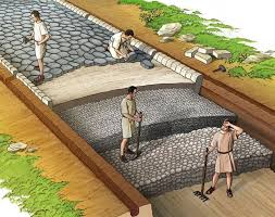
1. The Anatomy of a Roman Road
A Roman road was built like a deep foundation for a building. Engineers dug a trench (the fossa) down to the bedrock or solid ground and built upward in distinct layers.
Statumen: The first layer consisted of large, rough stones or "fist-sized" rocks to provide a solid base and drainage.
Rudus: A thick layer of smaller stones mixed with lime mortar or gravel was packed down on top of the base.
Nucleus: A layer of fine gravel, sand, or pounded lime was laid to provide a level bed for the final paving.
Pavimentum (Summum Dorsum): The top surface was made of large, flat polygonal slabs of basalt or hard volcanic stone, fitted together with incredible precision.
2. Engineering for Immortality: Drainage and Camber
The reason Roman roads still exist today is their sophisticated management of water, the greatest enemy of any pavement.
The Camber: Engineers built the center of the road slightly higher than the edges (a "crown"). This ensured that rainwater would flow off to the sides rather than pooling in the center.
Side Ditches: Parallel to the road, deep ditches (fossae) were dug to collect the runoff and carry it away from the structural layers, preventing the soil from becoming waterlogged and shifting.
Milestones: Every Roman mile (1,000 paces, or mille passus), a stone pillar was erected. These columns told travelers the distance to the next city and often credited the Emperor who paid for the road's construction.
3. The Groma: Achieving the "Roman Straight"
Roman roads are famous for being arrow-straight, even over rugged terrain. To achieve this, surveyors used a tool called a Groma.
The Tool: The Groma consisted of a vertical pole with a horizontal cross on top, from which four plumb lines hung. By sighting along these lines, surveyors could project a perfectly straight line across the landscape.
Navigation: They would use fire beacons or smoke signals to stay on course over long distances. While they preferred straight lines for speed and military efficiency, they were practical; if a hill was too steep, they would use "zig-zags" to maintain a manageable grade for wagons.
4. The Cursus Publicus: The Ancient Internet
The roads enabled the Cursus Publicus, the official state-run postal and courier service.
Mansiones: These were official "stopping stations" located every 25 to 30 miles (a day’s journey). They featured inns, stables, and granaries for government officials and soldiers.
Mutationes: Smaller stations located every 8 to 10 miles where couriers could quickly swap their tired horses for fresh ones.
Speed of Information: A courier could travel up to 80 kilometers (50 miles) a day. News of a rebellion or a new Emperor could travel from the frontier to Rome in a matter of weeks, an unprecedented speed for the era.
5. Tactical and Economic Dominance
While the roads eventually benefited merchants and travelers, their primary purpose was always military.
Rapid Deployment: The roads allowed the Roman Legions to march at a consistent pace of 30 kilometers a day, regardless of the weather. This meant Rome could strike faster than its enemies could mobilize.
Economic Integration: For the first time in history, heavy wagons could move goods (wine, olive oil, grain, and marble) across entire continents. This created a unified "global" economy where a merchant in Londinium could buy pottery made in North Africa.
6. The Legacy: "All Roads Lead to Rome"
The phrase was a literal reality. The Milliarium Aureum (Golden Milestone) was a monument in the Roman Forum that marked the starting point of all the Empire's major roads.
Even after the Western Empire fell, these roads remained the primary transport arteries of Europe for over a thousand years. In fact, many modern European motorways and English "A-roads" follow the exact footprints laid down by Roman engineers twenty centuries ago.