Introduction
Coastal cemeteries can provide important evidence about environmental change.
Gravestones, burial structures, and cemetery walls sometimes become submerged as sea levels rise or land surfaces sink. Their position beneath modern water can help researchers reconstruct changes in the relationship between human settlements and the coastline.
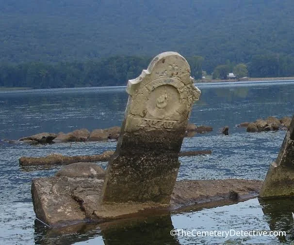
A submerged cemetery stone may also preserve physical indicators of former water levels. These include biological growth zones, mineral deposits, erosion patterns, and changes in surface texture.
However, interpreting these features requires careful scientific analysis. A submerged stone does not automatically provide an exact measurement of ancient sea level.
Cemeteries as Environmental Records
Cemeteries are often constructed in locations selected for religious, cultural, and practical reasons.
Coastal burial grounds may occupy low terraces, islands, estuaries, or shore-adjacent areas.
Over time, environmental changes can place these sites below modern sea level.
The survival of gravestones and burial structures creates a valuable archaeological record.
Their inscriptions may also provide historical dates that can be compared with geological evidence.
How Coastal Submergence Occurs
Several processes can cause a cemetery to become submerged.
Global sea-level rise occurs as ocean water expands and land-based ice melts.
Local relative sea-level change can also result from tectonic subsidence, sediment compaction, or changes in coastal landforms.
In some locations, earthquakes may produce sudden changes in land elevation.
Storms and erosion can remove protective sediment and expose previously buried structures.
The relative importance of each process varies between regions.
Physical Sea-level Indicators
Researchers examine several features on submerged stones.
Biological growth zones may indicate the depth at which organisms lived over extended periods.
Marine encrustations can reveal prolonged exposure to seawater.
Erosion patterns and mineral deposits may provide information about changing water conditions.
Certain marine organisms occupy relatively narrow vertical zones, making their remains useful as indicators of former sea level.
However, the relationship between biological growth and exact water height depends on local tides, wave action, salinity, and ecological conditions.
Gravestones and Historical Dating
Inscriptions can provide valuable chronological information.
A gravestone may identify the date of death or burial, allowing researchers to establish when the cemetery was in use.
If a dated stone is now submerged, it provides evidence that the surrounding ground was once above water or otherwise accessible for burial.
However, the date of the inscription is not necessarily the date of submergence.
The cemetery may have remained in use for decades or centuries after the earliest surviving marker was installed.
Distinguishing Sea-level Rise from Land Subsidence
One of the most important scientific challenges is separating changes in sea level from changes in land elevation.
A cemetery may become submerged because the ocean rose, because the land sank, or because both processes occurred.
Geologists use regional sea-level histories, sediment cores, geological structures, and historical records to investigate these possibilities.
Tectonic activity is particularly important in earthquake-prone coastal regions.
A single submerged grave cannot establish a regional sea-level trend without supporting environmental evidence.
Marine Encrustation and Preservation
Submerged gravestones may develop layers of algae, mollusks, barnacles, and other marine organisms.
These growths can obscure inscriptions and decorative details.
Mineral deposits may also form on the stone surface.
Different stone types respond differently to marine exposure.
Some materials are relatively resistant, while others may deteriorate through salt crystallization, biological activity, and chemical weathering.
Conservators must balance the need to document inscriptions with the importance of preserving the original surface.
Archaeological Survey Methods
Underwater survey can document submerged cemeteries without immediate excavation.
Divers may record inscriptions, dimensions, and the arrangement of stones.
Photogrammetry can produce three-dimensional models.
Sonar and bathymetric mapping can help locate larger cemetery areas and identify surrounding landscape features.
Sediment cores may reveal when marine deposits began accumulating over the burial ground.
Combining these methods can provide a more complete reconstruction of coastal change.
Cultural and Ethical Considerations
Submerged cemeteries are sensitive archaeological sites.
They contain human remains, personal names, religious symbols, and evidence of community memory.
Research should respect burial traditions and relevant legal protections.
Excavation should be undertaken only when scientifically justified and appropriately authorized.
In many cases, non-invasive documentation provides sufficient information while minimizing disturbance.
Conclusion
Submerged cemetery stones can provide important evidence for historical coastal change.
Their inscriptions, biological encrustations, mineral deposits, and relationship with surrounding sediments help researchers reconstruct how shorelines and land elevations changed over time.
However, interpreting these features requires distinguishing global sea-level rise from local subsidence and other geological processes.
When combined with historical records and environmental analysis, submerged cemeteries offer a powerful connection between human memory and the changing geography of coastal landscapes.