Introduction
Battlefields located near rivers, estuaries, and coastlines can leave archaeological traces beneath the water. Weapons, armor fragments, ammunition, personal belongings, ship components, and other objects may be lost during combat or discarded afterward. Over time, tides, currents, storms, and sediment movement can shift these materials far from their original locations.
Submerged battlefield archaeology must therefore address two connected questions: what happened at the site, and how did the artifacts move after the event?
An object recovered underwater may not remain where it was originally deposited. Its current position could reflect tidal transport, erosion, dredging, later construction, or other disturbances. Reconstructing a battlefield requires an understanding of both historical events and the processes that shaped the underwater archaeological record.
What Is Submerged Battlefield Debris?
Battlefield debris includes objects associated with armed conflict. In a marine or estuarine setting, this may include weapons, ammunition, fragments of vessels, personal equipment, and materials related to military transport.
Some objects may have entered the water during combat. Others may have been discarded during retreat, dumped during later cleanup, or lost through ordinary maritime activity.
The presence of a weapon underwater does not automatically identify a battlefield. It may have come from a shipwreck, a training area, a later disposal event, or an unrelated accident.
A secure interpretation requires a combination of artifact analysis, historical research, spatial patterns, and environmental evidence.
How Tides Move Artifacts
Tides produce changing water levels and currents. Their strength and direction vary with coastal geography, water depth, weather, and the shape of the seabed.
Objects may be moved when currents are strong enough to overcome the forces holding them in place. Movement depends on an artifact's weight, shape, density, and interaction with sediment.
Small or lightweight objects may be transported more readily than large, heavy items. Yet even heavy objects can move during powerful storms, especially when the seabed is disturbed.
The movement is not always continuous. An artifact may shift during one storm, become buried, and remain stable for decades before being exposed again.
Sediment and Burial
Sediment plays a major role in the preservation of submerged artifacts.
Sand, silt, and mud can cover objects, protecting them from some forms of physical disturbance. Burial may also create conditions that slow corrosion for certain materials, although preservation depends on oxygen, chemistry, and other factors.
When currents remove sediment, previously buried artifacts may become exposed.
An exposed object can then be moved, damaged, or lost. Repeated cycles of burial and exposure may create a complex archaeological distribution.
Researchers must therefore distinguish between the original location of an object and the place where it was eventually recovered.
Identifying a Battlefield Through Artifact Patterns
The distribution of artifacts can help researchers identify areas associated with conflict.
A concentration of projectiles, weapons, military equipment, and personal belongings may suggest a battlefield or military activity zone.
The arrangement matters. Artifacts distributed along a narrow channel may have been transported by currents, while a more localized concentration could reflect an original deposit.
However, spatial patterns are rarely self-explanatory. A cluster may result from a shipwreck, a later dumping event, or a natural sediment trap.
Researchers use seabed mapping, artifact recording, sediment analysis, and historical accounts to evaluate competing explanations.
Historical Research
Historical records can provide information about battles, ship movements, military positions, and coastal geography.
Maps may identify former shorelines, channels, forts, landing places, or defensive barriers. Written accounts may describe the loss of vessels or equipment.
Yet historical descriptions are not always precise, and maps may simplify underwater terrain.
Researchers must compare historical evidence with archaeological findings rather than treating a written account as proof that a particular artifact belongs to the event.
Changes in coastlines and navigation channels can also mean that a modern map does not accurately represent the battlefield's original setting.
Dating Battlefield Debris
Dating artifacts can help establish whether they are consistent with a known conflict.
Weapon designs, manufacturing marks, inscriptions, and associated objects may provide chronological clues.
Scientific dating may be possible for suitable organic materials, although the material must be securely associated with the event.
A modern or later object found among older debris may reflect disturbance or continued use of the area.
Chronology should therefore be established for the assemblage as a whole, with particular attention to objects that may have been introduced after the original event.
Distinguishing Combat Losses from Later Disposal
Battlefields can be cleaned after combat. Weapons may be collected, damaged equipment salvaged, and bodies or debris removed.
As a result, the surviving archaeological assemblage may represent only a small portion of what was originally present.
Some objects might have entered the water during later salvage operations or disposal activities.
Archaeologists investigate these possibilities through the condition of artifacts, the distribution of remains, and documentary evidence about post-battle activities.
A battlefield's archaeological record is therefore not a complete inventory of the battle. It is the surviving product of combat, recovery, erosion, and later human activity.
Underwater Survey Techniques
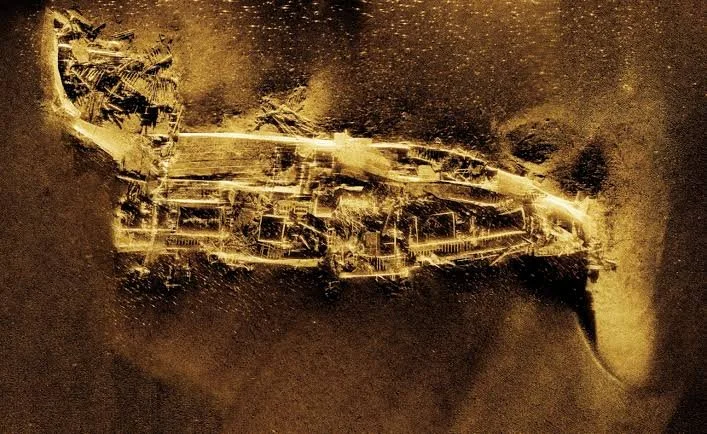
Submerged battlefield investigations may use side-scan sonar, multibeam bathymetry, magnetometry, remotely operated vehicles, and diver surveys.
Sonar can identify objects and changes in seabed topography. Magnetometry can detect some ferrous materials, while visual inspection provides detailed information about exposed remains.
Photogrammetry can produce three-dimensional records of objects and wreck sites.
Each method has limitations. Some materials are difficult to detect, sediment may conceal artifacts, and environmental conditions may restrict access.
A systematic survey is necessary to reduce the risk of recovering only the most visible or accessible objects.
Conservation of Underwater Artifacts
Objects recovered from underwater environments can deteriorate rapidly after exposure to air.
Metal artifacts may contain salts and corrosion products that become unstable during drying. Organic materials can also be damaged if their moisture conditions change suddenly.
Conservation specialists must assess the material and its condition before deciding how to recover, transport, store, or treat it.
In some cases, leaving an object in place and documenting it may be preferable to removal.
The conservation strategy should balance research value, long-term preservation, legal obligations, and the site's wider archaeological significance.
Ethical and Legal Considerations
Submerged battlefields may contain human remains, military graves, or culturally sensitive objects. Some sites may be protected under heritage or maritime laws.
Researchers should consult relevant authorities and follow established procedures before conducting intrusive work.
Artifacts should not be removed simply because they are accessible. Their location and association with other objects may provide more information than the object alone.
Responsible battlefield archaeology prioritizes documentation, preservation, and the respectful treatment of human remains.
Conclusion
Submerged battlefield debris can reveal important information about conflict, military equipment, and maritime history. Yet tides, currents, sediment movement, storms, and later human activity can redistribute artifacts, making their original locations difficult to reconstruct.
A weapon recovered underwater does not automatically prove the presence of a battlefield. Reliable interpretation depends on artifact analysis, spatial mapping, historical research, dating, and an understanding of local hydrodynamics.
By studying how objects entered the water and how they moved afterward, archaeologists can reconstruct not only the events of conflict but also the environmental processes that shaped the surviving evidence. The seabed becomes a historical landscape whose contents must be interpreted through both human history and natural change.