The Vikings were legendary for their ability to navigate the open ocean, traveling from Scandinavia to Greenland and North America. However, the North Atlantic posed a unique problem: the "midnight sun" of summer and the frequent fog meant that stars were often invisible. To solve this, the Norse relied on a sophisticated understanding of solar geometry and a specialized tool known as the Sun Compass.
1. The Uunartoq Discovery
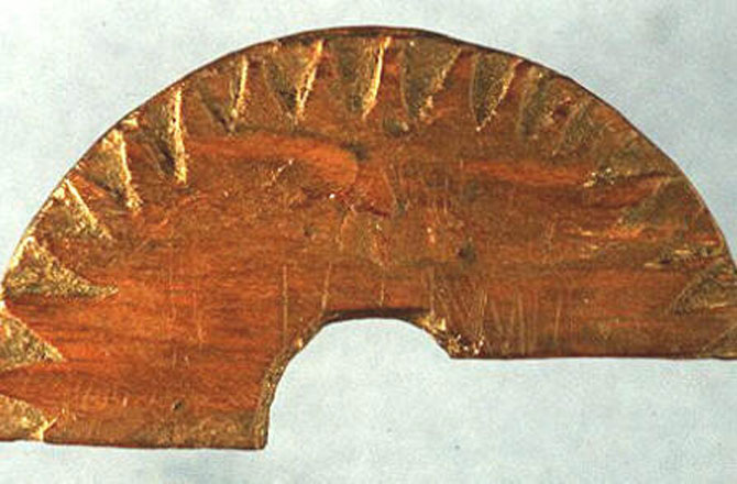
For decades, historians wondered how Vikings maintained a straight course across thousands of miles of open water. In 1948, a fragment of a wooden disc was discovered in an 11th-century Norse nunnery at Uunartoq, Greenland.
Initially thought to be a decorative object, researchers eventually realized it was a navigational instrument. The artifact featured a central hole for a vertical pin (a gnomon) and a series of curved lines etched into the wood.
2. How the Compass Worked
The Viking Sun Compass was not a magnetic device; it was a solar shadow tracker.
The Gnomon: A small vertical pin was placed in the center of the disc. As the sun moved across the sky, the pin cast a shadow onto the wooden plate.
The Gnomonic Curve: Before a voyage, a navigator would track the shadow of the sun throughout a full day on land, marking the tip of the shadow at various intervals. This created a hyperbola—the "gnomonic curve."
Staying on Course: During the voyage, the navigator would rotate the disc until the tip of the current shadow touched the pre-drawn curve. Once aligned, the disc pointed exactly North-South, allowing the captain to determine his heading with an accuracy of within 5 degrees.
3. Latitude Sailing
The Vikings utilized a technique called "latitude sailing." If they knew their destination (like Greenland) was at a specific latitude, they would sail North or South until they hit that "line," then use the Sun Compass to keep their shadow tip on the correct curve as they sailed West. As long as the shadow stayed on that specific line, they knew they were staying on the correct latitude.
4. The Mystery of the Sunstone
The greatest challenge to a sun compass is a cloudy day. However, the Norse sagas and archaeological evidence suggest they had a "high-tech" solution for this: the Sunstone (sólarsteinn).
Polarization: Researchers believe these stones were crystals of Iceland Spar (calcite). This mineral has a property called "double refraction."
Locating the Sun: Even when the sun is behind thick clouds or just below the horizon, it polarizes the atmosphere. By holding the crystal up and rotating it, a navigator can see two images of the sky. When the two images reach equal brightness, the crystal is pointing directly at the sun.
The Combo: By using the Sunstone to find the sun’s position and then using that position to cast a shadow on the Sun Compass, the Vikings could navigate in conditions that would leave other ancient sailors blind.
5. The "Horizon Board" Supplement
In addition to the compass, Vikings often used a "Horizon Board." This was a simple wooden board with a slit held at arm’s length. By aligning the bottom with the horizon and the top with the sun at noon, they could measure the sun's height. If the sun was higher than it should be, they were too far South; if it was lower, they were too far North.
6. Modern Testing and Accuracy
In recent years, maritime archaeologists have built replicas of the Uunartoq disc and tested them on the North Atlantic. They found that even with the rocking of a ship, the compass is remarkably stable and accurate.
The success of the Sun Compass proves that Viking navigation was not based on luck or "instinct," but on a profound, practical application of spherical astronomy and geometry that was centuries ahead of its time.