• MAIN PAGE
  • LATEST NEWS
    • Lost Cities
    • Archaeology's Greatest Finds
    • Underwater Discoveries
    • Greatest Inventions
    • Studies
    • Blog
  • PHILOSOPHY
  • HISTORY
  • RELIGIONS
    • Africa
    • Anatolia
    • Arabian Peninsula
    • Balkan Region
    • China - East Asia
    • Europe
    • Eurasian Steppe
    • Levant
    • Mesopotamia
    • Oceania - SE Asia
    • Pre-Columbian Civilizations of America
    • Iranian Plateau - Central Asia
    • Indus Valley - South Asia
    • Japan
    • The Archaeologist Editor Group
    • Scientific Studies
    • Aegean Prehistory
    • Historical Period
    • Byzantine Middle Ages
    • Predynastic Period
    • Dynastic Period
    • Greco-Roman Egypt
  • Rome
  • PALEONTOLOGY
  • About us
Menu

The Archaeologist

  • MAIN PAGE
  • LATEST NEWS
  • DISCOVERIES
    • Lost Cities
    • Archaeology's Greatest Finds
    • Underwater Discoveries
    • Greatest Inventions
    • Studies
    • Blog
  • PHILOSOPHY
  • HISTORY
  • RELIGIONS
  • World Civilizations
    • Africa
    • Anatolia
    • Arabian Peninsula
    • Balkan Region
    • China - East Asia
    • Europe
    • Eurasian Steppe
    • Levant
    • Mesopotamia
    • Oceania - SE Asia
    • Pre-Columbian Civilizations of America
    • Iranian Plateau - Central Asia
    • Indus Valley - South Asia
    • Japan
    • The Archaeologist Editor Group
    • Scientific Studies
  • GREECE
    • Aegean Prehistory
    • Historical Period
    • Byzantine Middle Ages
  • Egypt
    • Predynastic Period
    • Dynastic Period
    • Greco-Roman Egypt
  • Rome
  • PALEONTOLOGY
  • About us

Why the North Pole looked like this on Old Maps

February 26, 2024

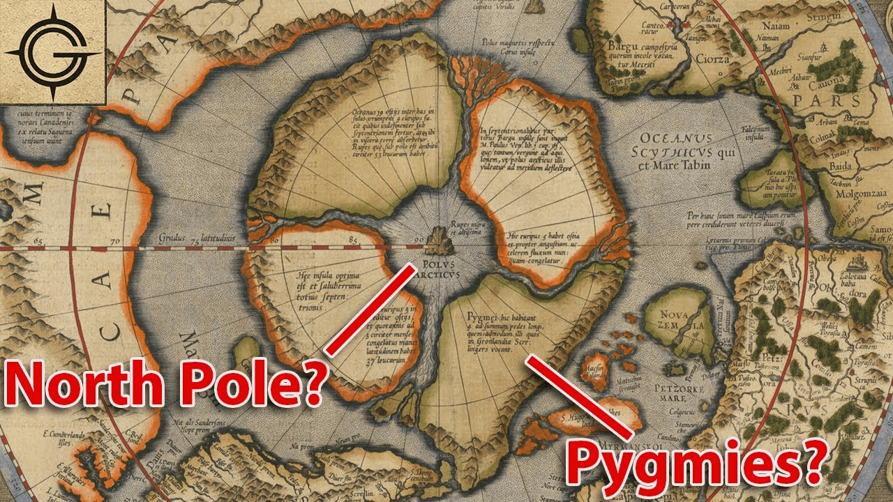
The Arctic has always been a region of fascination and mystery, and this 16th-century map adds another layer to its enigmatic allure. The depiction of four major land masses surrounding a polar sea, with a massive magnetic rock at its center known as Rupes Nigra, or the Black Rock, is both captivating and mysterious.

Maps from this era often combined cartographic knowledge with elements of folklore, mythology, and speculation, leading to the inclusion of fantastical elements such as mythical creatures, unexplored lands, and, apparently, magnetic anomalies like the Black Rock.

The mention of a massive magnetic rock hints at the early understanding of magnetic forces and their influence on navigation, a critical aspect of exploration during the Age of Discovery. The presence of such a landmark on the map underscores the challenges and dangers faced by explorers navigating the treacherous Arctic waters.

As we unravel the mysteries of this ancient map, we are reminded of the enduring human fascination with the unknown and the relentless quest for knowledge that drives exploration. It serves as a testament to the ingenuity and curiosity of early cartographers who sought to chart the uncharted and unlock the secrets of the world.

← 10 Most Wanted Lost Objects In The Whole World!This is Why the Columns of the Palace of Knossos Were Made of Wood →
Featured
Gemini_Generated_Image_pd1afspd1afspd1a.png
Jul 24, 2025
The Myth of the Yeti: Ancient Legends of the Himalayas
Jul 24, 2025
Read More →
Jul 24, 2025
Gemini_Generated_Image_cn4p9gcn4p9gcn4p.png
Jul 24, 2025
The Worship of Baal in the Ancient Levant
Jul 24, 2025
Read More →
Jul 24, 2025
Gemini_Generated_Image_o3almto3almto3al.png
Jul 24, 2025
The Role of the Oracle of Delphi in Greek Society
Jul 24, 2025
Read More →
Jul 24, 2025
07h_cotoca_screenshot_8_web.webp
Jul 24, 2025
The Lost Cities of the Amazon: Fact or Fiction?
Jul 24, 2025
Read More →
Jul 24, 2025
alphabet1.jpg
Jul 24, 2025
The Origins of the Alphabet: From Phoenicia to the World
Jul 24, 2025
Read More →
Jul 24, 2025
Gemini_Generated_Image_cmp6nocmp6nocmp6.png
Jul 24, 2025
The Worship of Kukulkan, the Feathered Serpent of the Maya
Jul 24, 2025
Read More →
Jul 24, 2025
read more

Powered by The archaeologist