Introduction
Large dams transform landscapes. They create reservoirs, alter river systems, affect roads and settlements, and can permanently cover places where people once lived and worked. In Lesotho, the construction of major water infrastructure has played an important role in regional development and water management. It has also raised questions about the archaeological and social heritage of areas affected by reservoir creation.
The title Katse Dam Relics: Lesotho's Submerged Villages focuses on the heritage associated with the Katse Dam and the possibility that earlier settlement remains were affected by the formation of its reservoir. The exact number, location, and character of any submerged villages must be established through historical and environmental records rather than assumed from the existence of the dam alone.
Even where buildings are not physically submerged, the creation of a reservoir can change access to land, routes, grazing areas, and places of cultural importance. Understanding these changes requires attention to both archaeological remains and the experiences of affected communities.
The Lesotho Highlands Water Project
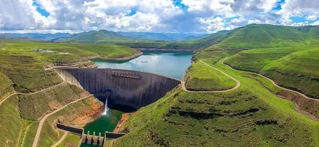
Katse Dam is a major component of the Lesotho Highlands Water Project, a large infrastructure initiative designed to transfer water from Lesotho's highlands to South Africa while also providing associated benefits within Lesotho.
The project required extensive engineering, including dam construction, tunnels, roads, and related facilities. These developments changed parts of the highland landscape and created a large reservoir behind the dam.
The project has significant economic and strategic importance because Lesotho's mountainous environment collects water that contributes to regional river systems. At the same time, major infrastructure projects can have substantial local consequences, especially when land is acquired, settlements are relocated, or access to resources changes.
A balanced history of Katse Dam should therefore examine both its engineering achievements and the social and environmental changes associated with its development.
What Happens When a Reservoir Is Created?
When a reservoir fills, water covers the lower parts of the landscape behind a dam. The affected area may include riverbanks, fields, paths, buildings, archaeological sites, and places used for grazing or gathering natural resources.
Not all affected places are necessarily villages, and not every structure becomes permanently submerged. Some areas may be flooded only under particular water levels, while others remain above the reservoir.
Before construction, environmental and heritage assessments may identify archaeological sites and places of cultural significance. Where remains are at risk, surveys or excavations can sometimes document them before flooding occurs.
However, the quality and completeness of this record depend on the scope of the investigations, the time available, the resources provided, and the accessibility of the landscape. Some archaeological information may remain incomplete even after a formal assessment.
Archaeology Before Flooding
Archaeological work associated with dam construction is often described as rescue or salvage archaeology. Its purpose is to record evidence that might otherwise be destroyed or made inaccessible by development.
Researchers may survey the area, map settlement remains, collect surface artefacts, and excavate selected locations. They may document stone foundations, livestock enclosures, pottery, tools, burials, or other evidence of past activity where present and appropriate to investigate.
The archaeological record can help establish how people used the landscape before the reservoir was created. It may reveal settlement patterns, household economies, farming practices, livestock management, and connections between communities.
Yet salvage archaeology has limitations. It often operates under strict deadlines and may focus on sites considered most likely to be affected. The resulting record may not represent every settlement or every aspect of local history.
The Human Meaning of Submerged Landscapes
A village is not simply a group of buildings. It is a place connected to family histories, daily routines, community relationships, and memories. Fields may be associated with generations of work, while paths connect households to relatives, schools, religious institutions, and markets.
When a reservoir changes the landscape, the effects may continue long after construction is completed. People may need to relocate, change their livelihoods, or travel different routes to reach familiar places. Compensation and resettlement arrangements can influence how households adapt, but they do not necessarily replace the social and cultural value of the places affected.
These experiences should not be reduced to the idea that a village has simply disappeared beneath water. Communities may continue elsewhere, maintaining relationships and memories while adapting to new circumstances.
Oral histories can preserve details that official project records may not fully capture. They may describe former settlement locations, land use, local place names, and the ways people experienced relocation. Such accounts should be collected respectfully and with the consent of participants.
Distinguishing Archaeological Relics from Modern Ruins
The word “relics” can refer to surviving objects, structures, or traces of an earlier way of life. At Katse, any claim about submerged archaeological remains must be supported by reliable evidence.
Researchers might use historical maps, aerial photographs, engineering records, heritage surveys, and oral accounts to identify former settlement locations. Where water levels permit, some exposed areas may be examined, but underwater archaeological investigation requires specialized methods and safety procedures.
A structure visible near a reservoir's edge may not necessarily be ancient. It could belong to a relatively recent settlement or infrastructure project. Similarly, an object recovered from reservoir sediment may have been transported by water rather than remaining at its original location.
Dating and contextual evidence are therefore essential before a site can be described as prehistoric, Iron Age, or associated with a particular historical community.
Environmental Change and Archaeological Preservation
Reservoirs alter local water levels, sediment movement, and shoreline conditions. These changes can affect archaeological deposits in different ways.
Permanent submersion may reduce exposure to some forms of weathering, but it does not guarantee preservation. Water movement, changing oxygen conditions, erosion, and chemical processes can damage structures and artefacts. Shoreline fluctuations can also expose remains to repeated cycles of wetting, drying, and physical disturbance.
The best conservation strategy is often to document vulnerable sites before they are affected and to monitor important remains where practical.
Lessons for Future Infrastructure
The experience of large dam projects demonstrates why heritage planning should begin early. Archaeological surveys, community consultation, historical documentation, and resettlement planning should be integrated into project development rather than treated as secondary concerns.
Communities should have meaningful opportunities to identify places that matter to them and to contribute to decisions about documentation, access, and preservation. Museum collections and archives can help keep records accessible, while community-led projects can preserve memories of transformed landscapes.
Conclusion
Katse Dam's heritage provides an important opportunity to examine the relationship between infrastructure, archaeological preservation, and community displacement in Lesotho. The specific history of any submerged village or archaeological site must be established through reliable records, but the broader issues are clear: reservoirs can permanently transform landscapes that contain generations of human history.
Understanding this transformation requires more than identifying objects beneath the water. It means documenting former settlements, preserving archaeological evidence, listening to affected communities, and recognizing that the loss of a familiar landscape can involve social and cultural changes as well as physical ones.