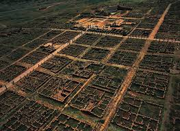
Timgad (ancient Thamugadi) is widely considered the most "perfect" example of Roman grid planning in existence. Founded by Emperor Trajan around 100 CE as a colony for retired veterans of the 3rd Augustan Legion, it was built ex nihilo—from scratch—on a pristine site in what is now Algeria.
Because the city was never built over by later medieval or modern settlements (it was largely preserved by encroaching sand until its excavation in 1881), it provides an unparalleled "fossilized" view of the Roman urban ideal.
The Orthogonal Blueprint
Timgad’s layout is a physical manifestation of the Roman castrum (military camp). The city is contained within a near-perfect square, originally divided into 111 precise, equal blocks (insulae). This strict adherence to geometry served both a practical purpose—efficient allocation of land for veterans—and a symbolic one, broadcasting Roman order and authority into the rugged North African landscape.
The Intersecting Axes
The heart of the grid is defined by the intersection of two primary roads:
The Cardo Maximus: The primary north-south axis.
The Decumanus Maximus: The primary east-west axis.
In typical Roman planning, these two roads formed the "cross" of the city. At the point where they met—the groma (the central intersection)—stood the town center. In Timgad, this junction is marked by a grand triumphal arch (the Arch of Trajan), which served as both an ornamental gate and the symbolic centerpiece of the city.
Spatial Organization
The grid system at Timgad was not merely decorative; it dictated the social and functional hierarchy of the city:
The Civic Core: At the central intersection of the cardo and decumanus were the public institutions: the Forum (the market and administrative heart), the Basilica (legal and business center), the Curia (senate house), and a public library. This placement ensured that every citizen had easy, central access to the core functions of Roman life.
Modular Living: The residential blocks were consistent in size, demonstrating the Romans' preference for standardized urban development. While later growth caused the city to spill beyond its original walls—leading to the construction of extra temples, baths, and theaters in the 2nd century—the central 111-block grid remained the city's backbone.
Infrastructure Integration: Beneath the meticulously paved limestone streets ran a sophisticated network of sewers and water lines. The street grid also dictated the flow of public amenities; for instance, the city featured over a dozen public bathhouses, strategically integrated into the residential blocks to ensure every veteran enjoyed the comforts of the capital.
Why Timgad is Unique
Timgad illustrates that Roman urban planning was essentially an exportable technology. By applying a rigid, "chess-board" plan to a frontier province, the Romans were able to rapidly turn a remote military outpost into a sophisticated civilian city that looked and functioned exactly like a miniature Rome.
The city’s preservation under the Saharan sands provides an "archaeological x-ray" of the Roman mind: an obsession with order, symmetry, and the belief that environment could be mastered through engineering and architecture.