Introduction
Salt was one of the most important resources in many pre-industrial societies. It was essential for food preservation, animal husbandry, household consumption, and numerous manufacturing activities.
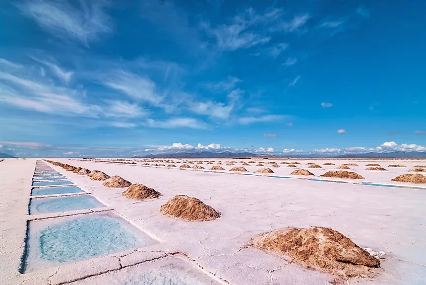
Coastal communities developed different methods of producing salt from seawater. In suitable environments, shallow evaporation ponds, channels, embankments, and saltpans could be constructed to control the movement of water and encourage crystallization.
These installations were not simply technical features. They could also define areas of ownership, access, taxation, and customary rights. The boundaries of a saltpan might therefore have carried legal and economic significance within a coastal community.
The archaeology of saltpan boundaries offers an opportunity to understand how resource management, landscape modification, and local law were connected.
Understanding Saltpans
Saltpans are shallow constructed areas used to produce salt through evaporation.
In many coastal settings, seawater is directed through channels into a series of ponds. As water evaporates, the concentration of salt increases until crystals can be collected.
The design of a saltpan depends on local conditions, including temperature, rainfall, tidal patterns, soil composition, and access to seawater.
Some systems were relatively simple, while others involved extensive networks of channels, embankments, and evaporation basins.
Why Boundaries Were Important
Salt production required control over land and water.
A saltpan operator needed access to a suitable coastal area, a reliable water supply, and the infrastructure required to manage evaporation.
Boundaries could identify which family, household, cooperative, institution, or authority controlled a particular production area.
They could also separate working areas from neighboring properties and establish access routes for workers, carts, animals, and maintenance activities.
In communities where salt was valuable, clearly recognized boundaries could reduce disputes and protect production rights.
Physical Boundary Features
Saltpan boundaries might consist of earthen embankments, stone walls, ditches, channels, or raised paths.
These features could serve practical functions by controlling water movement and preventing unwanted flooding.
At the same time, their layout could establish recognizable divisions between different production units.
A boundary might therefore have both an engineering function and a legal or customary meaning.
However, not every embankment represents a property line. Some were constructed primarily to regulate water levels.
Salt Production and Local Law
Salt production could be subject to different forms of regulation.
Authorities might collect taxes, grant production rights, regulate prices, or control access to salt resources.
Local communities could also maintain customary rules governing the use of shared coastal areas.
In some places, rights may have been inherited or transferred through family arrangements.
In others, production areas could be leased or operated under the authority of a government or institution.
These arrangements varied across regions and historical periods.
Shared Resources and Disputes
Saltpans often depended on interconnected systems of water channels.
A change to one channel could affect neighboring production areas.
If one operator diverted water, blocked a passage, or damaged an embankment, other producers might experience reduced output.
Boundaries could therefore help define responsibilities for maintenance and establish which users were entitled to access particular sections of the system.
Disputes might concern water supply, labor obligations, property ownership, taxation, or the movement of livestock and equipment.
Archaeological Identification
Archaeologists identify salt production through a combination of landscape features and material evidence.
They may examine evaporation basins, channels, embankments, working surfaces, storage areas, and concentrations of salt-related deposits.
Sediment analysis can help identify areas repeatedly exposed to saline water.
Historical maps and property records may provide information about the division of production areas.
The relationship between physical boundaries and documentary evidence is especially important when investigating legal ownership.
Saltpan Boundaries as Historical Landscapes
Saltpan systems could remain in use for generations.
Their boundaries might be repaired, extended, or modified as production methods changed.
A single landscape could therefore contain several phases of construction.
Older channels might be abandoned, while newer embankments altered the direction of water movement.
Archaeological survey can reveal these changes and help reconstruct how coastal communities reorganized their production areas over time.
Environmental Change and Boundary Movement
Coastal landscapes are dynamic.
Sea-level change, storms, erosion, sediment accumulation, and shifting shorelines can alter saltpan systems.
An area once suitable for salt production may become submerged or disconnected from seawater.
In other locations, sediment accumulation may create new land that can be incorporated into production.
These environmental changes could also affect property boundaries and customary rights.
A legal boundary recorded in an old document may no longer correspond to a visible feature in the modern landscape.
Documentary and Oral Evidence
Written records can be particularly valuable for reconstructing saltpan ownership.
Property deeds, tax registers, court cases, maps, leases, and administrative documents may identify production rights and boundary disputes.
Oral histories can preserve information about traditional ownership and the names of particular salt-producing areas.
These sources should be compared with archaeological evidence because legal descriptions may use landmarks that have disappeared or changed.
Conclusion
Saltpan boundaries were potentially important markers of property, access, and responsibility in coastal communities. Their physical form could regulate water and protect production, while their social meaning could establish who was entitled to use particular areas.
Understanding these boundaries requires combining archaeological survey with historical documents, environmental reconstruction, and local knowledge.
The study of saltpans demonstrates that industrial landscapes were also social and legal landscapes. Even a shallow evaporation pond could reflect complex relationships involving ownership, taxation, cooperation, and control over valuable natural resources.