Introduction
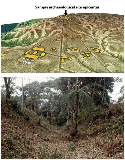
Located on the eastern slopes of the Andes Mountains in central Ecuador, Sangay National Park contains one of the most remarkable archaeological landscapes ever discovered in the upper Amazon. In 2024, extensive LiDAR (Light Detection and Ranging) surveys revealed an enormous network of ancient settlements hidden beneath dense tropical forests in the Upano Valley, dramatically changing archaeologists' understanding of early Amazonian civilizations. Although the region had long been known for scattered archaeological sites, the airborne laser mapping exposed an interconnected urban landscape dating from approximately 500 BCE to 600 CE, making it one of the oldest and largest known prehistoric settlement systems in the western Amazon. The discoveries demonstrated that complex societies flourished in Ecuador's rainforest centuries before the rise of the Inca Empire, challenging the traditional belief that the Amazon supported only small, isolated villages.
The Upano Valley Road Network
The LiDAR surveys uncovered an extraordinary system of broad, straight roads extending for dozens of kilometers across the Upano Valley. These roads connected hundreds of settlements, ceremonial centers, agricultural fields, and public plazas into a highly organized regional network. Many of the roads measured 10 to 20 meters wide, with some extending more than 25 kilometers, making them among the most sophisticated transportation systems known in pre-Columbian Amazonia.
Unlike simple forest paths, these roads were carefully engineered with raised earthen embankments that enabled travel during seasonal rains and flooding. Their remarkably straight alignments suggest deliberate planning rather than gradual expansion, indicating that construction was coordinated by organized communities capable of mobilizing large labor forces. Smaller feeder roads branched from the major routes, linking residential neighborhoods with agricultural terraces and ceremonial complexes, thereby facilitating trade, communication, and political administration across the region.
Urban Planning and Agricultural Engineering
LiDAR mapping also revealed that the Upano Valley contained hundreds of planned settlements arranged according to standardized layouts. Residential compounds were constructed on raised earthen platforms connected by roadways, while large rectangular plazas served as communal gathering places for ceremonies, trade, and political activities. Archaeologists identified clusters of settlements organized around larger administrative centers, suggesting the existence of hierarchical communities rather than isolated villages.
The inhabitants also demonstrated remarkable skill in environmental engineering. Extensive agricultural fields, drainage canals, terraces, and irrigation systems were carefully integrated into the landscape to maximize food production despite heavy rainfall. These hydraulic systems controlled excess water, reduced soil erosion, and improved crop cultivation, allowing relatively large populations to thrive within the tropical rainforest. Rather than destroying the forest, the inhabitants managed their environment sustainably while maintaining productive farmland and transportation networks.
Significance of the Discovery
The Upano Valley discoveries rank among the most important archaeological breakthroughs in South America. The extensive road systems, planned settlements, and sophisticated landscape engineering reveal that the upper Amazon supported dense, organized populations with advanced knowledge of construction, agriculture, and regional planning. These findings challenge long-standing assumptions that tropical rainforests prevented the development of large urban societies. Instead, the evidence suggests that Indigenous communities created sustainable cities that coexisted with the surrounding environment for centuries.
The discoveries also provide valuable insight into the diversity of pre-Columbian civilizations throughout Amazonia. Together with recent LiDAR findings from Brazil, Bolivia, and Colombia, the Upano Valley demonstrates that complex societies developed independently across multiple regions of the Amazon Basin, each adapting engineering techniques to their unique landscapes while maintaining extensive trade and communication networks.
Conclusion
The archaeological discoveries within Sangay National Park's Upano Valley have fundamentally transformed our understanding of ancient Amazonian civilization. The identification of extensive road networks, planned settlements, ceremonial plazas, and advanced agricultural infrastructure confirms that the region supported highly organized societies long before European contact. These remarkable engineering achievements reveal the ingenuity of Ecuador's early inhabitants and demonstrate that the Amazon rainforest was home to sophisticated urban landscapes whose complexity rivals many of the great civilizations of the ancient world.