Introduction
The North Atlantic islands contain a rich archaeological record of prehistoric movement, settlement, and interaction. During the Bronze Age, communities across parts of northwestern Europe developed varied relationships with the sea, using boats to travel between islands, exploit marine resources, and maintain connections with neighboring populations.
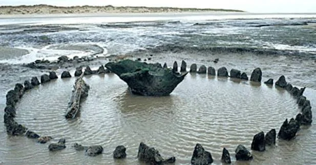
The possibility of submerged causeways introduces an important question: how did ancient people connect areas of land that are now separated by water or altered coastlines? A causeway is a constructed route across wet ground, tidal flats, shallow water, or another difficult landscape. Some causeways may survive underwater because sea levels rose, land subsided, or coastal processes changed the environment.
However, a submerged stone alignment or raised feature does not automatically represent a Bronze Age causeway. Natural geology, later construction, and changes in sediment movement can create similar patterns. Establishing the age and function of a suspected causeway requires careful underwater survey, geological analysis, and archaeological dating.
The North Atlantic as a Connected Landscape
The North Atlantic was not necessarily a barrier to prehistoric communities. Islands, coastal promontories, sheltered bays, and maritime routes could connect people who lived across substantial distances.
Communities used boats and other forms of water transport long before the Bronze Age, although the specific vessels and sailing practices varied across time and region.
The sea also shaped settlement patterns. Access to fish, shellfish, marine mammals, seabirds, and coastal plants could support communities whose economies combined land-based and marine resources.
Understanding submerged causeways requires this wider context. A constructed route may have connected two areas of a single island, linked a settlement with a tidal resource zone, or provided access across wet ground near a harbor.
What Is a Causeway?
A causeway is a raised or constructed route designed to make movement easier across terrain that would otherwise be difficult to cross.
It may consist of stone, earth, timber, or combinations of materials. Some causeways cross wetlands, while others extend through tidal areas or shallow water.
The design depends on local conditions. A route across a marsh may require a different structure from one built across a rocky intertidal zone.
Causeways may also have served several functions. A raised route could facilitate everyday movement, connect settlements, provide access to ritual places, or support the movement of livestock and goods.
Archaeologists must establish the relationship between a structure and its landscape before assigning a particular function.
Why Causeways Become Submerged
Several processes can place a former causeway underwater.
Relative sea-level rise can inundate low-lying land. Local tectonic movement can alter the elevation of the coast, while erosion may remove the sediment that once supported a route.
In some regions, postglacial land movement has produced complex changes in relative sea level. Land can rise after the removal of massive ice sheets, while other areas may experience different combinations of uplift and sea-level rise.
Coastal sedimentation can also alter how a causeway appears. A route may become buried beneath sand or mud before later erosion exposes it.
The local geological history is therefore essential for determining why a suspected causeway is submerged.
Identifying Submerged Structures
Underwater archaeological surveys can use sonar, bathymetric mapping, photogrammetry, and direct inspection.
These techniques may reveal linear stone arrangements, raised seabed features, or repeated structural patterns.
Researchers examine whether the feature follows a practical route between two landforms and whether its construction differs from the surrounding geology.
A naturally occurring rock ridge may resemble a built causeway. Similarly, glacial deposits or later stonework can produce artificial-looking alignments.
The strongest interpretations rely on evidence of construction, such as arranged stones, repeated structural dimensions, or a clear relationship with associated archaeological features.
Dating a Possible Bronze Age Causeway
Establishing a Bronze Age date requires more than observing that a feature lies underwater.
Potential evidence may include securely associated artifacts, datable organic material, construction deposits, or environmental layers that establish when the route was built or used.
Radiocarbon dating may be possible when suitable organic material survives in a secure context. Other dating techniques may help establish the age of surrounding sediments.
The dating of the structure itself must be distinguished from the date when it became submerged. A route may have been used for centuries before changes in sea level or erosion altered its setting.
If no direct dating evidence exists, the feature should be described as a possible prehistoric structure rather than a confirmed Bronze Age causeway.
Everyday Movement and Economic Activity
If a causeway was used during the Bronze Age, it could have supported practical activities such as moving between settlement areas, accessing fishing grounds, collecting shellfish, or transporting materials.
A raised route across a tidal area might have allowed people to reach resources that were otherwise difficult to access at particular stages of the tide.
A causeway might also have reduced the need for short boat journeys or created a more predictable path across wet terrain.
However, the function of a route cannot be determined from its shape alone. Researchers need to examine nearby settlements, resource zones, artifacts, and the environmental conditions that existed during its use.
Causeways and Social Organization
Constructing a substantial causeway can require labor, materials, and planning.
A large structure might suggest cooperation among several households or a community with the capacity to organize shared work.
Yet construction scale does not directly reveal political hierarchy. A route may have been built gradually through repeated maintenance, or a relatively small group may have created it for a specific purpose.
Evidence from settlements, food production, burial practices, and other construction projects can help researchers investigate how labor was organized.
Environmental Reconstruction
Reconstructing the landscape at the time of construction is crucial.
Researchers may study sediment cores, pollen, plant remains, shoreline deposits, and sea-level indicators to establish whether the area was dry land, marsh, tidal flat, or shallow water.
A route that is submerged today may have been entirely terrestrial when it was built. Alternatively, it may have been designed from the beginning to cross a wet or tidal area.
The distinction affects how the structure should be interpreted.
Environmental reconstruction can also reveal whether the route became unusable gradually or was affected by a more sudden event.
Conservation Challenges
Submerged archaeological structures can be difficult to preserve.
Wave action, currents, sediment movement, marine organisms, fishing equipment, anchoring, and coastal development can damage or obscure the remains.
A structure may survive well while buried but deteriorate rapidly after exposure.
Conservation strategies may include detailed mapping, monitoring, protective measures, and restricting damaging activities where appropriate.
Excavation is not always necessary. In some cases, documentation and continued preservation in place provide the best option.
Conclusion
Submerged Bronze Age causeways of the North Atlantic Isles offer a valuable framework for investigating prehistoric movement and changing coastal landscapes. If confirmed, such structures could reveal how communities organized access to resources, connected settlement areas, and adapted to wetlands or tidal environments.
Yet submergence alone does not establish either age or function. Researchers must distinguish built routes from natural formations and separate the date of construction from the date of inundation.
By combining underwater archaeology, geological analysis, environmental reconstruction, and careful dating, researchers can investigate whether these structures represent prehistoric engineering and how coastal change transformed the landscapes in which people lived.