Introduction
Coastal landscapes have changed dramatically throughout human history. Rising sea levels, shifting river channels, erosion, and sediment accumulation have transformed former shorelines and submerged areas that were once dry land.
During the Bronze Age, many coastal regions contained meadows, wetlands, freshwater marshes, and open grasslands. These environments supported grazing animals, wild plants, and human activities that may now lie beneath shallow coastal waters or layers of marine sediment.
One way to investigate these vanished landscapes is through the analysis of pollen preserved in sediment cores. Pollen grains produced by plants can survive for thousands of years under suitable conditions. Their presence and distribution provide clues about past vegetation, climate, and human land use.
By studying pollen records from coastal cores, researchers can reconstruct submerged Bronze Age environments and investigate how changing shorelines affected communities that lived and worked near the sea.
How Coastal Meadows Became Submerged
Sea levels have changed repeatedly since the end of the last Ice Age. As global temperatures increased and continental ice sheets melted, seawater expanded and flooded low-lying coastal areas.
The timing and rate of this process varied by region. Local factors such as land uplift, subsidence, sediment movement, and tectonic activity also influenced the position of shorelines.
An area that once supported grassland or wet meadow could eventually become a tidal flat, estuary, or shallow seabed.
The transition was not always sudden. In some places, rising water gradually altered drainage patterns and soil conditions. Freshwater vegetation may have been replaced by salt-tolerant plants before the area became permanently submerged.
These environmental transitions can be preserved in sediment layers.
What Are Coastal Sediment Cores?
A sediment core is a cylindrical sample extracted from the ground or seabed. It preserves a vertical sequence of deposits that accumulated over time.
Coastal cores may contain layers of peat, clay, sand, silt, shell fragments, and organic material. Each layer reflects particular environmental conditions.
Peat may indicate wetland or marsh development, while marine microfossils can suggest the presence of seawater. Changes in sediment grain size may reflect shifts in water energy, erosion, or deposition.
The sequence can provide a record of landscape transformation.
However, sediment layers are not always deposited continuously. Storms, erosion, river activity, and human disturbance can remove or mix earlier deposits.
Researchers must therefore examine the core carefully before reconstructing its environmental history.
Understanding Pollen Analysis
Pollen analysis, also known as palynology, examines microscopic pollen grains preserved in sediments.
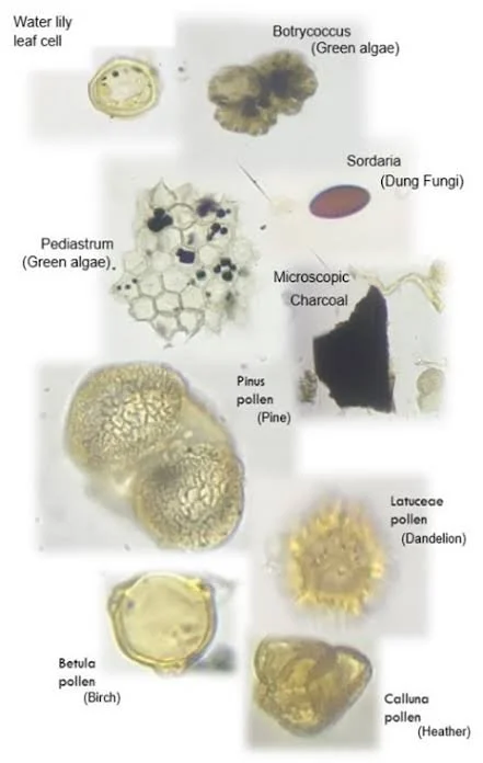
Plants produce pollen with distinctive shapes and surface structures. Under a microscope, specialists can often identify pollen to a family, genus, or sometimes species level.
Different plants produce pollen at different rates and disperse it over different distances. As a result, pollen percentages do not directly represent the exact abundance of every plant in the surrounding landscape.
Nevertheless, changes in pollen composition can reveal important environmental patterns.
A core containing high proportions of grass pollen may indicate open vegetation, while tree pollen can suggest woodland. The presence of salt-tolerant plants may point toward coastal or saline conditions.
Reconstructing Bronze Age Meadows
A submerged meadow can be identified through a combination of pollen evidence and sediment characteristics.
High proportions of grasses and certain herbaceous plants may indicate open ground. Pollen from wetland species can suggest damp or periodically flooded conditions.
If the core also contains freshwater indicators and organic-rich sediment, researchers may infer the presence of a freshwater meadow or marsh.
The interpretation becomes stronger when pollen evidence is combined with plant macrofossils, insect remains, diatoms, and other environmental indicators.
For example, seeds preserved in sediment may provide more precise evidence of local vegetation than pollen alone. Insect remains can reveal whether the area was wet, dry, freshwater, or brackish.
Evidence of Human Activity
Pollen records can also provide clues about Bronze Age land use.
An increase in pollen from plants associated with disturbed ground may indicate cultivation, grazing, or other human activities. Declines in tree pollen may reflect woodland clearance, although climate change and natural disturbance can produce similar patterns.
Some pollen types are associated with agricultural crops. Cereal pollen can provide evidence for cultivation, although it is not always easy to distinguish different cereal species.
The presence of certain weeds may also suggest farming activity.
Researchers must consider the possibility that pollen arrived from distant areas. A small amount of cereal pollen in a coastal core does not necessarily prove that crops were grown directly beside the sampling location.
Coastal Grazing and Pastoral Economies
Meadows and wetlands could have provided valuable grazing resources.
Livestock might have been moved toward coastal areas during particular seasons, especially where grass remained available during dry periods elsewhere.
Salt marshes and coastal grasslands could support animals adapted to these environments. However, grazing conditions would depend on flooding frequency, soil salinity, and the availability of fresh water.
Evidence for pastoral activity may include dung-related fungal spores, changes in vegetation, animal remains, and archaeological features associated with livestock management.
When several indicators occur together, researchers can investigate whether a submerged meadow was used as pasture during the Bronze Age.
Dating the Sediment Record
A reliable environmental reconstruction depends on accurate chronology.
Radiocarbon dating can be applied to suitable organic material preserved in sediment, such as peat or plant remains.
Researchers may also use other chronological techniques depending on the age and composition of the deposits.
Dating multiple levels within a core helps establish how quickly sediment accumulated and when major environmental changes occurred.
However, old carbon can sometimes be transported into younger deposits. Marine environments may also create dating complications because organisms can incorporate carbon from seawater with a different apparent age.
For this reason, dating results must be calibrated and interpreted in relation to the local geological setting.
Sea-Level Change and Human Settlement
Reconstructing submerged meadows can help archaeologists understand how coastal communities adapted to environmental change.
Rising sea levels may have gradually reduced available land, changed access to freshwater, or transformed familiar grazing areas.
Some communities may have moved settlements inland or toward higher ground. Others could have adapted their economies by shifting toward fishing, maritime trade, or different agricultural practices.
However, coastal change should not automatically be treated as the cause of settlement abandonment. Social conflict, economic shifts, disease, and political developments may also have influenced population movements.
The strongest interpretations combine environmental evidence with archaeological settlement records.
Recovering Submerged Landscapes
Researchers use several methods to locate former coastal environments.
Seabed mapping, sediment coring, geophysical survey, and underwater archaeological investigation can identify buried landforms and deposits.
Sonar systems can reveal submerged channels, terraces, and other features beneath the seabed. Core samples then provide information about the materials and environmental conditions associated with these landforms.
In shallow coastal waters, divers or remotely operated equipment may help document archaeological remains.
The process requires close cooperation between archaeologists, geologists, palaeoecologists, and marine scientists.
Limitations of Pollen Records
Pollen records are powerful but imperfect.
Some plants produce large amounts of pollen that travel long distances, while others are poorly represented. Preservation conditions also vary.
Sediment disturbance can mix pollen from different periods. Erosion may remove older deposits, while redeposition can introduce ancient pollen into younger layers.
For these reasons, pollen should not be interpreted in isolation.
The most reliable reconstructions combine pollen with sedimentology, plant macrofossils, microfossils, geochemical data, and archaeological evidence.
Conclusion
Submerged Bronze Age meadows preserve valuable evidence of coastal environments that disappeared as sea levels and shorelines changed.
Pollen records from sediment cores can help reconstruct the vegetation of these landscapes, identify possible grazing areas, and investigate the relationship between human activity and environmental change.
The study of these deposits demonstrates that archaeological landscapes do not end at the modern shoreline. Some former fields, wetlands, and meadows now lie beneath coastal waters, preserving traces of environments that supported human communities thousands of years ago.
By combining palaeoecology, geology, and archaeology, researchers can recover parts of these vanished landscapes and better understand how Bronze Age societies adapted to the changing boundaries between land and sea.