Introduction
The Tsankawi section of Bandelier National Monument presents one of northern New Mexico's most extraordinary archaeological landscapes.
Here, trails cross a volcanic mesa where ancestral Pueblo people carved pathways into soft tuff, created cavate rooms, constructed a mesa-top village, and produced rock imagery.
The modern visitor experiences Tsankawi partly through movement.
The trail climbs.
It passes through narrow passages.
It follows ledges.
It reaches ladders.
It crosses exposed sections of mesa.
And along the route are archaeological traces of people who lived here centuries ago.
The National Park Service describes Tsankawi as an ancestral landscape connected to the modern San Ildefonso Pueblo community. Archaeological and cultural evidence indicates that ancestral Pueblo people lived here and adapted the soft volcanic landscape for homes, trails, and farming.
Tsankawi and the Volcanic Mesa
The geology of Tsankawi shaped nearly every aspect of human activity.
The mesa is composed largely of volcanic tuff.
This rock is relatively soft compared with many other Southwestern geological formations.
That made it possible to carve:
hand-and-foot holds
narrow pathways
cavates
stair-like passages
niches
architectural features
The result is a landscape in which natural and artificial features blend together.
A modern visitor may not always know where geological erosion ends and human modification begins.
Archaeological investigation helps distinguish the two.
The Ancient Trails
The trails are among Tsankawi's most important features.
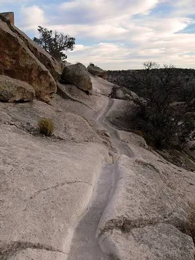
The National Park Service states that the current route follows trails used by ancestral Pueblo people and includes narrow trenches and ladders.
These trails demonstrate repeated movement.
Human feet can gradually modify soft rock.
Where people repeatedly walked, climbed, or descended, the surface could become more pronounced.
Handholds could be carved to make difficult sections easier.
The result is an archaeological record of movement itself.
Why Trails Matter Archaeologically
Archaeology often focuses on stationary objects.
Houses are excavated.
Pottery is analyzed.
Tools are catalogued.
Burials are studied.
But movement is equally important.
Trails reveal relationships between places.
A pathway connecting a village with agricultural fields tells us something about daily work.
A route connecting houses with water sources reveals practical organization.
A trail leading to a ceremonial location may reflect ritual movement.
Therefore, Tsankawi's paths provide information about how the community occupied its landscape.
Cavates Along the Route
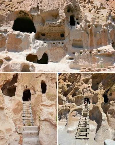
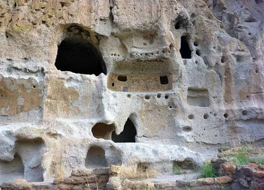
The trail also passes archaeological cavates.
These are rooms intentionally carved into the soft volcanic rock.
Some may have been residential.
Others may have served storage or specialized purposes.
The presence of multiple rooms along cliffs indicates that the landscape was actively constructed and maintained.
Cavates also provide evidence of technological adaptation.
Instead of transporting enormous quantities of building material, people could use the existing rock formation as part of the architecture.
Petroglyphs
Tsankawi's rock imagery adds another dimension.
Petroglyphs are images carved or pecked into rock.
The techniques used to create them could include repeatedly striking the surface with a harder stone, scraping, grinding, or removing weathered rock to expose a lighter surface beneath.
Over time, natural weathering changes the appearance of the imagery.
This creates an important archaeological clue.
A freshly exposed surface is generally lighter than an older weathered surface.
However, weathering alone cannot provide a precise date.
What Do the Images Mean?
This is one of the hardest questions in rock-art archaeology.
An image of an animal might represent:
an actual animal
a symbolic being
a mythological concept
a clan association
a hunting context
a ceremonial reference
something whose meaning is now unknown
A human figure might have social or ceremonial significance.
Geometric designs could carry meanings that are impossible to reconstruct without cultural context.
Archaeologists must therefore resist the temptation to create imaginative translations.
Indigenous Perspectives
The interpretation of Tsankawi becomes much richer when Indigenous perspectives are included.
The National Park Service emphasizes that Tsankawi remains connected to Pueblo descendants and contains tangible and intangible connections to the past.
This is particularly important for rock art.
A petroglyph is not necessarily simply an "ancient drawing."
It may be part of a cultural landscape whose meaning extends beyond what archaeological observation can recover.
Modern descendants may understand ancestral landscapes through traditions that are not represented in archaeological publications.
The Mesa-Top Village
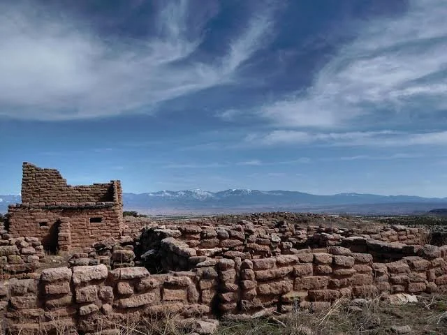
At the top of Tsankawi is the archaeological village.
This settlement provides evidence that the trails were part of a larger community.
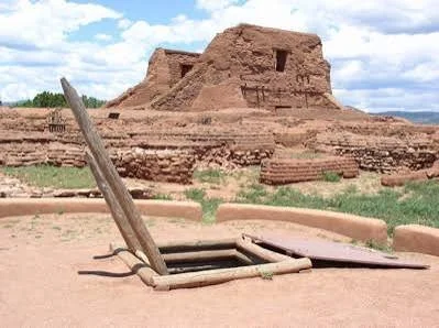
The National Park Service describes the village as an ancestral Pueblo settlement situated on the mesa.
The relationship between village and cliff is particularly interesting.
People could live on the mesa while using the cliffs below for additional rooms, pathways, and other activities.
The settlement therefore occupied multiple vertical levels.
Agriculture
The mesa environment was not particularly easy for farming.
Yet ancestral Pueblo communities developed agricultural strategies suited to the region.
Dry farming required close attention to rainfall and soil.
People could exploit shallow depressions and areas where runoff accumulated.
They could also select locations based on slope orientation and soil properties.
Agriculture was therefore a highly knowledgeable activity rather than simply planting crops and waiting for rain.
Water
Water was always critical.
Rainfall in northern New Mexico can be highly seasonal.
Storms can produce intense runoff but not necessarily provide reliable year-round water.
Communities therefore needed to understand local water sources.
Water could come from springs, streams, seasonal pools, collected runoff, or other sources.
Storage was equally important.
A community's ability to survive drought depended partly on how effectively it could preserve food and manage water.
The Broader Bandelier Landscape
Tsankawi cannot be isolated from the rest of Bandelier.
Frijoles Canyon and other parts of the monument contain related archaeological evidence.
The broader landscape preserves evidence of ancestral Pueblo occupation extending over centuries.
Bandelier's archaeological history demonstrates that communities repeatedly adapted to changing environmental and social conditions.
Dating Tsankawi
Archaeologists use multiple methods to establish chronology.
Ceramics are particularly important.
Pottery styles changed over time and can be compared with dated archaeological contexts.
Tree-ring dating can also provide precise dates when suitable wood survives.
Architectural styles provide additional clues.
Radiocarbon dating may be used on organic materials.
No single method is perfect.
Archaeological chronology becomes stronger when several independent lines of evidence agree.
Preservation of the Trails
Tsankawi's greatest archaeological vulnerability is also one of its most obvious features: the trails themselves are fragile.
The volcanic tuff is soft.
Repeated footsteps can accelerate erosion.
The National Park Service specifically warns visitors to remain on designated trails because the underlying rock is highly susceptible to erosion from footwear.
This means that simply wandering off the trail can damage the archaeological landscape.
The problem is especially serious because an informal shortcut may eventually become a permanent erosion channel.
Modern Graffiti
One of the most damaging threats to rock art is graffiti.
Modern names carved into the same surfaces as ancient petroglyphs can destroy archaeological information.
The damage is irreversible.
The National Park Service notes that new names carved across or near ancestral evidence can be particularly painful for Pueblo descendants because of the cultural relationship between the place and their ancestors.
This is an important reminder that archaeological preservation is also cultural preservation.
The Experience of Walking an Ancient Landscape
Tsankawi is unusual because visitors experience archaeology through their own bodies.
They climb the same kinds of routes.
They pass the same cliffs.
They encounter the same geological formations.
They see the same broad landscapes.
The experience does not mean that modern visitors are literally recreating ancient life.
Modern hiking equipment, safety systems, infrastructure, and expectations are completely different.
Nevertheless, the trail offers a rare physical appreciation of how difficult and skillful movement across the ancient landscape could be.
Conclusion
Tsankawi's petroglyph trails demonstrate that archaeology is not limited to buildings and artifacts.
A trail can be an archaeological feature.
A handhold can be archaeological evidence.
A carved room can be architecture.
A petroglyph can be a record of symbolic activity.
A mesa can be both an agricultural landscape and a place of cultural memory.
Together, these features reveal a community that understood its environment intimately.
Tsankawi is therefore best understood not as a collection of isolated ruins but as a connected cultural landscape.
Its trails, cavates, petroglyphs, village remains, and agricultural areas represent different parts of the same human story.
And because that story remains connected to modern Pueblo communities, protecting Tsankawi means preserving not only archaeological information but a landscape of continuing cultural significance.