In this video we will discuss the limitations of paleontology and science and speculate what could be missing or lost to history and time. Could there have been civilizations or cultures made by other non-human organisms? Watch the video to find out!

When Did the Exodus Happened According to Experts?
BY THE ARCHAEOLOGIST EDITOR GROUP
Deciphering the Exodus: What Historians and Archaeologists Say About Its Timeline
The precise date of the Exodus, as narrated in the Bible, remains one of the most debated topics in biblical archaeology and Egyptology. While the story is central to Jewish, Christian, and Islamic traditions, determining an exact historical timeframe for the event has proven elusive due to the lack of direct archaeological evidence and ambiguities in the biblical text.
Different experts have proposed various timelines based on interpretations of biblical chronology, external historical events, and archaeological data.
1. Late Bronze Age (15th Century BCE): Some scholars, using the biblical chronology, place the Exodus around 1450 BCE. 1 Kings 6:1 states that Solomon began building the Temple in Jerusalem 480 years after the Israelites came out of Egypt. Since Solomon's reign is commonly dated to around 970–931 BCE, this would place the Exodus in the mid-15th century BCE. This is often referred to as the "early date."
2. Late Bronze Age to Early Iron Age (13th Century BCE): Other scholars advocate for a 13th-century BCE date for the Exodus during the reign of Ramesses II. This is based on several factors:
The city of Pi-Ramesses in the Nile Delta, mentioned as a city the Israelites worked on, flourished during the reign of Ramesses II.
The archaeological and socio-political situation in Canaan during the Late Bronze Age-Early Iron Age transition aligns better with the biblical conquest narratives.
This timeframe, often called the "late date," is currently more favored among scholars who argue for a historical basis for the Exodus narrative.

3. Alternative Theories: Some scholars, noting the lack of direct evidence for a large-scale migration as described in the Bible, have proposed alternative theories:
The Israelites were already in Canaan and emerged as a distinct group over time, possibly as a socio-political and religious uprising against Canaanite city-states.
The Exodus narrative represents a fusion of several smaller migration and liberation stories over various periods.
4. Archaeological Perspective: Many modern archaeologists note the lack of direct archaeological evidence for the Exodus as described in the Bible. There's currently no conclusive evidence of large-scale Israelite settlements in Egypt or a sudden mass migration into Canaan during any specific period. However, the absence of evidence is not evidence of absence, and the debate continues.
5. Symbolic Interpretation: Some theologians and historians see the Exodus narrative not strictly as a historical account but as a foundational and symbolic story crafted to instill a sense of shared identity, destiny, and purpose among the Israelites.
In conclusion, while the Exodus remains a foundational narrative in religious traditions, its exact dating and historical authenticity are debated among experts. Whether viewed as historical reality, symbolic narrative, or a mix of both, its cultural and religious significance is undeniable.

The Assyrian Enslavement of the Hebrews: The Israelites' Struggle in a Foreign Land
BY THE ARCHAEOLOGIST EDITOR GROUP
How the Mighty Assyrian Empire Ensnared the Northern Kingdom of Israel: The Forced March of the Hebrews
In the annals of ancient Middle Eastern history, few empires were as formidable and feared as the Assyrians. Their military prowess, coupled with their brutal tactics, allowed them to subjugate numerous peoples and territories. Among the many nations that felt the weight of the Assyrian yoke were the Israelites, or Hebrews, specifically those of the Northern Kingdom of Israel.
Rise of the Assyrian Empire
Originating from the city of Assur in present-day northern Iraq, the Assyrians expanded their empire aggressively during the 1st millennium BCE. By the 8th century BCE, under kings like Tiglath-Pileser III and Shalmaneser V, the empire had reached the zenith of its territorial ambitions, stretching from modern-day Iran to Egypt.
The Fall of the Northern Kingdom
The Northern Kingdom of Israel, with its capital in Samaria, first became a vassal state of the Assyrian Empire during the reign of Tiglath-Pileser III. Israel's King Menahem paid heavy tribute to avoid a full-scale invasion. However, subsequent kings of Israel, such as Pekah, sought to rebel and form coalitions with other states to resist Assyrian dominance.
These rebellions did not bode well for Israel. Shalmaneser V initiated a siege of Samaria in 725 BCE that lasted three years. His successor, Sargon II, eventually captured the city in 722 BCE, marking the end of the Northern Kingdom of Israel.

Deportation and Assyrian Policy
The Assyrians had a well-established policy when dealing with conquered peoples: mass deportation. After capturing Samaria, Sargon II deported a significant portion of the Israelite population—estimates suggest around 27,000, though the exact number may have been higher—and resettled them in various regions of the Assyrian Empire. This was done to quell any future rebellions and to integrate the conquered populace into Assyrian society.
These deportations effectively dispersed the ten northern tribes of Israel, leading to their historical moniker as the "Lost Tribes of Israel."

Consuming labor in the Assyrian heartland.
Legacy and Implications
The Assyrian conquest had profound implications for the Hebrew people.
1. Cultural and Religious Evolution: The Israelites in exile encountered various cultures, leading to an exchange of ideas and beliefs. While many maintained their distinct identities, others assimilated into Assyrian society.
2. The Emergence of the Southern Kingdom: With the Northern Kingdom obliterated, the Southern Kingdom of Judah, with its capital at Jerusalem, became the primary Hebrew state. This geopolitical shift intensified the centralization of religious practices around the Temple in Jerusalem.
3. Historical and Biblical Significance: The Assyrian exile is referenced in various biblical texts, including the Books of Kings and Chronicles. The prophets of the time, like Hosea and Isaiah, also provided insights, often interpreting the exile as divine punishment for Israel's sins.
Is this the first known deportation of Hebrew people in history?
The Assyrian deportation of the Israelites from the Northern Kingdom of Israel in the 8th century BCE is not the first known instance of Hebrews being displaced or facing subjugation. However, it is among the most significant due to its scale and long-term implications.
Earlier interactions between the Hebrews and other empires resulted in some levels of subjugation, tributary status, or displacement. Notably:
1. Egypt: According to the biblical narrative, the Hebrews were enslaved in Egypt for several centuries before Moses led them out in the Exodus. This account from the Book of Exodus tells of the Israelites' oppression, their eventual liberation, and their journey to the Promised Land. While the Exodus story is foundational for Jewish religious identity, concrete historical evidence for this enslavement and subsequent exodus is sparse and remains a topic of debate among archaeologists and historians.
2. Local Canaanite and Philistine Powers: After settling in Canaan, the emerging Israelite confederation often clashed with neighboring city-states and groups. The biblical Book of Judges recounts cycles of subjugation by neighboring powers, including the Moabites, Midianites, and Philistines, followed by periods of liberation led by various judges.
However, the Assyrian deportation is unique because of its scale and its lasting effect on the cultural and geopolitical landscape of the region. It resulted in the widespread displacement of ten of Israel's twelve tribes, leading to their historical designation as the "Lost Tribes of Israel."
The Assyrian enslavement and deportation of the Israelites from the Northern Kingdom is a testament to the tumultuous and interconnected histories of ancient Middle Eastern civilizations. While the Northern Kingdom of Israel ceased to exist politically, its cultural and religious legacy persisted, contributing significantly to the tapestry of ancient Semitic traditions and beliefs.

Between Myth and Reality: The Hebrews' Enslavement by the Egyptians
BY THE ARCHAEOLOGIST EDITOR GROUP
The Prehistoric Saga of Hebrew Enslavement: Myths, Facts, and Interpretations
The story of the Hebrews' enslavement in ancient Egypt is one of the best-known episodes from the Bible. For many, it serves as a testament to perseverance, faith, and the ultimate triumph of the oppressed over their oppressors. But beyond religious texts, what do we truly know about the initial subjugation of the Hebrews in prehistoric times? This article delves into the origins of the Hebrew enslavement, examining both religious accounts and what historical evidence can offer.
Biblical Account: From Famine to Enslavement
According to the Book of Genesis in the Old Testament, the initial connection between the Hebrews and Egypt began with Joseph, one of the twelve sons of Jacob (later named Israel). Sold into slavery by his jealous brothers, Joseph eventually rose to prominence in Egypt due to his ability to interpret dreams. He foresaw a seven-year famine and advised Pharaoh on measures to prepare for it. Grateful, Pharaoh elevated Joseph to a high-ranking position, and during the famine, Joseph's family migrated to Egypt for sustenance.
For a time, the Hebrews prospered and multiplied in Egypt. However, as the Book of Exodus recounts, a new Pharaoh came to power "who did not know Joseph." Fearing the growing Hebrew population, he enslaved them, marking the beginning of several centuries of bondage.
Historical Evidence and Debates
While the biblical story is rich in detail, its historical accuracy has been the subject of debate among archaeologists and historians. There are several points of contention:
1. Chronology: Determining the exact timeline of Hebrew enslavement is challenging. Different scholars place the Exodus (the liberation of the Hebrews from Egypt) at different periods, ranging from the Middle Kingdom to the New Kingdom.
2. Archaeological Records: Direct archaeological evidence linking the Hebrews to ancient Egypt during the said period of enslavement is scant. There are no Egyptian records that clearly document the enslavement of a people identifiable as the Hebrews.
3. City of Ramses: The Bible mentions that the enslaved Hebrews built the store cities of Pithom and Ramses. Some associate the mention of Ramses with Pharaoh Ramesses II, suggesting a New Kingdom timeline for the enslavement. However, no archaeological evidence directly supports this claim.
4. Semites in Egypt: There's evidence of Semitic peoples in ancient Egypt working in various capacities, including labor. The Brooklyn Papyrus, for instance, lists several Semitic slaves in Egypt. However, whether these were Hebrews or another Semitic group is not specified.
The Evolution of the Narrative
The story of the Hebrew enslavement and the Exodus has evolved over time, with religious, philosophical, and cultural interpretations layering upon the original tale. For believers, the story serves as a testament to divine intervention and the idea that faith and righteousness will ultimately lead to deliverance. Philosophically, it touches upon themes of freedom, resistance against oppression, and the quest for a promised land or a better life.
The enslavement of the Hebrews in prehistoric times, as described in biblical texts, remains one of the most potent narratives in human history. While its historical accuracy might be debated, its cultural and religious significance is undeniable. The story transcends its religious roots, offering timeless lessons on hope, faith, and liberation.

The British Museum recovers some of the 2,000 items that were stolen
The British Museum is believed to have lost 2,000 valuable artifacts, although some of them have already started to be recovered, according to chairman George Osborne.
The former chancellor acknowledged that the museum's reputation had suffered but insisted that "we are going to clean up the problem."
The quantity of items stolen from the museum, according to a renowned expert in stolen antiques, is "mind-blowing."
A museum employee who is suspected of being involved has been fired.
Moreover, it was disclosed on Friday that Hartwig Fischer, the museum's director, will resign as soon as he acknowledges that the 2021 probe was handled improperly.
One of the most esteemed cultural institutions in the UK, the museum, has been under fire since it was revealed earlier this month that a number of priceless artifacts had been reported "lost, stolen, or destroyed."
The objects in question were mostly retained for scholarly and research purposes, and they ranged in date from the 15th century BC to the 19th century AD.
In an interview with BBC Radio 4's Today program, Mr. Osborne, who was appointed chair in June 2021, said: "We believe we have been the victims of thefts over a long period of time, and clearly more might have been done to avoid them."
When questioned about the whereabouts of the missing goods, he responded, "Some members of the antiquarian community are actively cooperating with us," adding that the recoveries made thus far were "a silver lining to a terrible cloud."
Although he recognized that "others may not," he expressed confidence that "honest individuals" would return stuff that had been taken.

Vimanas: The Mystical Flying Machines of Ancient Indian Lore
BY THE ARCHAEOLOGIST EDITOR GROUP
In the annals of ancient civilizations, many have tales of mysterious flying objects and advanced technologies far beyond their time. For ancient India, these stories are intricately woven into the fabric of its rich mythological tapestry, particularly in the form of "vimanas." Often depicted as flying chariots or celestial aircraft, vimanas have ignited imaginations and spurred debates about ancient technological advancements for centuries.
The Etymology and Descriptions
The Sanskrit term "vimana" can be loosely translated as "having been measured out" or "traversing." In early Vedic literature, the term predominantly referred to a temple's central structure or the palace of a deity. However, over time, its usage expanded to describe a more intriguing concept: aerial vehicles that traversed the sky and even space.
In ancient Indian texts, vimanas are depicted in various forms, ranging from bird-like structures to palatial flying chariots adorned with wings. Some accounts even describe them as vast cities floating in the sky, complete with gardens and courtyards.
Literary Mentions
Several ancient Indian scriptures, epics, and other texts reference vimanas:
Rigveda: One of the oldest ancient Indian scriptures, the Rigveda, mentions mechanical birds and flying chariots.
Ramayana: This epic chronicles the hero Rama's adventures and references vimanas, most notably the "Pushpaka Vimana," a magnificent flying chariot that could change its form.
Mahabharata: Another seminal epic, the Mahabharata, contains multiple references to aerial battles and sophisticated vimanas.
Vaimnika Shstra: Often cited by enthusiasts and researchers, this early 20th-century Sanskrit text provides detailed schematics and descriptions of vimanas. While it claims to be based on older texts, its authenticity and origins are topics of debate among scholars.
Technological Marvels or Mythological Symbols?
Vimanas, given their detailed descriptions and recurring presence in ancient texts, have sparked intense debates among historians, researchers, and enthusiasts. Three primary interpretations prevail:
1. Symbolic Representations: Some scholars argue that vimanas are purely symbolic, representing spiritual mastery, enlightenment, or the prowess of deities and celestial beings.
2. Historical Records: A contrasting view suggests that these accounts might be distorted records of advanced technological innovations lost over time or interactions with advanced civilizations.
3. Extraterrestrial Contact: Riding the wave of ancient astronaut theories, some propose that vimanas are evidence of ancient India's contact with extraterrestrial beings.
Influence on Popular Culture
The concept of vimanas has not remained confined to ancient texts. They have permeated modern pop culture, inspiring books, films, and TV shows. The allure of advanced ancient civilizations with flying machines fits seamlessly into science fiction and fantasy narratives.
Vimanas, whether viewed as mythological wonders or potential evidence of advanced ancient technologies, undeniably captivate the imagination. As with many ancient tales, they remind us of humanity's enduring fascination with flight, the skies, and the boundless possibilities of the universe. They stand as a testament to ancient India's rich storytelling tradition, where the lines between mythology, spirituality, and history often beautifully blur.

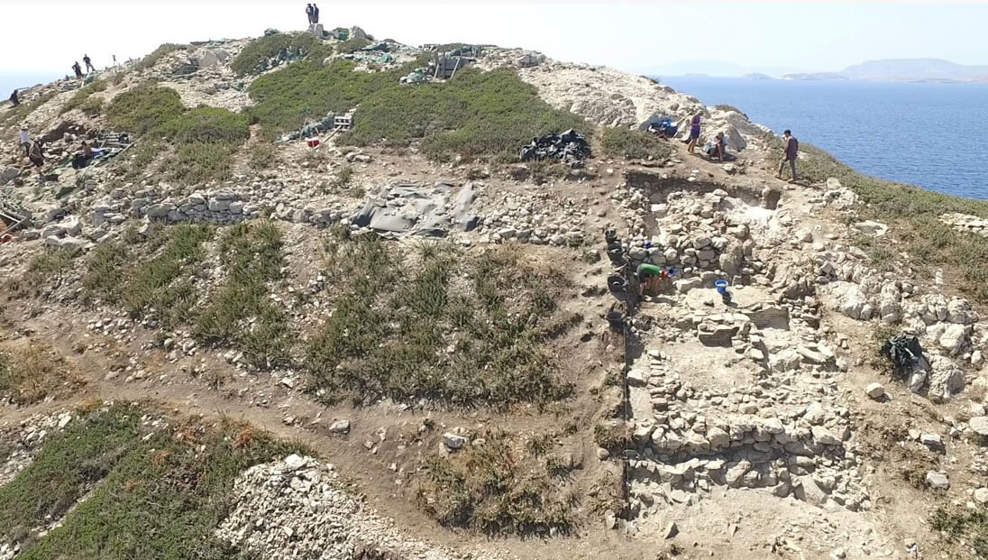
View of Daskalio, the ancient natural promontory of the island of Keros, which has the shape of a pyramid. Photo: University of Cambridge
Intricate Ancient Engineering and Metallurgy Under the "Pyramid" of Islet Daskalio
BY THE ARCHAEOLOGIST EDITOR GROUP
At least 4,000 years ago, builders carved the entire surface of Daskalio, the ancient natural promontory of the island of Keros, which is shaped like a pyramid.
They fashioned it in levels, which they covered with 1,000 tons of special imported glittering stone to give the appearance of a huge stepped pyramid, rising into the Aegean, forming the most imposing man-made structure in the entire Cyclades archipelago. But beneath the surface of these levels lay something equally unique: Archaeologists from three different countries, participating in an ongoing excavation, have discovered evidence of a complex of drainage tunnels – built 1,000 years before the famous Minoan palace plumbing. Knossos-, as well as traces of advanced metallurgy.
The above was published on its website by the Guardian, referring to the continuation of a particularly interesting excavation that is constantly bringing new impressive findings. The publication goes on to provide information about the area: Daskalio, a small rock island today next to Keros, with which, 4,500 years ago, it was joined by a small passage; and the island that, in the 3rd millennium BC, was a very important sanctuary where complex rituals took place.
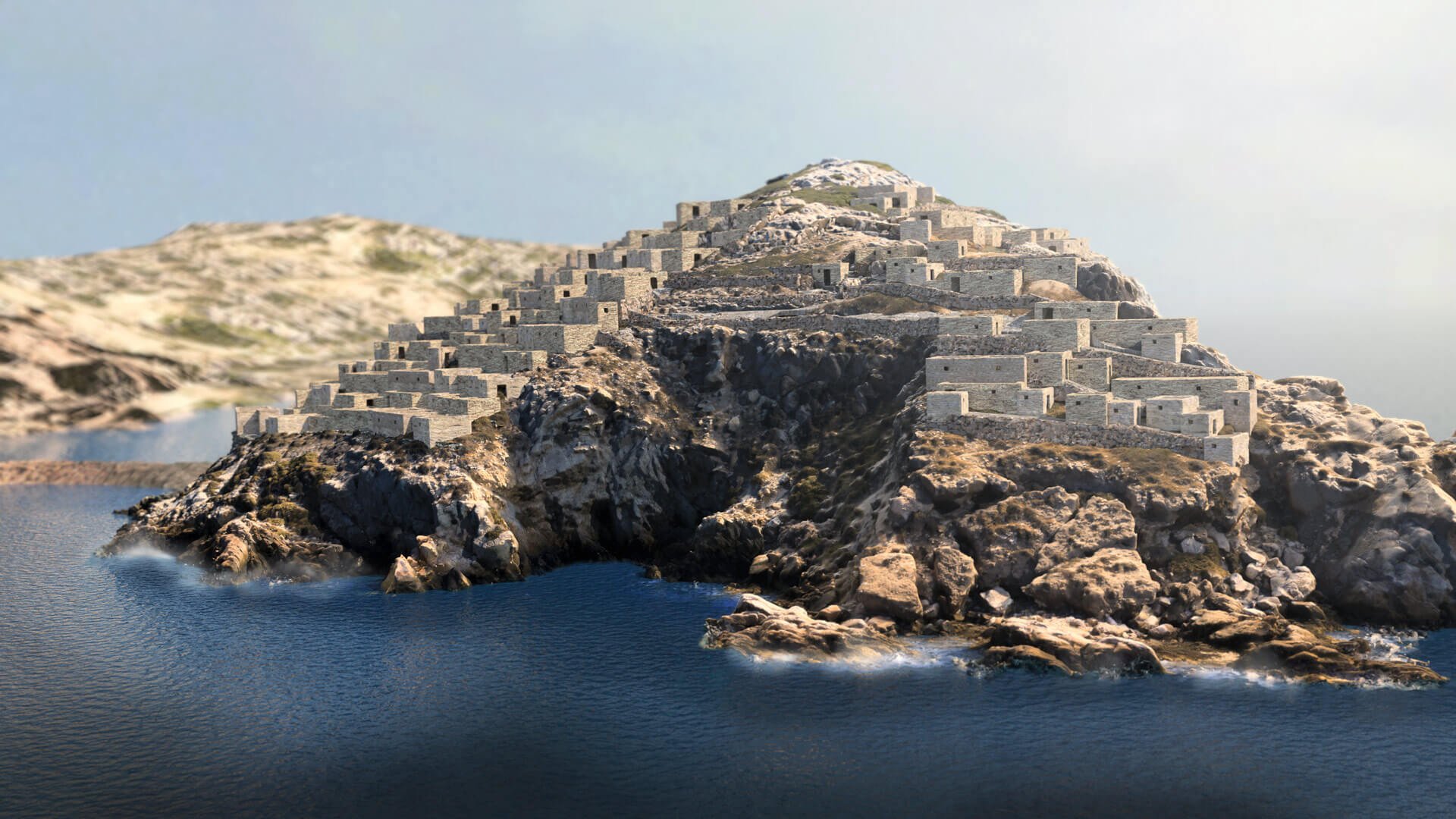
3D visualization of the ancient village on the islet of Daskalio. Credit: Greek Ministry of Culture and Sports
Lord Colin Renfrew, co-director of the excavations, founding director of the Macdonald Institute of Archaeological Research, Cambridge, and one of the world's most distinguished archaeologists and researchers, has declared that Keros is the "world's oldest island sanctuary". In fact, in the interview he gave at the beginning of September in Greek media on the occasion of his eightieth birthday, he said, among other things, "There are other island sanctuaries in the world, but none are as old as Keros."
In previous excavations carried out in Keros by the Cyclades Antiquities Ephorate, in collaboration with the University of Cambridge and the Cyprus Institute, thousands of Cycladic marble figurines, which had been deliberately broken elsewhere and brought to the island, were brought to the surface. According to the publication, the construction, as well as the maintenance of the settlement, should have been done through a community effort. The now-abandoned slopes of Daskalio were once covered with buildings and constructions, which suggests that 4,500 years ago it was one of the most densely populated places in the Cyclades, even though the place was not self-sufficient in food and raw materials, which had to be imported from somewhere else.

Professor Colin Renfrew on the summit of Daskalio (source: Ministry of Culture and Sports/British School at Athens).
The first signs of metalworking were discovered 10 years ago, while more recent finds have brought to light two workshops filled with metal scraps and artifacts, including a lead axe, a mold for bronze knives, and dozens of ceramic fragments of metallurgical equipment, including a mouthpiece for a blowtorch. Later, at the end of the earlier excavation period, an intact clay oven was found. According to excavation co-director Michael Boyd, from the University of Cambridge, metallurgical know-how was apparently concentrated in Daskalio at a time when access to both skills and raw materials was very limited, citing finds linked with the origins of urbanization.
The pyramidal levels would have shone in the Greek sun, visible from far away, as they were clad in white marble from Naxos, which is 10 kilometers away. The complex of drainage tunnels was discovered when archaeologists excavated an imposing staircase to the lower levels, and is being investigated as to whether it is fresh water or sewage.
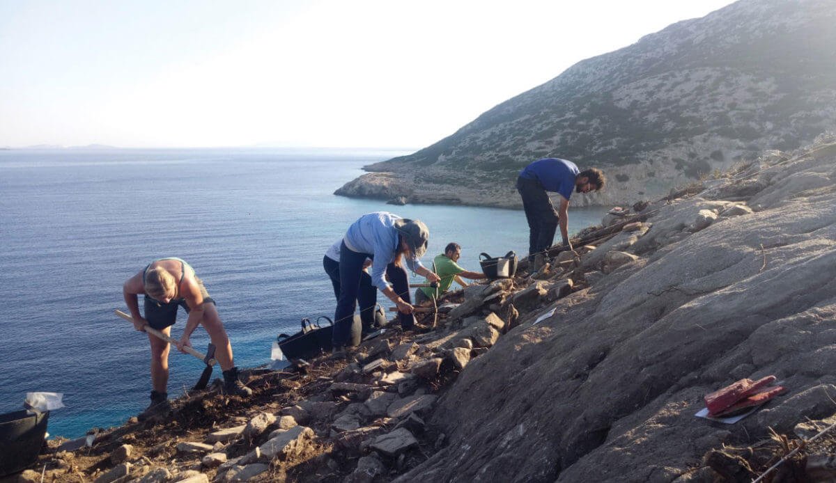

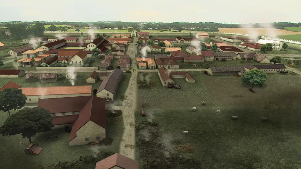
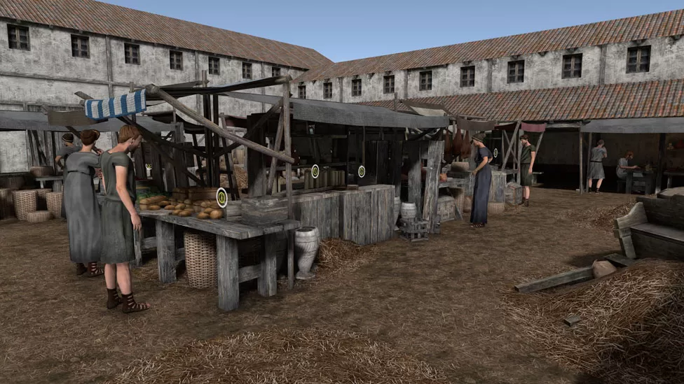
Roman Caistor: A dig is revealing the town's Iron Age past
A community excavation is uncovering evidence of Iron Age activity at a location well known for its fortified Roman colony.
Venta Icenorum - as the Romans called it - had running water, baths, a town hall and a forum and was enclosed in walls in the 3rd Century
The largest Roman town in East Anglia was located in Caistor, Norfolk. Every summer, a combination of villagers and archaeologists excavate it.
The area surrounding the fortified site is the subject of the dig.
Iron Age artifacts and "some sort of road," according to project director Will Bowden, have been found, providing "a sense of pre-Roman activity."

Before that it was surrounded by defensive ditches and this is the area the excavation is concentrating on
"One of the most intriguing areas of the Roman town" is the focus of the community archaeological organization Caistor Roman Project.
When the town was first established in the early AD 70s, it was encircled by a 2.4 km (1.49 mi) wide circuit of ditches rather than walls.
The community archaeology team have been excavating the site since 2006
It wasn't until the third century that its walls were erected.
It is a crucial location, according to project director Prof. Bowden, a Roman archaeology expert from Nottingham University.

Prof Will Bowden said while it is early days, their latest finds are giving them "a real sense of what's going on in this field"
"We've always known this is an important area of the Roman town, and excavations on this land in the 1930s demonstrated this had some of the earliest activity associated with the town in the very late Iron Age or early Roman period," he added.
We are interested in learning how the town grows, what existed here in the past, how the community develops, and why it is currently just a green field.

The defensive ditches surrounded an area much greater than the later walls
The Iceni, best known for their leader Boudicca, who led a revolt against the Romans in AD61, built "one of the largest" temple constructions in Roman Britain close to the site.

Archaeology student Kelsey Middleditch is enjoying putting her learning into action
An archaeological student at the University of East Anglia named Kelsey Middleditch has so far assisted in the discovery of what appears to be cobblestone paving and some horse teeth.
You don't even have to be an archaeology student or particularly interested in history to participate, she said.
It was occupied until the 8th Century, when it was abandoned and Norwich became the county's civic centre
Rare Stone Age find in the middle of Norway
Archaeologists recently unearthed a startling discovery in Vinjeøra in southern Trøndelag County that they had only ever dreamed of discovering.

Flint objects with completely straight and parallel side edges told archaeologists that what they had found was extra exciting. Credit: Silje Elisabeth Fretheim
The initial finds, enormous shards of flint that were strikingly suggestive of early, pioneer villages, appeared to be very promising.
But it soon became apparent that Silje would be closer than anyone had thought to swallowing her hard helmet. What they had discovered was completely different and far more interesting.
Individuals from the east
When the excavations in Vinjeøra started up properly, the researchers at once found objects that had entirely different characteristics and did not resemble anything that would be expected from a pioneer village.
Small and medium-sized flint artefacts, also known as lithics and microlithics, were discovered. A ruler could have been used to make some of the sharp edges on several of the artifacts, according to Fretheim, an archaeologist at the NTNU University Museum.

Archaeologists don't just dig with a shovel. Here, the top layer of soil in the excavation area is removed before the "fine digging" begins. Credit: Silje Elisabeth Fretheim
There was little question that we had found a different form of stone technology than we identify with pioneer culture because we also found a conical lithic core, the researcher added.
The researchers instead discovered evidence from humans who arrived in Finnmark from the east around 9000 BC.
Two migratory waves
In comparison to the rest of Europe, Scandinavia saw the longest periods of ice during the previous Ice Age. Around 12,500 years ago, the Norwegian shore finally stopped being covered in ice. About a thousand years later, the first people began to settle in what are today known as Sweden and Norway.
Previous skeletal studies have demonstrated that during the period after the ice began to retreat, Scandinavia saw two significant waves of migration. Southwesterly was the first to arrive. It was composed of individuals who had lived in present-day Spain and Portugal during the last Ice Age and had later relocated to the north as the ice retreated. They had blue eyes, but darker skin than modern Scandinavians.
In a matter of a few centuries, they "populated the entire Norwegian coast up to Finnmark," according to Fretheim.

This is a type of stone hammer, a tool flint smiths used to shape tools. The technique used by the eastern immigrants was quite difficult. It’s something you have to be trained in, it’s not something you can copy just by looking at a tool, Fretheim said. Credit: Silje Elisabeth Fretheim
A further significant wave of migration occurred a thousand years later, this time coming from the northeast. These were individuals who had moved north through Russia and Finland to the coast of Finnmark from regions near the Black Sea or Ukraine. They had paler complexion, and the hues of their eyes varied.
They used a unique method for making stone tools that was obviously distinct from the methods used by the migrants from the south. This method gradually gained control and became prevalent.
It appears that when the two cultures came together, they each had something to teach the other. The people from the east brought new technology, whereas those from the south were familiar with the environment and way of life along the shore, which the people from the east must have been unaware of, according to Fretheim.
During the early centuries, it appears that the people from the east adopted the way of life of those who already lived here and led nomadic lives in lightweight homes, possibly tents. Like the southern pioneers, who relied on the sea for their nourishment, they were likely dependent on boats.
According to Fretheim, "DNA studies also show that the two groups mixed."
Unusual discovery
Why, then, are artifacts from the Eastern wave of immigration so thrilling to find?
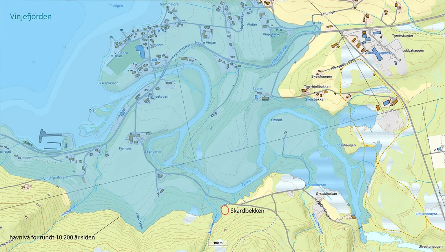
This map shows what the sea level—and shoreline—was like 10,200 years ago. The red ring shows the excavation area at Skardbekken. Credit: Silje Elisabeth Fretheim
While many artifacts from southern migrants—the pioneer culture—have been discovered along Central Norway's outer shore to the south of Trondheim Fjord, Fretheim notes that there have been almost no discoveries in that area that can be positively linked to the early migrants from the east.
One example, according to Fretheim, is a small town in Malvik near Foldsjøen that was unearthed during the 1980s.
The absence of evidence from the eastern immigrants on the outer coast is not mysterious. Most of the evidence of settlement along Norway's western coast between 8500 and 7000 BC has vanished, been washed away, degraded, or been buried in beach sand due to changes in sea level in the years that followed the Ice Age.
Because of this, Fretheim claims that there aren't many finds made by these people between Finnmark and Eastern Norway.
However, she added, "Deep in the fjords, the uplift progressed differently, and settlements here were preserved as a result."
The archaeologists haven't been able to concentrate their search for settlements from the people from the east since they are unable to choose where to excavate on their own. This is because excavations for archaeology are typically done in conjunction with the construction of new structures or buildings. For instance, this excavation is being done as part of the Norwegian Public Roads Administration's construction of the new E39 expressway through Vinjera.
"We were dealt a perfect hand here," said Fretheim. "We have dreamed of finding this for a long time."
For dinner, a hard hat?
I had to put Fretheim on the spot since this author takes her duties as a journalist seriously. Should she eat her hard hat?
“Based on the nearby beach displacement curve, we are now dating the town to be between 10,200 and 10,300 years old. Because of this, even if the settlement was different than I had anticipated, I have narrowly escaped having to eat my hard hat”, she added.
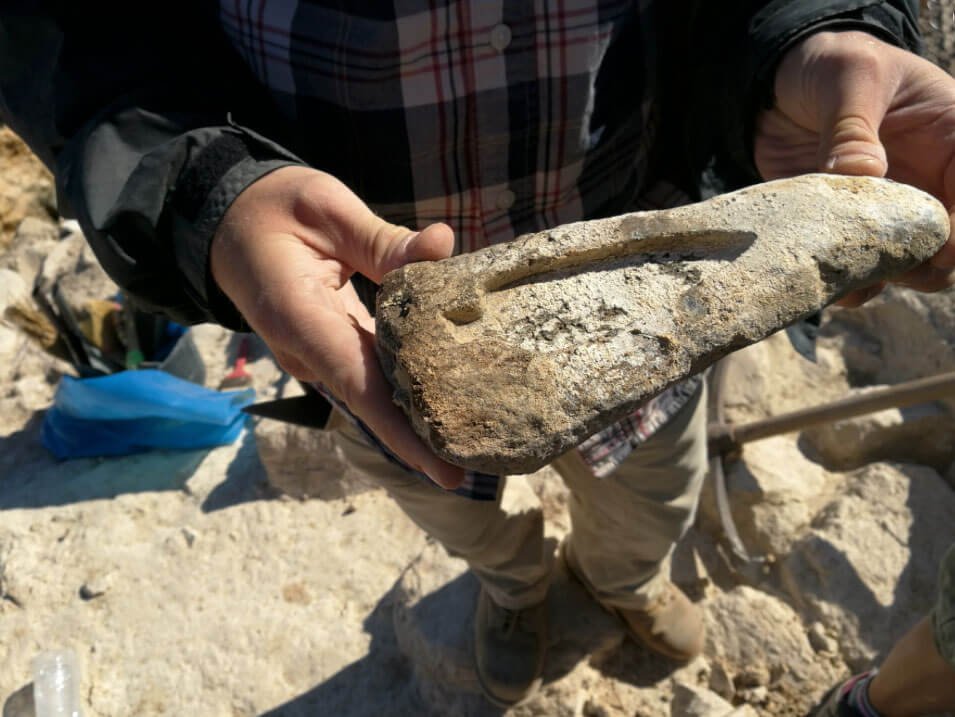
Ancient Architectural Drawings Reveal Construction Methods of Mysterious Megastructures
Large megastructures called as "desert kites" were fashioned into the stony terrain in the Middle Eastern deserts more than 8,000 years ago. Archaeologists just found the world's earliest architectural plans that explain how prehistoric people were able to build these enormous constructions.

A stone found in Jordan engraved with the plan of a desert kite.
Only in the 1920s, when airplanes were flying over the deserts, did they discover the existence of desert kites. Although the purpose of these structures has long baffled archaeologists, it is now thought that they were set up along migratory pathways as animal traps to capture herds of gazelle, antelope, and other game animals.
They are simply rock and dirt walls that can be up to 5 kilometers (3 miles) long. From the ground, they don't look like much, but from above, they take on the appearance of a massive pattern.
It was previously unknown how prehistoric humans planned and built the constructions without being able to view them from the air because of their magnitude. But this is being explained by the recent discovery of two engravings in Saudi Arabia and Jordan.
Two 8,000+ year old desert kites can be seen at Zebel az-Zilliyat in Saudi Arabia, which is located about 3.5 kilometers (2 miles) apart. Additionally, 382 centimeters (nearly 150 inches) long engravings that appear to be scale designs of the desert kites have been discovered here by experts.
If this interpretation is accurate, the engravings represent the earliest scaled plans that have ever been discovered.
The development of organized civilizations and the development of agriculture during this period was a crucial turning point in the history of humanity. The finding of these architectural blueprints, according to the researchers, looks to be a turning point in human intelligence. The engravings demonstrate that the construction of the desert kites was organized and required abstract thought and audacious imagination, as opposed to being a hasty blunder.
"These representations shed new light on the evolution of human discernment of space, communication, and communal activities in ancient times," the study's authors write in their report.
"Although human structures have altered natural areas for thousands of years, Mesopotamia and Ancient Egypt's literate civilizations are the earliest known to have created blueprints or maps. One significant development in intelligent behavior is the capacity to compress a huge space onto a constrained, two-dimensional surface. Such constructions can only be viewed in their entirety from the air, but this necessitates the portrayal of space in a way that hasn't been done before, according to their statement.
The report has been released in the PLOS ONE publication.
New information is revealed about the Ulster Kings' residence at Navan Fort
The kings and queens of Ulster resided in this location for centuries.

Navan Fort, a large circular earthwork on top of a drumlin, was a significant religious site during the Iron Age
Archaeologists have recently been attempting to put together the exact layout of the structure and the time period during which it was occupied.
The site may have been occupied as early as the 4th Century BC, according to the physical evidence that has reportedly been discovered.
In 2020, the location underwent magnetic gradiometry and electrical resistance surveys, which marked a significant advancement.
This revealed clues to the existence of enormous Iron Age temples and other religious complexes.
This month, academics from Queen's University, Belfast, went back to Navan Fort to participate in an excavation where they think they found proof of this.
The "Ceremonial Center"
On the hilltop site, four new trenches have been opened for this year's dig.
Dr. Patrick Gleeson, an archaeologist, said: "What we are learning is that some of the early periods here are actually very exceptional.
They are possibly unique in terms of the sophistication of some of these monuments on this island; we only know of one or two other parallels.

Dr Patrick Gleeson is part of the research team which is trying to interpret the history of the ancient site
Iron Age massive constructions are extremely hard to discover, especially given their Iron Age date.
The Iron Age spanned around 800 BC to 43 AD, when the Romans invaded Britain.
Dr. Gleeson told BBC News NI he thought the dig's results were noteworthy, but they will need to be taken away and carefully examined.
He stated, "Right now it appears that we have an entirely new early to mid-Iron Age monumental horizon to the complex."
"Everything that you see on the site today dates to roughly 95 BC or later.
'What we have found is that some of the buildings that were unearthed in the 1960s sit within a massive sequence of timber palisaded enclosures from the 4th to the 1st Century BC in terms of dating range.
They are made up of substantial structures perched on a hilltop, enclosed by a huge 160-meter-diameter figure-of-eight enclosure, with enormous timber posts outlining the perimeter of the site.
Site A refers to one of the ditches.
It is a mysterious construction, according to Dr. Gleeson.
"We would anticipate a ring barrow to be a burial monument, but it appears to be a ring barrow instead.
In light of this, we are looking into the monument's bank and ditch. Therefore, it might have been employed for industry, post-medieval activities, or even early medieval residential constructions.
The discovery, according to Dr. Gleeson, will advance "our understanding of the site."

Navan Fort is a part of The Royal Sites of Ireland, a group of six pre-historic sites
"But it also confirms some of the suspicions that have been growing over the last few decades that, rather than this being a residential center of the Kings of Ulster, it actually appears to be a ceremonial center of paramount ritual and religious significance," he continued.
In the medieval era, it eventually changes into a more residential and symbolic center. That enables us to contextualize it both in an Irish and a north-western European perspective.
"Really thrilling"
Navan Fort is currently on the tentative list with five other Royal Sites of Ireland, and it is hoped that one day it will be added to the list of World Heritage Sites.
The participants in the dig are aware of the importance of the initiative.
As an excavator on this year's dig, PHD candidate Louise Moffett is holding a shovel in her hand.
She exclaimed, "It's extremely thrilling.
"Most of the sites I've worked on in the past nobody has heard of, but now everyone knows the site that I've dug at," the author said.

Dr Cormac McSparron keeps drawings of the discoveries while student Louise Moffett is an excavator
"Right now, I'm digging a feature out of this trench's back.
"We found some of the edges, so it's basically about finding those edges to work out the circumference of the feature then following them down until you find the base," she continued.
"However, you only partially excavate it, leaving us with a flat surface known as a section. This allows us to determine whether the feature is made up of several layers that have been added over time, or if it is just one deposit.
Dr. Cormac McSparron is perched on the edge of the trench, a sketchbook in his hand. Later, his sketches will help with the creation of three-dimensional models of discoveries.
This is only a basic sketch design that is a little bit below publication level, he explained.
"I'm just going to note all the numbers. It is merely a brief plan that will be included in the 3D model later.
The trenches will be filled in once the digging is finished.
Gaps in our understanding of this incredibly extraordinary place are hoped to follow.
Roman walls from 2000 years ago were uncovered in Zug, Switzerland
In Cham, a municipality in canton Zug, walls from a Roman building complex constructed around 2000 years ago were found in a gravel pit. The discovery is "a sensation," according to the canton's Office for Historical Monuments and Archaeology in canton Zug.

The discovery of the 2000-year-old Roman wall in canton Zug is "a sensation", says the Office for Historical Monuments and Archaeology. © Keystone / Urs Flueeler
Since there are so few known Roman artifacts in the Alps' foothills, this find is "extraordinary." According to Gishan Schaeren of the cantonal archaeology office on Tuesday, the previous discovery of this kind in canton Zug was almost a century ago.
The complex is estimated to have a 500 square meter footprint. Only a few centimeters of ground were below the walls. Plaster wall remnants were also discovered by the archaeologists.
There were found common items such bowls, millstones, glass jars, crockery, and amphorae. The experts also found a significant number of iron nails and a piece of gold that might have been a piece of jewelry.
According to Kathrin Rüedi of the Historical Monuments and Archaeology Service, "At the moment, we're wondering what was used for this complex of buildings." It might have been a temple, a villa, or an inn. This question might be resolved by additional study.
Reproduction of Bonnie Prince Charlie's visage using death masks
Researchers at the University of Dundee have reconstructed Bonnie Prince Charlie's visage as it appeared during the abortive Jacobite revolt he led in the 18th century in an effort to retake the British crown for his father.

Barbora Veselá recreated Bonnie Prince Charlie's face using his death masks.
In contrast to the more typically heroic figure he has typically been portrayed as, Bonnie Prince Charlie appears in the picture with wide eyes, blonde wavy hair, and acne on his skin.
"I wanted to portray him as a normal, regular person because he was 24 years old and he was a person who had hobbies and liked to do different things," Barbora Veselá, a master's student in forensic art and face imaging at the University of Dundee, said to CNN.
"Even though he was definitely royalty, I didn't want him to act like it. With that, I did want to present a different perspective.
Death masks of the prince that were photographed and mapped were used to make the image. According to the university in a press release, famous people at the period frequently had a cast made of their face after passing away.
The institution stated that after creating 3D models of the prince using cutting-edge technologies, researchers were able to "de-age" him.
According to Tobias Houlton, a lecturer in forensic art and face imaging, Veselá's supervisor, "the final piece is almost like a handcrafted-looking model."
Charles Edward Stuart, as he was formally known, launched a failed Jacobite uprising in 1745 while he was 24 years old and attempting to recapture the British crown for his exiled Catholic grandfather, King James II.
The prince launched an invasion with a small army of about a dozen soldiers a year later after his first assault, which was supported by a French fleet, was defeated by storms in 1744. With his charisma and charm, he incited a rebellion in Scotland, marched as far south as Derby, and gained the moniker "Bonnie Prince Charlie."

A portrait of Bonnie Prince Charlie painted in 1738 by Louis Gabriel Blanchet, is on display at the National Portrait Gallery in London,.
However, the insurrection finally failed, and it took him months to make his way back to Europe. He merely left behind the now idealized memory of his rebellion.
The remainder of his life was spent on the continent, and he passed away in Rome, Italy, in 1788 at the age of 67.
"I've been interested in the Jacobites for a while now, and it just kind of evolved," Vesela said. I was inspired to make a slightly different version after seeing Hew Morrison's reconstruction of him in 2019. Morrison also used the death mask to build a depiction of him soon before he passed away.
Veselá had to de-age the 24-year-old prince she portrayed by using the understanding she gained from research about aging trends in humans to make him appear younger and by looking at the narratives and artworks from the time that depicted the prince.
After death, the face changes, Houlton continues. It involves not only turning back time, but also undoing the ravages of death.
X-ray fluorescence analysis of the Pompeii victims indicates that they likely asphyxiated to death
When archaeologists, chemists, and environmental scientists examined the bodies of Pompeii eruption victims from 79 AD, they discovered that they most likely asphyxiated. The group has made its findings available through PLOS ONE.

Dr. Gianni Gallello (in the front) measuring Cast #57 by pXRF, together with Dr. Llorenç Alapon (in the back) at Pompeii Archaeological Park. Credit: Alapont et al, CC-BY 4.0 (creativecommons.org/licenses/by/4.0/)
Numerous people were killed when Mount Vesuvius famously erupted in 79 AD, burying the adjacent Roman-era city of Pompeii in ash, pumice, and other debris and killing thousands of residents. The city has been excavated over a long period of time, exposing their ruins. Many of them, it has been reported, seemed to pass away quietly. In this new study, the researchers argue that such appearances are deceptive; they think that those who did not perish from burns or falling debris asphyxiated to death. The team used X-ray fluorescence to test some of the victims in order to reach this result.
The volcanic debris that fell on Pompeii buried a large portion of its inhabitants. A gap in the deceased body's original shape developed over time as the bodies decayed in the rapidly solidifying ash. Several archaeologists had the notion to fill the spaces with plaster in the 1800s, then remove the ash once it had dried, leaving plaster figures that resembled the deceased.
Such casts had previously undergone nondestructive testing, which revealed that they included the deceased's bones. Additionally, previous studies have revealed that interactions between the bones and the plaster probably caused contamination, making it challenging to draw any conclusions from them. To examine the plaster casts in this new endeavour, the study team used portable X-ray fluorescence devices that were each tiny enough to be carried there.
The team was able to determine that the bones inside the castings belonged to persons who had died of asphyxiation—not from being crushed to death by rocks—by comparing the X-ray fluorescence images with the remains of other deceased people from various sections of the city. It also excluded being killed by heat or a fire.
Why Did This Ancient Culture Burn Its Own Homes Every 60 Years? The "Burned House" Mysteries.
The modern nations of Romania, Moldova, and Ukraine were inhabited between 5500 and 2750 BC by a loosely related ethnic group known as the Cucuteni-Trypillia civilisation. The Cucuteni-Trypillia culture is equally important, although not being as well-known as the Sumerians of nearby Mesopotamia. They are the oldest society in Europe that is now known, and they may have played a significant role in the development of human civilization as a whole.

Recreation of a Cucuteni-Trypillian house burning via Wikimedia Commons
The Cucuteni-Trypillia civilization, named after two excavation sites located in Romania and Ukraine, respectively, and circumscribed by the Carpathian Mountains, Dnieper, and Dniester rivers, was extremely sophisticated for its time. They raised wheat, barley, and legumes; constructed substantial kilns for baking beautiful clay ceramics and figures; and wore copper jewelry. Their axes, which they used to harvest trees for their magnificent construction, were also fashioned of copper. In fact, it's possible that "impressive" is an understatement. The Cucuteni-Trypillia society was able to build what would have been some of the largest buildings in the world, with numerous floors and surfaces up to 7,534 square feet, roughly the size of two whole basketball courts, by securing wooden frameworks with dried clay.

The Cucuteni-Trypillia culture not only built some of the largest buildings of their time, they also had the biggest settlements via Wikimedia Commons
Archaeologists have been baffled by the Cucuteni-Trypillia structures for ages. The odd condition of preservation of the buildings, which, upon closer investigation, suggests that the culture's perfectly constructed settlements were regularly, mysteriously burned to the ground every 60 to 80 years, is the cause, not the scale of the structures.
Horizon of the Burned House
There are other ancient cultures whose records have been preserved in fire in addition to the Cucuteni-Trypillia. There is a term in academia for the phenomena of houses burning down so frequently in neolithic Central and Eastern Europe: the "burned house horizon." It was first used by the British-American archeologist Ruth Tringham to refer to a region that included sections of what is now Serbia, Croatia, Bulgaria, and Hungary in addition to Romania, Moldova, and Ukraine. This region was once home to many different ethnic groups, including the Criş, Starčevo, Dudești, and Vinča, to mention a few.
The fundamental causes of the burning house are more fascinating than its horizonal reach. The flames were initially attributed to more common sources, such as lightning strikes or enemy attacks, for a very long time. It's a plausible theory, especially in light of the fact that the majority of prehistoric dwellings would have been packed with highly combustible items like grains and textiles. Furthermore, who would purposefully damage their own property?

The burned house horizon covers much of Eastern Europe via Wikimedia Commons
In their role as devil's advocates, scholars have produced some unexpectedly solid arguments. The structures inside the burned-out house horizon, according to Serbian archeologist Mirjana Stevanovic, "were destroyed by deliberate burning and most likely for reasons of a symbolic nature." Her research is related to that of Vikentiy Khvoyka, a pioneering researcher of the Cucuteni-Trypillia tribe who thought that when a person died, their home was burned down, transforming it into what he dubbed "homes of the dead." Tringham, who was also curious about the practice's potential cultural significance, devoted a portion of her 1994 article to the fictional but believable story of a Vina woman who, after marrying into an abusive family, can't help but take a perverse joy in seeing her in-laws' possessions burn to the ground.
Russian archaeologist Evgeniy Yuryevich Krichevski adopted a more practical strategy. He asserted that the ancient inhabitants of Eastern Europe were strengthening rather than demolishing their constructions. He claimed that the smoke would have fumigated the dwelling while the heat of the fire would have turned the clay walls into a ceramic surface. Recent studies have become even more realist, arguing that the main reason for burning down old buildings was to make room for new ones.
Rebuilding the Past
There are several ways to put these beliefs to the test, and the majority of them involve the excavation sites themselves. In 2022, a group of archaeologists and environmentalists from Hungary worked to better understand the characteristics of the burned home horizon by examining soil and plant material that had been excavated from a site close to Budapest. Two of the three documented fire incidents at the location, known as Százhalombatta-Földvár, appear to have been started on purpose.

A large home in the Cucuteni-Trypillia style via Wikimedia Commons
Arthur Bankoff and Frederik Winter, two archaeologists, took a different path. The two bought a run-down house from a peasant family in the Lower Morava River Valley of Serbia, which was then a part of Yugoslavia, in 1977. The location was made of the same material as the buildings of the destroyed home horizon, so instead of restoring it, the archeologists decided to set it on fire to observe what would happen. The house's walls were plastered with clay, and while the timber roof was obviously ruined, it had been astonishing how well they had held up. This shows that the prehistoric burnings were intentional rather than accidental, together with the fact that the experiment required a huge volume of fuel.
Researchers other than Bankoff and Winter have also set fires in the name of science. In 2018, a group of archaeologists from the UK and Ukraine destroyed not one, but two historically accurate buildings. The test participants in this experiment were constructed from scratch in the manner of the Cucuteni-Trypillia civilization, as opposed to purchasing an existing home. Nevertheless, the outcomes were quite similar. Both buildings' walls, as well as the several clay pots and figurines the researchers had placed inside of them, were undamaged. Furthermore, neither fire spread, showing that the procedure was secure and under control.
The amount of fuel that ancient people must have used to reach the highest temperatures noted in the sediment once more astounded the experts. For each one-story building, they would have needed more than 130 trees' worth of firewood, and for two-story constructions, 250 trees. Thus, 3.8 square miles of forest would have been needed to accommodate a population of 100 homes. This, according to the researchers, not only eliminates the chance that war, wildfires, or other unfortunate events might be used to explain the destroyed house horizon, but it also demonstrates the need of taking these ancient cultures' logistical prowess seriously.

British Museum Director Resigns After Suspected Thefts
After mistakes cause international shame and raise concerns about systemic failings, Hartwig Fischer will resign.
As a result of a number of mistakes that have caused international embarrassment and raised concerns about systematic failings, the director of the British Museum has resigned, and his deputy has taken a step back regarding its handling of the suspected widespread theft of items.
In a statement released on Friday, Hartwig Fischer said he took responsibility for the museum's inability to adequately react to warnings about the alleged theft of thousands of artifacts in 2021.
A police inquiry was started when it was revealed last week that objects from the museum's collection were discovered to be "missing, stolen, or damaged."
It is apparent that the British Museum did not respond as extensively as it should have in response to the warnings in 2021 and to the situation that has now fully surfaced, Fischer stated in his resignation letter.
Fischer's resignation was accepted by the museum's board of trustees, which was chaired by former chancellor George Osborne. Osborne noted that Fischer had "behaved honorably" and that "no one has ever disputed Hartwig's sincerity, his dedication to his profession, or his affection for the museum."
The museum initially stated that Fischer would leave "with immediate effect," but then clarified that he would leave after a temporary leadership structure had been established.
Later on Friday, it was revealed that Jonathan Williams, the museum's deputy director, had voluntarily decided to take a leave of absence from his regular responsibilities until the independent investigation into the alleged thefts was finished.
Fischer had defended the museum's handling of a tip-off from Ittai Gradel, a writer, academic, and antiquities dealer, on Wednesday. Gradel had raised the alarm about stolen artifacts.
According to Fischer, just a tiny number of products were the subject of concerns, and our inquiry found that they were all accounted for. Yet he acknowledged that a complete audit in 2022 would have found a deeper problem.
Claims that Gradel had omitted material from the organization, according to him, are an "outright falsehood."
In his letter of resignation, Fischer stated that he had since retracted his prior comments regarding Gradel because they had been misinterpreted.
Although applauding Fischer's resignation, Gradel criticized the museum for treating him like a "village idiot" and demanded that Williams do the same.
According to Gradel, Fischer has done the just and honorable thing, and at least for that, he deserves praise, and he accepted his apologies wholeheartedly.
Yet he claimed that Williams was much more responsible for this colossal misstep than Hartwig Fischer ever was. The reason Fischer failed was because he didn't interact with it.
The Pitt Rivers Museum curator of international archaeology, Prof. Dan Hicks, stated that the director's quick departure was necessary, but questions remain for the entire senior leadership team and trustees of the museum.
Concerned about the lack of effective record-keeping, Gradel calculated that up to 2,000 objects, including practically an entire collection of unregistered jewels, may have been taken.
He told the Guardian that they have been lying there without any registration at all for more than 200 years. "How can they return them to the museum if they can't be identified?"
According to emails, Gradel informed the British Museum of possible malfeasance two years ago after making around 70 eBay purchases.
Following the firing of a staff member, Osborne first revealed the alleged thefts last week. Osborne claimed that missing, stolen, or damaged goods included gold jewelry, semiprecious stone gems, and glass artifacts dating back to the 15th century BC.
According to Scotland Yard, police spoke with a man about the alleged theft.
Experts warn that thefts committed by workers are a concern in UK museums.
In light of current debt talks between the UK government and Greece, the incident has rekindled the debate over what will happen to the Parthenon Marbles. Supporters of keeping the marbles in Britain typically make the case that the British Museum is a safe international guardian of the treasures.
The British Museum could no longer assert that the marbles were safe in its custody, according to a top Greek archaeologist.
The Association of Greek Archaeologists' director, Despina Koutsoumba, stated: "They have to return the Parthenon Marbles since they are not safe."
Greece was charged with "blatant opportunism," according to Tim Loughton, chair of the all-party parliamentary group on the British Museum.
"This news in the last couple of weeks has obviously been quite harmful, and it's been embarrassing," Loughton remarked following Fischer's resignation.
He said in an interview with Times Radio that the police had instructed the museum to withhold further details regarding the probe. So, Hartwig hasn't really been able to share his perspective.
The British Museum, in contrast to other museums, is a non-departmental public organization that is independent of the executive branch and answerable to parliament.
Fischer, a German art historian, had previously stated that he intended to leave the museum after eight years of service.
He remarked on Friday that, unfortunately, he had concluded that his presence was proving to be a distraction. Becoming the director of the British Museum has been the greatest honor of his life, he concludes.
For 1,300 years, nobody visited the weapon-filled grave of the German warrior. No longer.
Archaeologists didn't anticipate finding anything when they dug up a cemetery in Germany that was thousands of years old. A long time ago, grave robbers had entered the area and stolen who knows what from unknown locations.
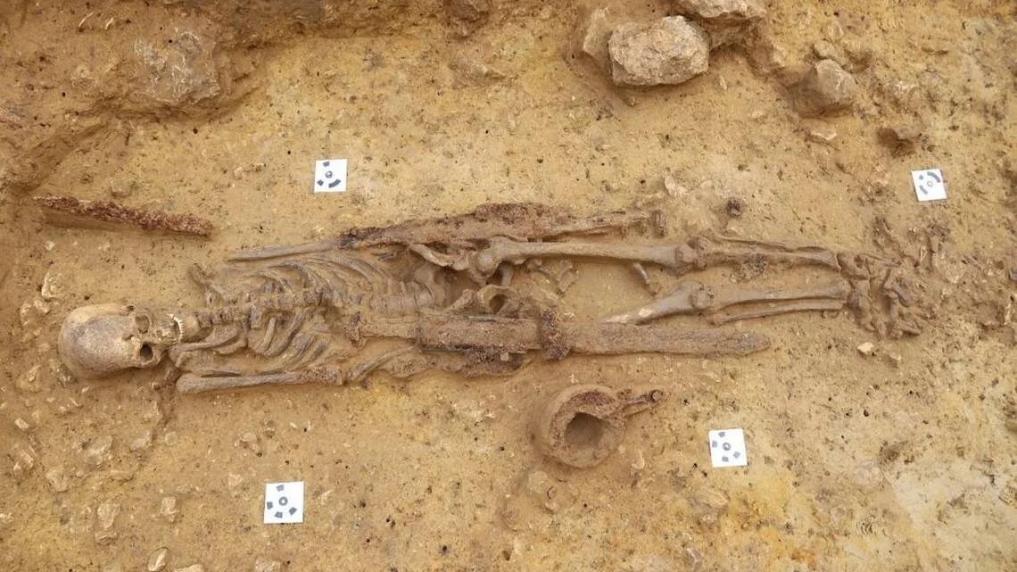
Archaeologists excavating an early medieval cemetery in Ingelheim found the untouched burial of a seventh century warrior, photos show. Photo from the City of Ingelheim and Christoph Bassler
However, the looters overlooked something, and archaeologists were determined not to make the same error twice.
According to an announcement made by the City of Ingelheim on August 4th, it was a round piece of metal jutting out of the ground that initially drew the attention of archaeologists in Ingelheim.
Bassler claimed that the metal fragment belonged to a shield. It is challenging to connect the artifact to a particular funeral because it was found between two graves that had been robbed.
So they carried on digging and discovered an undiscovered burial.
According to the press release, a warrior was buried in the 1,300-year-old burial. In the seventh century, a 30- to 40-year-old man was buried beside nearly every kind of weapon available at the period.
Archaeologists discovered a double-edged spatha sword that was nearly 3 feet long under his right arm. Probably his most valued possession was this sword. He carried a broad seax, a short, hefty sword intended for slicing, by his left arm. According to the statement, the burial also contained a belt, knife, lance, and bronze scabbard.
Images of the warrior's burial were posted on Facebook by Kaiserpfalz Ingelheim, or the Ingelheim Imperial Palace, on August 9.
The fighter was most likely a Frankish guy, according to the style of his shield and weapons, experts say. He was buried in a now-disintegrated casket, as evidenced by his skeletal position.
According to Britannica, the Franks "forcibly settled" what is currently southern Germany starting in the sixth century. They ruled Franconia, which encompassed Frankfurt, Stuttgart, and Munich, until an additional royal dynasty took over in the eighth century.

A close-up view of the warrior’s grave from the deceased’s left-hand side. Photo from Kaiserpfalz Ingelheim
Archaeologists claimed that the 1,300-year-old warrior was not a trained combatant. Standing armies did not exist in his time as they do today. Instead, he probably looked after his own gear and went into fight with his leader.
According to the announcement, his exact cause of death is unknown, however he could have passed away from a disease or an injury sustained in war. The latter cause of death would not be unexpected, according to archaeologists, who highlighted the violence-themed burial items.
According to local officials, the objects were taken out of the cemetery for cleaning and further investigation.
About 330 kilometers southwest of Berlin is Ingelheim, also referred to as Ingelheim am Rhein.

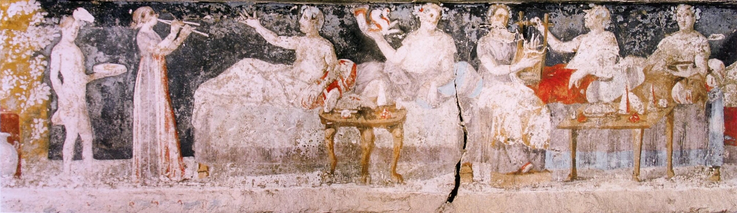
The Vibrant Panel from the Tomb of the Dancers: A Testament to Ancient Artistry and Cultural Exchange
At the heart of Ruvo di Puglia, an Italian town in the metropolitan city of Bari in Puglia, a discovery from circa 400–350 BC continues to dazzle the world with its vibrancy and evocative representation of ancient life and merriment. The famed panel from the Tomb of the Dancers provides not just an unparalleled glimpse into antiquity but also serves as a bridge connecting the artistic traditions of the ancient Greeks and Etruscans.
Delving Deeper into the Tomb of the Dancers
The Tomb of the Dancers is a paramount example of the cultural and artistic effervescence of the 4th century BC. The tomb is an underground chamber tomb, a type commonly associated with the Peucetians, an ancient Italic people. Its unique frescoes have illuminated our understanding of Italic funerary practices and beliefs, suggesting a synthesis of indigenous traditions and Hellenic influences.

The dancers, adorned in typical ancient attire, move harmoniously across the chamber walls, inviting speculation about their societal roles and the nature of the depicted ceremony. Intriguingly, the frescoes also showcase a series of birds, hinting at possible ornithological symbolism or beliefs in the soul's transcendence. The Tomb of the Dancers isn’t just a mausoleum; it's a narrative canvas, telling tales of an era where death, life, art, and spirituality wove together into a tapestry of shared human experience.
Colors of Antiquity
The first thing that captures an observer's attention when examining the panel is the sheer brilliance and preservation of its colors. Deep reds, yellows, and blues interspersed with earthy browns and gentle hues of white tell the story of an ancient palette that was both rich and varied. The hues have been extracted from nature—mineral pigments, plants, and other organic sources—reflecting the ancients’ profound understanding of natural resources.
Movement and Life
The name "Tomb of the Dancers" is no accident. The panel portrays a dynamic scene of dancers reveling in the throes of a celebration or perhaps a ritual. The way the figures are rendered, with limbs stretched out and garments flowing, gives a tangible sense of movement. You can almost hear the music to which these ancient figures danced.

Individuality and Expression
Unlike some ancient art, where figures can appear standardized or even stolid, the Tomb of the Dancers captures the essence of individuality. Each dancer possesses a unique posture, facial expression, and even hairstyle. This not only serves as a testament to the artist's acute observational skills but also offers insights into the diversity and individual expression cherished in ancient societies.
Greek Influences and the Evolution of Roman Artistry
The artistic style and motifs found in the Tomb of the Dancers have their roots in the Greek tradition. The ancient Greeks were pioneers in many art forms, from sculpture to painting, and they celebrated human form, movement, and emotion. This Greek aesthetic had a profound influence on the regions they interacted with, including the Italian peninsula.
The Hellenistic period, emerging after the conquests of Alexander the Great and lasting from the 4th to the 1st century BC, was characterized by a remarkable spread and fusion of Greek culture across the known world. Hellenistic paintings, in particular, broke from the idealism of the Classical era, opting for more emotional intensity, intricate details, and realism. These artworks depicted daily life, landscapes, and even still lives, revealing a broader spectrum of human experience. As the Roman Republic expanded and came into close contact with Hellenistic kingdoms, they were deeply influenced by this artistic evolution.
Banquet scene from the tomb of Agios Athanasios, Thessaloniki, 4th century BC.
Three main qualities unique to Hellenistic painting style were three-dimensional perspective, the use of light and shade to render form, and trompe-l'œil realism.
Roman frescoes, often found in the luxurious villas of Pompeii and Herculaneum, bore the marks of this Hellenistic inspiration. They adopted the rich color palettes, depth, and perspective techniques and were notably influenced by the genre scenes, landscapes, and portraiture of Hellenistic art. In essence, through their vast conquests and subsequent cultural assimilations, the Romans became the torchbearers of Hellenistic art, refining it and making it an integral part of their architectural and artistic narrative.
However, as the Etruscan and later Roman civilizations began to rise and assimilate various cultures and their artistic traditions, a synthesis occurred. While the Romans drew heavily from the Greeks, they added their own touch, emphasizing particular themes, subjects, and techniques. The frescoes in Roman villas and public buildings are classic examples of this blended tradition.
The fresco technique, where paint is applied on wet plaster, was employed by both Greeks and Romans, making it a shared tradition that spanned centuries and evolved stylistic nuances. The Tomb of the Dancers, while predating the zenith of Roman art, can be seen as part of this continuum, where the artistic baton passed from the Greeks to the Romans.
The vibrant panel from the Tomb of the Dancers stands as a monument to the artistry of ancient civilizations and their interconnected histories. It serves as a brilliant reminder that art is not just a reflection of the time in which it was created but also a window into the cultural exchanges, innovations, and shared human experiences of epochs past. The connections between Greek and Italic paintings and fresco history, exemplified in masterpieces like this, underline the intertwined nature of their civilizations and their lasting impact on the art world.
In Western New Mexico, researchers are using lidar to look for ancient pueblos
In an effort to better understand migration patterns and social interactions, archaeologists are currently searching Western New Mexico with lidar-equipped drones for the remains of ancient pueblos.

Data collected from drone-based lidar defines several rooms of an ancient pueblo, as well as a depression that researchers believe would have marked the location of a kiva inside.
"So what we're doing is mounting one of these lidar pods to a drone, flying it in a systematic way over the landscape, sending down a cone of laser images and measuring the bounce back of that light," explained Jeff Ferguson, an associate professor of anthropology at the University of Missouri.
The acronym "Lidar" stands for "light detection and ranging." Researchers are now able to observe things they couldn't before thanks to the data, which is then combined into a highly detailed rainbow-colored image that depicts the impressions of the ground where that light hit.
Ferguson claimed that due to the challenging topographical landscape, this area has historically received insufficient attention.

A top-down view of the newly surveyed pueblo thought to be built by immigrants in the 13th century.
It's about preserving the past, according to Ferguson. We could not even know what questions to ask about the past that might be significant if we aren't diligent.
The team recently conducted a reconnaissance of a sizable pueblo that was probably constructed in the late 13th century by immigrants from the Four Corners region.
They are working with another hands-off technology in addition to lidar that analyzes the chemical makeup of obsidian objects to determine their origin.
In Inner Mongolia, a Neolithic mussel shell dragon was discovered
In August 2023, archaeologists in Chifeng, in the Inner Mongolia Autonomous Region of North China, discovered a dragon made of mussel shells that is far older than the famous C-shaped jade dragon from the same Neolithic Hongshan Culture.
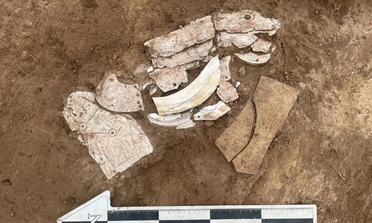
According to Song Jinshan, president of the Inner Mongolia Institute of Cultural Relics and Archaeology, the find is significant because it closes a gap in archaeologists' understanding of the dragon symbol in the early Hongshan Culture.
According to Hu Chunbo, the director of the excavation project at the Caitaopo Site in the Songshan district of Chifeng, the 20 centimeter-long dragon's head, body, and tail are assembled from a number of mussel shells like a jigsaw.
The uncovered artifacts, which were discovered next to two pottery ware fragments, are indicative of the Hongshan Culture.
In terms of carving methods and design, this mussel shell dragon differs significantly from the previously uncovered C-shaped jade dragon of the Hongshan Culture. The carving's teeth, tail, and other details are subtle, making it more delicate and realistic.
Furthermore, the shape is not a curled-body, C-shaped dragon but rather a spread-out representation of a dragon.
The previously found jade items from the Hongshan Culture, according to archaeologists, were placed at high-grade ceremonial structures or sites, whereas the dragon discovered during the current dig is a hint to the spiritual realm of people who lived in low-grade communities.
Northeast China's West Liao River Basin was home to the Neolithic Hongshan Culture. Hongshan sites, which date from roughly 4700 to 2900 BC, have been discovered in a region that stretches from the Inner Mongolia Autonomous Region to Liaoning. The carved jade produced by this civilisation is well-known.