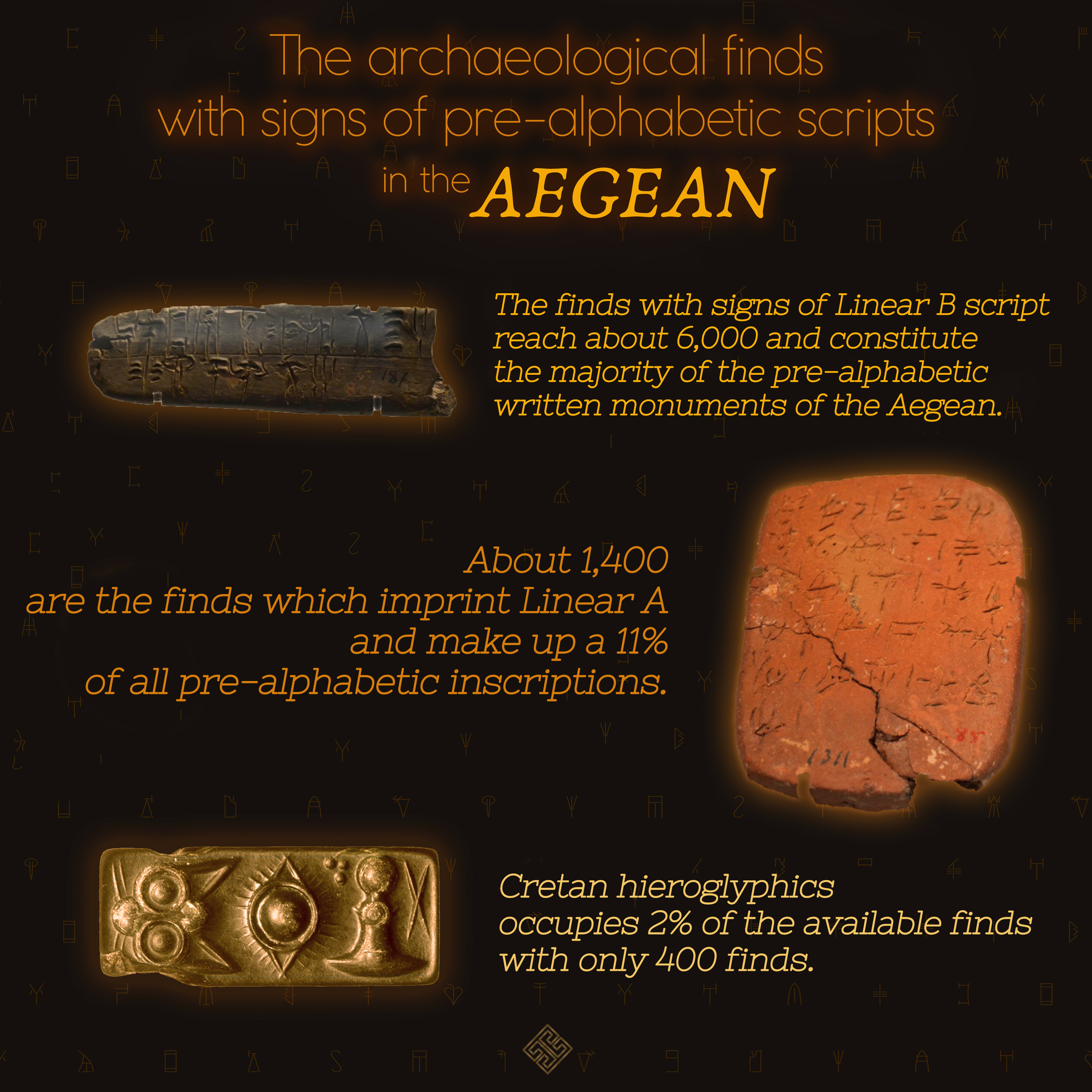
Forgotten South American Civilizations Before the Inca

Long before the Spanish Conquistadors embarked on their quest for the fabled riches of the Inca Empire in Peru, South America was a tapestry of civilizations that left behind a legacy of incredible cities, artistry, and enigmatic artifacts. Despite their profound contributions to the region's history, these ancient cultures often remain in the shadow of the Inca. In this article, we delve into the remarkable stories of five South American civilizations—the Chavin, Nazca, Moche, Tiwanaku, and Huari—whose legacies endure through the lens of archaeology and the echoes of myth.

1. The Enigmatic Chavin Civilization:

Around 1000 BCE, the Chavin civilization emerged in what is now Peru. Named after the archaeological site Chavín de Huántar, this culture remains shrouded in mystery. Little is known about their origin or political structure, as there is no evidence of a standing army or identifiable rulers. Central to their beliefs was the Lanzon, a spear-shaped deity, yet the intricacies of their religious practices are lost to time. Skilled artists and craftsmen, the Chavin created stunning pottery, textiles, and metalwork, which played a pivotal role in disseminating their cultural influence across the region. Around 200 BCE, the Chavin civilization began to wane, leaving behind its artistic legacy to shape the civilizations that followed.

2. The Nazca Lines: A Monumental Mystery

The Nazca civilization, which thrived around 200 BCE, left an indelible mark on the arid landscape of southern Peru. Known for the enigmatic Nazca Lines—massive geoglyphs etched into the desert floor—the Nazca are believed to have used these lines in their rituals and the distribution of water, a precious resource in their harsh environment. Dismissing extraterrestrial theories, researchers have determined that the Nazca created these intricate designs using simple tools and measurements. Their society comprised chiefdoms with a central religious power, notably at Cahuachi, where water management was of utmost importance. Human sacrifice and ancestor worship were central to their culture, as evidenced by trophy heads and intricate pottery. However, the Nazca civilization met its demise due to catastrophic El Niño weather events around 500 CE.

3. The Magnificent Moche Culture:

Contemporary with the Nazca, the Moche civilization occupied the northern coast of Peru, establishing themselves as a formidable power. At the heart of their civilization was the Huaca de La Luna, dedicated to the god of the mountains, Aiapaec. The Moche were known for their ritualistic practices, including human sacrifice and elaborate pottery that depicted real people in striking detail. Their architectural prowess, utilizing adobe, is exemplified by the monumental Huaca del Sol, although much of it was eroded during the Spanish conquest in search of gold. The fall of the Moche civilization can be attributed to the same El Niño events that affected the Nazca, leading to resource scarcity and internal conflicts.

4. The Prosperous Tiwanaku Culture:

Around Lake Titikaka, the Tiwanaku culture thrived from 550 CE to 950 CE, encompassing parts of Peru, Bolivia, and Chile. Renowned for their agricultural innovations and sophisticated architecture, the Tiwanaku people constructed monumental stonework, open ceremonial spaces, and intricate reliefs. Their civilization's deity, shared by several cultures, contributed to their lasting influence. An intriguing aspect of Tiwanaku culture was the diverse skull modification practices across their empire, reflecting regional or ethnic identities. Prolonged droughts around 1000 CE led to their agricultural systems' collapse, but their legacy persisted as the Inca adopted many of their achievements.

5. The Huari (Wari), Masters of Textiles and Empire:

The Huari culture, flourishing alongside the Tiwanaku, controlled extensive territories along the Peruvian coast and highlands. They imposed a centralized government, complete with a tax collection system and an intricate road network connecting regional cities to the capital, Huari. While their relationship with the Tiwanaku remains ambiguous, both cultures coexisted, refraining from large-scale warfare. Huari's artisans excelled in textiles, producing intricate tapestries with modern-like designs. The collapse of the Huari civilization can be attributed to droughts and internal conflicts. Smaller cultural groups absorbed their legacy into the Inca empire.

Before the Spanish Conquistadors' arrival in South America, a tapestry of civilizations thrived, each leaving behind a unique cultural footprint. From the enigmatic Chavin to the magnificent Moche and the prosperous Tiwanaku and Huari, these civilizations shaped the region's history, art, and architecture. Their stories, reconstructed through archaeology and myth, continue to captivate us, revealing the rich tapestry of South American history that lies beyond the shadow of the Inca Empire.

Exploring The Nazca Lines & Searching For Atlantis: The Lost City

Unlocking the Enigma of Peru's Nazca Lines: A 2,000-Year-Old Mystery

Nestled within the arid Peruvian coastal plain, approximately 250 miles south of Lima, lies a remarkable testament to ancient creativity and ingenuity—the Nazca Lines. These colossal geoglyphs, etched into the Earth's surface over 2,000 years ago, continue to captivate the imagination of researchers, historians, and adventurers alike. Despite more than 80 years of study, these enigmatic designs, consisting of straight lines, geometric shapes, and representations of various animals and plants, continue to baffle experts.

What are the Nazca lines?

The Nazca Lines can be broadly categorized into three distinct types: straight lines, geometric designs, and pictorial representations. The coastal plain boasts over 800 straight lines, some stretching up to an astonishing 30 miles in length. Among the geometric designs are triangles, rectangles, trapezoids, spirals, arrows, zig-zags, and wavy lines, showcasing the Nazca people's geometric prowess.

However, it's the pictorial representations that truly astound. More than 70 animals and plants have been meticulously etched into the ground, some spanning an incredible 1,200 feet in length. These include a spider, hummingbird, cactus plant, monkey, whale, llama, duck, flower, tree, lizard, and dog. Moreover, researchers have unearthed other intriguing forms, such as a humanoid figure affectionately known as "The Astronaut," as well as hands and several unidentifiable depictions.

Recent discoveries have only deepened the mystery. In 2011, a Japanese team uncovered a new geoglyph resembling a scene of decapitation, shrouded in smaller dimensions and harder to spot from aerial views. Notably, the Nazca people were known to collect "trophy heads," and research in 2009 revealed these trophies were often from the same populations as the individuals they were buried with, not outsiders.

Intriguingly, in 2016, the same team stumbled upon a 98-foot-long mythical creature with multiple legs and spotted markings, gleefully sticking out its tongue. This finding further underscores the cultural richness of the Nazca civilization. And in 2018, Peruvian archaeologists employed drone technology to uncover more than 50 previously unknown geoglyphs, providing unprecedented insights into the ancient Nazca culture.

How the Nazca Lines Were Created

Scholars posit that the Nazca culture, which emerged around 100 B.C. and thrived from A.D. 1 to 700, is primarily responsible for these magnificent creations. However, it's likely that the Chavin and Paracas cultures, predating the Nazca, may have contributed to some of the geoglyphs. The Nazca Lines occupy the desert plains of the Rio Grande de Nasca river basin, an archaeological site spanning over 75,000 hectares and renowned as one of the world's driest regions.

The desert floor is blanketed in a layer of iron oxide-coated pebbles, casting a deep rust-colored hue. To craft these designs, the ancient Nazca people meticulously removed the top 12 to 15 inches of rock, revealing the lighter-colored sand beneath. They likely began with small-scale models, carefully scaling up their proportions to create the grandiose designs that we marvel at today.

Interestingly, most known geoglyphs were formed by meticulously removing rocks from the borders of the figures, outlining their forms. Some, however, were created by removing rocks from within the designs. The Nazca Lines have endured remarkably well over time, largely untouched by rain, wind, or erosion.

Nazca Lines and Aliens?

The intrigue surrounding the Nazca Lines has, at times, been accompanied by speculations of extraterrestrial involvement. While the lines initially gained systematic study from Peruvian archaeologist Toribio Mejia Xesspe in 1926, they garnered international attention when pilots flew over them in the 1930s. This prompted a flurry of hypotheses regarding their purpose.

In the late 1930s and early 1940s, American historian Paul Kosok, studying the geoglyphs both from the ground and the air, proposed that they held an astronomical significance, particularly in relation to the winter solstice. Around the same time, German archaeologist María Reiche also suggested an astronomical and calendrical purpose for the designs, going so far as to equate some animal geoglyphs with constellations.

Nonetheless, the 1960s and 1970s witnessed a shift in perspective, with researchers like American astronomer Gerald Hawkins challenging the astronomical explanations. Claims of extraterrestrial involvement or ancient astronauts have also been debunked over the years, leading experts to reconsider other plausible purposes.

Purpose of the Nazca Lines

Recent research has unveiled compelling evidence suggesting that the Nazca Lines were linked to the quest for water—a precious resource in the parched Peruvian coastal plain. While they weren't designed as an irrigation system or a guide to water sources, they are believed to have played a central role in rain-inducing rituals meant to appease the gods. Some scholars point to the animal representations as symbols for rain, water, or fertility, noting their presence in other ancient Peruvian sites and on pottery.

This theory posits that the Nazca people viewed these geoglyphs as offerings to the heavens, beseeching for much-needed rain in their drought-prone region. In 2015, researchers attending the 80th annual meeting of the Society for American Archeology put forth an intriguing idea: the purpose of the Nazca Lines evolved over time. Initially, pilgrims traveling to Peruvian temple complexes used the geoglyphs as sacred processional routes. In later periods, as part of religious rites, groups would shatter ceramic pots at the intersection points of these lines.

Conservation Issues

Unlike many historical relics around the world, the Nazca Lines have been relatively sheltered from unintentional destruction, thanks to their remote location. Nevertheless, they are not immune to modern threats. In 2009, the Nazca Lines experienced their first recorded instance of rain damage when heavy downpours from the Pan-American Highway deposited sand and clay onto a section of the geoglyphs. Subsequently, in 2014, environmental group Greenpeace damaged an area near the hummingbird geoglyph during a misguided media stunt aimed at promoting renewable energy.

Their actions disturbed the upper layer of rocks surrounding the hummingbird. In 2018, another incident brought attention to the need for enhanced security and surveillance. A commercial truck driver drove onto a portion of the Nazca Lines, leaving deep scars in an area roughly 100 feet by 330 feet. This act of recklessness underscored the urgent necessity of safeguarding these ancient marvels for future generations.

The Nazca Lines continue to mystify and fascinate, serving as a testament to the ancient Nazca culture's ingenuity. While their exact purpose may remain elusive, ongoing research and discoveries offer new glimpses into the lives, beliefs, and practices of this remarkable civilization. To ensure the preservation of these ancient wonders, it is imperative that measures be taken to protect them from the unintended consequences of modern activities, thereby ensuring that the mystery of the Nazca Lines endures for generations to come.

The History of Peru Explained in 10 Minutes

Tracing the Storied Historical Journey of Peru

Peru, a South American gem with a population of 33 million, is steeped in a history that dates back several millennia. This country shares borders with Ecuador, Colombia, Brazil, Bolivia, and Chile and is home to the oldest known city in the Americas, Huaricanga.

At the dawn of history, Peru was a cradle of civilization. The Norte Chico civilization, noted for its development of cities and monuments without the benefit of pottery, thrived here. Unfortunately, the advancement in irrigation technologies might have precipitated their downfall. The innovative Kotosh period saw the inception of pottery for the first time as smaller settlements burgeoned into larger metropolises during the Chavin culture. This era was characterized by advances in metallurgy and agricultural technology, with the cultivation of potatoes, quinoa, and corn leading to a population explosion.

Remarkably, three centers of power—Lima, Moche, and Nazca—emerged to challenge the status quo. The city-state of Wari dominated the Peruvian coast, while Tiwanaku united the estranged city-states of the highland lakes. However, both empires declined swiftly around the year 1000.

Then came the era of the Inca. The city-state of Cuzco, founded by the Inca people, gradually expanded its territory while the city prospered. The Chanka, a neighboring tribe challenging Cuzco, was decisively defeated by Pachacuti, who subsequently ascended as the ninth Sapa Inca. His rule triggered a series of conquests transforming the kingdom into an empire, a vision diligently pursued by his successors, Túpac and Wayna Qhapaq.

The prosperous Inca empire was, however, battered by a strange disease brought by the Spanish conquistadors. The efficient Inca road system facilitated the rapid spread of diseases like smallpox, measles, typhus, influenza, and diphtheria. This biological blow was followed by the Ginástera civil war, lasting three years and further crippling the empire. The Spanish invader, Francisco Pizarro González, was the final nail in the coffin of the Inca empire.

The Spanish, thereafter, assumed control over the vast Inca territories. Despite a hefty ransom – a room full of gold and silver – paid in exchange for Atahualpa, the last Inca emperor, he was ruthlessly executed by Pizarro. The conquest took nearly forty years but once complete, it brought devastating consequences, with an estimated 95% of the Inca population perishing within a decade and a half due to armed conflicts and diseases. In their stead, the Spaniards established the Viceroyalty of Peru in 1542, with its capital in Lima. The discovery of silver in the mountain of Potosí was a financial boon for the Spanish Empire, as the city contributed over 60% of the world's silver production for over a century.

The history of Peru includes periods of rapid urban growth, rebellions, independence movements, wars, and internal conflicts. Following the decline of silver production, Peru’s prosperity dwindled. It was only after a war of independence, and a short-lived united state with Bolivia, that Peru emerged as an independent entity. Peru was embroiled in several wars and border conflicts during the 19th and 20th centuries and was even governed by a military junta during the Cold War era.

In recent years, however, Peru has seen a marked reduction in conflict, an improved economy, and enhanced living standards. Stability has also allowed for the growth of archaeology, giving us a richer understanding of pre-Inca civilizations. Modern Peru is taking steps to acknowledge its storied past, as evidenced by the documentary 'Lord of Sipan', which vividly portrays life in the Moche civilization.

The evolution of Peru's history makes it a rich tapestry of human civilization, and the country's journey from ancient states to vibrant modernity is a testament to the resilience of the Peruvian people. From the forward-thinking Norte Chico to the powerful Inca, and through the colonial Spanish era to its present independent status, the historical journey of Peru continues to captivate us all.

What happened when the Vikings met indigenous Americans?

"In this video, we explore the story of Leif Erikson and his journey to North America. As the son of the famous Norse explorer Erik the Red, Leif inherited a love of adventure and a desire to discover new lands. In the year 1000, he set out with a group of fellow Vikings on a journey that would lead them across the Atlantic and into the unknown.

The rope bridges of the Incas: The ancient technology that united Andean communities fades into history

A remarkable ancient technology and tradition that united communities in the Andes is fading into history.

Reconstruction of the Tinkuqchaka bridge is here almost complete.

Cirilo Vivanco

By LIDIO VALDEZ AND CIRILO VIVANCO

ONE EARLY JANUARY morning in the mid-1980s after a daylong journey from Ayacucho (formerly “Guamanga”), I (Lidio) found myself being guided across a small rope bridge hanging across the Pampas River. This was my first experience on such a bridge, made with an astonishing ancient technology that uses twisted branches to form a crossing. Although it looked to be only about 20 meters long, the bridge, called Chuschichaka, was beautiful: a reminder of ancient times, when similar bridges existed along trails and roads that linked the Inca Empire.

From the town of Chuschi, where I started my journey that day, my destination of Sarhua seemed to be just nearby. But because of the rugged landscape, the trip was long and exhausting: It took hours to hike the distance, with the rope bridge in the middle. At last, our team arrived in Sarhua and was welcomed by the community with food, drinks, music, and dance. Their hospitality made our visit an incredible and unforgettable experience.

My mission at that time as an archaeologist was to investigate ancient agricultural terraces in the region. As I prepared for my work, I was told that there was an important activity taking place that day: the reconstruction of a larger bridge nearby called Tinkuqchaka.

Except for a few older and younger people who were staying in the town, most community members were already on their way to the site of Tinkuy (a name that means “a place to meet,” “a place to play,” or “a place to fight”) to take part in bridge reconstruction. Sadly, I could not spare the time to attend, though I would hear all about such work later from my friend and colleague—anthropologist Cirilo Vivanco (co-author), who is originally from Sarhua.

When I left the community three days later in the early hours of the morning, Tinkuqchaka was not yet finished. We crossed the partially constructed bridge by flashlight, holding the handrails tightly.


THE ANCIENT PRACTICE of making hanging bridges has existed for a long time in Peru—perhaps going back as far as the Wari culture, which thrived from A.D. 600–1000. At one time, dozens of such bridges are thought to have connected communities across gorges and rivers. Today only a few remain, mainly for the sake of tourists, and even they are falling into disrepair. Just this April, the most famous of them—Queshuachaca, near the former Inca capital of Cuzco—collapsed from lack of maintenance.

The global appreciation of the hanging bridges of the Andes goes a long way back. In 1877, American archaeologist E. George Squier published Peru: Incidents of Travel and Exploration in the Land of the Incas, in which he devoted a few pages to the great hanging bridge over the Apurímac River on the main road to Cuzco. The bridge was built over a gigantic valley, enclosed by enormous and steep mountains. The over 40-meters-long structure, entirely made of plant materials, was hung from massive cliffs on both sides. To Squier, the bridge looked like a mere thread, a frail and swaying structure, yet frequently crossed by people and animals, the latter carrying loads on their backs. Travelers timed their day’s journey to reach the bridge in the early hours of the day before the strong winds came that made the bridge sway “like a gigantic hammock.”

This drawing from American archaeologist E. George Squier’s 1877 book on Peru shows a rope bridge over the Apurímac River.

E. George Squier/Wikimedia Commons

Squier was very impressed, saying that his crossing was an experience he “shall never forget.” His description and accompanying image of the bridge no doubt captured the imagination of everyone who got ahold of Peru: Incidents of Travel and Exploration in the Land of the Incas—including American explorer Hiram Bingham, famous for reporting the existence of the spectacular Inca city of Machu Picchu to a global audience in 1911. According to historians, one of the reasons Bingham decided to go to Peru in the first place was precisely the illustration of the Apurímac hanging bridge he saw in Squier’s book.

Long before Squier, Spaniards were impressed with the Inca hanging bridges too. Early Spaniards, such as Pedro de Cieza de León, were fascinated. But the arrival of the Spaniards had devastating effects for local Indigenous peoples. Europeans brought diseases that decimated the Indigenous populations. Communities were reduced or totally deserted. Spaniards’ interest in precious minerals, such as gold and silver, also switched the efforts of Indigenous peoples to other activities, often leaving unattended other communal obligations, such as building the bridges.

Tinkuqchaka was one of the few bridges to survive into the 2000s.

THREE YEARS AFTER my first trip to Sarhua, I was back again, this time on a mission to register the archaeological sites scattered around Sarhua along with Cirilo, as we recently published in the Journal of Anthropological Research. On our way, we crossed Tinkuqchaka again and bathed in the Pampas River below the bridge.

As we watched the bridge swaying delicately over the river, Cirilo told me about how Tinkuqchaka, being built entirely of plant material, required annual maintenance and a total renewal every two years. He told me, too, how the community, including himself, came together to do this. From my conversations with Cirilo, the story of this touching activity became clear to me.

Catherine Gilman/SAPIENS

Following ancient Andean ideals, the community of Sarhua is divided into two groups or ayllus. One of the ayllus is regarded as local while the other is said to be made up of “outsiders,” perhaps the descendants of peoples who were relocated by the Inca from elsewhere within the Inca realm. Both ayllus coexist side by side, and it is believed that such a division is necessary to maintain a balance needed for the well-being of the community. Sarhua residents do not usually highlight their group membership, except during communal activities like the bridge rebuilding.

One person, named by the community, is responsible for looking after the bridge. As in Incan times, the title of this person is chakakamayuq. Bridge renewal begins with a notification by the chakakamayuq to the community, which begins collecting the necessary construction material—the branches of a bush named pichus. Then, on a specified day, community members descend from Sarhua, carrying on their shoulders pichus branches to Tinkuy.

Kumumpampa, an open space found near the bridge, is the gathering place. At this location, both ayllus take their respective positions, the local ayllu closer to Sarhua and the ayllu of outsiders closer to the Pampas River, symbolically distant from Sarhua. After necessary logistical discussions, the ayllus exchange jokes and challenge each other, thus making the whole activity an entertainment or spectacle. For the participants, it is a competition between the two ayllus but also a game, time to play and time to tease and mock the opposition.

The task ahead for both ayllus is, first, to produce 23 ropes 100 meters long, called aqaras, from the pichus branches. Bundles of nine pichus branches are tied together and braided. The ayllu that produces more ropes will be declared the winner. Defeat is shameful, and thus both ayllus strategize to ensure victory. This is largely a male activity, but women of both ayllus are engaged by preparing meals and cheering for their respective side, mocking the men of the opposite ayllu.


Community members work hard to secure the heavy cables.

Cirilo Vivanco

Producing the aqaras is only the first challenge. The second task is to produce five thicker cables from the aqaras. This is a more difficult job. Starting at a middle point, teams from the ayllus build half of the cable working outward, again in competition. Experienced members are in charge, while younger members observe, fully aware that in the future it will be their turn. At the end, one of the ayllus emerges the winner and is celebrated with loud shouts. Victory is sweet and joyful, while defeat is ugly, painful, and agonizing.

Upon completing the five cables, work shifts to the edge of the river, on either side of which stands a stone tower. Members of the outsider ayllu cross to the opposite side of the river using the old bridge for one last time; then the old bridge is cut at both ends and is carried downstream by the Pampas River, thus marking the end of a cycle and reinforcing, temporarily, the separation of the outsiders.

The whole task of completing the bridge takes about five days.

The renewal of Tinkuqchaka illustrates the complementary role of the ayllus and their necessary reunion for the vitality of the community. Local ayllu members throw ropes to the opposite bank of the river, retaining one end in their hands. Since bridge construction takes place during the rainy season, when the river carries lots of water, this is not an easy task. The local ayllu ties the rope to the first thick cable so it can be pulled across the river. The cables are as thick as a person’s body, made of wet branches and heavy. It takes hours to pull the five cables across the river and tie each securely behind the stone tower on the far side.

Three cables, pulled taut and horizontal, become the base of the bridge over which small sticks are laid transversely and fastened to the cables by cords. Two smaller cables become the handrails.

The whole task of completing the bridge takes about five days, during which time the entire community remains at Tinkuy. While the days are spent working, evenings are time to socialize, drink, sing, and dance, and thus renew the sense of community. The community, aware of the historical significance of the bridge, is also proud of being responsible for carrying forward this tradition.


THE TECHNOLOGY EMPLOYED to build Tinkuqchaka appears to be ancient. The manner by which the bridge is built perhaps also resembles ancient customs. No one knows for sure. The fact that communities such as Sarhua are capable of undertaking such impressive construction and engineering feats shows the power of unified action.

There is the possibility that hanging bridges predate the Inca Empire. Large sections of the Inca royal highway already existed before the Incas, and along the same roads, there were several river crossings, thus suggesting that the bridge technology already existed. Demonstrating this possibility, of course, is not easy. There are no written records from this time, and the plant material of the bridges left no archaeological traces.

The hanging bridge constitutes an important symbol of the technology developed by the forebears of the Indigenous peoples of this region (including myself and Cirilo). In a perfect world, it would be rightfully considered a monument to the creativity and imagination of the Indigenous peoples of the Andes and maintained to showcase to the world this unique achievement of unknown origins.

The local and outsider ayllus gather on opposite sides of the river.

Cirilo Vivanco

Of course, there is no such perfect world, and decision-makers have other priorities. As Andean philosophy teaches, everything has an end. The hanging bridges are not an exception.

For the residents of Sarhua, a cable bridge was built in 1992 that effectively ended the biennial construction of the rope bridges. In 2007, a larger bridge that could carry cars was built. Tinkuqchaka was made anew in 2010 and reconstructed for the last time in 2014 for the sake of tourism. The local youth seem uninterested in renewing the tradition.

It appears we have come to witness the end of something wonderful, unique, and to foreign eyes, spectacular. Something that was present almost everywhere in this region is fading away forever, and some of us who had the fortune to see and walk on these bridges sometimes took them for granted, without realizing that within our lifetime an important chapter of Andean history was coming to an end.


Source: https://www.sapiens.org/archaeology/inca-r...