Roman Aqueducts: The Precision Surveying Behind the Pont du Gard
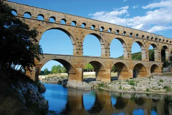
The Pont du Gard in southern France is more than just a picturesque bridge; it is a masterpiece of hydraulic engineering. Part of a 50-kilometer (31-mile) aqueduct system that supplied the city of Nemausus (Nîmes), it stands as a testament to the incredible precision of Roman surveying. To keep the water flowing by gravity alone, Roman engineers had to maintain a incredibly shallow gradient over rugged terrain.
1. The Challenge: A Gradient of Inches
The source of the water was the Fontaine d'Eure at Uzès, which sat only 12 meters higher than the delivery point in Nîmes.
The Math: Over the 50 km length of the aqueduct, this averages out to a gradient of only 24 centimeters per kilometer (about 1 inch every 400 feet).
The Pont du Gard Section: At the bridge itself, the precision is even more staggering. The water channel (specus) across the top of the bridge drops only 2.5 centimeters over its 275-meter length—a gradient of nearly 1 in 10,000.
2. The Surveyor’s Toolkit: Groma, Chorobates, and Dioptra
How did the Romans achieve such precision without modern lasers or GPS? They used three primary instruments to measure horizontal lines and vertical angles.
The Chorobates (The Level)
This was the most critical tool for aqueducts. It was a 20-foot-long wooden bench with a groove on top filled with water to act as a level. Plumb lines on the sides ensured the bench itself was perfectly horizontal.
Use: It allowed engineers to sight a perfectly level line across long distances, from which they could calculate the necessary "drop" for the next section.
The Groma (The Square)
The groma consisted of a vertical staff with a horizontal cross on top, from which four plumb lines hung.
Use: It was used to survey straight lines and right angles, ensuring the aqueduct followed a predictable path through the landscape.
The Dioptra (The Angle Finder)
A more advanced Greek-inspired tool, the dioptra used a sighting tube and cogwheels to measure both horizontal and vertical angles. It was particularly useful for tunneling through hills.
3. Structural Brilliance: The Three Tiers
The Pont du Gard had to cross the Gardon River valley. To maintain the gradient, the water had to stay at a height of 48 meters (160 feet) above the river.
Independent Arches: The bridge was built without mortar. The massive stones, some weighing up to six tonnes, were cut so precisely they stayed in place by gravity alone.
Maintenance Features: Protruding stones on the facade were left in place to support the scaffolding for future repairs, showing that the Romans designed for longevity and ease of maintenance.
The Specus (Water Channel): The interior of the channel was lined with opus signinum (a waterproof lime mortar mixed with crushed brick) and smoothed to minimize friction, ensuring the slow-moving water didn't stagnate or overflow.
4. The Castellum Divisorium: Urban Distribution
Once the water survived the journey over the Pont du Gard and reached Nîmes, it entered a circular distribution basin called a Castellum Divisorium.
Priority System: The basin featured lead pipes at different heights. The lowest pipes supplied the public fountains (the highest priority), while higher pipes supplied the public baths and eventually private villas.
The Siphon: In areas where the terrain was too deep for a bridge, the Romans used "inverted siphons"—lead pipes that used the pressure of the falling water to push it back up the opposite hill.