Introduction: The Grid of Empire
When Rome conquered new territories across Italy and the Mediterranean, its first act of dominance was not merely military occupation, but a radical geometric restructuring of the earth itself. This process was known as centuriation (centuriatio), a highly sophisticated system of land surveying that transformed chaotic wilderness, forests, and conquered fields into a rigid, uniform grid of square plots.
Managed by elite Roman military engineers called gromatici, centuriation served multiple vital functions for the expanding state. It was an instrument of agrarian economy, dividing land to be distributed to retiring military veterans as a form of pension. It was a tool of legal and fiscal administration, creating an indisputable map for property taxation. Most of all, it was a profound psychological statement of Roman order (disciplina) overcoming barbarian chaos. Today, more than two millennia later, this ancient grid remains permanently etched into the modern landscape, dictating the paths of contemporary roads, drainage canals, and property lines across Italy.
1. The Instruments of the Gromatici
The precision of the Roman grid was made possible by a specialized class of land surveyors who utilized a small toolkit of ingenious, low-tech engineering instruments.
The Groma: The definitive tool of the profession, from which the surveyors took their name (gromatici). The groma consisted of a vertical iron staff topped with a horizontal, cross-shaped bracket. From the four ends of the cross hung weighted plumb lines. By sighting across these parallel lines, the surveyor could project flawless, 90-degree right angles across long distances, establishing perfectly perpendicular straight lines on the horizon.
The Decempeda: A standard 10-foot (approx. 2.96 meters) wooden measuring rod, often tipped with iron. Surveyors used pairs of these rods, placing them end-over-end along the sighted lines to achieve precise linear measurements.
The Chorobates: A heavy wooden trestle level, roughly 20 feet long, featuring a water-filled groove along the top. This instrument was utilized alongside the groma when mapping out irrigation canals or sloping fields, ensuring the land grid accounted for proper water drainage.
2. The Surveying Coordinates: Creating the Axes
To lay out a new centuriation grid, the gromaticus began by establishing a central starting point, known as the umbilicus soli (the navel of the land). From this point, two primary, perpendicular master roads were laid out.
The Decumanus Maximus (DM): The primary east-west axis road. The surveyor typically oriented this line by tracing the path of the rising sun on the morning the survey commenced.
The Kardo Maximus (KM): The primary north-south axis road, constructed at an exact 90-degree angle to the Decumanus Maximus using the groma.
The Limitanei Roads: Running parallel to these two master axes at regular intervals were secondary roads and footpaths (limites), dividing the entire territory into a vast checkerboard.
3. The Math of the Century
The grid was calculated using standard Roman units of measurement, designed to break the landscape down into easily divisible agrarian units.
The Actus: The foundational unit of length, measuring 120 Roman feet (approx. 35.5 meters). This was traditionally considered the distance a team of oxen could plow before needing to stop and turn around.
The Jugerum: The standard unit of land area, defined as a rectangle measuring 2 actus long by 1 actus wide ($240 \times 120$ Roman feet). One jugerum represented the amount of land a single yoke of oxen could plow in a single day.
The Centuria (The Century): The ultimate building block of the Roman landscape. A century was a massive square measuring 24 actus on each side ($2,880 \times 2,880$ Roman feet, or roughly 710 meters). Each century contained exactly 200 jugera of land.
4. Veterans, Colony Distribution, and Taxes
Once the grid was established, the land was cataloged and distributed according to strict socio-political hierarchies.
Veteran Allocations: Upon retirement, a Roman legionary was typically awarded a plot of land within a newly centuriated colony. A standard private soldier might receive 1 to 2 jugera, while centurions and tribunes received significantly larger blocks, turning former soldiers into loyal, land-owning farmers who secured Rome's frontiers.
The Forma (The Bronze Map): Every centuriation survey was recorded onto two identical bronze tablets. One map was kept locally in the colony's archive, and the other was sent back to Rome for the imperial census. The forma explicitly marked which plots were assigned to veterans, which fields were left public, and which marshlands were uncultivable, preventing land fraud and guaranteeing accurate tax collection.
The Termini (Boundary Stones): At the intersections of the grid lines, surveyors buried heavy stone markers called termini. These stones were inscribed with precise coordinates detailing exactly how many centuries north, south, east, or west the marker stood from the central umbilicus, serving as a permanent, physical property ledger.
5. Architectural Alignment: Town and Country
The beauty of Roman centuriation lay in its structural continuity. The grid of the rural agricultural fields matched the urban grid of the colonial city perfectly.
The Urban-Rural Core: When a new Roman colony—such as Bologna (Bononia), Florence (Florentia), or Lucca—was founded, the city walls were oriented to the exact same Decumanus and Kardo axes as the surrounding farmland. The main streets of the city simply extended out through the city gates, transforming cleanly into the major agricultural highways of the countryside.
The Drainage Integration: Centuriation was an immense hydraulic engineering feat. The grid lines double-functioned as a massive network of drainage ditches, irrigation canals, and flood barriers. By sloping the grid along the natural topography measured by the chorobates, the Romans successfully drained vast, malaria-ridden marshlands across the Po Valley, turning useless swamps into the most fertile wheat fields in Europe.
6. The Indelible Fossil: Modern Survival
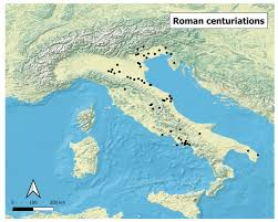
The ultimate testament to the engineering genius of the Roman gromatici is its sheer permanence. While the Roman Empire fell over 1,500 years ago, its geometric ghost remains clearly visible from space today.
The Padan Plain: In northern Italy, particularly in regions like Romagna, Veneto, and the environs of Padua and Cesena, the modern agricultural landscape is an almost flawless, unaltered preservation of the ancient 3rd-century BC Roman grid.
The Fossilized Infrastructure: High-resolution satellite imagery reveals that modern drainage ditches, farm boundaries, vineyard rows, and secondary country lanes still deviate exactly every 710 meters, tracing the precise lines walked by a Roman surveyor holding a groma two millennia ago. The ancient grid proved so efficient at managing water and allocating land that subsequent medieval, Renaissance, and modern societies simply chose to inherit the Roman framework rather than erase it, sealing the ancient map into the living tissue of modern Italy.