The city of Madaba, located along the ancient King’s Highway in modern-day Jordan, holds the undisputed title of the "City of Mosaics." During the Byzantine and Umayyad periods (4th–8th centuries CE), this region flourished as a wealthy agricultural and administrative hub, giving rise to a highly sophisticated school of master artisans who transformed the floors of churches, public buildings, and private villas into a sprawling sea of stone art.
The crown jewel of this artistic explosion is the Madaba Map—the oldest surviving geographic floor mosaic of the Holy Land in the world.
1. The Rediscovery of a Geographic Masterpiece
Like many ancient sites, the Madaba Map was preserved by catastrophe and uncovered by necessity. Following a series of devastating earthquakes in the 8th century, Madaba was completely abandoned, and its grand churches collapsed, sealing the mosaics beneath layers of protective dirt and debris.
The ruins remained untouched until 1880, when a group of Arab Christian families from Karak resettled the area. While clearing the rubble of a 6th-century Byzantine church in 1884 to construct the new Greek Orthodox Church of Saint George, builders smashed through a layer of ancient plaster and rediscovered the massive floor map.
While centuries of exposure and subsequent construction destroyed large portions of the original floor, a highly significant fragment measuring roughly 16 meters long by 5 meters wide survived completely intact.
2. Anatomy of the Map: The World in Tesserae
Dating to the mid-6th century CE (likely commissioned during the reign of Byzantine Emperor Justinian, c. 527–565 CE), the Madaba Map is a cartographic marvel composed of an estimated two million individual tesserae (small cubes of colored stone and glass).
The map represents a radical departure from standard Roman geometric floor patterns. Instead, it is a highly detailed, scaled, and labeled geographic atlas covering the entire Levant—stretching from Lebanon in the north to the Nile Delta in the south, and from the Mediterranean Sea in the west to the Eastern Desert.
Cartographic Orientation and Perspectives
East is Up: Unlike modern maps oriented to the North, the Madaba Map faces East. This layout aligns perfectly with the spiritual orientation of Christian churches of the era, pointing directly toward the altar and the direction of the rising sun.
The Bird’s-Eye View: The master artisans utilized an innovative dual perspective. While the broader landscape is laid out as a flat, two-dimensional map, individual cities, landmarks, and structural features are rendered in a three-dimensional, bird's-eye perspective, allowing viewers to see distinct gates, colonnaded streets, and roofs.
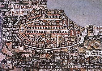
3. The City Plan of Jerusalem (Hierosolyma)
The absolute focal point and artistic climax of the entire mosaic is the remarkably detailed depiction of Jerusalem, positioned at the center of the map. This segment is so anatomically precise that it serves as an invaluable archaeological blueprint for 6th-century Byzantine urban planning.
The mosaic clearly highlights the defining features of the Holy City during its Byzantine golden age:
The Cardo Maximus: Running directly through the center of the oval-shaped city is a grand, colonnaded main thoroughfare, flanked on both sides by rows of pillars and covered markets.
The Damascus Gate: At the northern entrance of the city, a prominent semi-circular plaza features a single, isolated column—the historic milestone marker from which all distances in the province were measured.
The Church of the Holy Sepulchre: The architects meticulously positioned a large, triple-doored basilica with a distinct golden-orange conical dome, marking the traditional site of Christ’s crucifixion and burial.
4. Geographic Realism and Daily Life
Beyond its theological and political significance, the Madaba Map functions as a vivid documentary of the 6th-century natural environment and daily commerce:
The Dead Sea: Rendered in rich, dark blue stones, the Dead Sea features two large wooden merchant boats, with sailors actively rowing and managing rigging to transport salt, grain, and asphalt.
The Jordan River: The river is depicted flowing directly into the Dead Sea, filled with beautifully rendered fish swimming upstream. In a touch of artistic humor and geographic accuracy, the artisans depicted a fish turning around to swim away from the deadly, hypersaline water of the sea.
Fauna and Landscape: The wilderness areas are populated by native wildlife, including lions tracking gazelles across the plains of Moab, palm oases surrounding Jericho, and the lush agricultural fields of the Nile Delta.
5. The Madaba School of Mosaicists
The execution of the map demonstrates the sheer technical capability of the local Madaba workshops. Artisans utilized the Opus Tessellatum technique, employing local limestone, marble, and rare glass pastes to achieve a rich palette of over fourteen distinct colors, including deep reds, ochre yellows, vibrant blues, and pure whites.
The map features over 150 Greek inscriptions and captions, which function as a primitive geographic directory. The spelling, font style, and placement of these inscriptions perfectly mirror the Onomasticon of Eusebius, a 4th-century geographical treatise on biblical places, proving that the mosaicists were highly literate scholars working hand-in-hand with theologians and geographers.
The Madaba Map permanently altered the field of biblical archaeology. By providing a real-world, contemporary physical layout of 6th-century cities, the mosaic has allowed archaeologists to pinpoint, excavate, and successfully identify dozens of lost ancient sites across Jordan, Israel, and Egypt—proving that this ancient stone floor was never just a piece of religious art, but a highly functional, enduring scientific archive.