The Roman road network was a masterpiece of civil engineering, spanning over 250,000 miles at its peak. The secret to their legendary straightness lay in a simple but ingenious instrument: the Groma. This tool allowed Roman surveyors, known as Gromatici, to lay out perfectly straight lines and precise 90-degree angles across hundreds of miles of rugged terrain.
1. The Anatomy of a Groma
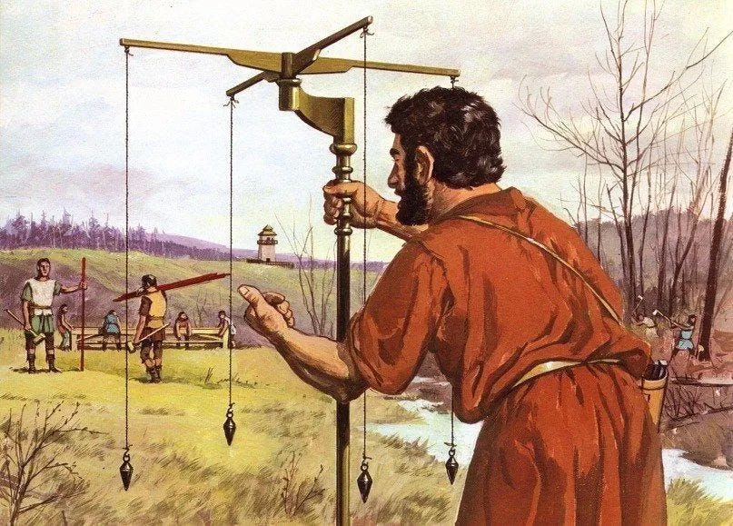
The Groma was a portable surveying instrument consisting of several key components designed for high-precision alignment.
The Ferramentum: A heavy iron-shod staff that was driven into the ground to provide a stable base.
The Rostrum: A horizontal swivel arm that extended from the top of the staff. This offset arm allowed the surveyor to look directly down the center of the instrument without the central pole blocking the line of sight.
The Stella (The Star): A horizontal cross with four arms of equal length, mounted on the rostrum.
Plumb Lines (Perpendicula): From each end of the four arms, a weighted plumb line hung down. These were the "sights" used to align the road.
2. Sighting a Straight Line
To lay out a road, the Gromaticus and his assistants would use a process of visual alignment that utilized the plumb lines as vertical guides.
Lining Up the Cords: The surveyor would stand at one end of the proposed route and look through two of the hanging plumb lines.
The Assistant's Role: An assistant would move a vertical pole (metae) in the distance until it was perfectly hidden behind the two hanging cords.
The Chain of Command: By repeating this process with a series of poles, the Romans could "project" a perfectly straight line over many miles, even through forests or across valleys.
3. Creating Perfect Right Angles
The primary function of the Groma’s cross-shape was the establishment of the Gromatic grid.
The Decumanus and Cardo: When planning a new city or military camp (castrum), the surveyor used the cross to mark two perpendicular lines. The east-west line was the decumanus, and the north-south line was the cardo.
The Grid System: Because the arms of the stella were fixed at 90 degrees, the surveyor could look through one pair of plumb lines for the first axis, then turn his head 90 degrees to look through the second pair, creating a perfect square grid for the town's streets.
4. Overcoming Obstacles: The Chorobates
While the Groma was perfect for horizontal alignment, it couldn't measure vertical slopes. For this, the Romans used the Chorobates, a 20-foot-long wooden level.
Water Channels: The top of the Chorobates featured a groove that was filled with water. If the water stayed level with the edges, the ground was flat.
The Result: This allowed the Romans to maintain a consistent "gradient" for their roads. This was vital because a road that was too steep would be impassable for heavy supply wagons, while a road with no slope would suffer from poor drainage and water damage.
5. Construction: The Layers of the Road
Once the Groma had marked the line, the construction crews (legionaries and laborers) dug a trench known as a fossa and filled it with four distinct layers.
Statumen: Large, heavy stones at the bottom for a solid foundation.
Rudus: A layer of crushed stone and lime to provide drainage.
Nucleus: A layer of fine gravel or sand mixed with hot lime to form a waterproof "concrete."
Pavimentum: The top surface made of large, flat polygonal stones, carefully fitted together and "cambered" (sloped) toward the sides so rainwater would run off into the ditches.
6. The Legacy of the "Straight Style"
The precision of the Groma was so effective that many modern European highways are built directly on top of the original Roman foundations. In cities like London, Florence, and Paris, the "Gromatic grid" laid out 2,000 years ago still dictates the flow of traffic. The instrument became a symbol of Roman order—proof that with a few strings, some lead weights, and a steady eye, they could impose a geometric "Old Style" of perfection onto the wild landscape of the ancient world.