"In this video, we explore the story of Leif Erikson and his journey to North America. As the son of the famous Norse explorer Erik the Red, Leif inherited a love of adventure and a desire to discover new lands. In the year 1000, he set out with a group of fellow Vikings on a journey that would lead them across the Atlantic and into the unknown.

10+1 Maya Pyramids Hidden in the Yucatan Tropical Rainforests
A sizable portion of the Maya civilization was located in the Yucatan Peninsula, modern-day Guatemala, Belize, parts of the Mexican states of Tabasco and Chiapas, the western part of Honduras, and El Salvador. Today, a large number of pyramid temples and other structures, including stelae, aqueducts, and enormous paved roads, are scattered throughout the lush tropical jungle, concealed by a particular mystique.
Nowadays, Mesoamerica can be found in a variety of architectural styles. The Mayas never established a single empire and lived in autonomous city-states. As a result, different regions have different temple traits and construction techniques. But among the various Mayan towns spread throughout Mesoamerica, one can clearly see a major architectural impact from the various pre-Hispanic civilizations. The Maya erected the majority of their pyramids as temples to their gods. Some of them have sanctuaries on their summits where people perform important rituals and ceremonies.

MUNDO MAYA
Map of the most important Maya archaeological sites
The Maya culture, which dates back 5,000 years, is still visible in the ruins they left behind. The still-standing buildings serve as a tangible reminder of their affluent way of life. The intriguing history of the Mayan temples, stelae, and pottery artifacts draws tourists from all over the world. In addition to being excellent architects, the Maya were also exceptional astrologers, agronomists, and mathematicians. They also invented a remarkable writing system (Mayan hieroglyphs) as well as an astonishingly precise calendrical cycle.
Main Maya Pyramids in Yucatan Peninsula
Tikal Pyramid Temples
One of the key Mayan sites, occupied from the 6th century B.C. to the 10th century A.D., is located in the middle of the jungle, surrounded by lush vegetation. The ceremonial center is home to magnificent temples, palaces, and ramp-accessible public areas. The surrounding area is littered with the remains of homes.
Numerous buildings, carved monuments, and other artifacts bearing witness to highly developed technical, intellectual, and artistic achievements have been found. These developments date from the first settlers' arrival (800 B.C.) to the last phases of historic occupation, which occurred around the year 900. Tikal has improved our knowledge of both a remarkable past civilization and more general cultural evolution. The Great Plaza, the Lost World Complex, and the Twin Pyramid Complexes, as well as ball courts and irrigation structures, are just a few notable locations that showcase the diversity and beauty of architectural and sculptural ensembles performing ceremonial, administrative, and residential roles.

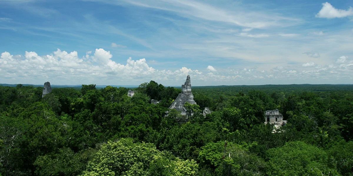
Tikal archaeological site from above.
After decades of archeological excavation, only a small portion of the thousands of ancient structures at Tikal have been excavated. The six enormous pyramids designated Temples I through VI, each of which supports a temple complex on its summit, are the most notable remaining structures. Some of these pyramids reach heights of more than 60 meters (200 feet). During the initial site survey, they were numbered in order. Each of these significant temples may have been constructed in as little as two years, according to estimates.
There are several significant pyramid temples at Tikal. Here's some information about a few of the most prominent ones:

Temple I: Also known as the Temple of the Great Jaguar, Temple I is a funerary pyramid dedicated to Jasaw Chan K'awiil, who was entombed in the structure in AD 734, the pyramid's construction having been completed for this event. This temple is approximately 47 meters high.
Temple II: Known as the Temple of the Mask, it was built around AD 700 and stands 38 meters high. Temple II is located on the west side of the Great Plaza, opposite Temple I, and it's believed that it's dedicated to the wife of Jasaw Chan K'awiil.
Temple III: The Temple of the Jaguar Priest, Temple III, stands 55 meters tall and was likely finished around AD 810. An elaborate roof comb once adorned this temple, though much of it has since collapsed.
Temple IV: The tallest pyramid in Tikal and the second tallest Maya structure in existence, Temple IV, or the Temple of the Double-Headed Serpent, stands at a whopping 70 meters tall. It was built around AD 741 by the ruler Yik'in Chan K'awiil.
Temple V: Temple V stands 57 meters high and was likely completed between AD 550 and 650. The identity of the person for whom it was built is currently unknown.
Temple VI: Also known as the Temple of the Inscriptions, it contains a lengthy hieroglyphic text important to the study of Maya history and is about 12 meters high.
Each of these temples has its own unique architectural and historical features, and all of them contribute to our understanding of the ancient Maya civilization.
2. El Mirador/La Danta

La Danta Pyramid
El Mirador is another significant ancient Maya archaeological site located in the northern Petén region of Guatemala, like Tikal. It's particularly well-known for its large structures, including the massive La Danta complex.
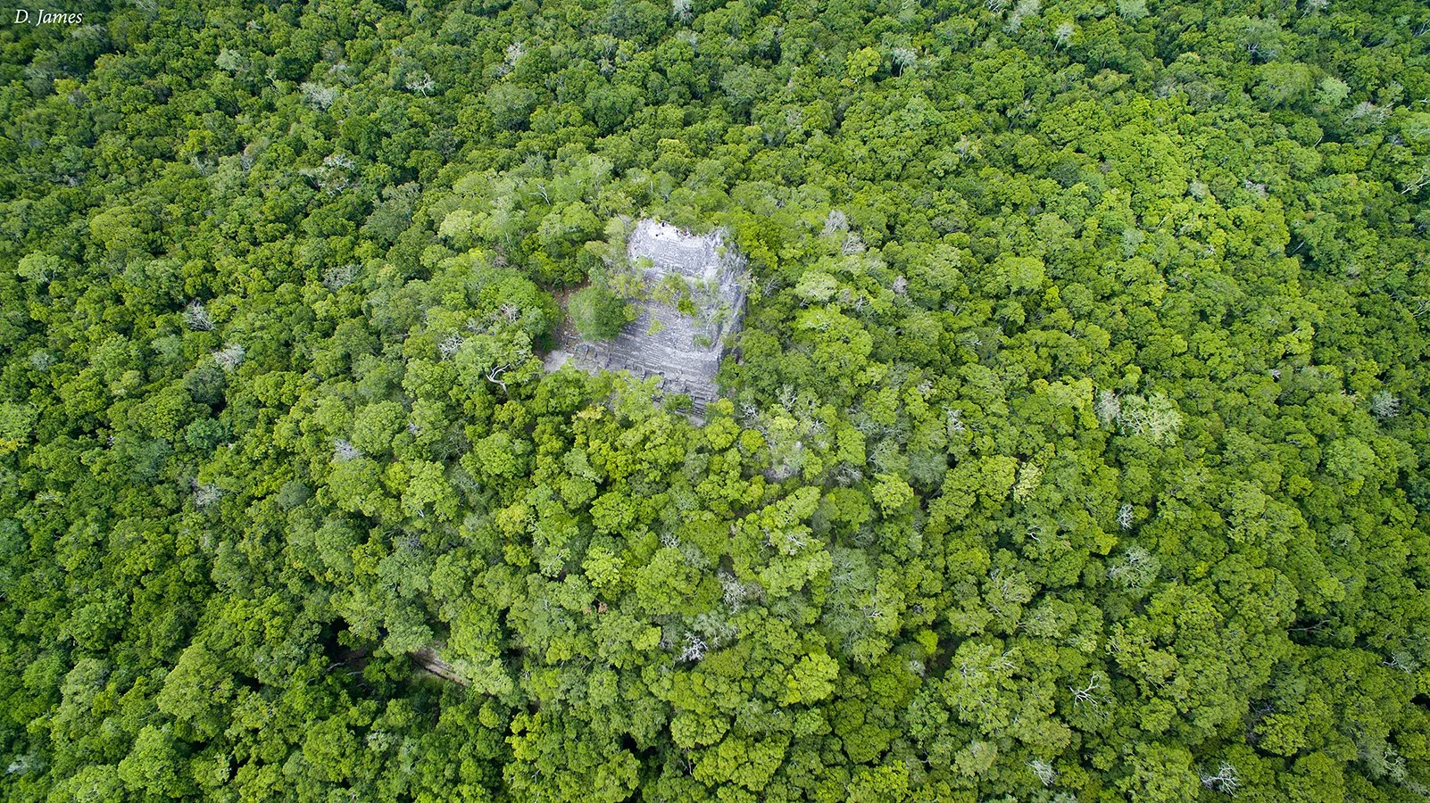
La Danta is one of the world's largest pyramids by volume, although it doesn't reach the heights of the Egyptian pyramids. La Danta measures approximately 72 meters (236 feet) high. However, because it's built on a platform that's already elevated, its top is some 230 meters (754 feet) above the level of the plaza.
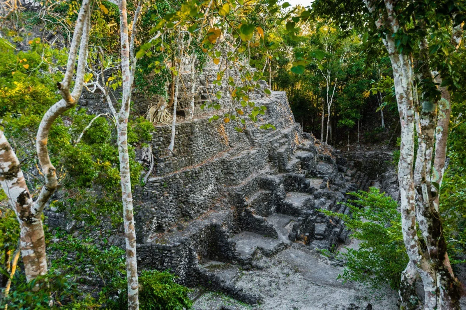
The base of the La Danta complex covers over 2.1 hectares (5.2 acres). When considering the total volume of the complex, including the underlying and adjacent platforms, it's one of the most massive ancient structures in the world. Some estimates put its total volume at over 2.8 million cubic meters.

Los monos complex
The structure of La Danta is made of cut stone, covered in stucco, and its platforms are supported by retaining walls of rock fill. The pyramid is part of a sprawling complex with multiple plazas, terraces, and smaller buildings. It's a typical example of the triadic style, popular in the Preclassic Maya period, which features a central structure flanked by two smaller inward-facing buildings, all mounted upon a single basal platform.

El Mirador flourished during the Late Preclassic period (around 300 BC to AD 100) and was one of the largest cities of ancient Maya civilization during this time. Although it had largely fallen into obscurity by the time of the Classic period (AD 250–900), when Tikal rose to prominence, it was a significant hub of culture, commerce, and local politics.

The site was rediscovered in 1926 and named El Mirador (The Lookout) because of its high altitude relative to the surrounding terrain. It's been the focus of extensive archaeological investigation, and efforts have been made to make the site more accessible for tourism. However, its remote jungle location makes access challenging, and it remains less well-known and less visited than some other Maya sites.
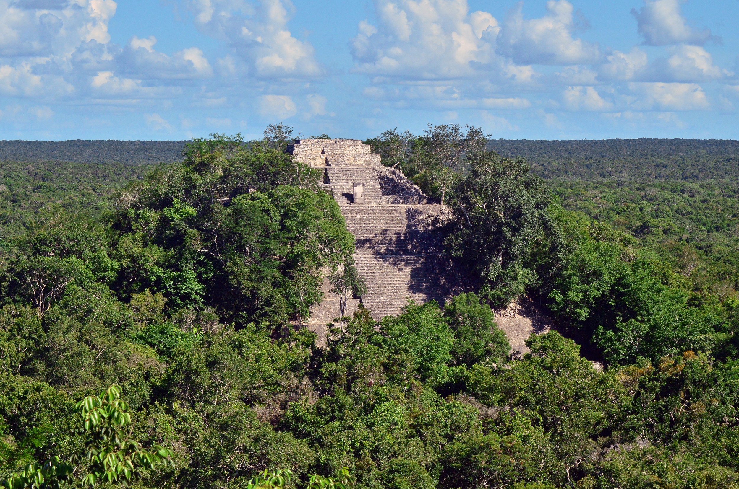
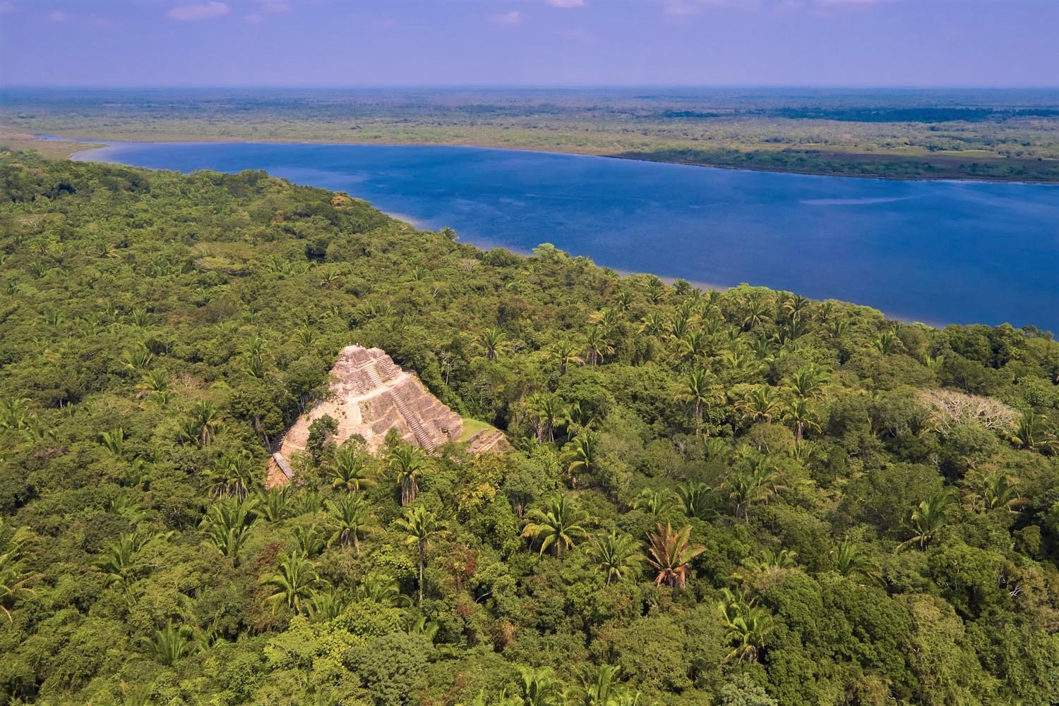
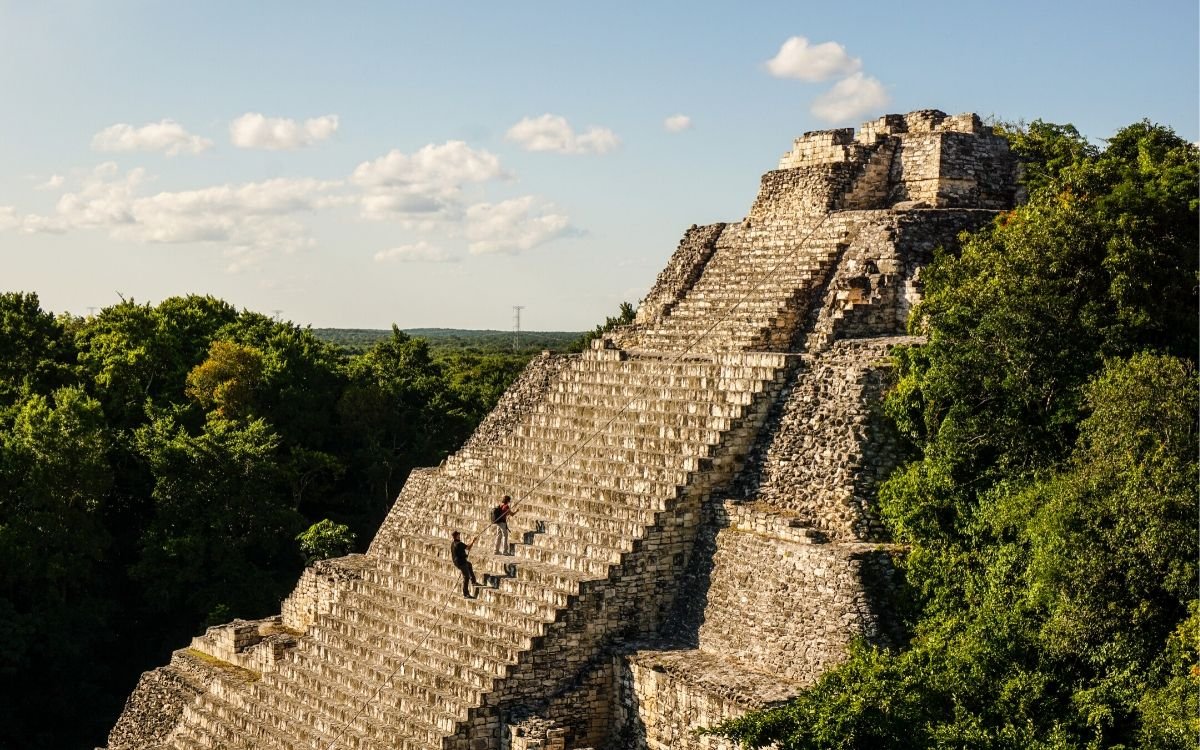
3. calakmul

Calakmul is another significant Maya archaeological site, located in the Mexican state of Campeche, deep in the jungles of the greater Petén Basin region. It is situated within the Calakmul Biosphere Reserve, close to the Guatemalan border. Calakmul was one of the largest and most powerful ancient cities in Maya history.

Structure II
Discovered under a late-period temple are some of the most stunning murals ever seen in the Maya world. There are at least eight Sacbe (white stone roads) that have been identified in the archeological zone.
The city was first established around 500 BC and reached its peak during the Classic Period of the Maya civilization, from AD 250 to 900. At its height, Calakmul is believed to have had a population of over 50,000 people, and its influence would have extended to many smaller nearby communities.
Calakmul was established atop a small natural plateau surrounded by a savannah, deep within the Calakmul Biosphere Reserve, and about 22 miles (35 kilometers) from the Guatemalan border. A system of canals and aguades supplied water. With a population of about 50,000 and over a million people under its political influence, it was one of the biggest and most powerful city-states in the Maya world.
Unlike many other Maya cities, Calakmul was never completely abandoned. While its political power waned at the end of the Classic period, it remained a place of activity and habitation up until the time of the Spanish conquest.
Here are a few key points about Calakmul:
Architecture and Layout

Calakmul is known for its great plaza and over 6,750 ancient structures, the largest of which is the great pyramid at the site, Structure 2. This pyramid is over 45 meters (148 feet) high, making it one of the tallest of the Maya pyramids. There are two tombs inside the pyramid with murals that are of great significance to Maya archaeologists.
The city is divided into roughly two halves by a series of reservoirs. The northern half appears to be the older part of the city, while the southern half, built later, is more grid-like in its layout.
Stelae and Monuments
Calakmul was a significant center of power, as evidenced by the large number of stelae found at the site. Stelae are large stone slabs, often carved with images and text. Calakmul has over 120 of these stelae, many of which portray the city's rulers and record their accomplishments.
The city of Calakmul is made up of a number of plaza groups centered on the Central/Grand Plaza and aligned with the four cardinal directions. These buildings are part of the Central Plaza Group: II, IV, V, VI, and VII. The enormous pyramid or temple known as Structure II at Calakmul is unquestionably the site's most magnificent building. It is located on the plaza's south side. It took many centuries and multiple expansions for this tower to reach its final height of about 150 feet (50 meters), making it the tallest and largest building in the Maya civilization. The diameter of its base is more than 400 feet (130 meters).
Structure VI, Structure VII, and Structure IV are all situated on the plaza's west, north, and east sides, respectively. The "E Group" is made up of structures IV and VI, which are assumed to have served as astronomical markers for the equinoxes and solstices.
Temple I
Structure Is a solitary structure that is situated south of the Central/Great Plaza. At a height of 130 feet, it is the second-highest pyramid in the area (40 meters). The pyramid is supported on a platform that extends 328 feet (100 meters) on each side.
The ball court lies to the north of Structure XIII. It is a 26-foot-tall, four-story, pyramid-shaped platform (8 meters). The platform foundation is 141 feet (43 meters). A two-story building is located atop the pyramid's peak and is reached by a central stairway. The edifice was built in the eighth century, according to a number of stelae that are present here.
The site of Calakmul was rediscovered in 1931, and archaeological work has been ongoing since the 1980s. In 2002, it was declared a UNESCO World Heritage Site, both for its cultural significance and because of its location within the protected Calakmul Biosphere Reserve.
Visiting Calakmul today involves a fairly lengthy trip into the jungle, but visitors are rewarded with impressive ruins and the rich biodiversity of the surrounding reserve.
4. Dzibanche - Kinichná

Kinichna acropolis
North of the Kohunlich ruins is a significant archaeological area called Dzibanche. The name, which in Yucatec Maya means "writing on wood," was given to a wooden support lintel covered in glyphs that was discovered in one of the temples. The site spans 7.7 square miles (20 square kilometers) in size, although the central region is significantly smaller and more accessible. 40 000 people are thought to have lived there at its peak population.
The site was occupied from around 200 BC to AD 900, flourishing during the Late Classic period (600–900 AD).

Xibalba plaza with temple of the owl (right) and temple of the cormorants (left).
The site features several plazas and a number of large temple pyramids. The most impressive among these is the Temple of the Captives, which gets its name from the various carved figures found in the temple that appear to be bound captives. Another significant structure is the Temple of the Lintels, which is named for its above-mentioned inscribed wooden lintels, an unusual feature in Maya architecture.
The site is home to four major groups that are dispersed over a vast area. Dzibanche, Kinichna, Tutil, and Lamay are the names of the groups. The Lamay Group can be viewed on the left side of the road on the approach to Dzibanche, although only Dzibanche and Kinichna are accessible to the general public. Causeways made of elevated white stone known as sacbeob connect these groups. The most significant municipal and ceremonial buildings at the site are found in Dzibanche.
The main building, known as the Temple of the Cormorants, is situated on the east side. Its Teotihuacan talud-tablero architecture makes it the tallest pyramid at the location. This edifice has several friezes attached to it. The base of this multi-tiered pyramid contains a masonry-built superstructure. The plaza level is reached by an outstanding central staircase that ascends to the summit temple. The multi-chambered temple's three entrances are divided between two pillars.

Kinichna acropolis
The Xibalba Plaza may be seen from the back of the Temple of the Cormorants, which is situated next to it. It can be reached by stairs on the building's northwest side. The focal point of this plaza complex is the Temple of the Owl, Structure I. It is a massive pyramid with Peten-style construction. A wide, central staircase ascends to a temple with numerous chambers. Via interior stairs, a tomb of a powerful woman from the late 5th century was discovered here.
Kinichna is located close to Dzibanche and is often visited in conjunction with it. Its most notable structure is a massive pyramid, believed to have been a royal residential complex. This pyramid, which visitors can climb, offers views over the surrounding jungle.
The name "Kinichna" means "House of the Sun" in Mayan. This site dates to the same period as Dzibanche, and there may have been close connections between the two cities.
The Kinichna Group is situated along a side road and behind the visitor center. The main building is a massive platform base with a three-level acropolis within it. It is a striking early classical building surrounded by trees in a tiny plaza with low platforms in front of it. There were two royal graves inside the building. A stucco Kin/Sun sign on the back of this building serves as the group's moniker. It was worth the quick drive.
The general public cannot access the Lamay group. Its main body is supported by a tall platform foundation. To the south of Dzibanche is where you'll find the Tutil Group. The Temple of the Paired Pilasters, the principal building, exemplifies peculiar Rio Bec-style architecture.
Archaeological excavation and restoration work at Dzibanche and Kinichna started in the late 20th century, and both sites have been opened to tourism. However, due to their remote locations in the dense jungle of Quintana Roo, they are less frequently visited than some of the more famous sites in Yucatan, such as Tulum or Chichen Itza. This can make a visit to Dzibanche and Kinichna a unique experience, offering a sense of the grandeur and mystery of the ancient Maya civilization without the crowds found at more accessible sites.
5. KOCHUNLICH

Kohunlich is a large archaeological site of the ancient Maya civilization, located in the Mexican state of Quintana Roo, in the Yucatán Peninsula. The city was first settled around 200 BC, but most of the buildings now visible were built in the Early Classic Period, from about AD 250 to 600.
The site was originally named by archaeologists after the nearby modern town of X-làabch'e'en, which means "old water" in the Maya language. The current name, Kohunlich, is a corruption of the English name "Cohoon Ridge," referring to the cohoon palm, a local tree species.
Kohunlich covers about 21 acres and surrounds a central plaza. The city's buildings were constructed from limestone, and many of them are quite well preserved. One of the most famous structures at the site is the Temple of the Masks, which gets its name from the large stucco masks that decorate its facade. These masks, each over 1.5 meters high, are remarkably well preserved, offering a unique insight into ancient Maya art and symbolism.

Other significant structures at Kohunlich include the Palace of the Stelae, the Plaza of the Acropolis, and the Plaza of the Stepped Pyramids. The city also has a number of residential buildings, showing that it was once a thriving urban center.
Kohunlich is particularly notable for its well-preserved residential area and its advanced system of urban design and water management. The city includes a number of large platforms that were once topped by residential buildings, indicating that it was home to a substantial population. The city's inhabitants also created an intricate system of channels and cisterns to control the flow of water and conserve it during the dry season.
Present Status: Kohunlich is relatively off the beaten path compared to more famous sites like Chichen Itza or Tulum, but it's a notable destination for those interested in Maya archaeology and history. The site is situated in a lush jungle setting, which adds to its appeal, and the preservation of its structures offers a vivid glimpse into the ancient Maya civilization.
The exact peak and decline periods of Kohunlich are still not definitively known, and the site continues to be an important focus of ongoing archaeological research.
6. COBA PYRAMIDS

Nohoch Mul Pyramid, Cobá
Coba is an ancient Mayan city located in Quintana Roo state on the Yucatán Peninsula in Mexico. It was a major urban center during the Classic Period of Mayan civilization, which spanned from about 250 to 900 AD. At its peak, Coba may have had a population of over 50,000 people.
Key structures and features in Coba:
Nohoch Mul Pyramid: This is the tallest pyramid in Coba and one of the tallest in the Yucatán Peninsula, standing at about 42 meters (137 feet) high. It is also known as the "Great Pyramid.". A steep 120-step climb to the top of Nohoch Mul provides an expansive view of the surrounding jungle. Unlike many ancient sites in Mexico, as of my knowledge, as of September 2021, visitors are still allowed to climb this pyramid. However, rules can change, so it's best to check the current situation before planning a visit.

xai'be pyramid
Other Structures: The city of Coba includes several large pyramid structures and a variety of other buildings. There's the Church (La Iglesia), the second-tallest structure in Coba; the Ball Court (Juego de Pelota), where Mayans used to play a ceremonial ball game; and the Paintings Group (Grupo de las Pinturas), named for the traces of colored murals found there. There's also a series of raised stone paths known as sacbeob (plural of sacbe) that connect the central areas of the city to outlying structures and nearby cities.
Sacbeob (White Roads): One of the distinctive features of Coba is its network of sacbeob, or "white roads.". These raised causeways were built of stone and covered in white plaster, and they connected the various parts of the city and linked Coba to other Mayan sites in the region. The longest sacbe in Coba extends over 100 kilometers (62 miles) to the site of Yaxuna. These sacbeobs are a testament to the engineering skills of the ancient Maya.
Stelae: Coba is known for its large stone slabs, known as stelae, which are carved with glyphs and images. These stelae were often used to commemorate significant events or the lives of important individuals.
In 1973, Cobá's archeological site was finally made accessible to the general public. Although there are thought to be 6,000 structures there, only three communities are accessible to the general public. Coba is not a single site like Chichen Itza, Ek Balam, or even Tulum; rather, it is a huge collection of monuments linked by more than 16 Mayan ceremonial "white roads" (sacbéob), all of which are related to the central pyramid.

Nohoch Mul Pyramid, Cobá
The group that is furthest away from the entryway is the Nohoch Group. The reason it is featured here first is because this group includes Ixmoja, the highest pyramid at Coba, which is around 138 feet (42 meters) tall. The highest pyramid in northern Yucatan is reached after a dizzying 112 stairs (others claim 130).
La Iglesia, or the Church, is the most significant of the buildings that have been unearthed and consolidated in the Acropolis. La Iglesia, Structure B-1, which has a height of over 72 feet (24 meters) and was constructed and added upon over several centuries beginning in the Early Classic, is the second tallest pyramid at the location. It has nine tiers and a tiny post-classic temple on top. It is located at the rear of Courtyard A, an open courtyard that faces west and overlooks the plaza and Lake Coba. Regrettably, climbing the pyramid is no longer possible.

Muuch'il Boonilo ob (Painting Complex) in Coba.
The Paintings Group, which is predominately Post-Classic (1100–1450 A.D.), includes East Coast-style buildings like those in Tulum, Mayapan, and Chichen Itza. It has many buildings, the greatest of which is the Temple of the Paintings, Structure 1, which is gathered around a single plaza. It is a pyramidal building on the east side of the plaza that is topped by a tiny temple that has remnants of painted paintings. It stands 26 feet (8 meters) tall. The temple has a single room with two entryways on the west side serving as its main access points. On the north and south sides, there are other single entryways that can be observed.
A sizable plaza that is a component of the D Group is located just beyond the Ball Court. Several sacbeobs enter and go from this area. The main building, called Xai'be, is located at the east end of the plaza and means "crossroads" in Yucatec Maya. This four-tiered, conical-shaped structure with two medial moldings has been tastefully repaired. On the west side of the building, there is a staircase. A covered stela is situated in front of the staircase. It is incorrect to call this building an observatory.
Today, Coba is a popular tourist destination. Its remote location and extensive ruins make it a great spot for those interested in Mayan history and culture. The site is surrounded by two large lagoons, and the city's ruins are interspersed with dense jungle, adding to its beauty. The site also has a visitor center, which offers more information about the city and its history.
Coba remains an active site for archaeological research, with many structures still partially unexcavated or undiscovered, leaving much about the site and its history to be learned.
7. cerros ruins

Cerros is a significant archaeological site associated with the ancient Maya civilization, located in northern Belize. Situated in Corozal Bay, it's notable for its pyramids, some of the earliest identified in the Maya world, which makes it a key site for understanding the transition from the Preclassic Period (2000 BC to AD 250) to the Classic Period (AD 250 to 900) of Maya history.
Historical Significance
Cerros was inhabited from about 400 BC to AD 400. The city reached its peak during the Late Preclassic Period, from around 50 BC to AD 150, during which time its population increased significantly and many of its most notable buildings were constructed.
This was a time of major social and political change in the Maya world. It is believed that a new religious ideology related to the worship of the Maya maize god was spreading throughout the region. The leaders of Cerros appear to have embraced this new ideology and used it to legitimize their authority, which is reflected in the city's architecture.
Main Structures
Cerros features several large pyramid temples, some of which are arranged around a central plaza. The largest of these is Structure 5C-2nd, which stands about 16 meters (52 feet) high. This pyramid is notable for its elaborate masks and other carvings, many of which represent aspects of Maya cosmology and the agricultural cycle.
Another significant structure at Cerros is the so-called "Temple of the Sacrificial Burial," which contains the tomb of a high-status individual. Many valuable artifacts were found in this tomb, including jade jewelry, ceramics, and shell inlays.
Decline and Abandonment
After about AD 150, the population of Cerros began to decline. By AD 400, the city had been largely abandoned. It's unclear why this happened, but it may have been due to a combination of political, economic, and environmental factors.
Today, Cerros is a popular tourist destination. Visitors can explore its ancient pyramids and plazas, learn about its history, and enjoy the beautiful surrounding landscape. The site also provides important insights into the early development of Maya civilization and the spread of new religious and political ideas during the Preclassic Period.
8. lamanai ruins
Lamanai is a significant archaeological site of the ancient Maya civilization located in Belize, Central America. The site lies along the banks of the New River Lagoon and was continuously occupied for over 3,000 years, from around 1500 BC to the 17th century AD, which is unusually long for a Mesoamerican site.
The name Lamanai comes from the Maya term "Lama'an/ayin," which translates to "submerged crocodile." Given that there are several crocodiles living in the surrounding tropical rainforest, this name is appropriate.

Here are some highlights of Lamanai:
High Temple (N10-43): Also known as the Temple of the Jaguar, this is the tallest structure at Lamanai, reaching a height of approximately 33 meters (108 feet). From the top, you can get a stunning view of the surrounding jungle and the New River Lagoon.
Mask Temple (N9-56): Named for the enormous 13-foot stone masks that adorn it, this temple is among the site's most famous structures. The masks are believed to represent ancient Maya rulers deified as gods.

The Mask temple
Jaguar Temple (N10–9): This temple is named for the boxy jaguar masks that decorate its base. These are the first known examples of Maya art to depict the jaguar, an animal that was considered sacred by the Maya and other Mesoamerican cultures.
Residential and Public Structures: Besides the temples, Lamanai also includes various residential structures, plazas, a ball court for playing the Maya ball game, and a few Christian artifacts, including the remnants of two Spanish churches and a sugar mill, evidencing Spanish colonial presence in the area.
The Stele: Lamanai is home to the second-longest known text in the country, inscribed on a giant slab of stone known as a stela. These inscriptions provide valuable information about the city's history.
Lamanai's remote jungle setting, combined with the impressive ruins and the opportunity to see a wide array of wildlife, make it a popular destination for tourists.

The Jaguar temple
Unlike some other Maya sites, much of Lamanai has yet to be uncovered, which makes it an important site for ongoing archaeological research. The site's long period of occupation provides an extended record of the evolution of Maya culture and society.
9. becan ruins
structure IX
Becán is an ancient Maya archaeological site located in the Mexican state of Campeche on the Yucatan Peninsula. The site was occupied from around 550 BC to AD 1200, but it reached its peak during the Late Classic period (AD 600–900). The name "Becán" is from the Yucatec Maya language and means "path of the serpent".
Site Layout and Architecture
Becán covers about 25 hectares and is surrounded by a moat, making it unique among Mayan sites. The moat is believed to have been both a defense mechanism and a symbol of Becán's political independence. Within the moat, the site is divided into several architecturally impressive complexes that include plazas, platforms, temples, and palaces.
The core of Becán consists of three main plazas, known as Plaza A, Plaza B, and Plaza C. Plaza B, the largest of the three, is surrounded by several impressive structures, including a large pyramid known as Structure IX (also referred to as Temple 9). This structure is about 32 meters (105 feet) tall and is one of the highest in the Rio Grande region.
Significant Features and Artifacts

structure VIII
One of the most significant structures at Becán is a tall pyramid temple known as Structure IX. This temple, which has been partially restored, is an excellent example of the Rio Bec architectural style, characterized by tall, narrow towers and elaborate façades.
Becán is also known for its stelae, carved stone monuments that were commonly erected in Maya cities. The stelae at Becán often depict the city's rulers and record significant events in their reigns.
Historical Importance and Modern Exploration
Becán was an important regional capital in the Rio Bec region during the Late Classic period. Its strategic location and defensive fortifications suggest that it was a significant political and military center.
Becán was first excavated by archaeologists in the 1930s, and significant research was conducted at the site in the 1970s. Despite these efforts, much of the site remains unexcavated, and there is still a lot to learn about its history and the people who lived there.
Today, Becán is a popular destination for tourists visiting the Yucatan Peninsula. Visitors can explore the site's impressive ruins, walk the ancient city's causeways, and climb to the top of Structure IX for a panoramic view of the surrounding jungle.
10. balakmu Ruins

main pyramid Str D5-5 south group
Balamku is an archaeological site of the Maya civilization located in the Mexican state of Campeche, on the Yucatan Peninsula. The name Balamku means "Jaguar Temple" in the Yucatec Maya language.
Balamku was occupied from around 300 BC to AD 1000, with its peak in the Late Classic Period (AD 600–900), like many other cities in the region.
Significant Structures
The site features several pyramid structures and plazas, the most famous being the "Temple of the Three Lintels.". However, Balamku's most significant feature is a well-preserved frieze discovered in 1990 in one of its buildings, named Structure I.
This frieze is one of the longest and best-preserved stucco friezes in the Maya world. It extends about 16.8 meters (55 feet) in length and stands about 1.9 meters (6.2 feet) tall. The frieze features a series of 20 complex figures depicting the Maya creation myth and the establishment of rulership, all of which are represented within the mouth of a giant monster, often interpreted as the entrance to the underworld.
Archaeological Importance
Balamku's well-preserved frieze provides important insights into Maya cosmology, mythology, and the ideology of kingship. It's considered a key piece of evidence for understanding the beliefs and rituals of the ancient Maya.
Despite the significance of the frieze, much of Balamku remains unexplored, and the site continues to be an area of interest for archaeologists studying the Maya civilization.
Today, Balamku is open to the public and offers visitors the chance to see its extraordinary frieze and other ruins firsthand. It's less visited than larger, more famous Maya sites like Chichen Itza or Tulum, offering a quieter, more secluded experience. Visitors should be aware that, due to its relative remoteness, facilities at Balamku are somewhat limited.
11. COPAN RUINS

Copán is one of the most significant archaeological sites of the ancient Maya civilization, located in western Honduras near the border with Guatemala. It was one of the most important cities of the Maya world, as well as one of the most beautiful, known for the intricacy of its art and the sophistication of its architecture and urban design.
Copán was occupied for more than two thousand years, from the Early Preclassic period (1500–900 BC) to the Postclassic period (AD 900–1500). The city reached its peak during the Classic period (AD 250–900), when it was the capital of a major Maya kingdom.
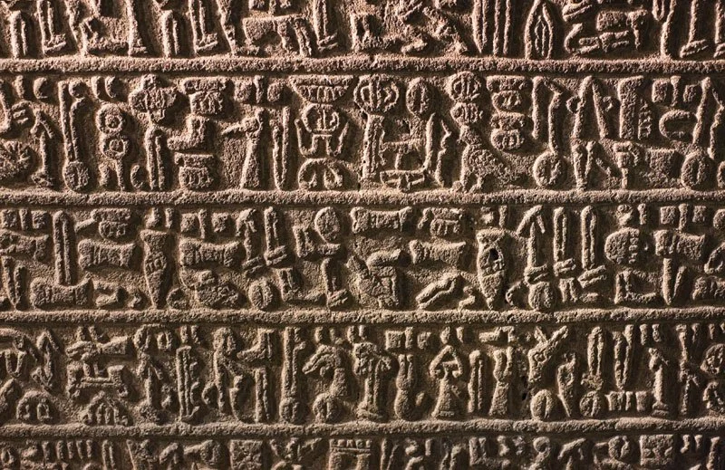
Hieroglyphic Stairway
One of the most impressive features of Copán is its hieroglyphic staircase, the longest text of ancient Maya hieroglyphic script ever discovered. The stairway is made up of thousands of individual glyphs, which together tell the dynastic history of the royal house of Copán.
Stelae

Temple 16
Copán is also known for its stelae—large stone slabs often covered with carvings and hieroglyphic text. The stelae at Copán are particularly noteworthy for their detailed and beautifully carved portraits of the city's rulers. Stela H, also known as the "Monument of the Moon," is one of the most famous of these, featuring a portrait of the 13th ruler of Copán, Waxaklajuun Ub'aah K'awiil.
Ball Court
The ball court at Copán is one of the largest and most impressive in the Maya world. The playing alley is flanked by sloping walls covered with intricate carvings, and the court is surrounded by a number of important buildings, including the Popol Nah (Council House).
Altar Q
This unique artifact is an important source of historical information about the site. The square-shaped altar is covered with the portraits of 16 rulers of Copán, depicted in chronological order.
Modern Exploration and Preservation
The ruins of Copán were rediscovered in the 19th century and have since been extensively studied and restored. The site is now a UNESCO World Heritage Site and one of the most popular tourist destinations in Honduras.
Despite extensive archaeological work, much of Copán remains unexcavated, and the site continues to be an important focus of ongoing research into the Maya civilization.

The History of Writing: Tracing the Development of expressing Language by Systems of Markings
Protowriting, ideographic systems, or early mnemonic symbols came before more advanced writing systems in the evolution of writing in human societies (symbols or letters that make remembering them easier).
A subsequent development is true writing, in which the content of a spoken language is encoded so that another reader may reasonably reconstruct the identical utterance written down. It differs from proto-writing, which frequently forgoes recording grammatical words and affixes, making it harder or even impossible to reassemble the precise meaning intended by the writer unless a substantial amount of context is already known in advance.
Writing innovations
The idea that writing originated in a single civilization and was called "monogenesis" persisted for a long time. According to academics, all writing originated in Mesopotamia's ancient Sumer and spread around the world as a result of cultural diffusion. This argument holds that traders or merchants traveling between geographical locations passed on the idea of representing language by written signs, though perhaps not necessarily the specifics of how such a system operated.

The finding of ancient Mesoamerican scripts, far from Middle Eastern sources, demonstrated, however, that writing had been created more than once. In at least four ancient civilizations, including Mesopotamia (between 3400 and 3100 BCE), Egypt (about 3250 BCE), China (1200 BCE), and lowland portions of southern Mexico and Guatemala, writing may have independently originated (by 500 BCE).
Some academics have suggested that ancient Egypt "The earliest authentic examples of Egyptian writing differ from Mesopotamian writing in both structure and style, indicating that they must have emerged independently. Although there is still a chance that Mesopotamian "stimulus dispersion" occurred, the influence could not have extended beyond the dissemination of an idea."
Because there is no evidence of communication between ancient China and the Near Eastern literate civilizations, as well as because Mesopotamian and Chinese approaches to phonetic representation differ, it is thought that ancient Chinese characters are independent creations.

The Vinča symbols.
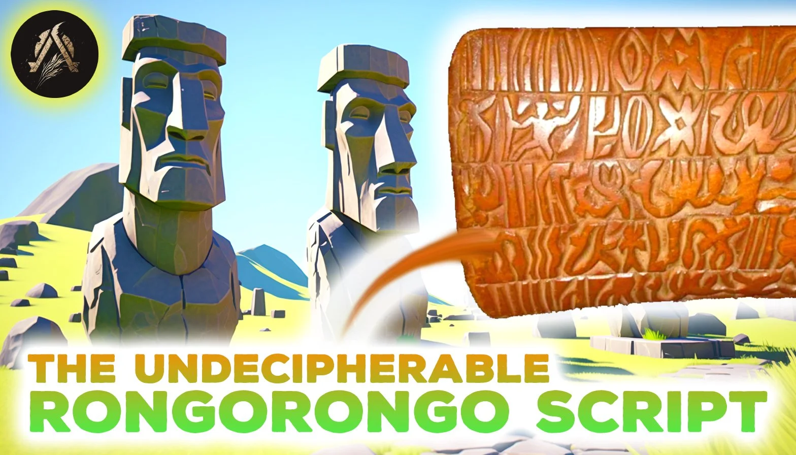
The Rongorongo script of Easter Island, the Vina symbols from about 5500 BCE, and the Indus script of the Bronze Age Indus Valley civilization are all controversial. Since none have been translated, it is unclear if they all represent real writing, protowriting, or something entirely different.
The earliest coherent texts date from around 2600 BCE, and Sumerian archaic (pre-cuneiform) writing and Egyptian hieroglyphs are usually regarded as the earliest authentic writing systems. Both developed out of their ancestors' proto-literate symbol systems between 3400 and 3100 BCE. The Proto-Elamite script belongs to roughly the same time frame.
writing methods
Writing systems are distinct from symbolic communication systems. For most writing systems, reading a text requires some knowledge of the spoken language that goes along with it. In contrast, it's not always necessary to have a prior understanding of a spoken language to use symbolic systems like information signs, paintings, maps, and mathematics. Every human group has its own language, which is thought by many to be a natural and essential aspect of mankind.
Writing system development has been intermittent, uneven, and delayed, and old oral communication systems have only been partially replaced. Writing systems generally develop more slowly after they are formed than their spoken counterparts and frequently preserve traits and idioms that have been lost to the spoken language.
Three writing standards are thought to apply to all writing systems. First, writing must be comprehensive; it must have a meaning or purpose, and it must make a point or be able to convey that message. Second, whether they are physical or digital, all writing systems must include some kind of symbol that can be created on a surface. In order to facilitate communication, the writing system's symbols must resemble spoken words or speech.
The greatest advantage of writing is that it gives society a way to regularly and thoroughly preserve information—something that the spoken word could not previously do as successfully. Writing enables communities to communicate knowledge, transmit information, and
stages of development

Sumer
An ancient civilization of southern Mesopotamia, is believed to be the place where written language was first invented around 3200 BCE.
Beginning with the Neolithic pottery phase, when clay tokens were used to keep track of particular quantities of animals or other goods, writing first appeared. These tokens were initially imprinted on the exterior of spherical clay envelopes, which were later used to keep them. Afterwards, flat tablets were gradually introduced in place of the tokens, and signs were recorded using a stylus. Towards the end of the fourth millennium BCE, Uruk was where actual writing was first discovered. Other areas of the Near East quickly followed.
The earliest recorded account of the development of writing is found in a poem from ancient Mesopotamia:
The Lord of Kulaba patted some clay and wrote on it like a tablet because the messenger's mouth was heavy and he couldn't repeat the message. It has never been possible to write on clay before.
Enmerkar and the King of Aratta, a Sumerian epic written around 1800 BCE
Although there is agreement among scholars as to the difference between prehistory and the history of early writing, there is disagreement as to when proto-writing became "real writing." The criteria are somewhat arbitrary. In the broadest sense, writing is a way of keeping track of information. It is made up of graphemes, which in turn can be made up of glyphs.
Many centuries of shattered inscriptions typically follow the advent of writing in a particular region. The presence of coherent texts in a culture's writing system is how historians determine a culture's "historicity".
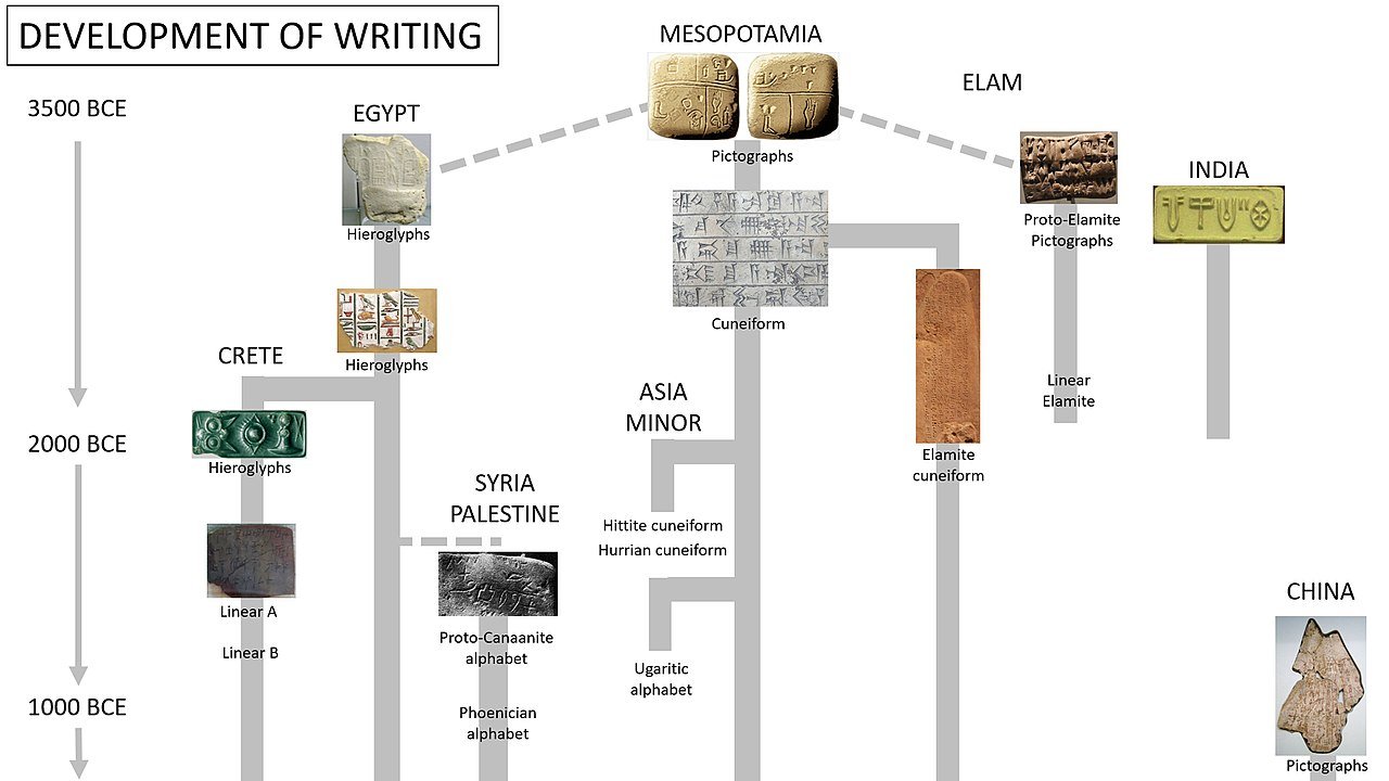
Standard reconstruction of the development of writing. There is a possibility that the Egyptian script was invented independently from the Mesopotamian script.
A conventional "proto-writing to true writing" system follows a general series of developmental stages:
Picture writing system: glyphs (simplified pictures) directly represent objects and concepts. In connection with this, the following substages may be distinguished:
Mnemonic: glyphs primarily as a reminder.
Pictographic: glyphs directly represent an object or a concept such as (A) chronological, (B) notices, (C) communications, (D) totems, titles, and names, (E) religious, (F) customs, (G) historical, and (H) biographical.
Ideographic: graphemes are abstract symbols that directly represent an idea or concept.

Pre-cuneiform tags, with drawing of goat or sheep and number (probably "10"): "Ten goats", Al-Hasakah, 3300–3100 BCE, Uruk culture.
Transitional system: graphemes refer not only to the object or idea that it represents but to its name as well.
Phonetic system: graphemes refer to sounds or spoken symbols, and the form of the grapheme is not related to its meanings. This resolves itself into the following substages:
Verbal: grapheme (logogram) represents a whole word.
Syllabic: grapheme represents a syllable.
Alphabetic: grapheme represents an elementary sound.

Designs on some of the labels or token from Abydos, carbon-dated to circa 3400–3200 BC and among the earliest form of writing in Egypt. They are remarkably similar to contemporary clay tags from Uruk, Mesopotamia.
The best known picture writing system of ideographic or early mnemonic symbols are:
Jiahu symbols, carved on tortoise shells in Jiahu, c. 6600 BCE
Vinča symbols (Tărtăria tablets), c. 5300 BCE[24]
Early Indus script, c. 3100 BCE
In the Old World, true writing systems developed from neolithic writing in the Early Bronze Age (4th millennium BC).
Locations and timeframes

Comparative evolution
from pictograms to abstract shapes, in Mesopotamian cuneiforms, Egyptian hieroglyphs and Chinese characters
Proto-writing
The first writing systems of the Early Bronze Age were not a sudden invention. Rather, they were a development based on earlier traditions of symbol systems that cannot be classified as proper writing, but have many of the characteristics of writing. These systems may be described as "proto-writing". They used ideographic or early mnemonic symbols to convey information, but it probably directly contained no natural language. These systems emerged in the early Neolithic period, as early as the 7th millennium BC, and include:
The Jiahu symbols found carved in tortoise shells in 24 Neolithic graves excavated at Jiahu, Henan province, northern China, with radiocarbon dates from the 7th millennium BCE. Most archaeologists consider these not directly linked to the earliest true writing.
Vinča symbols, sometimes called the "Danube script", are a set of symbols found on Neolithic era (6th to 5th millennia BCE) artifacts from the Vinča culture of Central Europe and Southeast Europe.
The Dispilio Tablet of the late 6th millennium may also be an example of proto-writing.
The Indus script, which from 3500 BCE to 1900 BCE was used for extremely short inscriptions.

The Dispilio Tablet
The Dispilio tablet is a wooden tablet bearing inscribed markings, unearthed during George Hourmouziadis's excavations of Dispilio in Greece, and carbon 14-dated to 5202 (± 123) BC.
It was discovered in 1993 in a Neolithic lakeshore settlement that occupied an artificial island near the modern village of Dispilio on Lake Kastoria in Kastoria, Western Macedonia, Greece.
Even after the Neolithic, a number of societies used proto-writing as a transitional form before adopting formal writing. Such a mechanism might have existed in the quipu of the Incas (15th century CE), often known as "talking knots". Another example is the pictographs created by Uyaquk before the Central Alaskan Yup'ik language developed the Yugtun syllabary around 1900.
Ancient writing
The Bronze Age saw the development of writing in a wide range of cultures. Indus script, Egyptian hieroglyphs, Cretan hieroglyphs, Chinese logographs, Sumerian cuneiform writing, and the Olmec script of Mesoamerica are a few examples. Around 1600 BCE, the Chinese script most likely evolved apart from the Middle Eastern scripts. It is also generally accepted that the pre-Columbian Mesoamerican writing systems, which include the Olmec and Maya scripts, had separate origins. In 2000 BCE, it is believed that the first real alphabetic writing was created for Hebrew laborers in the Sinai by assigning Semitic values to mostly Egyptian hieratic characters (see History of the alphabet and Proto-Sinaitic alphabet).
Ethiopia's Geez writing system is regarded as Semitic. With roots in the Meroitic Sudanese ideogram system, it is most likely of semi-independent origin. The majority of alphabets used today are either direct descendants of this one invention, many through the Phoenician alphabet, or were designed in direct response to it. The early Old Italic alphabet and Plautus (c. 750–250 BCE) were separated by around 500 years in Italy, while the Elder Futhark inscriptions and early works like the Abrogans (c. 200–750 CE) are separated by a similar amount of time in the case of the Germanic peoples.
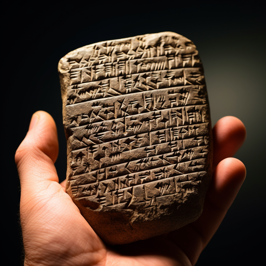
Cuneiform writing

The first Sumerian script was derived from a system of clay tokens used to denote different types of goods. This had developed into a system of keeping accounts by the end of the fourth millennium BC, utilizing a stylus with a circular form that was impressed into soft clay at various angles to record numbers. A pointed stylus was used to gradually add pictographic lettering on this to show what was being counted. Writing using a wedge-shaped stylus (hence the name "cuneiform") began to include phonetic features by the 29th century BCE and gradually replaced writing with a round stylus and a sharp stylus by about 2700–2500 BCE.
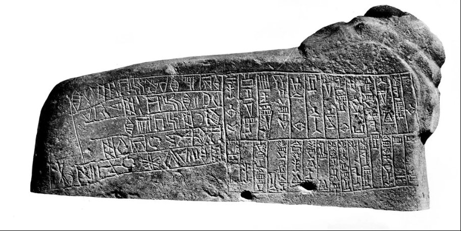
Cuneiform first started to represent Sumerian syllables around 2600 BCE. Ultimately, cuneiform writing evolved into a general-purpose system for writing numerals, syllables, and logograms. This alphabet was adapted to the Akkadian language starting in the 26th century BCE, and from there to others like Hurrian and Hittite. This writing system resembles Old Persian and Ugaritic scripts in appearance.
Hieroglyphics from Egypt
Literacy was concentrated among a well-educated elite of scribes, who played a crucial role in upholding the Egyptian empire through writing. To become scribes in the employ of temple, royal (pharaonic), and military authority, one had to come from a certain background.
According to Geoffrey Sampson, the general concept of expressing words from a language in writing was likely transmitted to Egypt via Sumerian Mesopotamia. Egyptian hieroglyphs "came into being a little after Sumerian script, and, possibly [were], invented under the influence of the latter." Despite the significance of early Egypt-Mesopotamia links, "no definitive judgment has been established as to the genesis of hieroglyphics in ancient Egypt" due to the lack of direct evidence. However, it is stated and agreed upon that "a very compelling argument can also be made for the independent development of writing in Egypt" and that "the evidence for such direct influence remains fragile."

Egyptian writing does suddenly appear at that time, but Mesopotamia has an evolutionary history of sign usage in tokens dating back to around 8000 BCE. Since the 1990s, discoveries of glyphs at Abydos, dated to between 3400 and 3200 BCE, may challenge the conventional idea that the Mesopotamian symbol system predates the Egyptian one. These glyphs were discovered in tomb U-J at Abydos; they were written on ivory and most likely served as labels for other items discovered there.

Even though he acknowledged that Egypt's geographic location made it a receptacle for many influences, Egyptian scholar Gamal Mokhtar maintained that the inventory of hieroglyphic symbols originated from "fauna and flora used in the signs [which] are essentially African" and that in regards to writing, "we have seen that a purely Nilotic, therefore African origin not only is not excluded, but probably reflects the reality."
Elamite writing
The unintelligible Proto-Elamite writing first appears around 3100 BCE. Around the latter third millennium, it is thought to have evolved into Linear Elamite, which was later supplanted by Elamite Cuneiform, which was adapted from Akkadian.
Indus script

Most inscriptions containing these symbols are extremely short, making it difficult to judge whether or not these symbols constituted a writing system used to record the as yet unidentified language(s) of the Indus Valley civilisation.
The Indus script has been assigned to markings and symbols discovered at numerous Indus Valley civilization sites due to the hypothesis that they were used to transcribe the Harappan language. It is disputed whether the script, which was in use from roughly 3500 to 1900 BCE, is a Bronze Age writing script (logographic-syllabic) or merely proto-writing symbols. According to analysis, it was written in boustrophedon or from right to left.

early SEMITIC ALPHABETS
Around 1800 BCE in Ancient Egypt, the first "abjads," which mapped individual symbols to individual phonemes but not necessarily each phoneme to a symbol, appeared as a representation of the language created there by Semitic workers. However, by that time, alphabetic principles had only a remote chance of being ingrained into Egyptian hieroglyphs for upwards of a millennium.
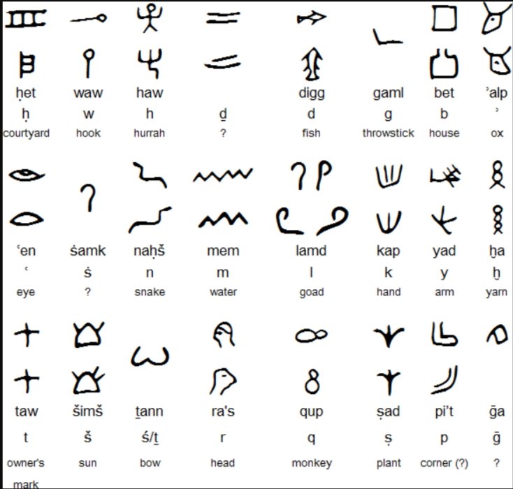
Did the Proto-Canaanite alphabet take its symbols independently of the hieroglyphs?
It is only until the end of the Bronze Age that the Proto-Sinaitic script separates into the Proto-Canaanite alphabet (c. 1400 BCE), Byblos syllabary, and the South Arabian alphabet (c. 1200 BCE). These early abjads remained of minor significance for several decades. The untranslated Byblos syllabary most likely had some influence on the Proto-Canaanite, which in turn provided inspiration for the Ugaritic alphabet (c. 1300 BCE).
Anatolian hieroglyphs
The Luwian language was written down using Anatolian hieroglyphs, a native hieroglyphic script found in western Anatolia. Around the fourteenth century BCE, it initially appeared on royal seals of the Luwians.
Chinese characters
The corpus of inscriptions on oracle bones and brass from the late Shang dynasty is the earliest authenticated example of the Chinese script that has been found so far. The oldest of these is believed to date from about 1200 BCE.
There have been recent finds of tortoise-shell carvings from around 6000 BCE, such as Jiahu Script and Banpo Script, but it is debatable whether or not the carvings are complex enough to be considered writing. 3,172 cliff carvings from the period between 6000 and 5000 BCE have been found near Damaidi in the Ningxia Hui Autonomous Region. They contain 8,453 different characters, including images of the sun, moon, stars, gods, and scenes of grazing or hunting.

Replica
of ancient Chinese script on an oracle turtle shell
These pictographs are thought to resemble the first Chinese characters that have been confirmed to be written. Writing in China would predate Mesopotamian cuneiform, traditionally recognized as the first manifestation of writing, by about 2,000 years if it were to be considered a written language. However, it is more likely that the inscriptions represent a type of proto-writing, comparable to the modern European Vinca script.
Early Greek and Cretan scripts
Cretan relics include hieroglyphic writing (early-to-mid-2nd millennium BCE, MM I to MM III, overlapping with Linear A from MM IIA at the earliest). The Mycenaean Greek writing system, Linear B, has been decoded, but Linear A has not yet been. The three overlapping, but distinct, Aegean pre-alphabetic writing systems can be categorized according to their chronological order and geographic distribution as follows:
Cretan Hieroglyphic / Crete (eastward from the Knossos-Phaistos axis) / c. 2100−1700 BCE
Linear A / Crete (except extreme southwest), Aegean Islands (Kea, Kythera, Melos, Thera), Greek mainland (Laconia) and west Minor Asia (Miletus and maybe Troy) / c. 1800−1450 BCE
Linear B / Crete (Knossos), and mainland (Pylos, Mycenae, Thebes, Tiryns) / c. 1450−1200 BCE

The archaeological finds with signs of pre-alphabetic scripts in the Aegean
(Up) The finds with signs of Linear B script reach about 6,000 and constitute the majority of the pre-alphabetic written monuments of the Aegean.
(Middle) About 1,400 are the finds which imprint Linear A and make up a 11% of all pre-alphabetic inscriptions.
(Down) Cretan hieroglyphics occupies 2% of the available finds with only 400 finds.
Illustration: Dimosthenis Vasiloudis
Mesoamerica
The Cascajal Block, a stone slab with 3,000-year-old writing that predates the first Zapotec writing from around 500 BCE, was found in the Mexican state of Veracruz. It is an example of the oldest script in the Western Hemisphere.

Stela 12 and 13
from the southern end of Building L, in the Zapotec city of Monte Albán, Outside of Oaxaca, Mexico.
The Maya script is one of numerous pre-Columbian scripts found in Mesoamerica, and it appears to have been the most well-developed and extensively deciphered. The earliest clearly identifiable Maya inscriptions date to the third century BCE, and writing continued to be used until just before the arrival of the Spanish conquistadors in the sixteenth century BCE. A combination of logograms and syllabic symbols, utilized in Maya writing, is somewhat reminiscent of current Japanese writing.

IRON AGE WRITING
The Proto-Canaanite alphabet, which was used into the Iron Age, is all that the Phoenician alphabet is (conventionally taken from a cut-off date of 1050 BCE). The Greek and Aramaic alphabets were derived from this alphabet. They eventually gave rise to the writing systems that are currently used everywhere, from Western Asia to Africa and Europe. The Greek alphabet, on the other hand, was the first to use specific symbols to represent vowel sounds.

By Matt Baker
In the first centuries of the Common Era, the Greek and Latin alphabets gave rise to a number of European scripts, including the Runes, Gothic, and Cyrillic alphabets, while the Aramaic alphabet developed into the Hebrew, Arabic, and Syriac abjads, the latter of which spread as far as Mongolian script. The Ge'ez abugida originated from the South Arabian alphabet. According to some academics, the Indian Brahmic family also descended from the Aramaic alphabet.
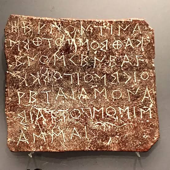
GRAKLIANI HILL WRITING
At Georgia's Grakliani Hill, behind a fallen altar from a temple dedicated to a fertility goddess from the seventh century BCE, an obscure script was uncovered in 2015. Grakliani's other temples' inscriptions, which depict animals, people, or decorative features, are different from these ones. Although its letters are rumored to be connected to ancient Greek and Aramaic, the script has no similarities to any known alphabet. In contrast, the earliest Armenian and Georgian letters come from the fifth century CE, right after the respective nations converted to Christianity. The inscription looks to be the oldest local alphabet ever uncovered in the entire Caucasus region. An portion of the inscription measuring 31 by 3 inches had been unearthed by September 2015.

Grakliani script on the basement of altar of goddess of fertility (XI-X c. BC)
Vakhtang Licheli, director of the State University's Institute of Archaeology, claims that "The writings on the temple's two altars have been kept in remarkably good condition. While the pedestal of the second altar is entirely covered with writings, the first altar has few clay letters carved into it." Unpaid students made the discovery. Inscriptions from Grakliani Hill were sent to Miami Laboratory in 2016 for beta analytic radiocarbon dating, which revealed that they were created between c. 1005 and c. 950 BCE.
WRITING IN THE GRECO-ROMAN WORLD
When the Greeks adopted the Phoenician script for use with their own language in the early eighth century BCE, the history of the Greek alphabet officially began. The Greek and Phoenician alphabets share a lot of similarities in terms of their characters, and both alphabets nowadays are written in the same order. The Phoenician system's adapter(s) added three letters to the conclusion of the series, known as the "supplementals." The Greek alphabet evolved into a number of different forms.

Early Greek alphabet on pottery in the National Archaeological Museum, Athens
One was utilized in southern Italy and west of Athens and is known as Western Greek or Chalcidian. The other variant, known as Eastern Greek, was spoken by the Athenians and in modern-day Turkey before spreading over the rest of the Greek-speaking world. The Greeks initially elected to write like the Phoenicians, from right to left, but subsequently switched to left to right. The lines would then alternately read from left to right, then from right to left, and so on. On occasion, though, the writer would begin the next line where the preceding one ended. Up until the sixth century, this style of writing, called "boustrophedon," mirrored the course of an ox-drawn plough.
Italic scripts and Latin

Cippus Perusinus
Etruscan writing near Perugia, Italy, the precursor of the Latin alphabet
All of the contemporary European scripts have their roots in Greek. The Latin alphabet, named after the Latins, a central Italian people who came to rule Europe with the emergence of Rome, is the most widely used descendant of the Greek script. Around the fifth century BCE, the Etruscan civilization, which employed a multitude of Italic scripts descended from the western Greeks, taught the Romans how to write. The other Old Italic scripts have not survived in very large quantities due to the cultural hegemony of the Roman state, and the Etruscan language is largely extinct.
WRITING DURING THE MIDDLE AGES
Roman rule in Western Europe fell apart, and the Persian Empire and the Eastern Roman Empire became the main centers of literary development. Latin, which was never a major literary language, lost prominence quickly (except within the Roman Catholic Church). Greek and Persian were the two main literary languages, but Syriac and Coptic were also significant.
Arabic quickly became a significant literary language in the area as a result of the development of Islam in the 7th century. Greek's status as a scholarly language soon lost ground to Arabic and Persian. The Turkish and Persian languages now use Arabic script as their principal writing system. The development of the cursive scripts for Greek, the Slavic languages, Latin, and other languages was also greatly inspired by this script.
The Hindu-Arabic numeral system was also extended throughout Europe thanks to the Arabic language. The modern Spanish city of Cordoba had emerged as one of the world's leading intellectual hubs by the start of the second millennium and was home to the largest library at the time. Its location at the meeting point of the Islamic and Western Christian worlds encouraged intellectual growth and written exchange between the two cultures.
THE MODERN ERA AND THE RENAISSANCE
By the 14th century, Western Europe had experienced a renaissance, which had temporarily increased the significance of Greek while slowly restoring Latin's status as an important literary language. In Eastern Europe, particularly in Russia, a comparable but smaller emergence took place. As the Islamic Golden Era came to an end, Arabic and Persian also started to slowly lose ground. In order to codify the phonologies of the various languages, the Latin alphabet underwent several alterations as a result of the rebirth of literary development in Western Europe.
Writing has undergone steady change throughout history, in large part because of the emergence of new technologies. Technology advancements such as the printing press, computer, mobile phone, and pen have all changed how and what is written as well as the medium in which it is generated. Characters can now be generated with a button press rather than a hand motion, especially with the development of digital technology like the computer and the smartphone.
The rope bridges of the Incas: The ancient technology that united Andean communities fades into history
A remarkable ancient technology and tradition that united communities in the Andes is fading into history.
Reconstruction of the Tinkuqchaka bridge is here almost complete.
Cirilo Vivanco
By LIDIO VALDEZ AND CIRILO VIVANCO
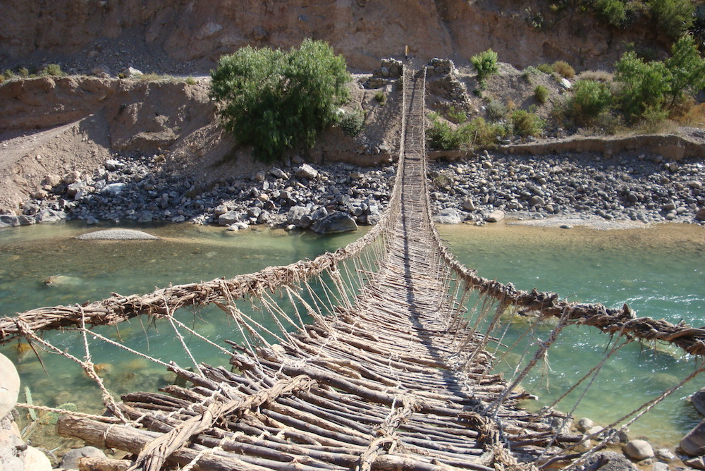
ONE EARLY JANUARY morning in the mid-1980s after a daylong journey from Ayacucho (formerly “Guamanga”), I (Lidio) found myself being guided across a small rope bridge hanging across the Pampas River. This was my first experience on such a bridge, made with an astonishing ancient technology that uses twisted branches to form a crossing. Although it looked to be only about 20 meters long, the bridge, called Chuschichaka, was beautiful: a reminder of ancient times, when similar bridges existed along trails and roads that linked the Inca Empire.
From the town of Chuschi, where I started my journey that day, my destination of Sarhua seemed to be just nearby. But because of the rugged landscape, the trip was long and exhausting: It took hours to hike the distance, with the rope bridge in the middle. At last, our team arrived in Sarhua and was welcomed by the community with food, drinks, music, and dance. Their hospitality made our visit an incredible and unforgettable experience.
My mission at that time as an archaeologist was to investigate ancient agricultural terraces in the region. As I prepared for my work, I was told that there was an important activity taking place that day: the reconstruction of a larger bridge nearby called Tinkuqchaka.
Except for a few older and younger people who were staying in the town, most community members were already on their way to the site of Tinkuy (a name that means “a place to meet,” “a place to play,” or “a place to fight”) to take part in bridge reconstruction. Sadly, I could not spare the time to attend, though I would hear all about such work later from my friend and colleague—anthropologist Cirilo Vivanco (co-author), who is originally from Sarhua.
When I left the community three days later in the early hours of the morning, Tinkuqchaka was not yet finished. We crossed the partially constructed bridge by flashlight, holding the handrails tightly.
THE ANCIENT PRACTICE of making hanging bridges has existed for a long time in Peru—perhaps going back as far as the Wari culture, which thrived from A.D. 600–1000. At one time, dozens of such bridges are thought to have connected communities across gorges and rivers. Today only a few remain, mainly for the sake of tourists, and even they are falling into disrepair. Just this April, the most famous of them—Queshuachaca, near the former Inca capital of Cuzco—collapsed from lack of maintenance.
The global appreciation of the hanging bridges of the Andes goes a long way back. In 1877, American archaeologist E. George Squier published Peru: Incidents of Travel and Exploration in the Land of the Incas, in which he devoted a few pages to the great hanging bridge over the Apurímac River on the main road to Cuzco. The bridge was built over a gigantic valley, enclosed by enormous and steep mountains. The over 40-meters-long structure, entirely made of plant materials, was hung from massive cliffs on both sides. To Squier, the bridge looked like a mere thread, a frail and swaying structure, yet frequently crossed by people and animals, the latter carrying loads on their backs. Travelers timed their day’s journey to reach the bridge in the early hours of the day before the strong winds came that made the bridge sway “like a gigantic hammock.”

This drawing from American archaeologist E. George Squier’s 1877 book on Peru shows a rope bridge over the Apurímac River.
E. George Squier/Wikimedia Commons
Squier was very impressed, saying that his crossing was an experience he “shall never forget.” His description and accompanying image of the bridge no doubt captured the imagination of everyone who got ahold of Peru: Incidents of Travel and Exploration in the Land of the Incas—including American explorer Hiram Bingham, famous for reporting the existence of the spectacular Inca city of Machu Picchu to a global audience in 1911. According to historians, one of the reasons Bingham decided to go to Peru in the first place was precisely the illustration of the Apurímac hanging bridge he saw in Squier’s book.
Long before Squier, Spaniards were impressed with the Inca hanging bridges too. Early Spaniards, such as Pedro de Cieza de León, were fascinated. But the arrival of the Spaniards had devastating effects for local Indigenous peoples. Europeans brought diseases that decimated the Indigenous populations. Communities were reduced or totally deserted. Spaniards’ interest in precious minerals, such as gold and silver, also switched the efforts of Indigenous peoples to other activities, often leaving unattended other communal obligations, such as building the bridges.
Tinkuqchaka was one of the few bridges to survive into the 2000s.
THREE YEARS AFTER my first trip to Sarhua, I was back again, this time on a mission to register the archaeological sites scattered around Sarhua along with Cirilo, as we recently published in the Journal of Anthropological Research. On our way, we crossed Tinkuqchaka again and bathed in the Pampas River below the bridge.
As we watched the bridge swaying delicately over the river, Cirilo told me about how Tinkuqchaka, being built entirely of plant material, required annual maintenance and a total renewal every two years. He told me, too, how the community, including himself, came together to do this. From my conversations with Cirilo, the story of this touching activity became clear to me.

Catherine Gilman/SAPIENS
Following ancient Andean ideals, the community of Sarhua is divided into two groups or ayllus. One of the ayllus is regarded as local while the other is said to be made up of “outsiders,” perhaps the descendants of peoples who were relocated by the Inca from elsewhere within the Inca realm. Both ayllus coexist side by side, and it is believed that such a division is necessary to maintain a balance needed for the well-being of the community. Sarhua residents do not usually highlight their group membership, except during communal activities like the bridge rebuilding.
One person, named by the community, is responsible for looking after the bridge. As in Incan times, the title of this person is chakakamayuq. Bridge renewal begins with a notification by the chakakamayuq to the community, which begins collecting the necessary construction material—the branches of a bush named pichus. Then, on a specified day, community members descend from Sarhua, carrying on their shoulders pichus branches to Tinkuy.
Kumumpampa, an open space found near the bridge, is the gathering place. At this location, both ayllus take their respective positions, the local ayllu closer to Sarhua and the ayllu of outsiders closer to the Pampas River, symbolically distant from Sarhua. After necessary logistical discussions, the ayllus exchange jokes and challenge each other, thus making the whole activity an entertainment or spectacle. For the participants, it is a competition between the two ayllus but also a game, time to play and time to tease and mock the opposition.
The task ahead for both ayllus is, first, to produce 23 ropes 100 meters long, called aqaras, from the pichus branches. Bundles of nine pichus branches are tied together and braided. The ayllu that produces more ropes will be declared the winner. Defeat is shameful, and thus both ayllus strategize to ensure victory. This is largely a male activity, but women of both ayllus are engaged by preparing meals and cheering for their respective side, mocking the men of the opposite ayllu.

Community members work hard to secure the heavy cables.
Cirilo Vivanco
Producing the aqaras is only the first challenge. The second task is to produce five thicker cables from the aqaras. This is a more difficult job. Starting at a middle point, teams from the ayllus build half of the cable working outward, again in competition. Experienced members are in charge, while younger members observe, fully aware that in the future it will be their turn. At the end, one of the ayllus emerges the winner and is celebrated with loud shouts. Victory is sweet and joyful, while defeat is ugly, painful, and agonizing.
Upon completing the five cables, work shifts to the edge of the river, on either side of which stands a stone tower. Members of the outsider ayllu cross to the opposite side of the river using the old bridge for one last time; then the old bridge is cut at both ends and is carried downstream by the Pampas River, thus marking the end of a cycle and reinforcing, temporarily, the separation of the outsiders.
The whole task of completing the bridge takes about five days.
The renewal of Tinkuqchaka illustrates the complementary role of the ayllus and their necessary reunion for the vitality of the community. Local ayllu members throw ropes to the opposite bank of the river, retaining one end in their hands. Since bridge construction takes place during the rainy season, when the river carries lots of water, this is not an easy task. The local ayllu ties the rope to the first thick cable so it can be pulled across the river. The cables are as thick as a person’s body, made of wet branches and heavy. It takes hours to pull the five cables across the river and tie each securely behind the stone tower on the far side.
Three cables, pulled taut and horizontal, become the base of the bridge over which small sticks are laid transversely and fastened to the cables by cords. Two smaller cables become the handrails.
The whole task of completing the bridge takes about five days, during which time the entire community remains at Tinkuy. While the days are spent working, evenings are time to socialize, drink, sing, and dance, and thus renew the sense of community. The community, aware of the historical significance of the bridge, is also proud of being responsible for carrying forward this tradition.
THE TECHNOLOGY EMPLOYED to build Tinkuqchaka appears to be ancient. The manner by which the bridge is built perhaps also resembles ancient customs. No one knows for sure. The fact that communities such as Sarhua are capable of undertaking such impressive construction and engineering feats shows the power of unified action.
There is the possibility that hanging bridges predate the Inca Empire. Large sections of the Inca royal highway already existed before the Incas, and along the same roads, there were several river crossings, thus suggesting that the bridge technology already existed. Demonstrating this possibility, of course, is not easy. There are no written records from this time, and the plant material of the bridges left no archaeological traces.
The hanging bridge constitutes an important symbol of the technology developed by the forebears of the Indigenous peoples of this region (including myself and Cirilo). In a perfect world, it would be rightfully considered a monument to the creativity and imagination of the Indigenous peoples of the Andes and maintained to showcase to the world this unique achievement of unknown origins.

The local and outsider ayllus gather on opposite sides of the river.
Cirilo Vivanco
Of course, there is no such perfect world, and decision-makers have other priorities. As Andean philosophy teaches, everything has an end. The hanging bridges are not an exception.
For the residents of Sarhua, a cable bridge was built in 1992 that effectively ended the biennial construction of the rope bridges. In 2007, a larger bridge that could carry cars was built. Tinkuqchaka was made anew in 2010 and reconstructed for the last time in 2014 for the sake of tourism. The local youth seem uninterested in renewing the tradition.
It appears we have come to witness the end of something wonderful, unique, and to foreign eyes, spectacular. Something that was present almost everywhere in this region is fading away forever, and some of us who had the fortune to see and walk on these bridges sometimes took them for granted, without realizing that within our lifetime an important chapter of Andean history was coming to an end.

Archaeologists plan to fully restore ancient Mayan temples
Archaeologists from the Mexican National Institute of Anthropology and History began restoration work on an ancient Mayan temple in the Dzibilchaltun archaeological site in eastern Mexico.
Watch the video below:
Archeologists uncover ancient civilization burial sites in Peru
Archeologists found seven burial sites belonging to an ancient civilization dating from VII and XII A.D in Huarmey, Peru.
The discovery made by Polish archeologists in western Peru is related to the Wari culture and reveals the existence of an elite group of artisans dedicated to manufacturing pieces of great ornamental value.
The burials belong to two women, two men, two children and a young man, among which was the bundle of a personage dressed with jewelry, ceramics, textiles, tools and handicrafts.
The new finding is related to a previous one made in 2012, near the current tomb, where a mausoleum of 64 Wari women was found.
1,000 years ago, a woman was buried in a canoe on her way to the 'destination of souls'
The woman was on her 'final voyage."

An illustration of deceased young woman lying in a wampos (ceremonial canoe) with a pottery jug near her head. (Image credit: Pérez et al., 2022, PLOS ONE, CC-BY 4.0)
Up to 1,000 years ago, mourners buried a young woman in a ceremonial canoe to represent her final journey into the land of the dead in what is now Patagonia, a new study finds.
The discovery reaffirms ethnographic and historical accounts that canoe burials were practiced throughout pre-Hispanic South America and refutes the idea that they may have been used only after the Spanish colonization, according to the authors of the study.
"We hope this investigation and its results will resolve this controversy," said archaeologist Alberto Pérez, an associate professor of anthropology at the Temuco Catholic University in Chile and the lead author of the study, published Wednesday (Aug. 24) in the journal PLOS One(opens in new tab).
Canoe burials are well attested and are still practiced in some areas of South America, Pérez told Live Science. But because wood rots rapidly, the new finding is the first known evidence of the practice from the pre-Hispanic period. "The previous evidence was important and was based on ethnographic data, but the evidence was indirect," he said.

The archaeological site in the northwest of Argentina was excavated between 2012 and 2015 before a well was built at the location, which is on private land. (Image credit: Pérez et al., 2022, PLOS ONE, CC-BY 4.0)
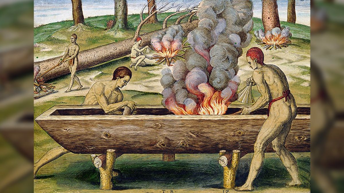
The burial described in the study, at the Newen Antug archaeological site near Lake Lacár in western Argentina, indicates that mourners buried the woman on her back in a wooden structure crafted from a single tree trunk that had been hollowed out by fire.
The same burning technique has been used for thousands of years to make "dugout" canoes known as "wampos" in the local Mapuche culture, and evidence suggests that Indigenous people prepared the woman's remains so that she could embark on a final canoe journey across mystical waters to her final abode in the "destination of souls," Pérez said.
Pre-Hispanic burial
The woman's grave is the earliest of three known pre-Hispanic burials at the Newen Antug site, which archaeologists excavated between 2012 and 2015, before a well was built at the location, which is on private land. The location is at the northern extreme of the region known as Patagonia, which consists of the temperate steppes, alpine regions, coasts and deserts of the southern part of South America.
Radiocarbon dating indicates the woman was buried more than 850 years ago and possibly up to 1,000 years ago, while her sex and age at death — between 17 and 25 years old — were estimated from her pelvic bones and the wear on her teeth, according to the study. (Evidence suggests the Mapuche have lived in the region since at least 600 B.C.)
A pottery jug decorated with white glaze and red geometric patterns, placed in the grave by her head, suggests a connection with the "red on white bichrome" tradition of pre-Hispanic ceramics on both sides of the Andes mountains, the researchers found. This is the earliest known example of this type of pottery being used as a grave gift, according to the study.
Canoes known as wampos in the Mapuche language were constructed by hollowing out a single tree trunk with fire, with thicker walls at the bow and stern. (Image credit: Pérez et al., 2022, PLOS ONE, CC-BY 4.0)
Given its age and the humid climate, the burial canoe has rotted away, and only fragments of wood remain. But tests suggest that the fragments came from the same tree — a Chilean cedar (Austrocedrus chilensis) — and that it had been hollowed out with fire.
Shells found in the grave show that her body was placed directly on a bed of Diplodon chilensis, a type of freshwater clam that was likely brought from the shores of Lake Lacár more than 1,000 feet (300 meters) away, the researchers wrote.
In addition, the position of the body — with the arms gathered above the torso, and the head and feet raised — indicate that the woman was buried inside a concave structure with thicker walls at the ends, which correspond to the bow and stern of a canoe, Pérez said.
Taken together, these aspects suggest the woman was interred in a traditional canoe burial representing the Mapuche belief that a soul must make a final boat journey before it arrives in the land of the dead. "The material evidence all goes in the same direction, and there is a whole battery of ethnographic and historical information that accounts for it," Pérez told Live Science in an email.
Destination of souls
According to Mapuche belief, the destination of the deads' souls was "Nomelafken" — a word in the Mapuche language that translates to the "other side of the sea" — and the newly dead would make a metaphorical boat journey for up to four years before they arrived at a mythical island called Külchemapu or Külchemaiwe, Pérez and his colleagues wrote in the study.
A historical report from the 1840s by the Chilean politician Salvador Sanfuentes remarked that local people "site the graves of their dead on the bank of a stream to allow the current to carry the soul to the land of souls" and that ceremonial canoes were buried as coffins to carry the dead on this journey, the researchers wrote.
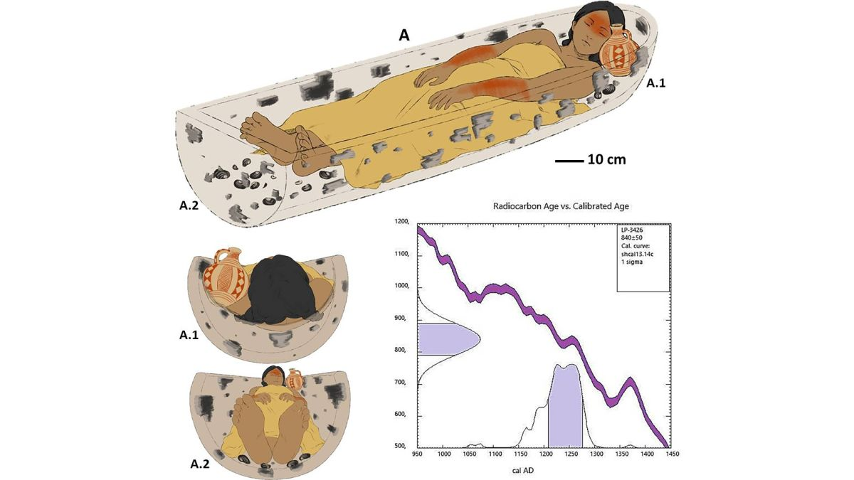
The young woman was buried more than 800 years ago in a wampo, or ceremonial canoe, that researchers think symbolized a boat journey to the land of the dead. (Image credit: Pérez et al., 2022, PLOS ONE, CC-BY 4.0)
The metaphor of the recently deceased making such a canoe journey to a final destination seems to have been prevalent throughout South America in pre-Hispanic times, and possibly for thousands of years, Pérez noted.
"We infer that this was a widespread practice on the continent, although it is little known to archaeology due to conservation problems," such as the degradation of wood in humid climates, he said. "The antiquity of these practices is uncertain, but we know such navigation technologies were used there more than 3,500 years ago, so we can estimate that date as a potential time limit."
The new study has great scientific importance for archaeological and anthropological research in the Patagonia region, said Nicolás Lira, an assistant professor of archaeology, ethnography and prehistory at the University of Chile who wasn't involved in the research.
"The findings … are of exceptional preservation for the humid environment of the region, where rivers and lakes shape the landscape in an interconnected [river] system that facilitated and encouraged navigation," Lira told Live Science in an email.
Juan Skewes, an anthropologist at Alberto Hurtado University in Chile who wasn't involved in the study, said the Newen Antug burial was "strong evidence" of a shared cultural tradition between the east and west "slopes" of the Andes.
Meanwhile, historical and ethnographic records suggest such canoe burials represented a symbolic relationship between the Mapuche people and bodies of water, but that relationship wasn't their only consideration, Skewes said. For example, "trees are part of almost every aspect of the Mapuche's daily life, Skewes said. "Aside from having associations with mortuary practices, they are linked to childbirth and to the memories of the dead." That might mean that the construction of a burial wampo from a single tree could have had an extra meaning, in addition to the canoe's symbolic function during the final voyage of the dead, he said.
Originally published on Live Science.

A section of forest is empty after it was cleared for the construction of the Maya Train near community La Vida y Esperanza, which means Life and Hope, center left, and traverses a small road that connects the community with the highway, in Quintana Roo state, Mexico, Friday, Aug. 5, 2022. Unless the army, which is building the train line, constructs a large overpass bridge above the tracks, villagers would be forced to take a back road four times as long to get to the highway, and it would no longer make economic sense to live there. (AP Photo/Eduardo Verdugo)
Mexican rail project imperils Maya village’s water: "We are running the risk that all this will be buried"
By Mark Stevenson | Associated Press
VIDA Y ESPERANZA, Mexico — Mexico’s ambitious Maya Train project is supposed to bring development to the Yucatan Peninsula, but along the country’s Caribbean coast it is threatening the Indigenous Maya people it was named for and dividing communities it was meant to help.
One controversial stretch cuts a more than 68-mile swath through the jungle between the resorts of Cancun and Tulum, over some of the most complex and fragile underground cave systems in the world.
It is one of President Andrés Manuel López Obrador’s signature projects and has drawn objections from environmentalists, archaeologists and cave divers, who have held protests to block backhoes from tearing down trees and scraping clean the thin layer of soil.
But for the largely Maya inhabitants of the village of Vida y Esperanza – a clutch of about 300 people and 70 houses whose name means “Life and Hope” – the train is going to run right by their doors. They fear it will pollute the caves that supply them with water, endanger their children and cut off their access to the outside world.
A few miles away from the acres of felled trees where the train is supposed to run, archaeologist and cave diver Octavio Del Rio points to the Guardianes cave that lies directly beneath the train’s path. The cave’s limestone roof is only two or three feet thick in some places, and would almost certainly collapse under the weight of a speeding train.
“We are running the risk that all this will be buried, and this history lost,” Del Rio says.
López Obrador dismisses critics like Del Rio as “pseudo environmentalists” funded by foreign governments.
As with his other signature projects, including a new airport in the capital and a massive new oil refinery on the gulf, the president exempted the train from environmental impact studies and last month invoked national security powers to forge ahead, overriding court injunctions.
Many critics say López Obrador’s obsession with the projects threatens Mexico’s democratic institutions. But the president counters that he just wants to develop the historically poor southern part of Mexico.
“We want to take advantage of all the tourism that arrives in Cancun, so they can take the Maya Train to see other natural beauty spots, especially the ancient Mayan cities in Yucatán, Campeche, Chiapas, Tabasco,” which are poor neighboring states, López Obrador said earlier this month.
But the Maya themselves are people scraping a living from the limestone bed of the dry tropical jungle. The ancient Mayan civilization reached its height from 300 A.D. to 900 A.D. on the Yucatan Peninsula and in adjacent to parts of Central America, and they are best known for constructing monumental temple sites like Chichen Itza.
The Mayas’ descendants continue to live on the peninsula, many speaking the Mayan language and wearing traditional clothing, while also conserving traditional foods, crops, religion and medicine practices, despite the conquest of the region by the Spanish between 1527 and 1546.
“I think that there is nothing Maya” about the train, said Lidia Caamal Puc, whose family came from the Mayan town of Peto, in the neighboring Yucatan state, to settle here 22 years ago. “Some people say it will bring great benefits, but for us Mayas that work the land, that live here, we don’t see any benefits.”
“Rather, it will hurt us, because, how should I put it, they are taking away what we love so much, the land.”
When marines showed up last month to start cutting down trees in preparation for the train on the edge of the village, residents who hadn’t been paid for their expropriated land stopped them from working.
The head of the village council and a supporter of the train, Jorge Sánchez, acknowledged that the government “had not paid the people who were affected” even though the government has said they will get compensation.
But it’s not just about the money, Sánchez said. “It will bring back jobs for our people.”
The 950-mile (1,500-kilometer) Maya Train line will run in a rough loop around the Yucatan Peninsula, connecting beach resorts and archaeological sites. But in Vida y Esperanza, the train will cut directly through the narrow, rutted four-mile (six-kilometer) dirt road that leads to the nearest paved highway.
For more than two years, Mayan communities have been objecting to the train line, filing court challenges arguing the railway violated their right to a safe, clean environment, and to be consulted; in 2019, the Mexico office of the U.N. High Commissioner for Human Rights found that what consultations the government did do were flawed.
The question about the economics of the train, and tourism income, is more complex, in part because no credible feasibility studies were done. The project is expected to cost about $8 billion — but appears likely to rise to as much as $11 billion — while the government calculates it will bring in $9.5 billion in revenue or “benefits.”
But those estimates are widely doubted because López Obrador is essentially betting on luring sun-and-sand beachgoers to the ruins and Indigenous towns for so-called “cultural tourism.” It is not clear how many want to combine those two activities, especially if the highspeed train zooms past the beauties of the low jungle.
International tourism to the country has started to recover from pandemic losses, with the strongest showing from U.S. visitors. In the first half of 2022, just over 10 million tourists arrived from January to June, 1.5% higher than the first half of 2019. But overall tourist spending remains below pre-pandemic levels.
Unless the army, which is building the train line, constructs a large overpass bridge above the tracks, villagers would be forced to take a back road four times as long to get to the highway. It would no longer make economic sense to live there.
The government tourism agency that oversees the train project, Fonatur, says an overpass will be built for Vida y Esperanza. But such promises have gone unfulfilled in the past.
And the army plans to fill the underground caves to support the weight of the passing trains, which could block or contaminate the underground water system.
The high-speed train can’t have at-grade crossings, and won’t be fenced, so that 100-mile per hour (160-kph) trains will rush past an elementary school. Most of the students walk to get there.Just as bad, the train project has divided Vida y Esperanza.
Luis López, 36, who works at a local store and opposes the train, said “it might bring minor benefits, but it has downsides.”
“The cenotes will be filled or contaminated,” he said, referring to the sinkholes that villagers rely on. “I survive on the water from a cenote, to wash dishes, to bathe.”
Many residents of Vida y Esperanza, who rely on diesel generators, would much rather have electricity than a tourist train that will rush by and never stop there.
Mario Basto, 78, a wiry resident who works as a gardener, said he’d rather have decent medical care than the train.
“It seems like the government has money it just needs to get rid of, when there are hundreds of hospitals that don’t have medicine,” Basto said.
And there are some people in Vida y Esperanza who support the train project, almost entirely because of jobs it has brought during construction.
Benjamin Chim, a taxi and truck driver who is already employed by the Maya Train, will also lose part of his land to the project. But he says he doesn’t care, noting “it is going to be a benefit, in terms of jobs.”
“They are taking a bit of land, but it’s a bit that doesn’t have any symbolic value, for me it doesn’t mean anything,” Chim said.
While the president’s supporters have claimed that anybody who opposes the train isn’t really Mayan, that would be news to people in Vida y Esperanza, where residents swear that Mayan spirits, known as “Aluxes,” inhabit the forest.
Locals pacify the spirits by leaving a small drink of wine out for them.
Bright blue-green Toh birds, tarantulas, blue morpho butterflies, iguanas and the occasional jaguar cross the roads and jungle.
And it would also threaten something older than even the Mayas.
Del Rio, the archaeologist, discovered human remains of the Maya’s ancestors that may date as far back as 13,700 years in another cave network – but it took him and other divers 1 1/2 years to snake through a single cavern system. “This is work that takes years, years,” he said.
López Obrador wants to finish the entire train in 16 months by filling the caves with cement or sinking concrete columns through the caverns – the only places that allowed humans to survive in this area.
But for the villagers, much of the damage has already been done.
“They have already stolen our tranquility, the moment they cut through to lay the train line,” Caamal Puc said.

The LSU Campus Mounds pictured here are the oldest known man-made structures in North America. Credit: LSU
New research shows campus mounds are the oldest known human-made structures in North America
New research reveals more information about the LSU Campus Mounds, including the discovery of thousands of years old charred mammal bone fragments and a coordinated alignment of both mounds toward one of the brightest stars in the night sky. This new information offers more insight into the oldest known man-made structures in North America.
The two large, grassy mounds that are about 20 feet tall, on LSU's campus, are among the more than 800 man-made, hill-like mounds in Louisiana, built by ancient indigenous people. While many mounds in the region have been destroyed, the LSU Campus Mounds have been preserved and are listed on the National Register for Historic Places.
"There's nothing known that is man-made and this old still in existence today in North America, except the mounds," said LSU Department of Geology & Geophysics Professor Emeritus Brooks Ellwood, who led this study, published in the American Journal of Science by Yale University.
He and colleagues collected sediment cores from the two mounds that are located on LSU's campus along Dalrymple Drive to learn more about them. The cores revealed layers of ash from burned reed and cane plants, as well as the burned bone fragments. Radiocarbon dating of the layers of material indicates the mounds were built over thousands of years. These findings show that people began to build the first mound about 11,000 years ago. The scientists think that sediment for the southern mound, which they've named "Mound B," was taken from a location immediately behind LSU's Hill Memorial Library, because there is a large depression in the ground there. The mound was built up over a few thousand years, layer by layer, to about half of its current height.
The layers of ash and charred microscopic bone fragments may indicate the mound was used for ceremonial purposes, which included burning reed and cane plants to make large, hot fires that would have been too hot for cooking. The scientists do not know what type of mammals were cremated or why. However, they found many microscopic, charred bone fragments, known as osteons, the building blocks of large mammal bones, in the ash beds in both LSU Campus Mounds.
Then, around 8,200 years ago, the southern Mound B was abandoned. Tree roots found in the 8,200-year-old sediment layer indicate that the mound was not used for about 1,000 years. Also around 8,200 years ago, the northern hemisphere experienced a major climate event with temperatures suddenly dropping on average by about 35 degrees Fahrenheit, which lasted about 160 years.
"We don't know why they abandoned the mounds around 8,200 years ago, but we do know their environment changed suddenly and dramatically, which may have affected many aspects of their daily life," Ellwood said.
Then, around 7,500 years ago, the indigenous people began to build a new mound just to the north of the first mound. However, this time, they took mud from the floodplain where the entrance to LSU's Tiger Stadium is currently located, which at that time was an estuary. With this mud, they built the second mound, "Mound A," layer by layer, to about half of its current height. Mound A contains mud that is saturated with water, which liquefies when agitated. As a result, Mound A is unstable and degrading, which is why it is critical to stay off the mounds to preserve them.
According to the new analyses of the sediment layers and their ages, it looks like indigenous people cleared the abandoned first-built Mound B and began to build it up to its current height before completing Mound A. Both mounds were completed around 6,000 years ago and are similar in height.
The crests of both mounds are aligned along an azimuth that is about 8.5 degrees east of true north. According to LSU astronomer and study coauthor Geoffrey Clayton, about 6,000 years ago, the red giant star Arcturus would rise about 8.5 degrees east of north in the night sky, which means it would have aligned along the crests of both LSU Campus Mounds. Arcturus is one of the brightest stars that can be seen from Earth.
"The people who constructed the mounds, at about 6,000 years ago, coordinated the structures' orientation to align with Arcturus, seen in the night sky at that time," Ellwood said.
Still, there is more to learn and discover about these archaeological treasures on LSU's campus.
Archaeologists unearth pocketknife at historic Michigan fort
MACKINAW CITY, MICH. -- More fascinating discoveries have been made at Michigan’s Colonial Michilimackinac as the historic site’s archaeology season winds to a close.
Archaeologists at the reconstructed 18th-century fort and fur-trading village recently found several pieces of ceramics that match a bowl uncovered in June, as well as a possible sugar bowl and a pocketknife.
These finds follow the discovery of a pair of green glass sleeve buttons, unearthed earlier this month.
The artifacts are just the latest in a summer full of discoveries made at the fort’s current archaelogical dig site. So far this season, archaeologists have found part of a red earthenware bowl, a one-ounce brass weight marked with a crown, a fleur-de-lis stamped brass weight from a set of nesting apothecary weights, a King’s 8th button, and more.

A pocketknife was recently found during the ongoing archaeological dig at Colonial Michilimackinac in Mackinaw City, Mich. | Photo courtesy of Mackinac State Historic Parks
This year’s discoveries add to the more than 1,000,000 artifacts unearthed over six decades at Colonial Michilimackinaw, one of a number of living history museums and nature parks in northern Michigan’s Straits of Mackinac that are overseen by Mackinac State Historic Parks.
The current excavation site at Michilimackinac is the fort’s “House E,” where work in recent years has uncovered artifacts such as a lead seal dating between 1717 and 1769, a brass sleeve button with an intaglio bust on it, a potential structural post dating to the original 1715 fort, an engraved “Jesuit” trade ring, a brass serpentine sideplate for a British trade gun, complete remnants from a creamware plate, and many other items.
The archaeological dig at Michilimackinac began in 1959, making it one of the longest-running archaeology programs in North America. Archaeologists are on site every day at the fort, weather permitting, throughout the summer. The final day of the 2022 archaeology season is August 20.

The cliff homes were lost until the end of the 19th century when people began looting artefacts from them (Image: Getty Images/RooM RF)
Incredible remains of stunning ancient Native American village carved out of cliff
The Cliff Palace in Colorado's Mesa Verde National Park is a part of a wider network of stone dwellings that the Pueblo people ingeniously built during the 12th century
Mesa Verde, which translates as 'green table' in Spanish, is the biggest archaeological preserve in the US.
The ancient sites inside the 52,000-acre national park in Colorado were home to Puebloans, Native Americans of the south-west US, who during the 13th century chiselled entire villages out of the side of cliffs.
They did not leave behind any writings but the archaeological remains and oral stories passed down the centuries has meant researches have been able to piece together what life was like for them back then.
At some point in the late 1190s the Anasazi people, a Navajo word for those who lived in the Mesa Verde region, moved from living on the top of cliffs to the bottom of them inside the deep natural alcoves.

Puebloans are Native American Indian people specific to south-western US (Image: Getty Images/RooM RF)
In 2011, researchers noted that the area had cold, snowy winters that led to some extended periods of drought during the summer period.
However, the harsh environment was met with "resilience" by the people.
The dwellings they built ranged from one-room granaries, which made up about three quarters of the site's buildings, all the way up to entire villages spanning 150 different rooms.

The cliff dwellings were deserted by its inhabitants around 1300 possibly due to droughts and violence
The construction of these structures were continually evolving and changing for almost one century.
By 1300 the cliff dwellings of Mesa Verde were abandoned by the Anasazi, possibly due to the effects of drought and even violence, and the stunning site fell slowly into disrepair over the centuries.
However, it was rediscovered in 1880 and, after some initial looting of the site, the Mesa Verde area was tuned into a national park in 1906 and preserved for future generations to wonder at the ingenuity of ancient Puebloans.
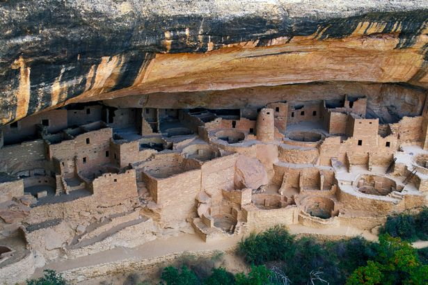
Some of Cliff Palace's room can only accessed by a ladder - the same way the ancient residents used to enter them (Image: Mark Newman/ The Image Bank RF)
Mesa Verde National Park houses many man-made structures but its most famous relic is the Cliff Palace - the largest cliff dwelling in North America - that around 100 inhabitants live in and took 70 years to complete.
It is believed to be a village that was well protected from the elements and used for social and administrative purposes and also with high ceremonial usage thanks to its 23 kivas (special subterranean rooms designed for ritual use).
A mixture of mud and stone mortar was used to build the village and many walls were decorated in multi-coloured murals of red, yellow, pink, brown and white plaster - some of which have survived.
Visitors today can access some the rooms in the same way as when they were first built - through the roofs via a retractable ladder - for an authentic experience of what life was like among the cliff dwellers back then.
LiDAR technology confirms the existence of a "Lost City" in the Brazilian Amazon
APIACÁS, Brazil, Aug. 17, 2022 /PRNewswire/ -- The Brazilian Amazon may be the cradle of the oldest city in the world.The mapping analysis performed by LiDAR (Light Detection And Ranging) technology in Apiacás/MT indicates it. The laser scanning is performed by an airplane, the technology uses pulses of laser that can penetrate through the vegetation without needing to deforest the bush. The images, published on Sunday (August the 7th 2022), during a live YouTube broadcast on Dakila Research´s channel (Dakila being an association of independent researchers) show that the place, "Apiacás Lines", was man made.

Ratanabá laser scanning. Photo credit: Ecossistema Dakila.
In June, authorized by the Brazilian Ministry of Defense, using its own resources, Dakila´s researchers used two aircrafts to fly over and track the place known as "The Apiacás Lines" in order to laser scan the area with LiDAR technology. Aerial images of the place showed surprising symmetrical patterns that can be seen with the naked eye. The lines appear to be squares or streets of a possible ancient city. According to dating carried out by researchers from the Universidade Estadual Paulista (UNESP- São Paulo State University), in Rio Claro (SP), a group of rocks found on the site are about 1.5 billion years old.
"It's been more than 30 years of research to find that place. It might be one of the greatest discoveries of all time: Ratanabá, the "Lost City" in the Brazilian Amazon. According to our studies, Ratanabá was the capital of the world, built by the Muril, a pre-diluvian civilization and its ramifications go beyond the Brazilian Amazon, extending all over the world, according to Urandir Fernandes de Oliveira, president of Dakila Research Association. Dakila Research currently has 16 bases of investigation in the Amazon states such as Rondônia, Amazonas, Amapá, Roraima and Acre.
During Dakila´s live broadcast on it´s Youtube channel, archaeologist Saulo Ivan Nery explained that the presence of these "straight lines" on the ground are totally different than the natural patterns of surface erosion found in the region, alleging anthropic origin (man-made) of the "lines".
Surveys of the local topography and of river basins in the area were carried out by the Brazilian Army and the Brazilian Geography Institute, used in a comparative study with the LiDAR images, have confirmed human intervention.
The total area scanned using the LIDAR technology on the "Apiacás Lines" encompass 95 hectares, of which we can identify around 30 "blocks" and 30 "streets". The "blocks" have a height of about 50 meters in relation to the ground.
In different places of the Amazon Forest, sophisticated metal objects have been found, such as coins, medals, chests and swords; unkonwn rocks that have a strange glow in the dark; elongated skulls that have about 80 cm of cranial length and a fossilized footprint on a rock that is more than two meters in size.
SOURCE: Associação Dakila Pesquisas
'Lost' Ancient City in Mexico had as many buildings as Manhattan
Thousand-year-old 'lost' pyramid city uncovered in the heart of Mexico using lasers had as many buildings as modern Manhattan

Experts used lasers to send beams of light from an aircraft to the ground below to build up a map of the area
They discovered a lost pyramid city known as Angamuco built by the Purépecha, rivals to the Aztecs
The city was more than double the size of Tzintzuntzan, the culture's capital, at 10 square miles (26 sq km)
It contained 40,000 building foundations which is roughly the same as on the island of Manhattan
In Mexico, a remarkable discovery was made that took the globe by storm. An ancient civilisation lived in this location, according to the archaeologist team conducting the digs, and the metropolis may have had as many buildings as modern-day Manhattan.
The finding was uncovered west of Mexico City, near the metropolis of Morelia, where an old city dating back to 900 AD appears to be located.
It was initially inhabited by the Purepecha culture. They are well-known for being the Aztecs’ adversaries.
The city was initially built on thousands of years old lava flow and covered an area of more than 16 square miles.

The findings, which were announced during the 2018 AAAS Annual Meeting in Austin, Texas, have implications for understanding the region’s history of migration, land use and conservation and even early climate changes, participants said.
Using airborne mapping, researchers are discovering new archaeological sites that show pre-Columbian Mesoamerica was 'significantly more densely populated at the time of European contact' than previously thought.
Professor Fisher pointed to a previous city he has studied in the Mosquitia Rainforest of Honduras.
Thousands of Mayan people lived in complex cities with central plazas, pyramids, reservoirs, canals and terraced farmlands in this area 1,000 to 2,000 years ago.
Using Light Detection and Ranging scanning, the team was able to determine how many structures existed in the city in the first place, as well as how huge they could have been. The data were quickly delivered to them, and they were astounded, to say the least, to learn that over 40,000 buildings may have been constructed here in ancient times.
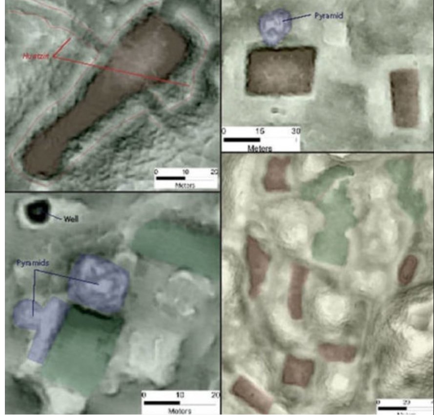
The city of Angamuco was discovered in 2007, but no one expected it to be as large or modern as it was.
Sometime in the 1530s, Europeans discovered these cities and brought new diseases that killed an estimated nine out of 10 people of the city’s residents within a generation, Professor Fisher said.
There is evidence that the cities’ remaining residents ritually de-sanctified their religious sites before abandoning them, which were subsequently forgotten and hidden by dense tropical forests.
Documenting these sites now is critical, because 'accelerating rates of global change are threatening our patrimony in ways we’ve never seen before,' Professor Fisher added.
Researchers announced the groundbreaking discovery of more than 60,000 previously unknown structures including pyramids, palaces, and causeways, that once made up a massive pre-Columbian civilization.

To uncover the megalopolis, the team used Lidar to look beneath the forest canopy in northern Peten - an area close to already-known Mayan cities.
The discovery suggests that Central America supported a civilization that was, at its peak 1,500 years ago, more advanced than ancient Greek and Chinese cultures.
The landscape may have been home to up to 15 million individuals and the abundance of defensive walls, ramparts and fortresses suggests that warfare was rife throughout their existence and not just at the end.
Hundreds of ancient treasures seized by US Customs returned to Mexico
Mexico has recovered more than 400 archaeological treasures dating back hundreds of years after they were seized in the U.S.
The 428 artifacts include arrowheads, spear tips and knives, in addition to tools and hide scrapers dating back to between 900 A.D. and 1600 A.D. They have also recovered fossils of a 60-million-year-old marine oyster.
The treasures were handed over to Mexico's consulate in Portland, Oregon, by the U.S. Customs and Border Protection Office.

One of many objects seized by Mexican authorities in an undated picture. They got by the US authorities. (/ Zenger)
INAH/Zenger
Mexico’s Nationwide Institute of Anthropology and Historical past (INAH) launched a press release from Zenger Information on Tuesday, which stated: “The INAH has preserved many items from desert cultures, comparable to projectile factors, flint knives, shell and bone artifacts, marine fossils and natural parts.
“They had been seized by america Customs and Border Safety and delivered to the Mexican consulate in Portland.”
The institute stated it obtained the articles from the Mexican Ministry of International Affairs after the ministry obtained the articles from america.
The Mexican company additionally stated: “Throughout the formalization of the cargo, which happened on the State Division’s headquarters, the efforts of the U.S. authorities, whose Customs and Border Safety Company seized the amount of things associated to historical cultures settled in northern Mexico, had been highlighted delivered them to the Mexican consulate in Portland, Oregon.”

One of many objects seized by Mexican authorities in an undated picture. Treasures recovered from america included arrowheads, scrapers created from shell and bone, and knives.
INAH/Zenger
Jaime Alejandro Bautista Valdespino, Deputy Director of the Register of Movable Archaeological Monuments at INAH, who oversaw the handover, stated that based on preliminary info, the objects transferred to Mexico by diplomatic mail “dated to the late Postclassic interval (AD 900-1600). ) and are related to human teams from the desert cultures who settled within the areas now occupied by the Northern Mexico and Southern United States entities.
Objects included arrowheads, scrapers created from shell and bone, and knives. The artefacts handed over additionally included varied marine fossils from the Exogyra Genus – an extinct genus of fossil sea oysters.
The Exogyra date again about 60 million years, to the Cretaceous Interval.

One of many objects seized by Mexican authorities in an undated picture. Authorities stated the artifacts had been confiscated by america Customs and Border Safety Company and delivered to the Mexican consulate in Portland.
INAH/Zenger
Archaeologist Alejandro Bautista stated that every of the 428 items “will likely be protected by the INAH and registered within the Establishment’s Public Register of Archaeological and Historic Monuments and Zones, with the opportunity of them changing into a part of exhibitions in museums”.
Bautista harassed the significance of sustaining cooperative relationships with overseas governments to advertise a tradition of restitution and urged individuals to chorus from looting nationwide heritage websites and unlawful commerce.
This story was supplied to Newsweek by Zenger Information.
Ancient Olmec reliefs recovered by archaeologists in Mexico
Newly recovered reliefs both show a face with their arms crossed. Symbols also appear at the sides of the reliefs.

Olmec relief in the Park-Museum of La Venta. Huimanguillo, Tabasco, Mexico
(photo credit: LBM1948/Wikimedia commons)
Two reliefs from the Olmec civilization were discovered by archaeologists from the Tenosique-based National Institute of Anthropology and History (Spanish: El Instituto Nacional de Antropologia e Historia, or INAH) in the Mexican state of Tabasco, the institute reported on Friday.
Both artifacts represented local rulers dating back to 900-400 BC of the Middle Usumacinta region, located between the Chacamax River and the San Pedro River, which is also where archaeologists determine the reliefs originate from, according to Heritage Daily.
Both also have a diameter of approximately 1.4 meters. Each one also weighs about 700 kilograms.
The reliefs are sculpted similarly, with both showing a face with their arms crossed. Symbols also appear at the sides of the reliefs.
How were they found and where will they go?
Carlos Arturo, the director of the INAH Tabasco Center, Carlos Arturo, said that the sculptures were recovered due to a report made by a researcher from the Center for Mayan Studies in 2019.

A recently found stuccoed head of the young Mayan god of maize is seen at the Palenque archaeological site in Chiapas state, Mexico. (credit: NATIONAL INSTITUTE OF ANTHROPOLOGY AND HISTORY/HANDOUT via REUTERS)
The reliefs were transferred to the Pomona Site Museum.
8 Disturbing Facts About Real Shrunken Heads
Are shrunken heads real? How are shrunken heads made? Although the realities of head shrinking are gruesome, it’s also deeply intriguing. So, if you’ve ever wanted the facts about shrunken heads, here are 8 disturbing ones we think you should know.

Shrunken heads, also known to natives as tsantsas, are a traditional ritual rooted in superstition and mystery. Here, we’re exploring what they were used for, how they were made, if the practice still exists, and other questions you might have about shrunken heads.
Beware! It can get pretty gruesome, so if you have a weak stomach, it’s probably best to check out some of our other articles.
1. What Were Shrunken Heads Used For?

Shrunken head in The Knight Bus
Tsantsas are severed human heads that were used by tribal cultures in myriad ways. Sometimes, they were used as a trophy. In other cases, tribes might use them to scare off an enemy, using the heads as a threat. These were also used in religious rituals and, recently, they were even used for trade purposes.
2. Which Countries Or Cultures Performed Head Shrinking?
Although headhunting was a common practice among many ancient tribes, the act of shrinking those heads has only been found throughout the northwestern Amazonian region of South America.
Known as the Jivaroan people, these tribes in the Amazon region include the Shuar, Achuar, Huambisa, and Aguaruna people of modern-day Ecuador and Peru.

Jivaro Territory highlighted in red, between Ecuador and Peru, via Wheeler Expeditions, 2016.
Additionally, there is some evidence that the Aztecs practiced a shrunken head ritual along with tribes in some areas of modern-day Venezuela. It seems to be a tradition that is most-often associated with indigenous South Americans and has been brought into voodoo culture of similar origins.
3. Are Shrunken Heads Real Human Heads?

Shrunken head compared with a normal human skull, via Wellcome Museum
Yes, they are real human heads. That means that if you’ve seen authentic tsantsas exhibited at museums and in private collections around the world, they would have belonged to actual human beings. Pretty crazy, right?
However, it is now estimated that around 80 percent of all these heads in museum collections are actually counterfeit versions of the tribal token. But more on that later.
4. How Were Shrunken Heads Made?

After a successful hunt, the priests begin the shrinking process, via Real Shrunken Heads, 2017.
Shrunken head rituals seem to most often be associated with war and the superstitions behind getting rid of your enemy. Headhunter warriors would decapitate enemies of the tribe and, depending on the ritual, the shrinking process could begin right away.
The warrior might remove their headband and thread it through the neck and mouth of the decapitated head for easy transport. The warrior also might make an incision from the back of the neck, all the way up the skull, preparing to remove the skin and hair.
After a successful hunt, the priests begin the shrinking process, via Real Shrunken Heads, 2017.

A collection of shrunken heads in display in “Ye Olde Curiosity Shop” in Seattle, Washington, via Wikipedia, 2008.
The discarded skulls would often be offered to anacondas, which were seen as spiritual guides in their culture. Then, once the warriors returned to the tribe, the boiling process would begin with lavish celebrations full of eating and drinking.
First, the eyelids were sewn shut and the lips were skewered with sticks. Then, in a large boiling pot of water, the heads were simmered, emerging about a third of their original size with darker skin that was more rubbery and tough.
The process continues as hot stones and sand were placed inside the heads which created a “tanning” effect on the inside and the head was shaped further using additional hot stones until it was molded into the desired shape.
Finally, the heads were rubbed with charcoal or smoked over a fire to blacken, as it was believed that this would keep the avenged soul from escaping the head. Then, the head was placed on a stick or attached to string as a trophy either carried or worn around a warrior’s neck.
5. How Long Does It Take to Make a Shrunken Head?

A Jivaro priest is shown teaching the head shrinking ritual to the future successors of the tribe, via “All that’s Interesting”, 2018.
The shrinking process doesn’t take long at all. The ritual side of things, on the other hand, would usually last a total of about six days. For the heads to shrink, they would be boiled for only about two hours. Boiling it for too long would leave them ending up gooey and destroyed.
Although it doesn’t’ take an exorbitant amount of time, surprisingly, these were discarded immediately after the ritual and celebrations were complete. But, when tourists and collectors started to become interested, these tribes saw an opportunity to use shrunken heads as goods in trading practices. Otherwise, they were often fed to animals or given to children as toys.
6. Does the Shrunken Head Practice Still Exist?

“Tsantsa” or Shrunken Head of a warrior, via Real Shrunken Heads, 2017.
The trafficking of these heads was outlawed by Ecuadorian and Peruvian governments in the 1930s but there doesn’t seem to be any laws in Ecuador or Peru that prevent shrinking heads outright.
In the 90 years since lawmakers made the sale of tsantsas illegal, it may have still been practiced by the older generations. But the more Western culture and religion seeped into the area, the less these rituals were executed.
Most likely, an authentic shrunken head hasn’t been made in over 20 years.
7. Can Shrunken Heads Be Obtained or Bought Today?
Tsantsas from South America were highly sought-after commodities by Westerners, especially during the late 1800s and early 1900s. This meant that tribes actually started killing each other just to meet this commercial demand.
As previously mentioned, the sale of them became illegal by the 1930s which discouraged murder for this purpose. So, if you see them being sold online, you can assume that they’re not actually human heads that were shrunken as a tribal ritual. Still, if you’re enamored by these cultures and superstitions, it might still be something you want to have for yourself, regardless of its authenticity.
8. What Are Shrunken Head Replicas Made From?

Replica of a Tsantsa made with animal skin, via Dead Isled Morgue, 2020.
Shrunken head replicas can be made of synthetic materials such as leather or fabric while others are made of animals such as pigs, cows, or chimpanzees. However, the legality of using animals for this purpose is also in question.
As you might imagine, many fake tsantsas are offered and sold as genuine to collectors and casual buyers at relatively high prices. So, even if a seller is claiming to have a real shrunken head, it’s smart to be skeptical of such claims.
Overall, the heads have a gruesome yet interesting history and these artifacts have surely made their way into mainstream culture. Now, you probably associate shrunken heads with voodoo or Harry Potter magic. But hopefully, this sheds some light on their origins.

An archaeologist of the National Institute of Anthropology and History (INAH) works in the area where remains were found that reveal cremation rites for Mayan rulers at Tonina pyramid, in Ocosingo, Chiapas state, Mexico. — Handout by INAH via Reuters
‘Transformation of the body’ - Crypt sheds light on Mayan death ritual
OCOSINGO (Mexico), Aug 2 — The pyramids of the ancient Mayan city of Tonina rise high above the jungle of southeastern Mexico, but deep under the site’s most important pyramid a once-forgotten crypt is shining new light on the rites and rituals of this civilisation.
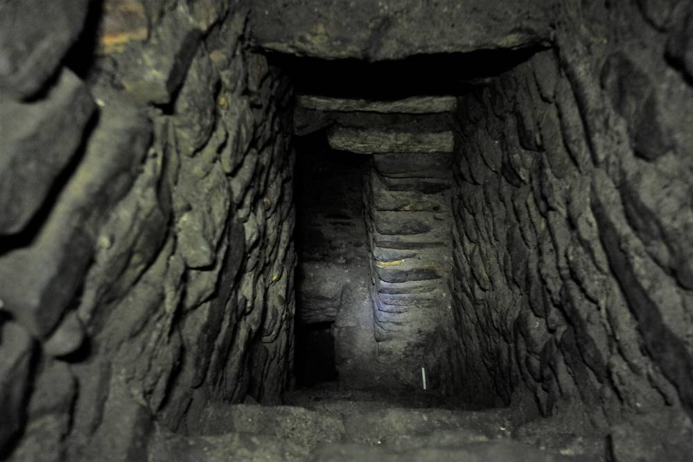
Part of an area is pictured, where archaeologists of the National Institute of Anthropology and History (INAH) found remains that reveal cremation rites for Mayan rulers at Tonina pyramid, in Ocosingo, Chiapas state, Mexico. — Handout by INAH via Reuters
Inside the chamber, discovered in 2020 and likely built between the 7th and 8th centuries, archaeologists found 400 vessels containing human ashes mixed with rubber and roots.
The findings support archaeologist Juan Yadeun’s hypothesis that important figures’ remains were incorporated into balls used in sport — “a transformation of the body” that allowed them to live on after their death.
“Such discoveries in Tonina provide a more accurate idea of how interesting and complex the Mayan religion was,” Yadeun said. — Reuters

Part of an area is pictured, where archaeologists of the National Institute of Anthropology and History (INAH) found remains that reveal cremation rites for Mayan rulers at Tonina pyramid, in Ocosingo, Chiapas state, Mexico. — Handout by INAH via Reuters
Footprints Discovery Suggests Ancient ‘Ghost Tracks’ May Cover the West
Scientists have discovered ancient human footprints in Utah, traces, they say, of adults and children who walked barefoot along a shallow riverbed more than 12,000 years ago.
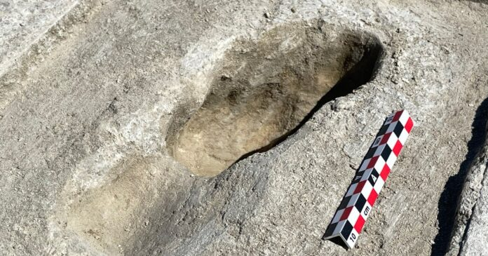
It took “pure chance” to make this discovery at the Utah Test and Training Range, a 2.3-million-acre site where the U.S. Armed Forces test experimental aircraft and other military hardware, said Tommy Urban, a research scientist at Cornell University. Following on Dr. Urban and his colleagues’ recent studies of ancient human and other mammal tracks at White Sands National Park in New Mexico, the Utah tracks extend scientific understanding of ancient North America by revealing not just the existence of a diversity of animals and humans, but also evidence of their behaviors.
Daron Duke, a Nevada-based archaeologist for the Far Western Anthropological Research Group, invited Dr. Urban to assist with a search for ancient campfires at the Utah test range. Dr. Duke and his team published a paper on the contents of one campsite last year.
While driving to a dig site, the two were having an animated conversation about trackways. When Dr. Duke asked what a fossil footprint looked like, Dr. Urban pointed out the window and said, “Well, kind of like THAT!” They stopped the truck, having located the first of what would turn out to be 88 footprints.
“When I spotted them from the moving vehicle, I didn’t know they were human,” Dr. Urban said. “I did know they were footprints, however, because they were in an evenly spaced, alternating sequence — a track pattern.”
The 88 footprints are in several short trackways, some of which indicate that people may have simply been congregating in one area. “It doesn’t look like we just happened to find someone walking from point A to point B,” Dr. Duke said. They believe these footprints are of people who lived nearby. “Maybe collecting things. Maybe just enjoying themselves” in the shallow water, he added.
Dr. Duke said they had also found a type of stone spear tip in a nearby site that might have been used to hunt large animals, but no evidence of the animals yet.
Dr. Urban compared the Utah footprints to the “ghost tracks” in White Sands, a term used for tracks that appear only under certain conditions, then disappear just as quickly. The fossil tracks in New Mexico, as much as 23,000 years old, were uncovered using ground-penetrating radar technology and contained a treasure trove of revelations: tracks of ancient humans and megafauna intersecting and interacting with each other. They showed proof that ancient humans walked in the footprints of enormous proboscideans and vice versa; that one human raced across the mud holding a child, put that child down at one point, picked that child back up and then rushed off to an unknown destination; that at least one giant ground sloth was followed by ancient humans, rose up on its hind legs and twirled as the humans surrounded it; that children played in puddles.
The discovery of the additional set of tracks in Utah suggests that there are other sites around the United States where more about ancient human behavior waits to be revealed.
“The western U.S. has many similar settings that could have early footprint sites,” Dr. Urban said of the salt flats. He added, “Now we have a second location, there are probably more out there.”
Still, finding human footprints was surprising. Humans haven’t inhabited the area for thousands of years. It’s a desert, it’s remote and it’s a military installation.
“When we thought through these options, concluding that the most logical explanation is that the footprints were made during the late Pleistocene, then we were excited,” Dr. Urban said.
The Utah footprints are more than what appears on the surface.
“They are subtle, because they are flush with the ground surface and generally covered in a veneer of the same sediment,” Dr. Urban said. “You wouldn’t necessarily notice them if you didn’t already know what to look for.”
When footprints are made, the pressure of the tracks impacts the subsurface, offering information about the weight and size of the people or animals making those tracks, as well as the speed at which they are moving. By studying them with ground-penetrating radar, the team was able to find additional footprints and understand more about the tracks without destroying them.
Dr. Urban and his teammates taught Dr. Duke how to carefully excavate some of the tracks. It was Dr. Duke’s first time working with footprints, and he admitted to feeling trepidation about excavating them. But, he said, “when you see the children’s toes forming in what you’re digging, that’s just amazing.”
The staff at Hill Air Force Base, which administers the range, has worked to include and inform Native American communities about the discovery.
“I’ve now known for about three weeks, and I have to admit, I’m still processing because it is a once-in-a-lifetime find,” said Anya Kitterman, an archaeologist overseeing Dr. Duke and his colleagues’ work on behalf of the Air Force at the test range. “There’s something so personal about the footprints and being able to walk alongside these trackways knowing that someone years ago walked right there.”
Patty Timbimboo-Madsen, a Shoshone tribal member and cultural and natural resource manager for the Northwestern Band of Shoshone, said she couldn’t miss the opportunity to visit the tracks.
“It gives us proof that our people were here,” she said. “And I think our people have always been here.”
Ms. Kitterman says the Air Force is now considering how to manage the discovery site. “We’re still learning this landscape and what these trackways mean,” she said. “How do we preserve them?”
And if the Utah test range site is anything like what was found at White Sands, preserving the site could be worth the trouble, because the researchers think there will be so much more to learn.
Conquistadors sacrificed and eaten by Aztec-era people, archaeologists say
Researchers say evidence shows Acolhuas, allies of a major Aztec city known to have captured a Spanish convoy in 1520, killed and cannibalised their captives
Aztecs under attack: Hernán Cortés, with 200 Spaniards and 5,000 Indians defeats a larger Aztec force in 1520. Photograph: Unknown/ Archivo Iconografico, S.A./CORBIS
Spanish conquistadors, women, children and horses were imprisoned for months, sacrificed and eaten by contemporaries of the Aztecs, archaeologists report after unveiling new research from ruins near Mexico City.
Although Spanish chroniclers including Hernán Cortés, who led the conquest of Mexico in 1520, recorded the capture of a convoy that year, archaeologists are for the first time uncovering details of what happened when a native people first encountered the Spanish, Mexico’s National Institute of Anthropology and History said in an announcement of its findings.
Only a few dozen miles from the relative safety of the Spanish army, the convoy of conquistadors and allies encountered a local people known as the Acolhuas, allies of Tetzcoco, a major Aztec city.
Somehow, the caravan – archaeologists estimate it included 15 Spaniards, 45 soldiers from the colonies, 50 women, 10 children and a large number of indigenous allies – was captured. Over the next six months, its members met a grisly end.
Traces of construction show that the Acolhuas had to remake Zultepec, a town just east of the capital, then called Tenochtitlan, to accommodate the prisoners, archaeologist Enrique Martinez said in a statement.
The town was eventually renamed from Zultepec to Tecoaque, which in the native Nahuatl language means: “The place where they ate them.”
The Acolhuas housed the prisoners in ad hoc cells, where archaeologists found the remains of the caravan members with signs that they had been sacrificed. Every few days, Martinez said, the priests chose someone to kill, sometimes in the town square, sometimes in their cell and within earshot of the others.
The archaeologists said the townspeople sacrificed people in honor of the serpentine fertility god Quetzalcoatl, the jaguar god Tezcatlipoca and the aquiline warrior god Huitzilopochtli.
“Different deities needed different sacrifices,” Rosemary Joyce, a professor of anthropology at the University of California, Berkeley, told the Guardian.
“It was traditional in the back and forth between the Aztecs [and contemporaries] to sacrifice people who were captured, specifically warriors.”
Women and children were also chosen, said Joyce, who was not involved in the excavations. “Children in particular were selected for rain deities.”
Clay figurines, some represented in European-looking garb, are among the 15,000 artifacts unearthed from the site. They likely played a role in rituals, Martinez told the Associated Press. “We have figurines of blacks, of Europeans, that were then intentionally decapitated.”
Lisa Overholtzer, a McGill University anthropologist who has studied similar figurines, expressed skepticism about the the artifacts, saying that despite their trappings “there is nothing that clearly indicates the individual is Spanish”.
But if the figurines are dated to 1520, she said, “it would represent perhaps the earliest appearance of this kind of figurine, in a period when racial categories were still in flux”.
One miniature sculpture resembles something not quite human, and instead has “an angel’s face on one side and a demon with goat horns on the other”, the researchers said.
Sacrifice was not the end for the victims. Skeletons show the marks of cuts consistent with flesh cleaved from bones, Martinez said, suggesting that the townspeople ate not just the horses but the caravan travelers as well.
Martinez could not be reached to describe evidence of cannibalism, however, and other archaeologists cautioned that such claims were sometimes founded in colonists’ accounts and not always supported by material evidence.
Some of the human remains were placed around the site, as on a bone rack of skulls that later greeted the avenging Spaniards sent by Cortés. In another case, inside the pelvis of a woman who was sacrificed and dismembered in a plaza, the Acolhuas placed the skull of a one-year-old child.
Only the pigs were spared the full treatment, apparently because they so baffled the native people.
“The pigs were sacrificed and hidden in a well, but there is no evidence they were cooked,” Martinez said.
When Cortés learned of the massacre he sent a force to destroy the town and the Acolhuas. Martinez said the ruins of Zultepec-Tecoaque suggest its inhabitants tried to quickly abandon and hide evidence of the sacrifices by tossing the Europeans’ belongings in certain rooms and in cisterns.
Archaeologists have found more than 200 objects, including a riding spur, a brooch, rings, iron nails and glazed ceramic figurines, in 11 cisterns around the site, and plan to explore three more in the coming months.
Cortés’ soldiers destroyed the town, but Acolhuas’ attempt to bury remnants of the sacrifices actually helped preserve the evidence for later archaeologists, Martinez noted.
The identification of indigenous allies in the Spanish caravan struck Overholtzer as a telling sign of the complex world into which the invaders marched.
“The Spanish were able to ultimately conquer the Aztec capital of Tenochtitlan not because of guns or steel,” she said, “but because of their fierce, skilled indigenous warrior allies.”
Martinez argued that the findings showed that indigenous people fought back against the conquistadors, in contrast to the popular story that Mesoamerican peoples ceded to the Spanish quickly.
But betrayal was a way of life as much in the Americas as in Europe in the 16th century, University of Florida archaeologist Susan Gillespie said, and: “Cortés learned of, and exploited, these political rifts to his advantage.”
By the time the conquistador laid a final siege on the Aztec capital, the Acolhuas had allied themselves with Spain.
Ancient Maya installed gemstones in their teeth. It wasn’t just fashion.
The ancient Maya enjoyed filling their teeth with gemstones. A new study reveals how the procedure was done and how it didn't kill them.

The Maya once installed gemstones in their teeth as a fashion statement that might also have had medicinal benefits.
The dental procedure appears to have been surprisingly common, and its practitioners managed to do it without killing the patient.
A recent study suggests elements of the cement used to hold the stone in place may have kept infection and cavities at bay.
The ancient Maya civilization has long intrigued the modern world because of its impressive cities and temples, its invention of the concept of zero, and its sudden and mysterious collapse. But among the lesser-known aspects of Maya society was a tendency for citizens to decorate their teeth with gemstones directly inlaid into the enamel.
A study recently published in the Journal of Archaeological Science: Reports found that this procedure may have been more common than previously thought, and that the Maya were surprisingly skilled at the dental procedure.
More than just bling
A thousand years before Pierre Fauchard began his work on replacing lost teeth with ivory dentures in France or the introduction of grillz into parts of popular culture, the Maya were both taking excellent care of their teeth through regular cleaning and filling their teeth into pointed shapes for what were long presumed to be ritual reasons. They were also placing semiprecious stones into their teeth as seen below:

The eight Maya teeth used in the study. (Hernández-Bolio et al., Journal of Archaeological Science: Reports, 2022)
While these samples can seem a little dull, a wide variety of gems have been found in teeth from burial sites, including jadeite, iron pyrites, hematite, turquoise, quartz, serpentine, and cinnabar. The visual effect would have been vibrant during the lifetime of the person who had the surgery done.
Getting a gemstone in the middle of your incisor is a bit more complicated than a filling. These inlays require digging deep openings into the surface of the tooth, setting a stone into it, and sealing it in place. This can lead to irritation at best and pulp necrosis and apical periodontitis at worst if done improperly.
Learning how they managed to carry out this surgery was one of the key motivations for this new study. Eight teeth from sites known to have been part of the Lowland Maya culture were selected for the large amount of sealant still present on them. The teeth all date back to the first millennium.
How to prevent cavities before toothpaste
The stones did not stay in place with mere glue. The cement the Maya used was a complex mixture that most likely also had medicinal benefits. Pine resin, found in some of the samples, is thought to have a number of antimicrobial qualities. Two of the skeletons had hints of sclareolide, a product used in cosmetics and often found in clary sage and tobacco. This substance has antifungal and antibacterial traits and could bestow these benefits into the cement as well. Oils from plants related to mint were also detected, which could bestow anti-inflammatory effects when used in this way.
While the different skeletons had different cement compounds, the overall effect of the components in the cement appears to be similar: The concoction may have offered some protection against cavities and the side effects of the surgery. Plus, the cement has lasted 1,000 years and continues to hold the stones in place.
The authors concluded that:
“The analyses conducted on dental sealings from the Maya lowlands demonstrate the rich blend of organic components in the production of ancient dental cements. Our study confirms that these were not merely agglutinants. Rather, as anticipated by Fastlicht, the Maya developed complex recipes for their dental cements to produce adhesives that not only preserved for over a millennium but likely provided hygienic and therapeutic properties.”
The study also noted that none of the remains appear to be those of royals, and most of them appear to belong to members of middling socioeconomic classes. This suggests that the procedure was common and not limited to the elite — though as many as one in three elite males may have had the procedure done. The three sites in the study were all of what we now consider the Maya culture, but were spread across what is now Guatemala, Belize, and Honduras, suggesting that knowledge of how to use these plant materials spread with the tendency to alter teeth in this way.
Although the findings are unlikely to bring gemstone dental inlays back into fashion, they do highlight how common this complex procedure once was, why it worked, and yet another way the cleverness of the Maya expressed itself.