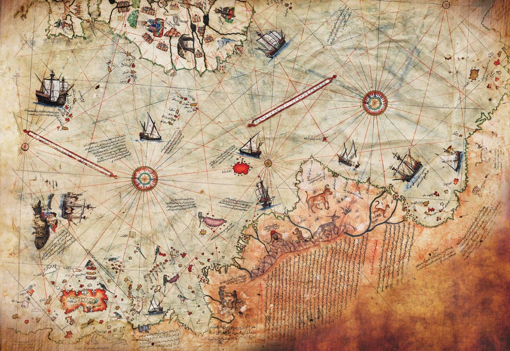
The Piri Reis Map is one of the most famous and beautiful fragments of cartography from the Age of Discovery. Drawn on gazelle skin in 1513 by the Ottoman admiral, geographer, and cartographer Ahmed Muhiddin Piri (better known as Piri Reis), the map compile-synthesized dozens of older charts to map the Atlantic Ocean, the western coasts of Europe and Africa, and the newly discovered eastern coast of South America.
In alternative history circles—popularized by author Erich von Däniken in the 1960s and more recently by Graham Hancock—the map is presented as a profound mystery. They claim that the bottom portion of the map illustrates the Queen Maud Land coast of Antarctica completely free of ice.
Because Antarctica was not officially discovered until 1820, and its sub-glacial coastline has been frozen for millions of years, these authors argue the map proves that an advanced, prehistoric global civilization mapped the planet during the last Ice Age.
However, when historians, geographers, and cartographers actually analyze the map, the mystery vanishes. The true story of the Piri Reis map does not rely on ancient anomalies, but rather on the standard practices of 16th-century mapmaking, geographic distortion, and a heavy reliance on Christopher Columbus.
1. The Core Claim: The Sub-Glacial Coastline
The theory that Piri Reis mapped an ice-free Antarctica relies heavily on the work of Charles Hapgood, an American college professor who published Maps of the Ancient Sea Kings in 1966. Hapgood claimed that the landmass curving out from the bottom of South America matched the coastline of Queen Maud Land, Antarctica, with shocking seismic accuracy.
To alternative theorists, this layout implies:
The map must be based on source charts dating back to a time when Antarctica was free of ice ($10,000\text{ BCE}$ or earlier).
The creators must have possessed advanced spherical trigonometry to map the earth from an aerial projection point.
2. The Cartographic Reality: Terra Australis Incognita
To understand why the Piri Reis map features a massive landmass at the bottom, one must look at the intellectual mindset of Renaissance cartographers. They were not working with satellite data; they were working with a mixture of raw exploration data and classical Greek philosophy.
the Law of Geometric Balance
Ever since the time of Aristotle and Ptolemy, European and Middle Eastern geographers believed in a concept known as Terra Australis Incognita (the Unknown Southern Land).
The Greeks argued that the world was a sphere that required perfect geometric balance. Because they knew there was a massive weight of landmasses in the Northern Hemisphere (Europe, Asia, Africa), they logically deduced that there must be an equally massive, heavy continent at the bottom of the globe to act as a counterweight. If this southern continent did not exist, they believed, the Earth would literally capsize and tip over in space.
As a result, almost every mapmaker of the 15th and 16th centuries drew a hypothetical, sprawling landmass at the bottom of their charts. They did not need to see it or survey it; their philosophy dictated that it had to be there.
3. The Structural Error: South America Curved
When we strip away the theoretical "Antarctica" label and look closely at the annotations written in Ottoman Turkish on the map itself, a much simpler, more accurate explanation emerges: The bottom of the map is just the lower half of South America, bent sideways to fit the shape of the gazelle skin.
   [ BRAZILIAN COASTLINE ] ───► Continues Down toward Patagonia
                                          │
                             (The Animal Skin Limit)
                                          │
                                          ▼
   [ DISTORTED 90° CURVE ] ───► Bent Eastward along the bottom edge of the parchment
Piri Reis was painting on a precious, limited piece of parchment made from a single gazelle skin. As he mapped the newly discovered coastline of Brazil moving southward, he ran out of physical space at the bottom of the skin.
Rather than stitching on a new piece of leather, he followed a common practice of his era: he distorted the coastline, bending the tip of South America (modern-day Argentina and Patagonia) sharply to the right at a 90-degree angle to run along the natural margin of the parchment.
The Textual Proof
The proof of this distortion is written right on the map. Piri Reis filled his chart with extensive notes explaining his sources. In the text blocks pinned to that controversial "Antarctic" landmass, he mentions that the region is exceptionally hot and filled with large snakes, monstrous beasts, and parrots. This description fits the tropical and subtropical climate of South America perfectly, but it completely rules out a sub-glacial or cold polar landscape.
4. The Columbus Connection
The true historical value of the Piri Reis map lies not in a lost Ice Age civilization, but in the fact that it preserves the lost first-voyage maps of Christopher Columbus.
Columbus’s original personal charts that he drew during his 1492 journey to the Caribbean were lost to history. However, in 1501, Ottoman sailors captured a Spanish ship in the Mediterranean. Inside the ship’s cabin, they found a pilot who had sailed with Columbus, who happened to be carrying copies of Columbus’s original charts.
   [ COLUMBUS'S 1492 VOYAGE ] ──► Original Maps Drawn ──► Lost to European History
                                                                │
                                                    (The Ottoman Interception)
                                                                │
                                                                ▼
   [ PIRI REIS COMPILATION ] ◄─── Copied from captured Spanish Pilot's charts (1501)
Piri Reis explicitly notes on his map that he used "the map of Colombo" to construct the western Caribbean portion of his chart. This explains why the Caribbean section features unique historical errors—such as depicting the island of Cuba as part of the mainland continent, which matches Columbus’s mistaken, lifelong belief that he had reached the coast of Asia.
5. Summary of the Cartographic Analysis
The Myth: A 1513 Ottoman chart showing the sub-glacial, ice-free coastline of Antarctica, proving prehistoric high-technology mapping.
The Material Constraint: A 90-degree distortion of the Patagonian South American coastline, bent eastward to fit the physical boundary of a single piece of gazelle hide.
The Ideological Driver: The insertion of Terra Australis Incognita—a theoretical southern continent invented by Greek philosophers to act as a weight counterweight for the globe.
The Historical Value: The preservation of Columbus’s earliest, otherwise-lost navigation charts of the Caribbean and the New World.
The Piri Reis Map remains one of the greatest triumphs of Renaissance geography. By stripping away the pseudo-scientific myths of ancient astronauts or prehistoric mapping lasers, we expose a far more realistic and human wonder. The map shows an brilliant Ottoman admiral sitting in Constantinople, meticulously weaving together captured Spanish charts, Portuguese navigation logs, and ancient Ptolemaic geometry to make sense of a world that was expanding faster than anyone could comprehend. It is an enduring monument to an era when human beings were boldly charting the edge of the unknown using nothing but courage, ink, and a profound curiosity about the shape of the earth.