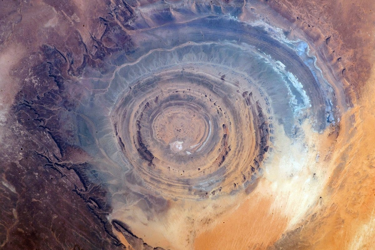
Deep in the windswept deserts of west-central Mauritania sits the Richat Structure, globally recognized as the "Eye of the Sahara." Looking from space, this jaw-dropping geological anomaly resembles a colossal, 40-kilometer-wide ($25\text{-mile}$) bulls-eye or concentric ring network carving directly into the desert floor.
In recent years, the Richat Structure has exploded in popularity across digital media platforms as the supposed physical location of Atlantis, the legendary lost civilization chronicled by the Greek philosopher Plato around 360 BCE. Proponents of this theory point to a series of stunning visual and structural correlations that seem too precise to be mere coincidence.
However, when historians, classicists, and structural geologists analyze the site, the "Atlantis epicenter" theory completely evaporates. The true narrative of the Eye of Sahara does not rely on a sunken maritime empire, but rather on the deep time scales of tectonic magmatism, continental rifting, and selective dome erosion.
1. The Atlantean Argument: Plato’s Blueprint in the Sand
The modern resurgence of the Richat-as-Atlantis theory relies heavily on comparing the physical geography of Mauritania with the literal text of Plato’s dialogues, Timaeus and Critias. Proponents match several key descriptions:
The Concentric Rings: Plato described Atlantis as a city built out of alternating, concentric zones of water and land—specifically, three rings of water and two of land. From an aerial view, the Richat Structure displays an identical concentric ring footprint.
The Scale and Dimensions: Plato stated that the outer ring of Atlantis measured 127 stadia in diameter. When converted to modern metrics, this equals roughly 23.5 kilometers—a measurement that matches the inner core rings of the Richat anomaly.
The Northern Mountains and Southern Plain: Plato noted that the city was sheltered to the north by grand, sweeping mountains noted for their beauty, while opening up to the south into a vast, rectangular agricultural plain. Satellite imagery shows the rugged Atlas and Mauritanian mountain ridges bounding the Richat to the north, sloping down into a vast desert basin to the south.
The Colors of the Stone: The dialogues mention that the architects of Atlantis quarried stone that was black, white, and red to construct their monumental palaces. Geologists confirm that the rock strata of the Richat feature black basalts, white limestones, and red iron-rich volcanic breccias.
2. The Geological Reality: The Sinking of a Magmatic Dome
Despite these visual coincidences, mainstream geologists—who have mapped the Richat Structure using field geochemistry, aeromagnetic surveys, and satellite radar—have definitively proven that the structure is completely natural. It is not a excavated city, but a highly unique geological feature known as a deeply eroded alkaline magmatic dome.
Its formation began roughly 100 million years ago during the Cretaceous period, coinciding with the violent breakup of the supercontinent Pangea and the opening of the Atlantic Ocean.
Step 1: The Magmatic Uplift
Deep beneath the Earth's crust, a massive plume of superheated magma forced its way upward into the overlying flat sheets of sedimentary sandstone and limestone. The magma never erupted onto the surface to form a traditional volcano. Instead, it acted like a giant underground piston, pushing the flat surface rock layers upward from below to create a massive, circular blister or dome on the landscape.
Step 2: Hydrothermal Alteration and Collapse
As the magma cooled slowly over millions of years, highly reactive, mineral-rich hydrothermal fluids surged through the cracks in the dome. These fluids chemically dissolved and weakened the internal limestone core of the structure. Deprived of its underlying support, the center of the dome suffered a massive structural collapse, dropping straight down to form a vast central depression.
Step 3: Differential Weathering
Once the dome collapsed, tens of millions of years of wind, rain, and desert sandstorms went to work on the exposed edges of the rock layers. Sandstone is exceptionally hard and resistant to erosion, while limestone and shale are soft and easily hollowed out by the elements.
   [ HIGH-DENSITY MAGMA PISTON ] ──► Pushes Flat Sandstone Layers Upward into a Dome
                                                │
                                   (The Deep Time Weathering)
                                                │
                                                ▼
   [ CONCENTRIC RING RIDGE LINES ] ◄── Hard Sandstone Remains / Soft Limestone Erodes Away
As erosion stripped away the top of the dome, the hard sandstone layers remained standing as high, prominent concentric ridges, while the softer rock layers were swept away entirely, carving out the deep concentric valleys between them. This process of differential weathering manufactured the flawless circular "steps" that alternative theorists mistake for man-made concentric rings.
3. The Flaws in the Myth: Altitude and Archaeology
When the site is evaluated using standard historical method and archaeological science, the Atlantis theory suffers from critical errors:
1. The Altitude Conflict
Plato’s central premise is that Atlantis was an international maritime empire—a low-lying naval power whose canals opened directly into the Atlantic ocean, allowing triremes and merchant ships to sail deep into the city's heart.
The Richat Structure sits at an average altitude of 400 meters ($1,300\text{ feet}$) above sea level and is located more than 500 kilometers ($300\text{ miles}$) inland from the modern Atlantic coast. While the Sahara was considerably greener in the deep past, geophysical mapping confirms that the Richat plateau was never submerged beneath the ocean during any period of human history. Ships could never have sailed into its rings.
2. The Complete Absence of Artifacts
If the Richat were truly the thriving, high-technology capital of a global empire that controlled the western Mediterranean, the soil should be thick with the indestructible trash of human civilization: thousands of tons of metal slag, brick kilns, glass fragments, domestic refuse heaps, and structural foundations.
Instead, extensive archaeological surveys across the Richat have recovered only two types of human materials:
A scattered collection of Acheulean stone handaxes and scraping tools dating back hundreds of thousands of years, dropped by early hominids (Homo erectus).
Scattered Neolithic arrowheads and spear points left behind by nomadic hunter-gatherers around 4,000 BCE.
There is an absolute, multi-millennial void of any permanent masonry, plumbing, metallurgy, or urban settlement infrastructure.
4. Summary of the Richat Anomaly
The Sensation: A theory framing the Eye of the Sahara as the literal epicenter of Plato's Atlantis due to its matching concentric rings, mountain boundaries, and stone color palettes.
The Geomorphology: A 40-kilometer-wide alkaline magmatic dome created 100 million years ago by subterranean magma pressure during the rifting of Pangea.
The Structural Mechanics: Tens of millions of years of differential weathering, where hard sandstone beds resisted erosion to form high ridges, while soft limestones washed away to form concentric ring trenches.
The Archaeological Verdict: Total absence of urban masonry, metals, or domestic infrastructure; the site is situated 400 meters above sea level, making historical maritime ship access physically impossible.
The Richat Structure stands as one of the greatest natural wonders of our planet. By removing the speculative veil of alternative myths, we reveal a far grander scientific truth. The Eye of the Sahara is not a sunken monument to human hubris, but a pristine, open-air laboratory displaying the staggering tectonic forces that tear continents apart and reshape the crust of the earth over deep time. Looking down into its colossal stone rings is not a glance into a forgotten human history, but a profound window into the majestic, patient architecture of the Earth itself.