• MAIN PAGE
  • LATEST NEWS
    • Lost Cities
    • Archaeology's Greatest Finds
    • Underwater Discoveries
    • Greatest Inventions
    • Studies
    • Blog
  • PHILOSOPHY
  • HISTORY
  • RELIGIONS
    • Africa
    • Anatolia
    • Arabian Peninsula
    • Balkan Region
    • China - East Asia
    • Europe
    • Eurasian Steppe
    • Levant
    • Mesopotamia
    • Oceania - SE Asia
    • Pre-Columbian Civilizations of America
    • Iranian Plateau - Central Asia
    • Indus Valley - South Asia
    • Japan
    • The Archaeologist Editor Group
    • Scientific Studies
    • Aegean Prehistory
    • Historical Period
    • Byzantine Middle Ages
    • Predynastic Period
    • Dynastic Period
    • Greco-Roman Egypt
  • Rome
  • PALEONTOLOGY
  • About us
Menu

The Archaeologist

  • MAIN PAGE
  • LATEST NEWS
  • DISCOVERIES
    • Lost Cities
    • Archaeology's Greatest Finds
    • Underwater Discoveries
    • Greatest Inventions
    • Studies
    • Blog
  • PHILOSOPHY
  • HISTORY
  • RELIGIONS
  • World Civilizations
    • Africa
    • Anatolia
    • Arabian Peninsula
    • Balkan Region
    • China - East Asia
    • Europe
    • Eurasian Steppe
    • Levant
    • Mesopotamia
    • Oceania - SE Asia
    • Pre-Columbian Civilizations of America
    • Iranian Plateau - Central Asia
    • Indus Valley - South Asia
    • Japan
    • The Archaeologist Editor Group
    • Scientific Studies
  • GREECE
    • Aegean Prehistory
    • Historical Period
    • Byzantine Middle Ages
  • Egypt
    • Predynastic Period
    • Dynastic Period
    • Greco-Roman Egypt
  • Rome
  • PALEONTOLOGY
  • About us

Bones preserved for L522.1 (a) ovicaprid bones from within L522.1's burial vessel (b) reconstruction of burial L522.1

Two rare 5th millennium BC fetal burials in Iran reveal variable prehistoric practices

February 2, 2026

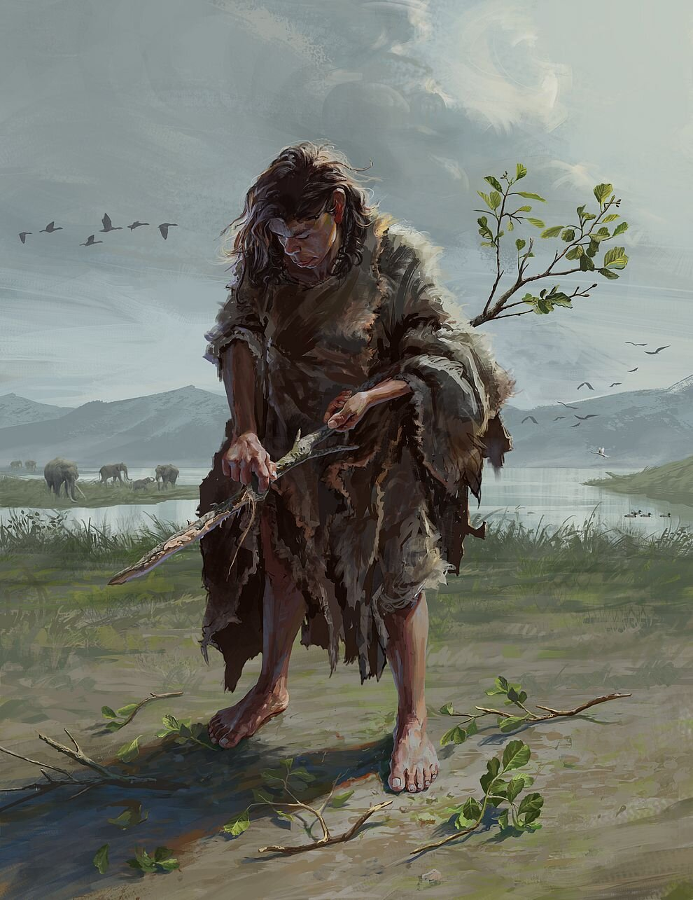
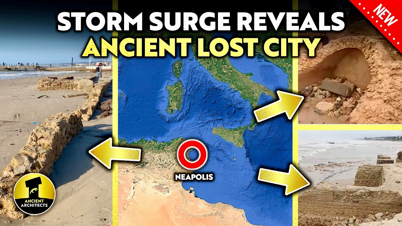
A study by Dr. Mahdi Alirezazadeh and Dr. Hanan Bahranipoor, published in Archaeological Research in Asia, presents the analysis of two exceptionally well-preserved fetal burials from Chaparabad, Iran, dating to the mid-5th millennium BC. Among them is burial L522.1, one of the most complete prehistoric infant burials ever documented on the Iranian Plateau. Although the two fetuses were buried only a few meters apart, they exhibit markedly different burial treatments, offering valuable insight into the diversity of prehistoric mortuary practices in southwestern Asia.

Fetal burials

Fetal burials are occasionally encountered during archaeological excavations but remain relatively rare in the archaeological record due to poor preservation conditions. Nevertheless, evidence of fetal burial practices has been documented from the Neolithic through the Chalcolithic periods across Southwest Asia, including the Fertile Crescent and the Central Plateau of Iran.

Excavations at Chaparabad conducted between 2021 and 2023 uncovered two fetal vessel burials, designated L522.1 and L815.1. Both were located within an architectural space measuring approximately 310 square meters. Burial L522.1 was recovered from Structure D, interpreted as a kitchen, while L815.1 was found in a space likely used for storage. In both cases, the fetuses were interred in ceramic vessels associated with the Dalma culture of the early 5th millennium BC.

“The burial vessels appear to have been previously used for everyday domestic activities,” explains Dr. Alirezazadeh. “For instance, the vessel associated with L522.1 is a Red Slip Ware typical of the Dalma cultural tradition, and smoke staining on its exterior indicates it had likely been used for cooking.”

Together with other ceramics from the site belonging to both the Dalma and the Pisdeli (late 5th millennium BC) cultures, the evidence suggests that the burials occurred during a period when both cultural traditions were contemporaneously active in the region.

Skeletal analysis and burial treatment

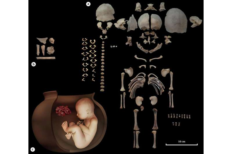
The exceptional preservation of the remains—particularly burial L522.1, for which approximately 90 percent of the skeletal elements were recovered—allowed for detailed quantitative and qualitative analyses. Based on bone fusion and long bone measurements, both fetuses were estimated to have died between 36 and 38 weeks of gestational age.

No clear signs of trauma were identified, with the exception of a fracture to the right parietal bone of L522.1. Given the positioning of the skull near the rim of the vessel, researchers concluded that the fracture most likely resulted from soil pressure during or after burial rather than perimortem injury.

Despite their close spatial proximity and similar developmental age, the two burials differed significantly in treatment. Burial L522.1 was accompanied by grave goods, including ovicaprid (sheep or goat) remains placed both inside the vessel near the rim and beneath it, as well as a worked stone found nearby. In contrast, L815.1 contained no grave goods and was buried outside the kitchen area, within a storage space.

According to Dr. Alirezazadeh, this contrast reflects broader regional patterns of variability in fetal and infant burial practices during the Dalma and Pisdeli periods. Archaeological parallels demonstrate wide-ranging approaches to burial vessels and grave goods. At Chagar Bazar in Syria, fetal burials used vessels ranging from weaning bowls to miniature pots, while at Tell as-Sawwan, burials were typically sealed with inverted bowls and ceramic fragments. Grave goods also varied considerably: a fetus at Girdi Sheytan was buried with stone beads, three copper axes accompanied a burial at Ovçular Tepesi, and at Yarim Tepe—near the Dalma cultural sphere—all 14 known fetal burials lacked grave goods entirely.

This variability is mirrored at Chaparabad. “The two burials were discovered less than three meters apart and belong to the same chronological horizon,” Dr. Alirezazadeh notes. “This allows us to rule out explanations based on broader cultural differences or social hierarchy.”

However, he emphasizes the limitations of interpretation: “We did not live within these communities, and therefore cannot state with certainty why one infant received burial goods while the other did not. Our conclusions are necessarily constrained by the available data, and further research will be required.”

Ongoing DNA and stable isotope analyses may provide additional insights into kinship, health, and social practices. Overall, the Chaparabad fetal burials highlight the complexity of prehistoric mortuary behavior and underscore the cultural significance attributed to fetal individuals in Chalcolithic societies of the Iranian Plateau.

An artist’s reconstruction of a Marathousa 1 paleolithic woman producing a digging stick from a small alder tree trunk with a small stone tool. This kind of wood was used for the Marathousa 1 digging stick. Usewear analysis of stone tools at Marathousa 1 show evidence of woodworking.

Earliest hand-held wooden tools found in Greece date back 430,000 years

February 2, 2026

An international research team has identified the earliest known hand-held wooden tools used by humans, dating back around 430,000 years. The discovery comes from the Marathousa 1 archaeological site in central Greece’s Peloponnese and is described in a study published in PNAS, jointly led by Professor Katerina Harvati of the University of Tübingen and Dr. Annemieke Milks of the University of Reading.

The findings include two deliberately shaped wooden objects—one made from alder and the other from willow or poplar—representing the oldest hand-held wooden tools ever discovered. This pushes back evidence of such tool use by at least 40,000 years, significantly expanding understanding of early human technology.

The site, which was once located along the shore of a lake, also yielded stone tools and the remains of an elephant and other animals, suggesting it served as a butchering location. Early humans occupied the area during the Middle Pleistocene period, a crucial phase in human evolution marked by increasingly complex behaviors.

“The Middle Pleistocene was a critical phase in human evolution, during which more complex behaviors developed,” said Professor Harvati. “The earliest reliable evidence of targeted technological use of plants also dates from this period.”

The discovery highlights the importance of perishable materials like wood—rarely preserved in the archaeological record—in shaping early human survival strategies and technological innovation.

The functional end of 940/673-39, View 3. The pink highlighted area shows where the wood fibers show micro-damage, likely from use.

Worked stone tools and bone artifacts from the site had already demonstrated the technical skill and wide range of activities practiced by the people who once lived there, prompting researchers to examine the associated wooden finds more closely.

“Unlike stone, wooden objects require very specific conditions to survive over long periods of time,” explained Dr. Annemieke Milks, a leading specialist in early wooden tools. “We carefully examined all wooden remains under microscopes and identified chopping and carving marks on two objects—clear evidence that they had been deliberately shaped by early humans.”

Meticulous examination

The research team identified two wooden artifacts that showed unmistakable signs of human modification. One was a small piece of alder trunk bearing clear shaping marks as well as wear traces, suggesting it may have been used for digging along the lake’s edge or for stripping bark from trees.

The second artifact, a very small fragment made from willow or poplar, also showed signs of deliberate working and possible use. A third find—a larger piece of alder wood marked with a grooved pattern—was initially considered a potential tool, but closer analysis revealed that the marks were likely caused by the claws of a large carnivore, possibly a bear, rather than by human activity.

Together, the findings highlight both the sophistication of early human tool-making and the importance of rare wooden artifacts in reconstructing ancient behavior.

What Archaeologists Won’t Admit About Bulgaria’s Megaliths

February 1, 2026

Bulgaria’s Mysterious Stone Megastructures: Secrets of Europe’s Ancient Past

Bulgaria is home to some of the most enigmatic stone structures in Europe, places that continue to puzzle archaeologists, historians, and explorers alike. From entire mountains carved into sacred cities to cliffside reliefs etched high above the ground, these ancient sites push the limits of what we thought early civilizations could accomplish.

In this documentary, we explore a series of Bulgaria’s most mysterious locations: Perperikon, Belintash, Tatul, Beglik Tash, Sveshtari, Mezek, Pliska, and the Madara Rider. Each site raises questions that challenge conventional historical timelines:

  • Who built them?

  • How were such massive and precise constructions achieved?

  • Could their origins stretch far deeper into the past than written history records?

From ceremonial centers and fortresses to astronomical alignments and cliff carvings, these structures reflect a level of skill, planning, and spiritual purpose that hints at lost knowledge and forgotten cultures. Some scholars suggest that Bulgaria may have been home to advanced societies whose stories have been partially erased from history, leaving only these enduring stone monuments as clues.

These sites are more than archaeological curiosities—they are a reminder that Europe’s ancient past is far richer, stranger, and more mysterious than textbooks often admit. Exploring them is like stepping into a world where myth and history collide, where every stone carved and every relief etched tells a story older than we can fully comprehend.

Watch the video below to journey through Bulgaria’s stone megastructures and uncover the secrets of these ancient wonders:

5 Most Massive Unexplained Ancient Walls

February 1, 2026

Derbent and the Gates of Alexander: The Wall That Stopped Empires

In a forgotten corner of southern Russia, a massive stone wall cuts through a modern city, stretching from the mountains all the way to the Caspian Sea. Beneath it lies a secret older than empires—a gate long believed to hold back the end of the world.

Legends claim that Alexander the Great built it to seal away monstrous tribes foretold in prophecy. Others suggest it marks the line between civilization and chaos. Yet here, in Derbent, the so-called Gates of Alexander are not myth. They are real, colossal, and remarkably preserved.

Derbent—known in Persian as Darband, meaning “the closed gate”—sits in the narrowest corridor between the Caucasus Mountains and the Caspian Sea. Only three kilometers wide, this natural bottleneck was the only route through which Eurasian steppe nomads could descend into the fertile lands of the Middle East.

For centuries, empires saw this strip of land as either a dagger pointed south or a shield to defend their territories. To secure it, the Sasanian Empire built one of the largest defensive systems outside of China in the 6th century: the Fortifications of Derbent. These walls, towers, and gates not only controlled passage but symbolized the strategic and cultural importance of this narrow corridor.

Today, Derbent stands as a testament to human ingenuity, military strategy, and the enduring power of geography—a city where legends and history converge in stone.

🎥 Watch the video below to explore the Gates of Alexander and the incredible Fortifications of Derbent:

The Oldest Generation Ever Photographed | Authentic Daguerreotypes of People Born in the 1700s

February 1, 2026

The Last Faces of the 18th Century: Photography’s Earliest Subjects

In the earliest days of photography, only a small number of people ever sat before the camera who had been born in the 1700s — individuals whose lives began long before electricity, photography, or the modern nations we know today.

This video showcases some of the oldest generations ever captured on film. Men and women born in the 18th century were photographed late in life, during the 1840s and 1850s, when photography itself was still a fragile, experimental medium. Each image represents a unique connection to a distant past, preserving faces that witnessed extraordinary change.

These individuals had lived through revolutions, wars, and the founding years of entire countries. They were the first generations to experience modernity, yet their childhoods were closer to the 1600s than to our own time.

Through these photographs, we gain more than historical record — we glimpse the human continuity across centuries, the bridge between eras, and the lives that shaped the world we now inhabit. These portraits are the earliest visual traces of people who would have known a world entirely different from ours, frozen forever in the delicate light of photography’s infancy.

🎥 Watch the video below to see the earliest generations ever captured on camera, and explore the faces that connect us to the 18th century:

PH Skip navigation Search Avatar image The Baalbek Stones: How Did an Ancient Civilisation Move These Enormous Stones?

February 1, 2026

Hidden beneath layers of earth and water, an ancient structure sits in silence, challenging everything we think we know about time, engineering, and human capability. Its scale seems impossible for the era it’s assigned to, and its design doesn’t fit the story written in textbooks. The deeper researchers look, the less comfortable the official explanations become.

Massive stones rest where they shouldn’t, shaped with precision that feels out of place for the supposed builders. There are no inscriptions to guide us, no clear answers—only patterns suggesting forgotten knowledge and mastery that doesn’t match the known history of human civilizations.

Some experts argue that such structures could be remnants of ancient civilizations far older and more advanced than currently recognized. Others suggest lost technologies, or even civilizations erased by time, may lie behind the construction of these enigmatic megaliths. Regardless of the explanation, the mystery is undeniable: the scale, placement, and design of these stones demand a closer look.

If this structure truly belongs to another age, it isn’t just an archaeological puzzle—it’s a challenge. A reminder that our understanding of the past may be far older, stranger, and more advanced than we are ready to admit.

For anyone fascinated by ancient mysteries, unexplained engineering, and the limits of human ingenuity, this site offers a glimpse into a history that refuses to be fully tamed by textbooks.

Watch the video below to explore this hidden structure, uncover the mysteries of its massive stones, and see why experts are rethinking history itself:

This Underground Structure in Egypt Osirion Shouldn’t Exist — And History Can’t Explain It

February 1, 2026

The Ancient Structure That Challenges History

Hidden beneath layers of earth and water, an ancient structure sits in silence, defying everything we think we know about time, engineering, and human capability. Its scale seems impossible for the era it’s assigned to, and its design doesn’t fit neatly into the story told by textbooks. The deeper you look, the more the official explanations start to feel incomplete.

Massive stones lie where they should not, shaped with a precision that raises uncomfortable questions about who built them and how. There are no inscriptions to guide us, no simple answers—only patterns that hint at forgotten knowledge and mastery that seems far beyond the civilizations we thought were responsible.

If this structure truly belongs to another age, it is more than an archaeological curiosity—it is a challenge. A reminder that our past may be far older, far stranger, and far more advanced than we are ready to admit. It compels us to reconsider the limits of human ingenuity and the stories we tell about our ancestors.

Watch the video below to explore this mysterious structure and discover the questions it raises about the history we think we know:

5 Most Massive Unexplained Ancient Walls

February 1, 2026

Derbent and the Gates of Alexander: A Wall That Stopped Empires

In a forgotten corner of southern Russia, a massive stone wall slices through a modern city, stretching from the mountains to the Caspian Sea. Beneath it lies a secret older than empires—a gate once believed to hold back the end of the world.

Legends claim that Alexander the Great built it to seal away monstrous tribes foretold in prophecy. Others see it as the eternal line between civilization and chaos. Yet here, in Derbent, the so-called Gates of Alexander are not just myth. They are real, colossal, and remarkably preserved.

Derbent—known in Persian as Darband, meaning “the closed gate”—sits in the narrowest corridor between the Caucasus Mountains and the Caspian Sea. Just three kilometers wide, this natural bottleneck was the only route through which Eurasian steppe nomads could descend into the fertile lands of the Middle East.

For centuries, empires viewed this strip of land either as a dagger pointed south or a shield to defend their territories. To secure it, the Sasanian Empire built one of the largest defensive systems outside of China in the 6th century: the Fortifications of Derbent. These walls, towers, and gates not only controlled passage but also symbolized the intersection of legend, military strategy, and human ambition.

Derbent stands today as a testament to the ingenuity and determination of ancient civilizations—an enduring reminder that some walls are built not just of stone, but of history itself.

Watch the video below to explore the Gates of Alexander, the Fortifications of Derbent, and the incredible history of this ancient stronghold:

The Ship That Defeated the World's Largest Army

February 1, 2026

The Trireme and Themistocles: How 200 Ships Saved Athens

In 480 BC, Athens faced annihilation. Outnumbered, outgunned, and with few allies to call upon, the city teetered on the edge of destruction. Its very survival — and the future of Western civilisation — hung in the balance.

Then came a fleet of 200 triremes, ancient Greek warships built for speed, maneuverability, and coordinated naval combat. These sleek vessels, crewed by skilled rowers and armed with bronze rams, were central to Athens’ strategy against the invading Persian forces.

At the heart of this effort was Themistocles, a brilliant strategist and visionary leader. His foresight and tactical genius turned a seemingly hopeless situation into a pivotal moment in history. Through clever planning and daring maneuvers, the Athenian fleet was able to halt the Persian advance, safeguarding Athens and laying the foundations for what would become the cradle of democracy and Western thought.

This story is not just about ships and battles; it’s about leadership, innovation, and the courage to act when the odds are stacked against you. The trireme and Themistocles’ strategy remind us that even a small, determined force can shape the course of history.

Watch the video below to explore how 200 ships and one brilliant leader changed the fate of Athens forever:

50 Greek Faces from History Brought Back in Modern Time

February 1, 2026

50 Greek Faces from History Brought Back in Modern Time

Step into the past with “50 Greek Faces from History Brought Back in Modern Time”, a stunning visual journey that reimagines ancient legends, forgotten rulers, and mysterious figures as if they lived today. Using modern AI restoration techniques, this video transforms historical images and artistic depictions into lifelike portraits that feel strikingly real.

From ancient emperors and medieval queens to unsung heroes and mythical warriors, each recreated face reveals a story long hidden in history. These visuals offer a rare glimpse into the people behind the myths and legends, bridging thousands of years to show how they might appear in the modern world.

Every face tells a story, and every story connects our world to theirs. By blending technology with history, this project brings the human side of ancient Greece into vivid focus, reminding us that behind every historical event were real people with ambitions, struggles, and lives worth remembering.

Watch the video below to see 50 incredible Greek faces reimagined for the modern age:

Marine Archaeology is Solving the Sea Peoples Mystery

February 1, 2026

The Sea Peoples: Uncovering an Ancient Maritime Mystery

For thousands of years, one of the greatest mysteries of the ancient world has remained unresolved.

Around 1200 BCE, powerful civilizations across the eastern Mediterranean collapsed almost simultaneously. Cities burned, trade networks failed, and writing systems disappeared. Amid this chaos, Egyptian records describe unfamiliar groups arriving by ship — the Sherden, the Peleset, the Denyen, and the Tjeker — peoples who seemed to emerge from the sea itself.

History remembers them as the Sea Peoples.

But who were they? Where did they come from? And why did they appear so suddenly, leaving destruction in their wake?

Recent advances in marine archaeology are beginning to answer these questions. From Bronze Age shipwrecks like Uluburun and Cape Gelidonya, to submerged coastlines and modern technologies such as ROVs, photogrammetry, and sonar mapping, researchers are exploring underwater worlds that ancient historians could only imagine.

The deeper archaeologists look, the more complex the story becomes. These investigations reveal trade networks, migration patterns, and even hints of battles fought at sea — suggesting that the movements of the Sea Peoples may have unfolded between coastlines rather than within cities.

This isn’t myth or legend. It’s tangible evidence, showing us that the past is not fixed on land alone — it stretches beneath the waves, waiting to be discovered.

For anyone fascinated by ancient history, maritime exploration, or the mysteries of human migration, the story of the Sea Peoples is a reminder that the oceans have always been highways, battlegrounds, and archives of human activity.

Watch the video below to dive into the maritime archaeology of the Sea Peoples and discover the underwater clues that are reshaping our understanding of the Late Bronze Age collapse:

The Mystery of the Ancient Vinča Symbols

February 1, 2026

Long before cuneiform tablets appeared in Mesopotamia, and long before hieroglyphs lined the walls of ancient Egypt, a mysterious set of symbols was being carved and inscribed along the banks of the Danube.

Known today as the Vinča symbols — or the Danubian Script — these markings were created by Chalcolithic societies of so-called “Old Europe”, dating back to around 5500–4500 BCE. They appear on pottery, figurines, tablets, and tools across the Balkans, etched with deliberate repetition and striking consistency.

For decades, scholars have debated their meaning.

Some researchers argue that these symbols may represent an early form of proto-writing, possibly used for ritual, ownership, trade, or administration. If true, this would place the Vinča symbols nearly two thousand years earlier than the world’s traditionally recognized first writing system — Sumerian cuneiform.

Others remain skeptical, suggesting the marks may be symbolic, decorative, or religious rather than linguistic. Yet the recurring patterns, structured placement, and wide geographic spread continue to raise uncomfortable questions for conventional timelines of human communication.

If the Vinča symbols were more than decoration, they force us to reconsider a deeply held assumption: that writing emerged only once, in Mesopotamia, and then spread outward. Instead, they hint at the possibility that complex symbolic systems may have arisen independently in Europe, long before history officially “began.”

Whether writing, proto-writing, or something entirely different, the Vinča symbols remain one of archaeology’s most intriguing mysteries — silent marks from a forgotten civilization that may have been far more advanced than we once believed.

They left thousands of sheep to starve on a barren island... and what happened next shocked everyone

February 1, 2026

Wild Sheep: The Island That Changed This Flock Forever 🐏🌪️

In 1896, a New Zealand farmer made a decision that would unknowingly turn into a living experiment in adaptation. He transported 400 domesticated sheep to a deserted, barren island — a place with no people, no shelter, and little more than wind, cold, and rock. The idea failed quickly. The farmer left. The sheep were abandoned to an uncertain fate.

And then, for seventy-five years, no one returned.

When humans finally set foot on the island again, they expected the worst. What they found instead was astonishing.

The sheep were alive — but they were no longer the animals that had been left behind.

These sheep were larger, their wool dense and heavily matted, and their behavior unmistakably wild. They showed little sign of domestication, reacting more like untamed animals than livestock. Decades of isolation had reshaped them, both physically and behaviorally, as if the island itself had rewritten their biology.

Cut off from human care, selective breeding, and protection, the flock was forced to adapt to brutal conditions. Only the strongest survived the freezing winds and scarce vegetation. Over generations, traits that favored survival — hardiness, aggression, and resilience — became dominant.

But the sheep didn’t change alone. Their presence transformed the island as well. Grazing altered fragile plant life, reshaping the ecosystem and raising important questions about how introduced species can impact isolated environments.

This strange chapter of natural history challenges our understanding of evolution and domestication. When animals are removed from human control, how quickly can they revert to wild traits? And does this transformation count as natural evolution, or something else entirely?

The story of these sheep is more than a curiosity — it’s a reminder of how powerful isolation can be, and how quickly life can adapt when left entirely to nature.

Watch the video below to discover how these sheep survived, how they changed the island, and what their story reveals about evolution away from humans:

Shark Size Comparison 3D | 3d Animation Comparison

February 1, 2026

Sharks Compared: A Jaw-Dropping Journey Through Size and Scale

Dive into the ocean depths with this Shark Size Comparison 3D Animation, where some of the most fascinating predators on Earth are brought to life in stunning detail. From small, agile reef sharks to the largest shark species ever known, this visual experience reveals just how vast — and varied — the shark family truly is.

Using realistic 3D animation, the comparison places modern sharks side by side, allowing viewers to grasp their true scale in a way photos and numbers never quite can. Familiar species suddenly feel larger, faster, and more imposing, while lesser-known sharks gain a new level of appreciation once their size is put into context.

The journey doesn’t stop with living species. The animation also ventures into the prehistoric past, stacking today’s sharks against legendary giants like Megalodon. Seeing these ancient predators alongside modern sharks offers a striking reminder of how dramatically life in the oceans has evolved — and just how massive some creatures once were.

Whether you’re an ocean lover, a shark enthusiast, or simply curious about the real size of these apex predators, this comparison delivers both education and awe. It’s a visual deep dive into scale, evolution, and the power of nature beneath the waves.

Watch the video below to see the full Shark Size Comparison 3D Animation and discover how these incredible creatures truly measure up:

Mysterious Hominins Overlapped with Homo sapiens on Sulawesi

February 1, 2026

Sulawesi: The Island That Refuses to Be a Footnote

There is a certain kind of island that breaks theories. Sulawesi is one of them.

It sits in Wallacea, the restless middle zone between Asia and Australia — a fractured landscape of deep sea trenches, limestone towers, and jungle ridgelines. This is a place that never quite belonged to the Asian continent, and never quite belonged to the Australian one either. Even during the Ice Age, when falling sea levels joined vast landmasses elsewhere, Wallacea remained stubbornly fragmented. To pass through it, one always had to cross water.

In the familiar National Geographic narrative, this region is treated as little more than a corridor. Homo sapiens enters Southeast Asia around 50,000 years ago, island-hops across Wallacea, reaches Sahul, becomes “the ancestors of Indigenous Australians,” and then history properly begins. Everything before this moment is framed as a preface — provisional, incomplete, almost not allowed to happen.

But in the caves of Sulawesi, the preface has become the story.

Hidden within its limestone caverns are paintings that rank among the oldest known artworks in the world. Hand stencils, animals, and hunting scenes emerge from the rock with a confidence that defies the idea of a temporary stopover. These images suggest not just survival, but imagination — people who paused long enough to observe, to remember, and to create meaning.

Sulawesi complicates the linear story of human progress. It challenges the assumption that culture bloomed only after humans reached their “destination.” Instead, it hints that symbolic thought and artistic expression were already alive in places long considered marginal. This island was not simply passed through. It was inhabited, experienced, and remembered.

In Wallacea, history does not move neatly from point A to point B. It fractures, overlaps, and resurfaces in unexpected places. And Sulawesi stands as quiet evidence that the human story is older, messier, and far more expansive than the simplified timelines we once trusted.

Watch the video below to explore Sulawesi’s caves, its ancient art, and why this island is rewriting what we thought we knew about early human history:

Deadly Storm Surge Reveals Ancient Lost City!

February 1, 2026

Storm Harry and the Rediscovery of a Lost Ancient City

On Monday night and into Tuesday, Storm Harry battered the Mediterranean, unleashing hurricane-force winds and towering waves that left scenes of destruction across coastal regions. In Tunisia, the storm triggered severe flooding, damaged infrastructure, and reshaped parts of the coastline — but it also revealed something extraordinary.

In Nabeul, a coastal city in northeastern Tunisia, the scale of the rainfall was unprecedented. The region typically receives just over 50 mm of rain during the entire month of January, yet 151 mm fell in a single day — nearly three times the monthly average. As floodwaters surged and coastlines were stripped back by powerful waves, remnants of the ancient world began to emerge.

What captured global attention wasn’t only the storm’s devastation, but what the freak weather uncovered: submerged remains believed to belong to the lost ancient city of Neapolis.

Neapolis was once an important Roman-era city, known from historical texts but long thought to be lost beneath the sea. The storm surge and erosion exposed underwater structures, streets, and architectural features that align with ancient descriptions of the city. For archaeologists and historians, this unexpected revelation has offered rare physical evidence of a place that had lived largely in legend.

Extreme weather events are often discussed only in terms of destruction, but in rare cases like this, they also reshape our understanding of history. Storm Harry reminded us that the past is never truly gone — sometimes it lies hidden just beneath the surface, waiting for the right moment to reappear.

Watch the video below to learn more about the ancient city of Neapolis and exactly what has been discovered:

Africa Is Splitting Into Two Continents

February 1, 2026

The Birth of a New Ocean: Africa’s Rift That Is Changing the Planet

A new ocean is forming in Africa — and for the first time in human history, scientists are able to witness the birth of an ocean in real time.

Deep beneath Ethiopia’s Afar region, the Earth’s crust is slowly tearing apart. Tectonic plates are separating, magma is rising from the mantle, and the continent itself is beginning to split. What is happening beneath this arid landscape could eventually give rise to the world’s newest ocean, transforming deserts into coastlines and reshaping Africa’s geography forever.

Where Continents Break Apart

At the heart of this process lies the East African Rift System, one of the most active and complex geological zones on Earth. Stretching thousands of kilometers across eastern Africa, this rift marks the boundary where tectonic plates are pulling away from one another. Over millions of years, this slow but relentless movement thins the crust, allowing molten rock to rise and new landforms to emerge.

Scientists studying the region use seismic data, satellite imagery, and geological and oceanographic research to peer beneath the surface. Their findings point to a powerful mantle plume beneath Africa, a column of hot material rising from deep within the Earth that is driving the breakup of the continent.

Volcanoes, Fissures, and Real-Time Change

This process is not just theoretical — it is happening now. The Hali Y Gubbi eruption in the Afar region recently opened new fissures and spread fresh basalt across the landscape, offering a rare, real-time glimpse into how rifting progresses. Events like this mirror the forces that once split ancient supercontinents and paved the way for oceans like the Atlantic.

One of the most dramatic moments occurred in 2005, when a massive rift event in Ethiopia caused the ground to crack open over dozens of kilometers in a matter of days. These sudden ruptures reveal just how dynamic and active the region remains.

A Glimpse Into Earth’s Deep Past — and Future

The same geological process that once created the Atlantic Ocean is unfolding again in Africa. While the formation of a full ocean basin will take millions of years, the early stages are already visible today. This makes the East African Rift one of the most important natural laboratories on the planet — a place where scientists can watch continents split apart and oceans begin their life cycle.

What stands today as desert may one day lie beneath rolling waves, reminding us that Earth’s surface is never truly fixed, only temporarily familiar.

Explore the science, eruptions, and tectonic forces behind the birth of a new ocean in the video below:

Why Does the Man In This 2000 Year Old Mummy Portrait Look So Familiar?

February 1, 2026

Nearly two thousand years old, this Roman-period Egyptian mummy portrait is a striking testament to the artistry and humanism of the ancient world. Painted in encaustic, a technique using hot beeswax and pigment, the portrait once rested over the face of a mummified body, creating a unique bridge between Egyptian funerary tradition and Greco-Roman naturalism.

What makes this portrait so remarkable is its startling realism. Wrinkles, graying hair, a receding hairline, and penetrating hazel eyes are rendered with an honesty rarely associated with antiquity. Unlike many ancient depictions that idealized their subjects, this likeness embraces imperfection and individuality, offering a rare, intimate glimpse into the life behind the mask.

Though the sitter’s name has been lost to history, the portrait preserves something far deeper than identity. Its extraordinary realism anticipates the long arc of Western portraiture — an enduring drive to capture not only appearance, but presence, emotion, and inner life. Standing before it today, it’s impossible not to feel the centuries collapse, replaced by the uncanny sensation that someone from the ancient world is quietly meeting your gaze — human, familiar, and unmistakably alive.

This piece reminds us that art has always been about more than technique; it is a bridge across time, connecting hearts, stories, and souls that might otherwise be lost to history.

Science news this week: 'Cloud People' tomb found in Mexico, pancreatic cancer breakthrough, and the AI swarms poised to take over social media

February 1, 2026

This week’s science headlines highlighted both the promise and the risks of technological progress. A new study raised alarms about next-generation AI “swarms” on social media: unlike current bots, these systems could act in coordinated groups, mimic real human behavior, adaptively target users, spread misinformation, and influence public opinion. Already, over half of written content online in 2025 is estimated to be generated by large language models, but these next-gen bots take automation to a more deceptive, socially manipulative level.

On the brighter side, AI continues to deliver breakthroughs in health and science. Researchers unveiled a tool that detects early signs of cognitive decline from doctors’ notes, while AI-assisted analysis of Hubble telescope archives revealed hundreds of previously unexplained cosmic objects. In technology, advances included a major battery innovation, Microsoft’s release of a cutting-edge AI chip, a laser-based power system enabling near-“infinite” drone flight, and even a robot capable of moving its lips with eerie realism.

The week underscores the dual nature of AI and technology: immense potential for discovery and efficiency, alongside significant risks that demand careful monitoring and ethical consideration.

5,000-Year-Old Sinai Inscription Identified as Earliest Known Visual Display of Political Domination

February 1, 2026

5,000-Year-Old Egyptian Rock Inscription Reveals Early Colonial Power in Sinai

A rock inscription dating back nearly 5,000 years in Egypt’s southwestern Sinai Peninsula has provided rare insight into the earliest expressions of Egyptian colonial authority, according to Professor Ludwig Morenz of the University of Bonn. The carving, discovered in Wadi Khamila by Mustafa Nour El-Din of Egypt’s Ministry of Antiquities, depicts a towering figure—interpreted as an Egyptian ruler or the god Min—standing over a kneeling local pierced by an arrow, a clear statement of Egyptian dominance.

One of the Earliest “Smiting Scenes”
Professor Morenz notes that the inscription represents one of the oldest known “smiting scenes,” a visual motif later central to Egyptian royal ideology. The imagery conveys absolute power, designed to intimidate populations in regions that lacked formal political organization or writing at the time.

Economic Motives Behind Expansion
The Sinai Peninsula was rich in resources such as copper and turquoise, attracting Egyptian expeditions for economic gain. Wadi Khamila had previously been known only for Nabataean inscriptions, making this early Egyptian carving a surprising expansion of the known reach of Egypt’s initial colonial activities.

Dating the Inscription
Researchers dated the rock carving using iconographic, stylistic, and epigraphic analysis. The posture of the figures and symbolic elements align with Egyptian artistic conventions from the late fourth millennium BCE, a period when organized Egyptian expeditions were active in the southwest Sinai. Similar early rock art in Wadi Ameyra and Wadi Maghara supports the interpretation of a wider system of territorial marking by early Egyptians.

This discovery highlights how economic ambition, religious authority, and displays of violence intersected in Egypt’s earliest colonial endeavors, offering a unique glimpse into the mechanisms of power at the dawn of civilization.

← Newer Posts Older Posts →
Featured
image_2026-02-03_191542268.png
Feb 3, 2026
Wreck of ancient Roman ship found off coast of Puglia
Feb 3, 2026
Read More →
Feb 3, 2026
image_2026-02-03_185334562.png
Feb 3, 2026
England May Hold the Lost Grave of a Legendary Viking Warlord
Feb 3, 2026
Read More →
Feb 3, 2026
image_2026-02-03_185028605.png
Feb 3, 2026
Lost knife belonging to WW1 soldier to be displayed at archaeology open day in Susse
Feb 3, 2026
Read More →
Feb 3, 2026
image_2026-02-03_184056677.png
Feb 3, 2026
Neanderthals and early humans may have interbred over a vast area
Feb 3, 2026
Read More →
Feb 3, 2026
image_2026-02-03_184007492.png
Feb 3, 2026
Medieval Burial Found in Croatian Bronze Age Burial Mound
Feb 3, 2026
Read More →
Feb 3, 2026
image_2026-02-03_183912818.png
Feb 3, 2026
Contents of 1,900-Year-Old Roman Vial Analyzed
Feb 3, 2026
Read More →
Feb 3, 2026
read more

Powered by The archaeologist