• MAIN PAGE
  • LATEST NEWS
    • Lost Cities
    • Archaeology's Greatest Finds
    • Underwater Discoveries
    • Greatest Inventions
    • Studies
    • Blog
  • PHILOSOPHY
  • HISTORY
  • RELIGIONS
    • Africa
    • Anatolia
    • Arabian Peninsula
    • Balkan Region
    • China - East Asia
    • Europe
    • Eurasian Steppe
    • Levant
    • Mesopotamia
    • Oceania - SE Asia
    • Pre-Columbian Civilizations of America
    • Iranian Plateau - Central Asia
    • Indus Valley - South Asia
    • Japan
    • The Archaeologist Editor Group
    • Scientific Studies
    • Aegean Prehistory
    • Historical Period
    • Byzantine Middle Ages
    • Predynastic Period
    • Dynastic Period
    • Greco-Roman Egypt
  • Rome
  • PALEONTOLOGY
  • About us
Menu

The Archaeologist

  • MAIN PAGE
  • LATEST NEWS
  • DISCOVERIES
    • Lost Cities
    • Archaeology's Greatest Finds
    • Underwater Discoveries
    • Greatest Inventions
    • Studies
    • Blog
  • PHILOSOPHY
  • HISTORY
  • RELIGIONS
  • World Civilizations
    • Africa
    • Anatolia
    • Arabian Peninsula
    • Balkan Region
    • China - East Asia
    • Europe
    • Eurasian Steppe
    • Levant
    • Mesopotamia
    • Oceania - SE Asia
    • Pre-Columbian Civilizations of America
    • Iranian Plateau - Central Asia
    • Indus Valley - South Asia
    • Japan
    • The Archaeologist Editor Group
    • Scientific Studies
  • GREECE
    • Aegean Prehistory
    • Historical Period
    • Byzantine Middle Ages
  • Egypt
    • Predynastic Period
    • Dynastic Period
    • Greco-Roman Egypt
  • Rome
  • PALEONTOLOGY
  • About us
No results found

The Archaeology of Beadwork: Social Networks in Prehistoric Exchange

October 23, 2026

Introduction

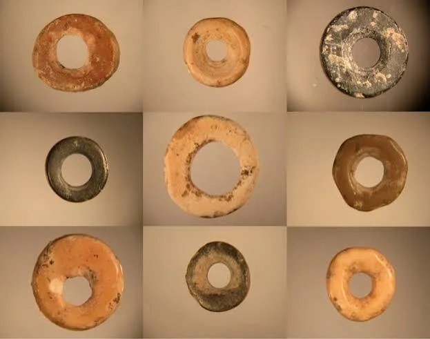
Beads are among the most widely distributed forms of personal ornament in the archaeological record. They can be made from stone, shell, bone, teeth, ceramic, glass, metal, and other materials. Their small size makes them portable, while their decorative and symbolic possibilities allow them to communicate identity, relationships, status, and cultural affiliation.

Because beads often travel far from the places where their raw materials were obtained, they can provide valuable evidence of exchange networks. A bead discovered at an archaeological site may reveal connections between communities separated by considerable distances.

However, the movement of a bead does not automatically prove direct trade between its place of manufacture and its final location. Objects can pass through many hands, be reused across generations, or acquire new meanings as they move between societies.

Why Beads Matter

Beads can serve several purposes.

They may be worn as necklaces, bracelets, clothing decorations, hair ornaments, or components of other objects. They can also be deposited in graves, used in ceremonies, or kept as treasured possessions.

Their significance varies by culture and context.

A bead made from an uncommon material might communicate access to distant resources. A particular shape or arrangement could identify membership in a social group, although such meanings must be established through evidence.

Researchers should not assume that all beads functioned primarily as status symbols. Some may have been ordinary ornaments, while others carried personal, protective, or ritual meanings.

Raw Materials and Geographic Origins

The first step in investigating bead exchange is identifying the material.

Shell beads may derive from marine or freshwater species. Stone beads can be made from minerals with distinct geological distributions. Bone and teeth can sometimes be linked to particular animal species.

Scientific methods can help establish the composition and possible origin of materials.

For example, mineralogical and elemental analysis may compare a stone bead with geological sources. Biological identification may help determine the species from which a shell or tooth originated.

However, identifying a material source does not automatically reveal the route it followed. A bead may have been transported as a finished object, manufactured elsewhere from imported raw material, or repeatedly exchanged between communities.

Manufacturing Techniques

Bead production involves several stages, including selecting the raw material, shaping it, perforating it, polishing it, and sometimes decorating it.

Manufacturing traces can reveal how these tasks were performed.

Researchers may identify drilling marks, grinding surfaces, unfinished blanks, broken pieces, and production debris. A concentration of such materials may indicate that beads were manufactured at the site.

If finished beads occur without production waste, they may have arrived through exchange, although portable craftspeople could also have made objects using equipment that left few traces.

Technological comparison can reveal similarities between bead-making traditions across different regions.

Exchange Networks and Distance

The geographic distribution of beads can help researchers investigate movement and exchange.

If a material originates far from the site where a bead was found, some form of transport must have occurred. This may involve trade, migration, gift exchange, marriage connections, pilgrimage, or other forms of social interaction.

The network need not have been centralized. An object could move through a sequence of small exchanges between neighboring communities.

Archaeologists use distribution maps, material sourcing, chronology, and manufacturing analysis to investigate these possibilities.

A wide distribution does not necessarily mean that a single large trading organization existed. Several overlapping networks may have moved similar objects.

Beads and Social Identity

Personal ornaments can help people express identity and relationships.

Differences in bead material, color, shape, or arrangement may correspond with age, gender, social role, community affiliation, or personal preference.

Burial contexts are particularly useful because researchers can examine how beads were arranged around the body and whether their distribution differed among individuals.

Yet social categories cannot be inferred from ornament alone. Burial customs vary, and the placement of an object may reflect ritual decisions made by surviving relatives rather than the deceased person's everyday clothing.

Interpretations should therefore be based on repeated patterns and comparison with other evidence.

Beads in Burials

Beads are frequently found in graves because personal ornaments may be buried with their owners or included as offerings.

Their arrangement can reveal whether they were worn as part of a necklace, attached to clothing, or placed separately.

Some graves contain large numbers of beads, while others contain very few or none. These differences may reflect social distinctions, personal choices, funerary customs, or preservation.

The absence of beads does not necessarily mean that a person lacked ornaments during life. Organic strings and other components may decay, leaving only part of the original object.

Beads and Gender Interpretation

Researchers sometimes investigate whether particular ornament types were associated with men, women, children, or other social categories.

Such patterns can be informative, but they must not be assumed in advance.

Modern ideas about gender do not automatically apply to prehistoric societies. The same bead type might have been used by several groups, and burial practices may not directly reflect everyday identity.

A careful study compares bead assemblages with skeletal evidence, burial context, settlement patterns, and broader cultural traditions.

Children, Learning, and Craft Production

Bead-making may have provided opportunities for learning specialized skills.

Unfinished objects, mistakes, broken blanks, and variation in manufacturing quality can help researchers investigate how techniques were taught and practiced.

However, imperfect objects do not automatically identify child workers. They may reflect different production stages, time pressure, or the work of adults with varying levels of expertise.

Experimental replication can help determine how difficult a particular manufacturing technique was and what kinds of waste it produced.

Exchange and Economic Value

Beads may have carried economic value, but their worth was not necessarily fixed.

An object made from a rare material could be prestigious in one region and relatively ordinary in another. Its value might depend on appearance, cultural significance, labor invested in production, or its association with a particular person.

Researchers should be cautious about describing beads as money unless evidence supports their use in standardized exchange.

An object can be valuable without functioning as currency.

Beadwork and Cultural Change

Changes in bead styles can help researchers investigate contact between communities.

A new material or manufacturing technique may appear alongside other evidence of exchange or migration. Similar styles across distant regions can suggest communication, imitation, or shared cultural traditions.

Yet stylistic similarity does not automatically prove direct contact. Similar designs can develop independently, and imported objects may be adopted in new ways.

Chronology is essential. Two communities cannot have exchanged a particular object directly if the relevant objects belong to widely separated periods.

Conservation and Scientific Analysis

Beads are often small and fragile. Organic materials may deteriorate, while minerals can crack or change appearance.

Cleaning and restoration can remove traces of manufacturing or residues that may be important for research.

Scientific analysis should therefore be planned carefully. Researchers may use microscopy, elemental analysis, and three-dimensional imaging to document objects without unnecessary damage.

The results should be interpreted alongside archaeological context rather than treated as independent proof of social relationships.

Conclusion

The archaeology of beadwork provides a powerful way to investigate prehistoric exchange, identity, craft production, and social relationships. Beads made from distant materials can reveal movement across landscapes, while manufacturing traces and burial arrangements help researchers understand how objects were produced, worn, and valued.

However, a bead's origin does not automatically identify its route, and its placement in a grave does not fully reveal its owner's identity. Reliable interpretations require material sourcing, technological analysis, spatial comparison, and careful contextual study.

Through these combined methods, beads become more than decorative objects. They preserve evidence of the connections people formed through trade, gift-giving, migration, personal relationships, and shared cultural traditions.

Detecting Ancient Tattooing Practices from Skeletal Markers

October 23, 2026

Introduction

Tattooing has a long history in human societies, but detecting ancient tattooing is difficult because pigment is usually applied to the skin rather than to bone. In favorable conditions, tattoos may survive in preserved skin, such as that of certain naturally or artificially preserved bodies. In most archaeological settings, however, the skin decomposes and leaves little direct evidence.

This creates an important distinction between the archaeology of tattooing and the study of skeletal remains. Bones may preserve evidence of cultural practices indirectly, but a skeletal feature should not be identified as a tattoo marker without strong supporting evidence.

Researchers investigating ancient tattooing may combine preserved soft tissue, pigment analysis, tattooing tools, historical descriptions, iconography, and burial context. Skeletal analysis can contribute to understanding the individual and the circumstances of preservation, but it cannot usually prove that a person was tattooed.

Why Tattooing Is Difficult to Detect

Tattooing involves introducing pigment into the skin. The process may leave little or no distinctive evidence in the skeleton.

Once soft tissue decomposes, the pigment may disappear or become dispersed, depending on the preservation conditions and the chemical properties of the material.

In exceptional circumstances, preserved skin can retain visible tattoo designs. These cases provide direct evidence, although interpreting the design's meaning remains a separate challenge.

When only skeletal remains survive, researchers generally need indirect evidence to investigate tattooing practices.

Skeletal Markers and Their Limitations

The phrase skeletal marker can refer to a feature of bone that provides information about an individual's life, health, activity, or physical history.

Examples include healed fractures, muscle attachment changes, dental modifications, and certain forms of bone remodeling.

None of these features is a generally accepted direct indicator of tattooing.

Tattooing usually affects the skin and superficial tissues, not the bone itself. Some tattooing practices may involve procedures that produce injury or scarring, but a skeletal change cannot be attributed to tattooing without a clear and specific connection.

Researchers must distinguish between evidence of bodily modification and evidence of a particular technique.

Direct Evidence from Preserved Bodies

The strongest evidence for ancient tattooing comes from preserved skin showing pigment arranged in deliberate patterns.

In some cold or otherwise favorable environments, human remains have retained skin and tattoos. Such discoveries can reveal the location, color, arrangement, and sometimes the technique used to create the designs.

Scientific imaging can help identify pigment beneath or within the skin. Microscopy and chemical analysis may reveal the materials used.

However, even direct evidence does not automatically explain the meaning of a tattoo. Its significance might have involved identity, healing, status, spirituality, protection, personal history, or several purposes at once.

Interpretation requires cultural and archaeological context.

Tools and Pigment Preparation

Tattooing tools may include sharp points, needles, or implements designed to puncture or abrade the skin. Pigments may be derived from carbon, minerals, or other materials.

Potential tattooing tools are difficult to identify because small pointed objects can serve many functions. Needles may have been used for sewing, leatherwork, ornament production, or medical procedures.

The identification becomes more convincing when tool morphology, microscopic wear, residue analysis, and archaeological context support tattooing.

Likewise, a black pigment found near a burial does not automatically indicate tattooing. It could have been used for painting, decoration, medicine, or other purposes.

Tattooing and Archaeological Context

Burial practices can provide clues about whether bodily decoration carried cultural significance.

Researchers may compare the treatment of bodies, associated objects, depictions of tattooed figures, and evidence from related communities.

Historical accounts can also describe tattooing customs, although such sources may be biased or may misunderstand the practices they record.

Iconographic evidence is especially useful when figures are depicted with recognizable patterns on the skin. Yet painted or carved body markings do not always represent tattoos; they might indicate clothing, body paint, scars, or artistic conventions.

Distinguishing Tattoos from Scars and Other Marks

Ancient bodily markings can result from several different processes.

Scarring may follow injury, surgery, ritual cutting, disease, or deliberate body modification. Body paint can produce visible patterns without permanently altering the skin. Tattooing introduces pigment into the skin and may remain visible long after healing.

These practices can overlap in cultural meaning while differing technically.

When skin is preserved, microscopic and chemical analysis may help distinguish pigment deposits from other changes. When only bones survive, the distinction may be impossible to establish.

Researchers should not label an unexplained skeletal feature as a tattoo-related marker simply because tattooing is known from the broader culture.

Chemical Analysis of Pigments

Pigment analysis can help identify the materials used in preserved tattoos.

Methods such as Raman spectroscopy, X-ray fluorescence, and microscopy may characterize certain mineral or carbon-based components.

The choice of method depends on the condition of the remains and the need to avoid damage.

Pigments can also be contaminated by burial soil, conservation treatments, or materials applied during earlier handling. Researchers must compare results with the surrounding environment and document sampling procedures.

A chemical identification may establish the presence of a pigment but not necessarily the technique by which it entered the skin.

Cultural Meaning and Social Identity

Tattooing can communicate information about identity, affiliation, personal experience, or social position.

Some societies have used tattoos in rites of passage, while others have associated them with protection, healing, status, or religious belief.

These meanings should not be treated as universal. The same pattern may carry different meanings across communities, and one individual may have had several reasons for receiving tattoos.

Archaeological interpretation should draw on reliable historical, ethnographic, and contextual evidence while recognizing that practices can change over time.

Ethical Considerations

Research involving human remains requires careful ethical consideration.

Researchers should follow applicable laws, consult descendant communities where relevant, and respect cultural expectations about the treatment and display of bodies.

High-resolution imaging and pigment sampling may provide valuable information, but these procedures should be justified and conducted with appropriate care.

Public communication should avoid treating tattooed individuals as curiosities or reducing their identities to their body markings.

Conclusion

Detecting ancient tattooing requires a clear distinction between direct evidence and indirect interpretation. Preserved skin containing deliberate pigment patterns can provide strong evidence, while tools, pigment residues, images, and historical accounts may support broader reconstructions of tattooing practices.

Skeletal markers alone generally cannot establish that an individual was tattooed. Bone can reveal aspects of a person's life, but tattooing primarily affects the skin.

A reliable study therefore combines careful preservation analysis, chemical investigation, contextual evidence, and cultural interpretation. This approach helps researchers investigate ancient body modification without assigning meanings or practices that the surviving evidence cannot demonstrate.

Submerged Battlefield Debris: Tidal Redistribution of Artifacts

October 23, 2026

Introduction

Battlefields located near rivers, estuaries, and coastlines can leave archaeological traces beneath the water. Weapons, armor fragments, ammunition, personal belongings, ship components, and other objects may be lost during combat or discarded afterward. Over time, tides, currents, storms, and sediment movement can shift these materials far from their original locations.

Submerged battlefield archaeology must therefore address two connected questions: what happened at the site, and how did the artifacts move after the event?

An object recovered underwater may not remain where it was originally deposited. Its current position could reflect tidal transport, erosion, dredging, later construction, or other disturbances. Reconstructing a battlefield requires an understanding of both historical events and the processes that shaped the underwater archaeological record.

What Is Submerged Battlefield Debris?

Battlefield debris includes objects associated with armed conflict. In a marine or estuarine setting, this may include weapons, ammunition, fragments of vessels, personal equipment, and materials related to military transport.

Some objects may have entered the water during combat. Others may have been discarded during retreat, dumped during later cleanup, or lost through ordinary maritime activity.

The presence of a weapon underwater does not automatically identify a battlefield. It may have come from a shipwreck, a training area, a later disposal event, or an unrelated accident.

A secure interpretation requires a combination of artifact analysis, historical research, spatial patterns, and environmental evidence.

How Tides Move Artifacts

Tides produce changing water levels and currents. Their strength and direction vary with coastal geography, water depth, weather, and the shape of the seabed.

Objects may be moved when currents are strong enough to overcome the forces holding them in place. Movement depends on an artifact's weight, shape, density, and interaction with sediment.

Small or lightweight objects may be transported more readily than large, heavy items. Yet even heavy objects can move during powerful storms, especially when the seabed is disturbed.

The movement is not always continuous. An artifact may shift during one storm, become buried, and remain stable for decades before being exposed again.

Sediment and Burial

Sediment plays a major role in the preservation of submerged artifacts.

Sand, silt, and mud can cover objects, protecting them from some forms of physical disturbance. Burial may also create conditions that slow corrosion for certain materials, although preservation depends on oxygen, chemistry, and other factors.

When currents remove sediment, previously buried artifacts may become exposed.

An exposed object can then be moved, damaged, or lost. Repeated cycles of burial and exposure may create a complex archaeological distribution.

Researchers must therefore distinguish between the original location of an object and the place where it was eventually recovered.

Identifying a Battlefield Through Artifact Patterns

The distribution of artifacts can help researchers identify areas associated with conflict.

A concentration of projectiles, weapons, military equipment, and personal belongings may suggest a battlefield or military activity zone.

The arrangement matters. Artifacts distributed along a narrow channel may have been transported by currents, while a more localized concentration could reflect an original deposit.

However, spatial patterns are rarely self-explanatory. A cluster may result from a shipwreck, a later dumping event, or a natural sediment trap.

Researchers use seabed mapping, artifact recording, sediment analysis, and historical accounts to evaluate competing explanations.

Historical Research

Historical records can provide information about battles, ship movements, military positions, and coastal geography.

Maps may identify former shorelines, channels, forts, landing places, or defensive barriers. Written accounts may describe the loss of vessels or equipment.

Yet historical descriptions are not always precise, and maps may simplify underwater terrain.

Researchers must compare historical evidence with archaeological findings rather than treating a written account as proof that a particular artifact belongs to the event.

Changes in coastlines and navigation channels can also mean that a modern map does not accurately represent the battlefield's original setting.

Dating Battlefield Debris

Dating artifacts can help establish whether they are consistent with a known conflict.

Weapon designs, manufacturing marks, inscriptions, and associated objects may provide chronological clues.

Scientific dating may be possible for suitable organic materials, although the material must be securely associated with the event.

A modern or later object found among older debris may reflect disturbance or continued use of the area.

Chronology should therefore be established for the assemblage as a whole, with particular attention to objects that may have been introduced after the original event.

Distinguishing Combat Losses from Later Disposal

Battlefields can be cleaned after combat. Weapons may be collected, damaged equipment salvaged, and bodies or debris removed.

As a result, the surviving archaeological assemblage may represent only a small portion of what was originally present.

Some objects might have entered the water during later salvage operations or disposal activities.

Archaeologists investigate these possibilities through the condition of artifacts, the distribution of remains, and documentary evidence about post-battle activities.

A battlefield's archaeological record is therefore not a complete inventory of the battle. It is the surviving product of combat, recovery, erosion, and later human activity.

Underwater Survey Techniques

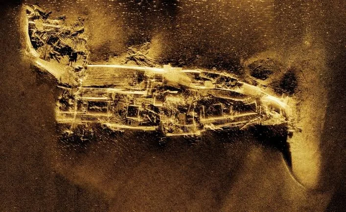
Submerged battlefield investigations may use side-scan sonar, multibeam bathymetry, magnetometry, remotely operated vehicles, and diver surveys.

Sonar can identify objects and changes in seabed topography. Magnetometry can detect some ferrous materials, while visual inspection provides detailed information about exposed remains.

Photogrammetry can produce three-dimensional records of objects and wreck sites.

Each method has limitations. Some materials are difficult to detect, sediment may conceal artifacts, and environmental conditions may restrict access.

A systematic survey is necessary to reduce the risk of recovering only the most visible or accessible objects.

Conservation of Underwater Artifacts

Objects recovered from underwater environments can deteriorate rapidly after exposure to air.

Metal artifacts may contain salts and corrosion products that become unstable during drying. Organic materials can also be damaged if their moisture conditions change suddenly.

Conservation specialists must assess the material and its condition before deciding how to recover, transport, store, or treat it.

In some cases, leaving an object in place and documenting it may be preferable to removal.

The conservation strategy should balance research value, long-term preservation, legal obligations, and the site's wider archaeological significance.

Ethical and Legal Considerations

Submerged battlefields may contain human remains, military graves, or culturally sensitive objects. Some sites may be protected under heritage or maritime laws.

Researchers should consult relevant authorities and follow established procedures before conducting intrusive work.

Artifacts should not be removed simply because they are accessible. Their location and association with other objects may provide more information than the object alone.

Responsible battlefield archaeology prioritizes documentation, preservation, and the respectful treatment of human remains.

Conclusion

Submerged battlefield debris can reveal important information about conflict, military equipment, and maritime history. Yet tides, currents, sediment movement, storms, and later human activity can redistribute artifacts, making their original locations difficult to reconstruct.

A weapon recovered underwater does not automatically prove the presence of a battlefield. Reliable interpretation depends on artifact analysis, spatial mapping, historical research, dating, and an understanding of local hydrodynamics.

By studying how objects entered the water and how they moved afterward, archaeologists can reconstruct not only the events of conflict but also the environmental processes that shaped the surviving evidence. The seabed becomes a historical landscape whose contents must be interpreted through both human history and natural change.

The Biosignatures of Ancient Urban Wastewater Management

October 23, 2026

Introduction

Urban wastewater management is often associated with modern infrastructure, but past societies also developed ways to collect, redirect, and dispose of liquid waste. Drains, channels, cesspits, wells, and other structures formed part of the environmental systems that supported growing settlements.

These systems can leave biological and chemical traces in the archaeological record. Microscopic organisms, parasite eggs, pollen, plant remains, fecal biomarkers, and changes in sediment chemistry may reveal how wastewater moved through ancient towns.

The study of these traces can help researchers reconstruct sanitation practices, environmental conditions, and aspects of urban public health. However, biological evidence must be interpreted carefully because wastewater deposits may receive material from several sources, and the same biosignature can occur in different contexts.

What Are Biosignatures?

A biosignature is evidence associated with biological activity. In archaeological wastewater studies, the term may refer to microscopic remains, chemical compounds, or biological structures preserved in sediment and other materials.

Examples include parasite eggs, pollen, plant fragments, fecal biomarkers, and certain microbial residues.

These indicators can reveal the presence of organic waste or help identify the types of materials entering a drainage system.

Yet a biosignature does not automatically identify a specific disease, individual, or sanitation practice. Its meaning depends on preservation, depositional context, and comparison with other evidence.

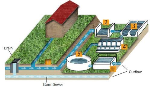
Ancient Urban Wastewater Systems

Historical towns used a variety of systems to manage wastewater.

Some had covered drains and channels that carried water away from streets or buildings. Others relied on open ditches, cesspits, wells, or combinations of different arrangements.

The purpose of a feature may have changed over time. A drain could carry rainwater, household wastewater, industrial waste, or mixtures of these materials.

Archaeologists examine construction, slope, sediment deposits, and connections with buildings to determine how a system likely functioned.

A channel that appears to be a sewer may instead have been designed primarily for stormwater or irrigation.

Fecal Biomarkers

Certain organic compounds can be associated with human or animal fecal material.

Researchers may investigate sterols and related compounds in sediment to determine whether organic waste entered a deposit.

The relative abundance of particular compounds can sometimes help distinguish possible sources, but interpretation is complex. Compounds may degrade, migrate, or be introduced through other forms of contamination.

A chemical signal consistent with fecal waste does not automatically identify a specific household or establish that the entire drainage system carried sewage.

The strongest conclusions combine biomarker analysis with the structure's physical characteristics and other archaeological evidence.

Parasites and Public Health

Parasite eggs can survive in some wastewater-related deposits.

Their identification may provide evidence of infections affecting people or animals who contributed waste to the system.

Different parasites have different life cycles and transmission routes. Some are associated with contaminated soil or water, while others are linked to food or particular environmental conditions.

The presence of parasite eggs does not directly establish disease prevalence across the whole population. A deposit may represent a limited number of users or a short period of accumulation.

Researchers must also consider whether the eggs entered the deposit during the system's original use or through later disturbance.

Microbial Evidence

Some archaeological deposits preserve biological material that can provide information about past environmental conditions.

However, ancient DNA and microbial studies face substantial challenges. DNA can degrade, and modern contamination may introduce misleading signals.

Researchers use controlled sampling, laboratory protocols, and comparison with surrounding sediment to assess whether detected material is likely to be ancient.

Even when microbial evidence is recovered, identifying a microorganism does not always reveal whether it caused disease. Many microbes are part of ordinary environmental or human-associated communities.

Interpretation requires careful consideration of the organism, the context, and the limitations of the analytical method.

Wastewater and Environmental Chemistry

Wastewater can alter the chemistry of surrounding soils and sediments.

Organic matter, nutrients, metals, and other compounds may accumulate in drainage channels or nearby deposits.

These patterns can reveal where waste was concentrated and how the system functioned.

Yet chemical signatures can have several origins. Elevated nutrients may result from animal pens, agricultural runoff, household waste, or other activities.

Researchers compare wastewater deposits with samples from surrounding areas and investigate the relationship between chemistry and the structure's layout.

Mapping Wastewater Flow

The physical design of a drainage system can help reconstruct the direction of flow.

Researchers examine channel slopes, inlets, outlets, sediment deposits, and connections with buildings or public spaces.

Sediment may accumulate in slower-flowing sections, while stronger currents can remove material from other areas.

The present condition of a channel may differ from its original form because of repairs, blockages, erosion, or later construction.

Reconstructing wastewater movement therefore requires architectural analysis alongside sediment studies.

Wastewater and Urban Inequality

Sanitation infrastructure may reflect differences in wealth, political authority, and access to public services.

Some neighborhoods may have had more effective drainage than others. Wealthier residences might have possessed private facilities, while densely populated districts relied on shared systems.

Archaeologists can compare the design and maintenance of drainage features across a settlement.

However, infrastructure alone does not establish actual sanitation quality. A well-built drain may have been poorly maintained, while a simple system may have worked effectively under particular environmental conditions.

Historical documents and environmental evidence can help clarify how the systems were used.

Disease, Density, and Urban Life

Growing towns can face sanitation challenges when waste accumulates near homes, markets, wells, and waterways.

Wastewater systems may reduce certain risks by directing waste away from living areas, but they can also transport contaminants if they discharge into water sources used by residents.

The relationship between sanitation and disease depends on many factors, including water supply, food preparation, housing, population density, and local ecology.

Archaeological biosignatures can contribute to this investigation, but they cannot independently reconstruct the complete public health situation of a town.

Industrial and Domestic Waste

Not all wastewater came from toilets or households.

Workshops could release water containing dyes, minerals, fats, or other substances. Food processing, animal slaughter, textile production, and craft activities might also contribute waste to urban channels.

The chemistry of a drain may therefore reflect several industries and domestic practices.

Researchers must consider the wider settlement economy when interpreting deposits.

A metal-rich residue in a drainage channel, for example, may relate to nearby craft production rather than ordinary household wastewater.

Preservation and Sampling

Biological and chemical evidence survives unevenly.

Waterlogged, oxygen-poor deposits may preserve some materials well, while exposed or frequently disturbed sediments may lose important traces.

Sampling strategies should account for the structure's different layers and locations. A single sample may not represent the entire drainage system.

Controls from nearby soils can help distinguish signals associated with wastewater from natural background conditions.

The methods and limitations should be documented so that results can be compared with other sites.

Conclusion

The biosignatures of ancient urban wastewater management can reveal how communities handled waste and how sanitation systems interacted with the surrounding environment. Fecal biomarkers, parasite eggs, microscopic remains, and sediment chemistry can provide evidence of waste disposal, biological activity, and potential public health challenges.

However, these indicators are not self-interpreting. A chemical signature may have several sources, and parasite remains do not automatically reveal the prevalence of disease.

By combining biological analysis with drainage architecture, sedimentology, urban archaeology, and historical evidence, researchers can reconstruct how wastewater moved through ancient settlements. These studies show that sanitation was not a minor technical concern; it was part of the infrastructure that shaped urban life, environmental health, and the everyday experiences of residents.

The Small-Scale Fortifications: Hillock Defenses and Local Feuds in Pre-Modern Europe

October 23, 2026

Introduction

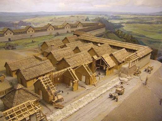
Fortifications are often associated with large castles, royal armies, and major wars. Yet pre-modern Europe also contained smaller defensive structures built on hills, rocky outcrops, ridges, and other locally advantageous positions.

These modest fortifications may have protected settlements, controlled routes, guarded livestock, sheltered residents during raids, or served as centers of local authority. Some were constructed during periods of political instability, while others may have been used intermittently over long periods.

The relationship between small fortifications and local feuds is particularly interesting. Local disputes could involve land, inheritance, trade, political allegiance, or access to resources. However, the existence of a defensive structure does not prove that a feud occurred at that location. Archaeologists must establish the structure's chronology, function, and relationship to the surrounding settlement.

What Counts as a Small-Scale Fortification?

Small-scale fortifications vary widely in design and size.

They may include earth banks, ditches, stone walls, timber palisades, small towers, defended enclosures, and compact hilltop strongholds.

Some structures were permanent, while others were built quickly or reused existing landscape features.

A hillock could offer a defensive advantage because it provides visibility and makes direct access more difficult. Even a relatively small structure might allow a limited group to monitor movement along a road, valley, river crossing, or agricultural area.

However, not every enclosed hilltop was a fortification. Some sites served as settlements, religious locations, animal enclosures, or places of refuge without being designed primarily for combat.

Why Build on a Hillock?

Elevated positions can improve visibility and provide natural protection.

A small rise may allow defenders to observe approaching people or animals. Steep slopes can restrict access, while nearby valleys or passes may provide strategic control over movement.

The practical value of a hillock depends on its surroundings. A low rise overlooking an important route may be more useful than a taller hill located far from settlement or communication networks.

Researchers must reconstruct the landscape as it existed when the structure was used. Modern roads, vegetation, and construction may have changed the visibility and accessibility of the site.

Construction Methods

Small fortifications could be built using locally available materials.

Earthworks might consist of a bank and ditch. Timber defenses could leave postholes or traces of palisades. Stone walls might use dry-stone construction or mortar, depending on local traditions and the period.

The choice of construction materials affected how quickly a fortification could be built and how long it could survive.

Some structures may have been repaired repeatedly, creating several construction phases. Others were temporary and left only subtle archaeological traces.

Architectural analysis and excavation can help distinguish the original structure from later alterations.

Local Feuds and Political Fragmentation

In some pre-modern settings, local conflict arose from disputes over land, inheritance, taxation, jurisdiction, trade, or political allegiance.

Small fortifications could provide protection for a household, village, estate, or local authority. They might also serve as visible statements of control over a territory.

Yet a defensive structure could have several purposes. It might protect residents from raiders, provide a refuge during wider conflict, or monitor movement along a route without being directly connected to a specific feud.

To link a fortification with local conflict, researchers need evidence such as destruction layers, weapons, historical documents, or a broader pattern of conflict-related sites.

Archaeological Evidence of Defense

Several features can support a defensive interpretation.

A ditch or bank may restrict movement. A wall may be positioned to protect the most accessible side of a hill. Gates or narrow entrances may control access, while elevated platforms may provide observation points.

The location of these features matters. A wall that blocks a practical approach to a site may have had a defensive purpose, although it could also function as a boundary.

Researchers compare the construction with known examples and examine whether the layout makes sense for defense.

No single feature proves that fighting took place there.

Weapons and Destruction Layers

Weapons and ammunition may be found at fortified sites, but their interpretation requires caution.

A projectile point, blade, or other weapon could have been lost, stored, traded, or deposited during a later period. Its presence does not necessarily indicate a battle.

Destruction layers can provide stronger evidence when they include burning, collapsed structures, damaged objects, and a clear chronological relationship to the fortification.

Even then, fire may result from accidental events rather than conflict.

Archaeologists investigate the pattern of damage, the condition of artifacts, and historical context before attributing destruction to an attack.

Controlling Roads and Resources

Small fortifications may have been positioned near routes, bridges, river crossings, grazing lands, or agricultural resources.

Such locations could allow a group to monitor movement and protect valuable assets.

A fortification overlooking a narrow pass might have helped control access, while a structure near farmland could have provided refuge during raids.

However, strategic location alone does not prove that a site controlled trade or collected tolls. Researchers need additional evidence, such as associated settlements, storage features, historical records, or patterns of movement.

Settlement Relationships

A fortification should be studied in relation to nearby habitation.

Archaeologists may investigate whether houses, workshops, storage areas, or animal enclosures were located within or around the defended area.

A compact hilltop structure might have protected a small settlement, while another could have served as a refuge for residents living in the surrounding countryside.

The distinction is important because a fortification used only during emergencies may leave a different archaeological signature from one occupied continuously.

Artifact distributions and occupation layers can help distinguish these possibilities.

Dating and Reuse

Small defensive sites may have long and complicated histories.

A structure built during one period might be reused during later conflict or incorporated into a new settlement. Its present form may therefore combine several phases of activity.

Dating may rely on pottery, coins, building techniques, radiocarbon samples, or other evidence associated with construction and occupation.

The date of an artifact found on the site does not automatically establish the construction date of the fortification. The object may have been deposited long after the original structure was built.

Careful stratigraphic analysis is essential for reconstructing the site's chronology.

Comparing Archaeology with Historical Records

Written documents can identify local conflicts, land disputes, or defensive responsibilities.

Court records, estate documents, chronicles, and administrative accounts may describe raids, fortification work, or disputes between neighboring authorities.

However, the historical record is often uneven. Some communities generated extensive documentation, while others left little written evidence.

A lack of written references does not prove that a fortification was unrelated to conflict. Conversely, a nearby record of a feud does not automatically connect the event with a particular structure.

Archaeology and documentary history should be used together while keeping their uncertainties visible.

The Limits of the Feud Interpretation

The term local feud can suggest a personal or family conflict, but the causes of pre-modern violence were diverse.

A small fortification might have been used during a wider war, a raid, a period of insecurity, or a dispute over territory. Its construction may have been precautionary rather than a response to a specific attack.

Researchers should therefore avoid presenting every small defensive structure as evidence of violent rivalry.

The strongest interpretation is the one that explains the archaeological evidence while considering alternative purposes and the broader historical setting.

Conservation of Small Fortifications

Small earthworks and hilltop defenses can be vulnerable to agriculture, road construction, erosion, vegetation growth, and unauthorized excavation.

Their low profiles make them difficult to recognize, especially where modern land use has altered the terrain.

Survey, mapping, remote sensing, and limited excavation can document their condition and preserve information about their layout.

Conservation efforts should also consider the site's relationship with the surrounding landscape. A fortification's strategic value may only be understandable when its views, routes, and neighboring settlements are considered.

Conclusion

Small-scale fortifications provide valuable evidence for local defense, territorial control, and political relationships in pre-modern Europe. Hillock defenses, earthworks, walls, ditches, and compact enclosures can reveal how communities responded to insecurity and made use of the landscape.

However, a defensive structure does not automatically prove that a local feud occurred. Its purpose may have included refuge, surveillance, protection of resources, or participation in wider military activity.

Reliable interpretations depend on dating, architectural analysis, associated artifacts, settlement patterns, and historical records. By examining these structures within their regional context, archaeologists can better understand how local communities organized defense and responded to the changing pressures of pre-modern life.

Submerged Bronze Age Causeways of the North Atlantic Isles

October 23, 2026

Introduction

The North Atlantic islands contain a rich archaeological record of prehistoric movement, settlement, and interaction. During the Bronze Age, communities across parts of northwestern Europe developed varied relationships with the sea, using boats to travel between islands, exploit marine resources, and maintain connections with neighboring populations.

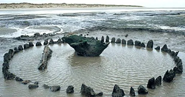
The possibility of submerged causeways introduces an important question: how did ancient people connect areas of land that are now separated by water or altered coastlines? A causeway is a constructed route across wet ground, tidal flats, shallow water, or another difficult landscape. Some causeways may survive underwater because sea levels rose, land subsided, or coastal processes changed the environment.

However, a submerged stone alignment or raised feature does not automatically represent a Bronze Age causeway. Natural geology, later construction, and changes in sediment movement can create similar patterns. Establishing the age and function of a suspected causeway requires careful underwater survey, geological analysis, and archaeological dating.

The North Atlantic as a Connected Landscape

The North Atlantic was not necessarily a barrier to prehistoric communities. Islands, coastal promontories, sheltered bays, and maritime routes could connect people who lived across substantial distances.

Communities used boats and other forms of water transport long before the Bronze Age, although the specific vessels and sailing practices varied across time and region.

The sea also shaped settlement patterns. Access to fish, shellfish, marine mammals, seabirds, and coastal plants could support communities whose economies combined land-based and marine resources.

Understanding submerged causeways requires this wider context. A constructed route may have connected two areas of a single island, linked a settlement with a tidal resource zone, or provided access across wet ground near a harbor.

What Is a Causeway?

A causeway is a raised or constructed route designed to make movement easier across terrain that would otherwise be difficult to cross.

It may consist of stone, earth, timber, or combinations of materials. Some causeways cross wetlands, while others extend through tidal areas or shallow water.

The design depends on local conditions. A route across a marsh may require a different structure from one built across a rocky intertidal zone.

Causeways may also have served several functions. A raised route could facilitate everyday movement, connect settlements, provide access to ritual places, or support the movement of livestock and goods.

Archaeologists must establish the relationship between a structure and its landscape before assigning a particular function.

Why Causeways Become Submerged

Several processes can place a former causeway underwater.

Relative sea-level rise can inundate low-lying land. Local tectonic movement can alter the elevation of the coast, while erosion may remove the sediment that once supported a route.

In some regions, postglacial land movement has produced complex changes in relative sea level. Land can rise after the removal of massive ice sheets, while other areas may experience different combinations of uplift and sea-level rise.

Coastal sedimentation can also alter how a causeway appears. A route may become buried beneath sand or mud before later erosion exposes it.

The local geological history is therefore essential for determining why a suspected causeway is submerged.

Identifying Submerged Structures

Underwater archaeological surveys can use sonar, bathymetric mapping, photogrammetry, and direct inspection.

These techniques may reveal linear stone arrangements, raised seabed features, or repeated structural patterns.

Researchers examine whether the feature follows a practical route between two landforms and whether its construction differs from the surrounding geology.

A naturally occurring rock ridge may resemble a built causeway. Similarly, glacial deposits or later stonework can produce artificial-looking alignments.

The strongest interpretations rely on evidence of construction, such as arranged stones, repeated structural dimensions, or a clear relationship with associated archaeological features.

Dating a Possible Bronze Age Causeway

Establishing a Bronze Age date requires more than observing that a feature lies underwater.

Potential evidence may include securely associated artifacts, datable organic material, construction deposits, or environmental layers that establish when the route was built or used.

Radiocarbon dating may be possible when suitable organic material survives in a secure context. Other dating techniques may help establish the age of surrounding sediments.

The dating of the structure itself must be distinguished from the date when it became submerged. A route may have been used for centuries before changes in sea level or erosion altered its setting.

If no direct dating evidence exists, the feature should be described as a possible prehistoric structure rather than a confirmed Bronze Age causeway.

Everyday Movement and Economic Activity

If a causeway was used during the Bronze Age, it could have supported practical activities such as moving between settlement areas, accessing fishing grounds, collecting shellfish, or transporting materials.

A raised route across a tidal area might have allowed people to reach resources that were otherwise difficult to access at particular stages of the tide.

A causeway might also have reduced the need for short boat journeys or created a more predictable path across wet terrain.

However, the function of a route cannot be determined from its shape alone. Researchers need to examine nearby settlements, resource zones, artifacts, and the environmental conditions that existed during its use.

Causeways and Social Organization

Constructing a substantial causeway can require labor, materials, and planning.

A large structure might suggest cooperation among several households or a community with the capacity to organize shared work.

Yet construction scale does not directly reveal political hierarchy. A route may have been built gradually through repeated maintenance, or a relatively small group may have created it for a specific purpose.

Evidence from settlements, food production, burial practices, and other construction projects can help researchers investigate how labor was organized.

Environmental Reconstruction

Reconstructing the landscape at the time of construction is crucial.

Researchers may study sediment cores, pollen, plant remains, shoreline deposits, and sea-level indicators to establish whether the area was dry land, marsh, tidal flat, or shallow water.

A route that is submerged today may have been entirely terrestrial when it was built. Alternatively, it may have been designed from the beginning to cross a wet or tidal area.

The distinction affects how the structure should be interpreted.

Environmental reconstruction can also reveal whether the route became unusable gradually or was affected by a more sudden event.

Conservation Challenges

Submerged archaeological structures can be difficult to preserve.

Wave action, currents, sediment movement, marine organisms, fishing equipment, anchoring, and coastal development can damage or obscure the remains.

A structure may survive well while buried but deteriorate rapidly after exposure.

Conservation strategies may include detailed mapping, monitoring, protective measures, and restricting damaging activities where appropriate.

Excavation is not always necessary. In some cases, documentation and continued preservation in place provide the best option.

Conclusion

Submerged Bronze Age causeways of the North Atlantic Isles offer a valuable framework for investigating prehistoric movement and changing coastal landscapes. If confirmed, such structures could reveal how communities organized access to resources, connected settlement areas, and adapted to wetlands or tidal environments.

Yet submergence alone does not establish either age or function. Researchers must distinguish built routes from natural formations and separate the date of construction from the date of inundation.

By combining underwater archaeology, geological analysis, environmental reconstruction, and careful dating, researchers can investigate whether these structures represent prehistoric engineering and how coastal change transformed the landscapes in which people lived.

Early Pastoral Corridors in the Sahel: Archaeology of Herd Routes

October 23, 2026

Introduction

The Sahel is a broad transitional region south of the Sahara, extending across parts of West and Central Africa. Its landscapes include grasslands, shrublands, seasonal wetlands, river corridors, and areas where rainfall varies greatly from year to year.

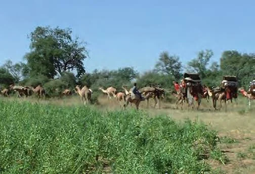
For pastoral communities, movement between water sources and grazing areas has long been an important way to manage livestock. Routes used by herders may connect dry-season water, seasonal pasture, settlements, markets, and places of cultural significance.

The archaeology of early pastoral corridors investigates how these routes developed and how they changed through time. Because livestock movement often leaves subtle or dispersed evidence, researchers must combine settlement archaeology, animal remains, environmental records, remote sensing, and historical or oral traditions where appropriate.

The goal is not simply to draw ancient routes on a map. It is to reconstruct the relationships among mobility, climate, livestock management, and social organization.

Pastoralism in the Sahel

Pastoralism involves raising and managing livestock, often through movement between different grazing areas.

The animals kept vary across the region and may include cattle, sheep, goats, and camels, depending on local ecological conditions and historical periods.

Some communities practice extensive mobility, while others combine herding with farming, trade, or settled activities. Herd movements may be organized at the household, lineage, community, or wider regional level.

The Sahel should not be treated as a uniform pastoral landscape. Rainfall, vegetation, water availability, and political boundaries differ significantly from place to place.

Why Corridors Matter

A pastoral corridor is a route or connected series of routes used to move livestock between resources.

The route may follow a river, cross a plain, pass through a gap in a ridge, or connect seasonal grazing zones.

Some corridors are shaped primarily by ecology. Others may reflect established rights of access, agreements between communities, or the need to avoid cultivated land and conflict zones.

Routes can also change over time as water sources disappear, vegetation shifts, settlements expand, or political conditions change.

A corridor is therefore not always a single fixed line. It may be a flexible network of alternative paths.

Archaeological Evidence of Herd Movement

Pastoral routes can leave several types of evidence.

Archaeologists may investigate animal enclosures, settlement remains, wells, watering places, tracks, dung deposits, and concentrations of artifacts associated with repeated visits.

Animal bones can reveal which species were present and how they were managed. Age profiles may indicate whether animals were kept for meat, milk, breeding, or other purposes.

However, a settlement containing livestock bones does not automatically identify a long-distance pastoral corridor. The evidence must be connected with other sites and with the environmental conditions that made movement practical.

Water Sources and Seasonal Mobility

Water is one of the most important factors shaping pastoral movement in the Sahel.

Seasonal rainfall can create temporary pools, fill wetlands, and support the growth of grasses. During dry periods, herders may depend more heavily on permanent rivers, wells, springs, or managed water points.

Archaeological research can investigate how access to water influenced settlement and movement.

Ancient wells, reservoirs, and other water-management features may provide evidence of repeated use. Yet their dates and functions must be established carefully, because structures can be repaired or reused over long periods.

Environmental records can help reconstruct whether particular water sources were available during the period under investigation.

Climate and Pastoral Corridors

The Sahel has experienced substantial climatic variation over the course of human history.

Changes in rainfall can influence the distribution of vegetation, the reliability of water sources, and the location of suitable grazing land.

Researchers study these changes through lake sediments, pollen, plant remains, archaeological settlement patterns, and other environmental indicators.

However, climate does not determine human behavior in a simple way. Communities may respond to similar conditions differently depending on livestock species, technology, social relationships, and access to trade.

A shift in settlement locations may reflect environmental change, political conflict, economic opportunity, or several factors acting together.

Mobility and Archaeological Visibility

Mobile communities can be difficult to study because their camps may leave fewer durable structures than permanent settlements.

Temporary shelters, portable equipment, and repeated movement may produce a dispersed archaeological record.

This does not mean pastoral communities lacked stable social systems or detailed knowledge of the landscape. Mobility can be organized through established seasonal routines and long-standing relationships between groups.

Researchers may identify repeated occupation through artifact scatters, animal remains, hearths, soil chemistry, and the relationship between camps and water sources.

Corridors and Exchange Networks

Pastoral routes can also connect communities through trade and social interaction.

Herders may exchange livestock products, hides, milk, meat, and other goods for grain, tools, textiles, or manufactured objects.

A corridor may therefore serve as more than a path for animals. It can be part of a wider network linking markets, settlements, and political centers.

Archaeologists investigate these connections through the distribution of materials, settlement patterns, and evidence of production and exchange.

However, an object found far from its source does not necessarily prove that pastoralists transported it. Other traders or intermediary communities may have been involved.

Conflict, Cooperation, and Access Rights

Access to pasture and water can require negotiation between different groups.

Communities may establish customary routes, seasonal agreements, or rules about when livestock can enter particular areas. These arrangements can change over time as populations, environmental conditions, and political institutions change.

Archaeology rarely preserves the rules themselves directly. Instead, researchers may investigate settlement boundaries, defensive structures, resource locations, and patterns of movement.

Historical records and oral traditions can provide additional context, although each source must be evaluated within its own historical setting.

Pastoral mobility should not automatically be interpreted as a source of conflict. Cooperation, exchange, and negotiated access are also important parts of the history of herding.

Remote Sensing and Landscape Mapping

Satellite imagery and digital mapping can help identify possible routes, abandoned water features, settlement remains, and changes in vegetation.

Remote sensing is especially valuable in large or difficult-to-access regions.

However, visible tracks may be modern, and old paths may follow the same corridors used by contemporary herders. Identifying an ancient route requires chronological evidence.

Ground survey, artifact recording, and environmental analysis remain essential for distinguishing historical features from recent activity.

Pastoral Corridors and Modern Change

Modern roads, fences, cultivation, mining, urban growth, and changing land policies can alter traditional movement routes.

These changes may affect access to water and pasture and can transform the archaeological landscape.

Studying earlier corridors can help researchers understand the long history of mobility, but archaeological findings should not be used to claim that one historical route must remain unchanged today.

Pastoral communities adapt their movements in response to changing conditions, and modern decisions require consideration of current rights, needs, and environmental circumstances.

Conclusion

The archaeology of early pastoral corridors in the Sahel can reveal how herders moved livestock through changing environments and maintained connections between water sources, grazing zones, settlements, and markets.

The evidence may include wells, animal enclosures, camp remains, artifact scatters, and environmental records. Yet no single feature proves that a long-distance herd route existed.

Reliable reconstruction requires mapping multiple sites, establishing their chronology, and understanding the ecological and social conditions that influenced movement. By studying these relationships, archaeologists can investigate pastoralism as a flexible and organized way of life rather than simply a pattern of wandering across the landscape.

The Tiny Temples of Highland Papua: Ritual Stones and Caves

October 23, 2026

Introduction

The highlands of Papua contain diverse landscapes and cultural traditions, including steep mountains, valleys, caves, rock shelters, and settlement areas shaped by long histories of human occupation. Across parts of the wider Papuan region, ritual life has been connected with places in the landscape, ancestral traditions, and culturally significant objects.

Small shrines, stone arrangements, and caves can be important subjects for archaeology because they may preserve evidence of ritual activity without the monumental architecture associated with large temples in other regions.

However, the expression "tiny temples" should be treated as a descriptive framing rather than a universal architectural category. A small stone arrangement or cave may have served ritual, domestic, funerary, defensive, or other purposes. Its function cannot be determined from size or appearance alone.

Research must be grounded in the specific region, archaeological period, and community tradition involved.

Highland Landscapes and Human Settlement

Highland environments are characterized by varied elevations, steep slopes, valleys, and changing local climates.

These features influence where people settle, how they travel, and which resources are available. Some valleys support agriculture, while surrounding slopes and forests provide other resources.

Caves and rock shelters may offer protection from weather or convenient places for temporary activity. Their significance can change over time, and a location used for domestic purposes during one period might acquire a different role later.

Understanding ritual sites therefore begins with reconstructing the broader landscape and its history of occupation.

What Makes a Place Sacred?

A sacred place is not necessarily defined by monumental construction.

Its significance may derive from ancestral associations, origin narratives, ritual practices, relationships with spiritual beings, or community histories.

A place may be recognized through restrictions on access, the treatment of particular objects, repeated ceremonies, or traditions that connect it with important events.

Such meanings are not always visible in the material record.

Archaeologists should work with relevant cultural custodians and local researchers when investigating places that retain religious or social significance. Some knowledge may be restricted, and communities should help determine what can appropriately be recorded or published.

Ritual Stones and Arrangements

Stones can be used in many ways within ritual and social life.

They may form small arrangements, mark boundaries, support offerings, or serve as components of a larger structure. In other contexts, stones may be associated with practical activities such as building, food preparation, or tool production.

A stone arrangement becomes a convincing candidate for ritual activity when its context supports that interpretation.

Researchers examine the arrangement's form, location, associated artifacts, use history, and relationship to other features.

A distinctive arrangement is not automatically a shrine. Natural geological patterns and ordinary construction practices must also be considered.

Caves as Cultural Places

Caves can provide sheltered environments and distinctive sensory settings.

Their darkness, acoustics, temperature, and physical separation from everyday settlement areas may influence how people use them. Some caves can also contain water, mineral resources, or archaeological deposits protected from certain forms of weathering.

Potential evidence of ritual activity might include deliberately placed objects, repeated deposits, markings, or architectural modifications.

However, caves are often used for multiple purposes. A cave containing pottery or animal bones may represent habitation, storage, ritual activity, or several different phases of use.

Careful stratigraphic analysis is necessary to establish the sequence of activities.

Archaeological Evidence and Interpretation

Researchers may investigate stone features, pottery, charcoal, bone, pigments, and other materials to understand how a cave or small structure was used.

Radiocarbon dating can sometimes establish the age of suitable organic remains. Microscopic analysis may identify residues, while spatial mapping can reveal where objects were placed.

Yet an artifact's presence does not automatically identify the activity that produced it.

For example, charcoal might derive from cooking, heating, or a ritual fire. A decorated object may have been used in daily life before being deposited in a special location.

Interpretations should account for the full archaeological sequence and avoid assigning a ritual meaning to every unusual object.

Oral Traditions and Cultural Custodianship

Oral histories may explain why a cave or stone feature matters to a community.

Such traditions can provide information about place names, ancestral connections, customary responsibilities, and restrictions on access.

They should not be treated simply as stories that archaeology must prove or disprove. Oral traditions can preserve cultural knowledge and historical perspectives that are not available through excavation.

At the same time, researchers should recognize that traditions may change and that different community members may hold different interpretations.

Consultation should be conducted respectfully, with attention to local protocols and decisions about the public sharing of information.

Ritual Sites and Everyday Life

A small ritual place may be closely connected with domestic life rather than separate from it.

A household or community may maintain a sacred location near a settlement, use a cave during particular events, or place ritual objects within an area that also serves practical purposes.

This makes it important to avoid dividing archaeological sites too rigidly into religious and secular categories.

The same place may support several activities, and its meaning may change according to the occasion.

Researchers should investigate how ritual practice interacted with food production, kinship, settlement, and the use of natural resources.

Preservation Challenges

Highland caves and stone structures can be affected by erosion, water infiltration, landslides, vegetation, and modern construction.

Archaeological deposits may also be disturbed by animal activity or repeated human use.

Because small features can be difficult to recognize, detailed mapping and careful recording are especially important.

Conservation should consider both physical remains and living cultural relationships. A site may be important even if it contains few artifacts or lacks monumental architecture.

Avoiding Overgeneralization

Papua is culturally and geographically diverse, and traditions vary across communities and historical periods.

It would be misleading to treat all highland caves or stone arrangements as parts of one shared religious system. Nor should modern cultural practices automatically be projected into the distant past without supporting evidence.

Each site requires its own chronological and cultural framework.

Comparisons with other parts of the Pacific or Southeast Asia may be useful, but similarities do not prove that the sites shared identical functions or histories.

Conclusion

Small ritual places in the highlands of Papua can provide important evidence of how communities connected cultural traditions with caves, stones, and the wider landscape. Their significance may be expressed through repeated practices, object placement, oral histories, and relationships maintained by local custodians.

Yet small structures and caves cannot automatically be classified as temples. Archaeological context, chronology, and community knowledge are essential for understanding their function.

By combining careful fieldwork with respectful collaboration, researchers can investigate the diversity of ritual landscapes without forcing them into architectural categories developed elsewhere. Such work can broaden the understanding of sacred space by recognizing that meaningful places do not need to be monumental to hold lasting cultural importance.

Riverbank Salt Crystallization: Effects on Buried Organic Artefacts

October 23, 2026

Introduction

Buried organic artifacts are often among the most fragile remains recovered from archaeological sites. Wood, leather, plant fibers, textiles, seeds, and other organic materials can survive under favorable conditions but deteriorate rapidly when those conditions change.

Riverbank environments can create complex preservation settings because water levels, sediment movement, groundwater chemistry, and seasonal flooding may vary considerably. In areas where dissolved salts accumulate, salt crystallization can contribute to the deterioration of nearby materials and the surrounding archaeological deposits.

The effects depend on the type of salt, the nature of the organic material, moisture conditions, and the physical structure of the sediment. Understanding these interactions is important for both archaeological interpretation and conservation.

Why Organic Artifacts Survive

Organic materials usually decompose through biological and chemical processes.

Wood and plant fibers may be attacked by microorganisms, while leather and other animal-derived materials can deteriorate under conditions that favor decomposition. Oxygen availability, moisture, temperature, acidity, and burial chemistry all influence preservation.

Some waterlogged environments preserve organic materials because limited oxygen slows the activity of many decomposing organisms. Other deposits preserve materials because they remain dry or because their chemistry inhibits certain forms of decay.

Preservation is therefore not determined by water alone. The balance between moisture, oxygen, chemistry, and biological activity is crucial.

How Salts Accumulate Along Riverbanks

Salts can enter riverbank sediments through groundwater, mineral weathering, floodwater, irrigation, or nearby saline environments.

As water moves through the sediment, it can dissolve minerals and transport ions. When the water evaporates or conditions change, some salts may crystallize.

The concentration and composition of salts vary with local geology and hydrology. A riverbank near a saline groundwater source may behave differently from one supplied primarily by freshwater.

Researchers must therefore investigate the chemistry of the site rather than assuming that all riverbanks experience the same salt conditions.

Salt Crystallization and Material Stress

When dissolved salts crystallize within pores or small spaces, they can create pressure on surrounding material.

In porous stone, this process can cause flaking or grain loss. In archaeological deposits, crystallization may alter the sediment structure and affect the stability of fragile objects.

The effects on organic materials are more complicated. Salts can influence moisture movement, microbial activity, and the physical environment surrounding an artifact.

Some salts absorb moisture from the air, while others crystallize as conditions become drier. Repeated changes can produce stresses in the surrounding material.

However, it is important not to assume that salt crystallization damages every organic artifact in the same way. The response depends on the material and the environmental conditions.

Effects on Wood

Wood is affected by moisture, microbial activity, and changes in its surrounding environment.

Waterlogged wood may remain stable while buried, but exposure to air can cause rapid deterioration if the material has lost structural strength.

Salts within the sediment may influence the movement of water into and out of the wood. They can also complicate conservation because soluble compounds may migrate during drying.

Researchers examine the wood's condition, cellular structure, and chemical environment before choosing a treatment.

A salt deposit near a wooden artifact does not automatically prove that the salt caused its deterioration. The full burial history must be considered.

Leather, Textiles, and Plant Fibers

Leather and textiles can survive in some archaeological deposits, particularly where environmental conditions limit decomposition.

Their preservation depends on the material's original composition, the burial environment, and the duration of exposure to damaging conditions.

Salts may alter moisture conditions and contribute to the physical stress experienced by fragile fibers. They may also affect the behavior of materials during conservation treatment.

Organic fibers can be difficult to identify after long burial, and chemical changes may obscure their original properties.

Microscopy, chemical analysis, and careful documentation help researchers determine what survives and how best to preserve it.

River Flooding and Repeated Wetting

Riverbanks are dynamic environments.

Floods may introduce new sediment, move artifacts, erode deposits, and alter groundwater conditions. As water levels rise and fall, buried materials may experience repeated changes in moisture and oxygen exposure.

These changes can be more important than salt crystallization alone.

An artifact recovered from a riverbank may have been transported from another location, deposited during a flood, or exposed by recent erosion.

Researchers must therefore distinguish between the location where an artifact was found and the place where it was originally used or discarded.

Detecting Salt Damage

Salt-related deterioration can be investigated through several methods.

Chemical analysis can identify soluble ions in sediment and on artifacts. Microscopy can reveal surface changes, while measurements of moisture and porosity can help explain how water moves through the deposit.

Researchers may also compare affected materials with better-preserved specimens from nearby contexts.

However, visible crystals do not provide a complete measure of risk. Some salts remain dissolved, and subsurface crystallization may occur without obvious surface deposits.

A detailed environmental assessment is needed to understand the process.

Archaeological Sampling and Context

The relationship between an artifact and the surrounding sediment is essential.

Researchers may collect samples from different depths and distances to establish how salt concentrations vary through the deposit. Water samples and sediment cores can help reconstruct groundwater movement.

Sampling must be conducted carefully because excavation itself changes moisture and oxygen exposure.

Organic artifacts should be documented and protected promptly when they are recovered from waterlogged or chemically unstable environments.

Conservation Strategies

Conservation may involve stabilizing the artifact, controlling drying, and managing the movement of soluble salts.

Waterlogged wood, for example, may require specialized treatment to prevent collapse during drying. Other organic materials may need controlled humidity or carefully selected cleaning methods.

Salt removal must be approached cautiously because aggressive washing can damage fragile materials or remove historically significant residues.

Conservators should assess each artifact individually and consider whether the salt is actively causing damage or simply present in the surrounding environment.

Conclusion

Riverbank salt crystallization can influence the preservation of buried organic artifacts by changing moisture movement, sediment structure, and the chemical conditions surrounding fragile materials. Its effects vary according to the salt composition, the organic material, and the site's hydrological history.

A visible salt deposit does not automatically prove that salt caused an artifact's deterioration. Flooding, oxygen exposure, microbial activity, and changes during excavation may also play important roles.

By combining sediment analysis, chemical testing, microscopy, and conservation science, archaeologists can better understand how riverbank environments affect organic remains. This knowledge is essential for reconstructing past landscapes and ensuring that fragile artifacts survive after their discovery.

The Lost Harbor Chains of the Persian Gulf: Prehistoric Dockworks

October 23, 2026

Introduction

The Persian Gulf has long connected communities through maritime travel, fishing, trade, and the movement of people and goods. Its coastline includes shallow bays, tidal flats, islands, estuaries, and areas where sediment movement continually changes the shoreline.

The idea of lost harbor chains raises questions about how early coastal communities organized maritime access and whether they used constructed barriers, landing structures, or other forms of harbor infrastructure before the development of more substantial port facilities.

The phrase harbor chains should not be understood as proof that a particular prehistoric chain system has been discovered. It is a research theme that invites investigation of possible docking structures, stone alignments, mooring features, and other coastal installations. Establishing their age and function requires underwater archaeology, geological reconstruction, and careful distinction between natural formations and human construction.

Maritime Life in the Persian Gulf

The Persian Gulf provides access to marine resources and connects coastal settlements with inland regions.

Fishing, shellfish collection, boat travel, and the exchange of goods have all been important activities in different periods of the region's history.

The Gulf's environmental conditions create both opportunities and challenges. Shallow waters can support certain forms of coastal activity, but tides, sediment movement, heat, and local changes in water depth can affect navigation.

Communities may have used natural coves, beaches, sheltered inlets, and constructed landing areas according to their needs and the technology available at the time.

What Were Prehistoric Dockworks?

Dockworks are structures or installations that facilitate the loading, unloading, mooring, or repair of boats.

In prehistoric contexts, these features may have been relatively simple. They could include stone platforms, prepared landing surfaces, timber elements, mooring stones, or barriers that helped protect a landing area.

However, identifying a prehistoric dock is challenging because many coastal structures can serve several functions.

A stone alignment might represent a breakwater, a fish trap, a boundary, or a natural geological feature. Researchers must establish how the structure relates to the water, the shoreline, and nearby archaeological remains.

Harbor Chains and Their Possible Meaning

The term harbor chains could refer to linked structures or a sequence of installations that helped organize access to a harbor. It might also evoke physical chains used to control harbor entrances in later historical settings.

For a prehistoric interpretation, the existence of actual metal chains would require direct evidence and a secure chronological context. It would be inappropriate to assume that a chain-based harbor defense existed simply because the title uses the term.

A broader archaeological investigation could examine whether multiple structures formed a connected system of landing points, barriers, or mooring features.

The distinction between a descriptive hypothesis and a confirmed archaeological discovery is essential.

Reconstructing Ancient Shorelines

A major challenge is that the coastline has changed through time.

Relative sea-level change, tectonic movement, sediment accumulation, erosion, and human modification can alter the position of the shore.

A structure now underwater may once have stood beside a beach or on dry land. Conversely, a feature that appears to be a dock may have been constructed in a tidal zone that was already partially submerged.

Researchers can investigate ancient shorelines through sediment cores, coastal landforms, archaeological structures, and sea-level indicators.

The reconstruction must be specific to the site because different parts of the Gulf may have experienced different environmental histories.

Underwater Archaeological Methods

Researchers can use several techniques to investigate submerged harbor features.

Sonar and bathymetric surveys map the seabed and may identify raised structures, depressions, or linear arrangements. Diver surveys can document exposed stonework and construction details.

Photogrammetry creates three-dimensional models from overlapping photographs, while sediment sampling can reveal whether structures are partly buried.

These techniques help locate and record possible dockworks, but they do not automatically establish age or function.

A suspected structure must be evaluated in relation to local geology, nearby settlements, and the distribution of artifacts.

Distinguishing Natural Formations from Human Construction

Coastal environments often produce rock alignments, ridges, and depressions that resemble built structures.

Researchers examine the arrangement of stones, the presence of repeated dimensions, evidence of tool marks, and the relationship between the feature and the surrounding seabed.

Natural geological layers may produce regular-looking patterns without human intervention.

The strongest evidence for construction includes clear placement of materials, identifiable architectural features, and a relationship with other human-made installations.

Even then, the function may remain uncertain without additional evidence.

Dating Coastal Structures

Dating a submerged structure requires secure association between the structure and the material being dated.

Artifacts found nearby may have moved through water or been deposited much later. Organic material trapped beneath a structure may provide information about the time before construction, while material sealed above it may help establish when the structure was abandoned or covered.

Radiocarbon dating may be useful when suitable organic samples are available. Sediment-based methods may also contribute, depending on the geological setting.

Researchers must distinguish the date of construction from the date of submergence and from the date of later disturbance.

Trade and Coastal Exchange

If prehistoric dockworks are identified, they may help explain how coastal communities managed maritime exchange.

Landing facilities could have supported the movement of food, stone, pottery, metals, shell, and other goods. They might also have provided places for repairing boats or transferring cargo between vessels and land transport.

However, a harbor structure does not automatically prove that the settlement was part of a large international trading network.

Researchers need evidence of imported materials, production activities, settlement scale, and connections with other sites before making claims about the volume and direction of trade.

Harbor Protection and Environmental Adaptation

Coastal communities may have selected sheltered locations to reduce the effects of waves and currents.

Some may have modified the shoreline to create more convenient landing areas, while others relied on natural protection.

The design of a landing facility would depend on boat size, tidal range, water depth, and local materials.

Yet it is important not to project later harbor engineering directly onto prehistoric communities. Early installations may have been modest and adapted to the vessels and activities of their time.

Conservation and Modern Threats

Submerged coastal heritage can be affected by dredging, port development, fishing, anchoring, erosion, and changes in water conditions.

Sediment movement may expose structures that were previously protected, while construction can damage archaeological layers before they are documented.

Survey and monitoring can help identify vulnerable sites and guide decisions about preservation.

Researchers should also consider legal protections, local community interests, and the broader environmental context when investigating possible harbor remains.

Conclusion

The study of lost harbor chains and prehistoric dockworks in the Persian Gulf provides an opportunity to investigate early maritime infrastructure and changing coastal landscapes. Possible landing platforms, stone alignments, mooring features, and barriers may reveal how communities organized access to the sea.

However, the existence of a particular prehistoric chain system cannot be assumed from the title alone. Each feature must be assessed through underwater survey, geological analysis, secure dating, and comparison with alternative explanations.

By combining archaeological evidence with environmental reconstruction, researchers can investigate how early coastal communities adapted their maritime practices to the changing Gulf shoreline. The result can contribute to a broader understanding of prehistoric navigation, coastal settlement, and the long history of human interaction with the sea.

Medieval Arctic Whaling Stations: Norse and Indigenous Interactions

October 18, 2026

Marine resources, northern settlements, and the complex relationships between Norse voyagers and Arctic Indigenous communities.

The Arctic as a Maritime World

The Arctic is often imagined as a remote wilderness, but for the people who lived along its coasts, it was a connected landscape of settlements, hunting grounds, seasonal camps, and travel routes. Marine mammals supplied food, oil, bone, and other materials essential to northern life. Whales, seals, walruses, and other animals were valuable resources, although the species available and the techniques used to hunt them varied between regions.

During the medieval period, Norse communities established settlements in Iceland, Greenland, and other parts of the North Atlantic. Their lives depended on a combination of farming, fishing, hunting, and exchange. In Greenland, for example, Norse settlers adapted European agricultural practices to a demanding environment while also relying on marine resources and local ecological knowledge.

The title's reference to medieval Arctic whaling stations raises questions about how specialized hunting locations developed and how Norse communities interacted with Indigenous peoples. However, a particular whaling station cannot be identified from the title alone. Researchers must establish the site's date, function, and relationship to specific communities through archaeological evidence.

Norse Settlement and Marine Resource Use

Norse settlement in Greenland began around the end of the tenth century. Communities developed farms and maintained connections with Iceland, Norway, and other parts of the North Atlantic. Their survival depended on adapting to local conditions and using a wide range of resources.

Marine mammals could provide food, fuel, and raw materials. Walrus ivory, for instance, became an important commodity in parts of the medieval North Atlantic trade network. Whales could supply oil and bone, although the methods of acquisition and processing differed depending on the species and local circumstances.

Not every location where whale bones are found was a whaling station. A bone assemblage might result from the consumption of stranded animals, the processing of hunted whales, or the movement of products from another location. Archaeologists must examine butchery marks, the distribution of remains, tools, and the site's relationship to the shoreline before determining how marine mammals were obtained.

Indigenous Knowledge and Arctic Adaptation

Indigenous Arctic peoples developed sophisticated knowledge of sea ice, animal behavior, weather, seasonal movement, and the use of marine resources. The Inuit, whose ancestors include the Thule culture that expanded across much of the Arctic, developed hunting technologies suited to the environments in which they lived.

Their approaches to marine mammals differed according to region, period, and available equipment. Hunting could involve coordinated groups, specialized boats, harpoons, and an intimate understanding of animal movements. Such practices were part of wider systems of knowledge, social organization, and cultural life.

It is important not to treat Indigenous communities as a single, unchanging population. Arctic societies differed across geography and time, and their technologies and traditions developed in response to local conditions.

Contact, Exchange, and Competition

Norse and Indigenous communities occupied overlapping parts of the North Atlantic world during some periods, particularly in and around Greenland. Archaeological and historical research has explored the possibilities of contact, exchange, conflict, and indirect interaction.

Evidence of contact can be difficult to interpret. An object found at a site may have been traded, exchanged through several intermediaries, or transported by someone who had traveled far from its place of manufacture. Similar technologies can also develop independently in response to comparable environmental challenges.

Researchers therefore avoid assuming that every unusual artifact demonstrates direct contact. Stronger conclusions require multiple lines of evidence, such as securely dated objects, distinctive manufacturing techniques, settlement patterns, and historical references.

Identifying a Whaling Station

A specialized whaling station might contain concentrations of marine mammal bones, processing areas, hearths, tools, and structures associated with repeated occupation. Its location could provide access to a suitable landing place, but proximity to the coast alone is not sufficient evidence.

Researchers would examine the species represented, the age and condition of the bones, cut marks, and the spatial arrangement of the remains. Chemical analysis and radiocarbon dating could help establish chronology, while environmental reconstruction might show how the shoreline and sea-ice conditions changed over time.

The site's function would also need to be distinguished from other activities. A coastal camp used for fishing or general hunting might contain whale remains without being a dedicated whaling station.

The Challenges of Arctic Archaeology

Arctic sites face preservation challenges. Permafrost can preserve organic material exceptionally well, but warming conditions and coastal erosion can expose and damage archaeological deposits. Changes in sea level, ice conditions, and shoreline position can also complicate the reconstruction of ancient landscapes.

Modern research must balance the urgency of recording threatened sites with the need to respect Indigenous communities and their heritage. Local knowledge can be essential for identifying archaeological locations, understanding environmental change, and interpreting the cultural significance of marine resources.

Reconstructing a Shared Northern History

The history of medieval Arctic marine hunting is not simply a story of Norse exploration. It involves the adaptation of different communities to challenging environments, the movement of valuable resources, and the relationships that developed across northern waters.

The specific whaling stations and interactions implied by the title require site-specific verification. Nevertheless, archaeological research can reveal how Norse and Indigenous communities used marine resources, how their activities differed, and where evidence supports contact or exchange. A careful interpretation recognizes Indigenous knowledge as an important part of the Arctic's long human history rather than treating it as a footnote to European exploration.

Carbonate Crusts as Dating Tools on Coastal Archaeological Wood

October 18, 2026

Mineral deposits, submerged timber, and the scientific challenge of determining when ancient coastal structures were built.

Wood Preserved Beneath the Water

Wood is one of the most informative materials in archaeology because it can reveal how people built boats, houses, piers, fishing installations, and other structures. Unlike stone, wood can preserve evidence of woodworking techniques, tool marks, tree species, and the environmental conditions in which it was used.

Unfortunately, wood is vulnerable to decay. Fungi, bacteria, insects, oxygen, and fluctuations in moisture can gradually destroy it. In some submerged or waterlogged environments, however, limited oxygen and particular chemical conditions can slow deterioration and preserve wooden remains for centuries.

Coastal archaeological sites present an additional complication: wood may become coated with layers of mineral deposits. These crusts can form when dissolved substances in the surrounding water precipitate onto a surface or when biological and chemical processes encourage mineral accumulation.

The central question is whether carbonate crusts can help date the wood beneath them. The answer is potentially, but only under carefully established conditions. A mineral layer does not automatically provide the construction date of the object it covers.

How Carbonate Crusts Form

Carbonates are minerals containing the carbonate ion, with calcium carbonate being especially familiar in limestone, shells, and many marine deposits. In coastal environments, calcium carbonate may accumulate through chemical precipitation, biological activity, or a combination of processes.

When wooden remains remain submerged, mineral-rich water may interact with the surface. Shell-forming organisms can attach themselves to timber, while other biological communities may contribute to the accumulation of deposits. Changes in water chemistry, temperature, salinity, and acidity can influence the rate and composition of mineral growth.

The resulting crust may contain several layers formed at different times. Some layers could have developed shortly after the wood became submerged, while others might have accumulated much later. Disturbance, burial, exposure, and changes in water conditions can interrupt this process.

A crust is therefore not necessarily a single, continuous record of time. Its formation history must be reconstructed before it can be used as chronological evidence.

Dating the Mineral Is Not the Same as Dating the Wood

One of the most important distinctions in archaeological science is the difference between the age of a material and the age of the event being investigated.

A carbonate deposit might be younger than the wooden structure it covers. If a pier was built in one century and mineral crust developed on it centuries later, dating the crust would establish a later event in the structure's history rather than its original construction date.

The opposite complication can also arise when a mineral contains older carbon derived from geological sources. In some circumstances, this can produce misleading radiocarbon ages if the source of the carbon is not understood.

Researchers must therefore determine exactly what was dated, how the sample formed, and how it relates to the archaeological event of interest.

Radiocarbon Dating and Marine Reservoir Effects

Radiocarbon dating estimates the age of suitable organic material by measuring the remaining proportion of radioactive carbon-14. Archaeologists commonly use it to investigate wood, charcoal, bone, and other materials containing carbon.

However, not every carbon-bearing material is equally suitable for dating. Carbon in marine environments can behave differently from carbon in the atmosphere because ocean waters contain carbon that has circulated through the ocean system over varying periods.

This can produce a marine reservoir effect, in which organisms using marine carbon appear older than comparable organisms relying on atmospheric carbon. The size of the effect varies by location and environmental conditions.

Carbonate crusts formed in marine environments may therefore require specialized assessment. Researchers must understand the source of the carbon, account for potential reservoir effects, and use appropriate calibration methods rather than treating a radiocarbon result as a direct calendar date.

Combining Carbonate Analysis with Dendrochronology

When suitable timber survives, dendrochronology can provide an especially powerful dating method. This technique compares patterns of tree rings with established regional chronologies to estimate when a tree was growing and, in favorable cases, when it was felled.

Not every archaeological timber preserves enough rings for precise dating, and some tree species or regions lack continuous reference sequences. Even when the felling date is established, researchers must consider whether the wood was reused or stored before construction.

Carbonate analysis can provide complementary information. Mineral layers may reveal how long the timber remained submerged, changes in its exposure, or the sequence of events after its original use.

By combining tree-ring analysis, radiocarbon dating, mineralogical examination, and archaeological context, researchers can develop a more complete chronology than any one method would provide alone.

Sampling and Laboratory Analysis

A reliable investigation begins with careful documentation of the wood and its crust. Researchers record the location, orientation, surface condition, and relationship to surrounding deposits before collecting samples.

Laboratory analysis can identify mineral composition and examine the structure of successive layers. Microscopy may reveal shells, biological remains, or differences in crystal growth, while chemical analysis can help determine whether the deposit formed under marine, freshwater, or changing environmental conditions.

Sampling must be designed to preserve the relationship between layers. If the crust is removed carelessly or mixed during collection, the chronological information may be lost.

Conservation specialists must also consider whether analysis could damage a rare wooden artifact. Non-destructive techniques should be used where possible, particularly when the timber has exceptional archaeological significance.

What Carbonate Crusts Can Tell Us

Carbonate crusts are best understood as potential environmental and chronological evidence, not universal dating devices. Under suitable conditions, they may help establish when wood was exposed to mineral-rich water, how long it remained submerged, or how a coastal structure changed after its original use.

The specific age of an archaeological wooden structure cannot be established from a crust without additional evidence. A robust interpretation combines mineral analysis with the wood's own dating potential, stratigraphy, environmental context, and independent chronological methods.

The greatest value of these deposits lies in their ability to record events that occurred after construction. When properly studied, they can help reconstruct the long and complicated lives of coastal structures, from their initial construction to their eventual burial or abandonment.

The Collapse of Prehistoric Irrigation in Central Asia: New Models

October 18, 2026

Ancient canals, environmental change, and the complex reasons agricultural systems sometimes failed.

Water and the Development of Central Asian Societies

Central Asia contains some of the world's most important examples of settlement in dry and semi-arid environments. Across parts of present-day Turkmenistan, Uzbekistan, Tajikistan, Kazakhstan, and neighboring regions, communities developed ways to obtain water from rivers, seasonal streams, springs, and underground sources.

In regions where rainfall was insufficient for reliable agriculture, irrigation could transform the landscape. Canals directed water toward fields, allowing communities to grow crops and support larger settlements than local rainfall alone might have permitted.

These systems required labor and coordination. Channels needed to be constructed, maintained, and periodically cleared of sediment. Farmers had to manage water distribution, while communities depended on agreements about access and responsibility.

The collapse or abandonment of an irrigation system could therefore have consequences beyond agriculture. It might affect settlement size, political authority, trade, and the ability of communities to remain in a particular location.

However, there was no single prehistoric irrigation system covering all of Central Asia, and no single collapse explains the region's long and varied history.

How Ancient Irrigation Systems Worked

Irrigation systems differed according to geography, water availability, technology, and the crops being cultivated. Some relied on diversion canals that carried water from rivers toward agricultural land. Others used smaller channels to distribute water across fields or managed water from seasonal streams.

In some parts of Central Asia, later communities developed underground water channels known as qanats or related systems, which transported groundwater toward settlements and fields. The chronology and distribution of these systems vary, so they should not automatically be attributed to every prehistoric agricultural society.

The design of an irrigation network influenced how much water reached the fields and how reliably it could be delivered. A channel that worked well during a period of abundant river flow might become less effective during drought or after changes in the river's course.

Even well-designed systems could fail if maintenance declined or if sediment accumulated faster than communities could remove it.

Environmental Change and Water Availability

Central Asian environments have experienced changes in rainfall, temperature, river flow, and the distribution of vegetation over long periods. These changes can affect the reliability of water supplies and the productivity of irrigated agriculture.

Drought is an obvious potential cause of agricultural stress, but its effects depend on the scale and duration of the event. A short dry period might be manageable through storage and careful allocation, while prolonged water scarcity could undermine harvests and reduce the ability to maintain canals.

Flooding can also damage irrigation systems. A major flood may breach embankments, alter river channels, deposit sediment, or destroy fields and settlements. Changes in a river's course can leave a canal disconnected from its original water source.

Environmental change is therefore not simply a gradual decline in rainfall. It can involve shifts in the timing, variability, and location of water availability.

Human Decisions and the Maintenance Problem

Irrigation systems are social as well as technological structures. Their operation depends on people agreeing to maintain channels, distribute water, resolve disputes, and provide labor when repairs are needed.

If a settlement loses population, the remaining residents may struggle to maintain an extensive canal network. Political conflict can divert labor and resources toward defense or migration, while changes in landownership may disrupt established arrangements for water distribution.

A system might also become less useful as agricultural practices or settlement patterns change. People could abandon one network and construct another rather than simply disappear from the region.

These possibilities show why the term collapse requires careful definition. It might refer to the failure of a particular canal, the decline of an irrigation-dependent settlement, the reorganization of a regional economy, or the abandonment of a wider agricultural landscape.

What Archaeology Can Reveal

Researchers investigate ancient irrigation through aerial imagery, satellite data, field surveys, excavations, sediment analysis, and environmental reconstruction. Old channels may survive as shallow depressions, raised embankments, or differences in soil and vegetation.

Excavation can reveal the construction of canals, their lining materials, repair phases, and the sediments deposited during use. Dating the system may involve radiocarbon analysis of associated organic remains, optically stimulated luminescence dating of suitable sediments, or comparison with securely dated settlements.

Each method answers a different question. A dated settlement beside a canal does not automatically establish when the canal was first constructed, and a channel's final sediment layer may indicate abandonment rather than the beginning of its use.

Researchers must also consider later reuse. A canal built in antiquity may have been repaired or incorporated into a much later agricultural system.

Developing New Models of Irrigation Failure

Modern archaeological research increasingly treats the decline of irrigation systems as a process involving several interacting factors rather than a single dramatic event.

One model might emphasize climate stress and declining river flow. Another might focus on political fragmentation, reduced maintenance, or competition for water. A third could examine how changing trade routes or settlement priorities reduced the economic value of a particular agricultural area.

These models are not necessarily mutually exclusive. A period of environmental stress may become more damaging when a community is already experiencing conflict or losing labor. Conversely, effective management and cooperation can help a society adapt to unfavorable conditions.

A model is useful only when its predictions can be compared with archaeological and environmental evidence. Researchers might test whether canal abandonment coincides with drought indicators, settlement contraction, changes in crop remains, or evidence of rebuilding elsewhere.

Why the Regional Context Matters

Central Asia contains many different environments, from river valleys and oases to mountain foothills and arid plains. Irrigation strategies that worked in one setting may have been unsuitable in another.

It is therefore misleading to speak of a single prehistoric irrigation collapse across the entire region. Different systems developed at different times, served different populations, and responded to distinct environmental and political pressures.

A convincing regional study must identify the specific irrigation network, establish its chronology, and compare it with the history of nearby settlements and water sources.

Lessons from Ancient Irrigation

The study of prehistoric irrigation helps explain how societies managed shared resources in environments where water could determine agricultural success. It also reveals the limits of technological solutions when maintenance, cooperation, and environmental conditions change.

The title's reference to new models of irrigation collapse should be understood as a research direction rather than proof of a single new discovery. The strongest explanations will combine environmental science with archaeology and social history, recognizing that irrigation systems often changed, adapted, and were reused rather than failing in one simple, irreversible event.

Rock-Shelter Soundscapes: Acoustics and Ritual Performance in Prehistory

October 18, 2026

Echoes, human movement, and the possibility that prehistoric communities chose places for the way they sounded.

Beyond What Prehistoric Sites Look Like

Archaeological sites are usually studied through their visible and material remains: stone tools, pottery, bones, wall paintings, hearths, and architectural features. Yet prehistoric people experienced their surroundings through more than sight. The sounds of water, wind, animals, voices, and footsteps were part of everyday life and may also have influenced where particular activities took place.

Rock shelters occupy an interesting position between open landscapes and enclosed caves. They can provide protection from rain and wind while remaining connected to the surrounding environment. Depending on their shape and geological structure, some shelters produce strong echoes, amplify particular frequencies, or allow sounds to travel farther than they would in an exposed area.

These properties raise an important research question: did prehistoric communities sometimes choose rock shelters partly because of their acoustic characteristics?

Acoustics can now be studied scientifically, but the interpretation of ancient sound-related behavior requires caution. A shelter that produces an unusual echo today does not automatically prove that prehistoric people used it for ritual performance.

How Rock Shelters Shape Sound

Sound travels through air as pressure waves. When these waves encounter rock surfaces, they may be reflected, absorbed, scattered, or redirected. The resulting acoustic environment depends on the shape of the shelter, the materials surrounding it, its openings, and the position of the sound source and listener.

A narrow recess may produce a different echo from a broad overhang. A shelter with hard, smooth surfaces may reflect more sound than one containing irregular rock, vegetation, soil, and other sound-absorbing materials.

The duration of reverberation is one useful measurement. It describes how long sound continues to decay after the original source stops. Researchers can also examine echo timing, sound clarity, frequency response, and how intelligible speech remains at different locations.

These measurements help explain why a voice may sound unusually loud in one part of a shelter but muted in another.

Sound and Human Experience in Prehistory

For prehistoric communities, sound could communicate practical information. Calls might help people coordinate hunting, warn others of danger, or maintain contact across a landscape. The acoustics of a shelter could influence conversation, work, storytelling, or group gatherings.

Sound may also have carried social and symbolic significance. Repeated rhythms, chanting, singing, clapping, and the use of simple instruments can create shared experiences that reinforce group identity. Certain places may have become associated with particular sounds or activities through repeated use.

However, archaeologists cannot reliably infer a ritual simply from an unusual acoustic property. People may have used a shelter because it was dry, conveniently located, or naturally protected. Its acoustics could have been noticed without being the main reason for its selection.

A convincing interpretation must consider both the physical properties of the location and the broader evidence of human activity.

Rock Art and the Acoustics Hypothesis

Some archaeological studies have investigated possible relationships between rock art and acoustic features. Researchers may compare the location of images with areas that produce echoes or distinctive sound reflections.

Such comparisons can generate useful hypotheses, but they do not establish a universal relationship between rock art and ritual sound. A painted surface might have been chosen because it was visible, sheltered, smooth, or culturally significant for reasons unrelated to acoustics.

The chronology of the art is also important. Modern acoustic measurements describe the site as it exists today, but the original environment may have been different. Erosion, vegetation, sediment accumulation, and changes to the shelter's opening can alter sound transmission.

Researchers must therefore consider whether the measured acoustic features are likely to have existed when the site was occupied.

Measuring Prehistoric Soundscapes

Modern researchers can use controlled sound sources, microphones, and digital recording equipment to measure a shelter's acoustic properties. A sound source may emit a short impulse or a carefully designed signal, allowing researchers to calculate how the sound is reflected and absorbed.

Measurements should be taken from multiple positions because acoustic conditions can change dramatically within a small area. Researchers also need to record background noise, weather conditions, surface materials, and the dimensions of the shelter.

Computer models can simulate how sound might behave under different conditions. Yet these models depend on accurate information about the site's shape and materials. A reconstruction of an ancient soundscape is only as reliable as its assumptions about the past environment.

Ethical and conservation considerations also matter. Researchers should avoid disturbing fragile archaeological surfaces or introducing activities that could damage the site.

Reconstructing Ritual Performance

If a rock shelter contains evidence of repeated gatherings, special deposits, unusual imagery, or other activities that differ from ordinary occupation, researchers may investigate whether it served a ceremonial purpose.

Acoustic evidence could contribute to that interpretation. For example, a location that amplifies a human voice might have been useful for addressing a group, while a strong echo could have influenced how people experienced singing or percussion.

Yet these possibilities must remain hypotheses until supported by independent evidence. Archaeology rarely preserves direct evidence of the sounds produced thousands of years ago, and similar acoustic properties can exist in places used for very different activities.

The strongest interpretations combine spatial analysis, archaeological context, environmental reconstruction, and careful comparison with other sites.

Why Sound Belongs in Archaeology

Studying sound broadens our understanding of how prehistoric people experienced landscapes. It reminds us that an archaeological site was once a living environment filled with movement, voices, animals, weather, and repeated human activities.

The idea that some rock shelters were selected for their acoustic properties is a valuable research question, but it should not be treated as a proven explanation for every echoing cave or painted shelter.

By combining acoustic measurements with archaeological evidence, researchers can investigate whether sound played a meaningful role in particular prehistoric places. Even when a ritual interpretation cannot be established, the results can reveal how geology and human experience interacted in the ancient landscape.

The Archaeology of Ancient Beekeeping: Hives, Honey and Trade

October 18, 2026

The management of honeybees, the production of valuable foodstuffs, and the evidence preserved by ancient beekeepers.

A Small Insect with a Large Economic Role

Honeybees have provided human communities with valuable products for thousands of years. Honey could serve as a sweetener, food, and ingredient in certain preparations, while beeswax was useful for lighting, sealing, craft production, and other practical purposes.

Beekeeping also illustrates the relationship between human activity and the natural environment. Bees depend on flowering plants, seasonal weather, suitable nesting spaces, and the availability of water. People who managed colonies needed to understand these conditions and adapt their practices to local landscapes.

The archaeological study of ancient beekeeping brings together several types of evidence. Researchers may investigate hive remains, ceramic vessels, wax residues, written descriptions, images, and the distribution of bee products through trade.

However, evidence that people used honey does not necessarily prove that they kept managed hives. Honey could also be obtained from wild colonies, so the distinction between gathering and beekeeping is important.

From Wild Honey to Managed Colonies

Humans could obtain honey from wild bee nests long before developing specialized methods of colony management. Collecting honey from a natural nest required knowledge of bee behavior and the ability to reach the colony, but it did not necessarily involve keeping bees near a settlement.

Beekeeping introduced a different relationship. People provided or maintained suitable nesting spaces and attempted to keep colonies accessible for repeated harvesting. Over time, this could become part of a household's agricultural activities or a specialized form of production.

The transition between wild honey gathering and managed beekeeping was not necessarily the same everywhere. Different communities may have developed different techniques depending on the availability of suitable tree cavities, rock shelters, clay, reeds, wood, and other materials.

Archaeologists must therefore look for evidence of management rather than assuming that every ancient reference to honey indicates the existence of apiaries.

The Materials Used to Make Hives

Traditional hives have been made from a wide range of materials. Depending on the region, they could consist of woven plant fibers, hollowed logs, wooden boxes, baskets, or ceramic cylinders.

Some materials preserve poorly. Wood, reeds, and woven fibers may decay, leaving little direct evidence of the hive itself. Ceramic hives can survive much longer, particularly when buried in stable archaeological deposits.

In some Mediterranean contexts, researchers have identified ceramic cylinders interpreted as beehives. Their shapes, openings, surfaces, and placement can help distinguish them from other containers, although their function must be established through careful examination.

A ceramic vessel with an unusual form should not automatically be identified as a hive. It might have served for storage, fermentation, drainage, or another activity. Residues, structural features, and comparisons with known examples can help resolve its purpose.

Honey and Beeswax in Ancient Economies

Honey was valuable because it provided sweetness in societies where refined sugar was not widely available in the modern sense. Its uses varied, but it could be consumed directly, incorporated into food, or used in certain medicinal and household preparations.

Beeswax was another important product. It could be used to make candles, coat or seal objects, support craft processes, and prepare writing surfaces. Its usefulness meant that beekeeping could generate value beyond food production.

The economic significance of these products depended on local conditions. A household might keep bees primarily for its own needs, while a larger producer could generate a surplus for exchange.

The presence of honey or wax in a settlement does not automatically reveal the scale of production. Researchers need additional evidence to determine whether the products came from household beekeeping, specialized apiaries, wild harvesting, or trade.

Detecting Ancient Honey and Wax

Organic substances rarely survive unchanged over long periods. Honey can dissolve, ferment, or disappear, while wax may survive under favorable conditions but can be altered by heat, contamination, and burial chemistry.

Chemical residue analysis can sometimes identify compounds associated with beeswax or other organic products. Researchers may analyze pottery, containers, tools, or deposits to investigate what they once held.

Such analysis requires careful controls. Residues can be contaminated by handling, conservation treatments, or later use of the same object. A chemical signal must be interpreted alongside the object's shape, location, and archaeological context.

Written records and artistic representations can provide complementary evidence, although images of bees or honey gathering do not always demonstrate managed beekeeping.

Ancient Beekeeping and Agricultural Landscapes

Beekeeping depends on flowering plants and seasonal resources. Ancient producers would have benefited from understanding when particular plants flowered, where colonies could obtain food, and how weather affected their activity.

The relationship between beekeeping and agriculture could be mutually beneficial. Bees collect nectar and pollen, while pollination supports the reproduction of many flowering plants. The exact contribution of managed bees to ancient agriculture would have depended on crop types, local ecology, and the abundance of wild pollinators.

A study of ancient beekeeping may therefore reveal aspects of the wider landscape, including cultivated plants, flowering habitats, and the seasonal organization of agricultural work.

Trade and the Movement of Bee Products

Honey and beeswax could move beyond the communities that produced them. Their transportation depended on packaging, storage, preservation, and access to trade routes.

Wax was especially useful in contexts where a dependable supply was needed for lighting or craft activities. Honey could also travel as a commodity, although the economics of transport depended on distance, container weight, and market demand.

Archaeologists may investigate trade through written inventories, commercial records, residue analysis, and the distribution of relevant containers. Yet a container found far from a known production area does not necessarily establish where its contents originated.

What the Archaeology of Beekeeping Reveals

Ancient beekeeping provides insight into household economies, specialized production, agricultural knowledge, and the use of natural resources. It also demonstrates how archaeologists can reconstruct activities that often leave limited physical remains.

The strongest conclusions come from combining hive forms, residue analysis, written sources, and environmental evidence. This approach can help distinguish wild honey gathering from managed production and identify the role of honey and wax in ancient economies.

Beekeeping was not merely the collection of a sweet substance. It required knowledge of animal behavior, seasonal cycles, materials, and the management of living colonies. Studying its archaeological traces helps reveal how communities incorporated these skills into everyday life and wider systems of exchange.

Forgotten Ironworks: Sub-Saharan Bloomery Sites off the Mainstream Map

October 18, 2026

Iron smelting, overlooked archaeological landscapes, and the technological achievements of African metalworkers.

Ironworking Across Sub-Saharan Africa

The history of ironworking in sub-Saharan Africa is a story of technological knowledge, skilled labor, and communities adapting metal production to their local environments. Across different regions, metalworkers developed techniques for transforming iron-bearing ores into usable metal, producing tools and objects that could support agriculture, construction, craftwork, and other activities.

Ironworking traditions varied considerably. Communities used different furnace designs, fuel sources, ores, and methods of handling the resulting metal. These differences reflected local resources, technological choices, and the transmission of knowledge between people.

A bloomery is a type of furnace used to produce iron from ore without fully melting the iron into a liquid. The process generates a solid, spongy mass of iron mixed with slag, known as a bloom, which can then be worked to remove impurities and shape the metal.

The title's reference to forgotten ironworks highlights the possibility that important production sites remain poorly documented. However, a particular bloomery site must be identified through archaeological evidence before its date, output, and historical significance can be established.

How Bloomery Iron Production Worked

Iron ore contains iron compounds mixed with other minerals. To extract usable iron, metalworkers heated the ore in a furnace with a carbon-rich fuel, commonly charcoal. Under suitable conditions, chemical reactions removed oxygen from the iron compounds, leaving metallic iron within a mixture of slag and other materials.

The resulting bloom was not a clean metal bar. It contained impurities and had to be consolidated through repeated heating and hammering. This process helped remove slag and produce a more workable material.

Bloomery production required considerable knowledge of temperature, airflow, fuel preparation, ore selection, and furnace construction. The process could be sensitive to changes in these conditions, and successful production depended on skilled labor rather than heat alone.

Furnace design varied according to local traditions and available materials. Some structures were built from clay or other heat-resistant materials, while their size and arrangement reflected the needs of the production process.

Identifying Ancient Ironworks

Ironworking sites can leave several kinds of archaeological evidence. These may include furnace remains, slag deposits, fragments of furnace walls, tuyères used to direct airflow, ore fragments, and areas where metal was hammered or processed.

Slag is especially important because it can survive even when the furnace itself has collapsed or been removed. Its chemical composition and microscopic structure may reveal aspects of the smelting process and the materials used.

However, slag does not always prove that a site produced iron from ore. Some residues may come from later smithing or other metalworking activities. Researchers must examine the form and composition of the remains alongside the site's layout and associated artifacts.

The identification of a bloomery also requires care because different furnace technologies can leave similar traces. Detailed recording and laboratory analysis help distinguish between competing interpretations.

Why Some Sites Remain Poorly Known

Archaeological visibility is uneven. Some sites are easy to identify because their structures survive above ground, while others have been buried by soil, damaged by agriculture, or obscured by vegetation.

Metalworking locations may also be difficult to date. A furnace could have been reused over several generations, and slag deposits might contain material from multiple production episodes. Without stratigraphic excavation or suitable dating evidence, it can be difficult to establish when a particular phase began and ended.

Research priorities also influence what becomes widely known. Sites near major cities, famous monuments, or established excavation centers may receive more attention than remote production landscapes. This does not mean that less-publicized sites are necessarily more important, but it does mean that the archaeological record is shaped partly by the history of research.

Ironworking and Local Economies

Iron production could support a wide range of activities. Tools helped farmers cultivate land, axes and adzes supported woodworking, and metal implements were useful in construction and craft production. Weapons could also be manufactured, although not every ironworking community specialized in military equipment.

The relationship between smelting and settlement varied. Some production took place near ore deposits, while other activities depended on access to charcoal, water, and transport routes. A workshop might serve a local community or participate in a wider exchange network.

Ironworking also required coordination. People had to obtain ore, prepare fuel, construct and maintain furnaces, and process the bloom. In some societies, specialized metalworkers developed particular social roles, while in others, production may have been organized through households or local groups.

These possibilities must be tested against evidence rather than assumed to apply to every region.

Dating and Scientific Analysis

Researchers can investigate ironworking sites through stratigraphy, radiocarbon dating of suitable associated organic materials, and scientific examination of slag and furnace remains.

Radiocarbon dating can estimate the age of charcoal, but the result must be interpreted carefully. Charcoal may come from older wood, and a sample may not correspond directly to the final use of a furnace.

Slag chemistry can help identify the materials and processes involved, while microscopic examination may reveal cooling patterns and the structure of the residue. Comparison with ore sources can sometimes clarify whether production relied on nearby deposits or imported materials.

No single test is sufficient to reconstruct an entire ironworking system. A reliable interpretation combines scientific results with the physical layout of the site and the wider settlement landscape.

Reconsidering the Map of African Metallurgy

The study of bloomery sites can reveal technological achievements that are not always represented in broad historical narratives. It can show how communities developed practical knowledge, organized production, and incorporated iron into economic and social life.

The specific forgotten ironworks described in the title remain unidentified here. Nevertheless, careful surveys and excavations can bring lesser-known sites into the historical record and improve understanding of regional differences in African iron production.

The significance of such research lies not in labeling every remote site as a lost technological center, but in documenting the evidence accurately and recognizing the sophistication of the communities responsible for it.

Saltpeter Production in Medieval South America: Gunpowder Economy

October 18, 2026

The chronology of nitrate resources, the history of gunpowder, and the danger of projecting later industries into the medieval past.

Saltpeter and the History of Gunpowder

Saltpeter, commonly referring to potassium nitrate in historical discussions of gunpowder, became an important material in the development of firearms and explosive technology. Its role in gunpowder production connected chemistry, military history, mining, and state finance.

The title presents a chronological challenge. The term medieval South America is not straightforward because the conventional European medieval period does not map neatly onto the histories of Indigenous American societies. More importantly, the large-scale nitrate industries associated with parts of South America developed much later than the medieval period, particularly during the nineteenth century.

This distinction is essential. The presence of naturally occurring nitrate deposits in South America does not establish that medieval communities extracted and processed saltpeter for gunpowder. Any claim of medieval production must be supported by specific historical evidence.

What Saltpeter Is and Why It Matters

Potassium nitrate is a chemical compound that can occur in natural deposits or be obtained through chemical processes. Historically, it became important as an oxidizing ingredient in gunpowder, supporting the rapid combustion of the mixture.

The production and use of gunpowder developed over a long period, with early evidence associated with China and later transmission and adaptation across Eurasia. The technology eventually became significant in military systems, mining, and other applications.

Saltpeter's importance increased as firearms and artillery became more widely used. Governments and military organizations needed dependable supplies, creating demand for materials that could be produced, collected, refined, or imported.

However, the presence of gunpowder technology in one region does not automatically imply that all of its ingredients were locally produced. Materials could be imported through commercial networks, and the organization of supply differed between political systems.

South America's Natural Nitrate Resources

Parts of western South America, particularly the Atacama Desert and adjacent regions, contain notable nitrate deposits. These resources later became central to major mining and export industries.

The geology of the region reflects long-term environmental processes involving aridity, mineral accumulation, and the interaction of different chemical sources. The resulting deposits attracted industrial interest in later centuries because they could be extracted and processed on a large scale.

Yet geological availability and historical exploitation are separate questions. A mineral deposit can exist for thousands of years before a society develops the technology, economic incentives, transport systems, or political institutions needed to exploit it commercially.

The existence of South American nitrate deposits therefore cannot independently support a claim of medieval saltpeter production.

Indigenous Societies Before European Conquest

Before European colonization, South America contained diverse societies with sophisticated agricultural systems, road networks, craft traditions, and forms of political organization. Their histories varied greatly across the Andes, Amazonia, coastal deserts, and other environments.

These communities used mineral and organic resources for different purposes, but any claim about a specific chemical industry must be based on evidence from the relevant society and period. It would be inaccurate to assume that the existence of advanced metallurgy or mining automatically implies the production of saltpeter for gunpowder.

Gunpowder production also requires a historical context in which the relevant technology, ingredients, and uses were known. A claim that medieval South American communities manufactured saltpeter for gunpowder would need particularly strong evidence.

The Later Nitrate Industry

The large-scale extraction of nitrate in the Atacama region became economically important during the nineteenth century. Nitrate products were traded internationally and used extensively in fertilizers and industrial applications, while the history of the industry became closely connected to labor, infrastructure, national revenues, and territorial conflict.

The War of the Pacific, fought between Chile and the alliance of Peru and Bolivia from 1879 to 1884, transformed political control over nitrate-rich territories. The industry subsequently became central to economic and political developments in the region.

This later history is well established, but it should not be projected backward into a medieval setting without evidence. The existence of nineteenth-century nitrate mines does not establish a continuous tradition of gunpowder-related production from earlier centuries.

What Evidence Would Be Needed for Medieval Production?

A credible claim would require a securely dated site, evidence of processing, and a clear relationship between the recovered material and saltpeter production. Archaeological residues would need to be distinguished from naturally occurring mineral deposits and other activities.

Written records, if available, would need to identify the material, its production or collection, and its intended use. Researchers would also need to consider whether the evidence reflects local manufacture, imported goods, or later occupation.

The date of a deposit is particularly important. A mineral layer that formed naturally cannot be treated as evidence of an industrial activity simply because it contains a relevant chemical compound.

Reassessing the Title's Chronology

The specific claim of medieval South American saltpeter production for a gunpowder economy remains unverified and raises significant chronological questions. The better-established history concerns the region's later nitrate industry and the wider development of gunpowder technology across Eurasia.

A rigorous article should separate these histories rather than merge them into a single continuous narrative. The broader subject remains valuable because it connects natural resources, chemical knowledge, military demand, colonial history, and industrial expansion.

The essential lesson is that the presence of a useful mineral does not prove that a particular society extracted it for a particular purpose. Archaeological evidence must establish not only what a material was, but when people used it and how it fitted into their economy.

Bioarchaeology of Childhood: Weaning Markers in Global Skeletal Series

October 18, 2026

Growing bodies, early nutrition, and the evidence ancient human remains preserve about childhood.

Childhood as an Archaeological Subject

For much of the history of archaeology, research concentrated on monumental buildings, political leaders, warfare, and adult burial practices. Yet the lives of children are essential to understanding how past societies functioned. Children participated in household economies, learned social roles, experienced illness, and depended on caregivers for food and protection.

Bioarchaeology uses human skeletal remains and associated evidence to investigate past populations. The study of childhood is particularly challenging because children's bodies change rapidly during growth. Their bones and teeth can preserve evidence of development, nutritional stress, disease, and other biological processes, but these indicators must be interpreted carefully.

Weaning is an important topic because it marks a transition in infant feeding. A child may gradually receive foods other than breast milk while continuing to breastfeed for some time. The timing and nature of this transition can influence nutrition, exposure to pathogens, and the relationship between caregivers and children.

The term weaning marker refers to evidence that may help researchers reconstruct this transition. No single skeletal feature can reliably identify the exact age at which every child was weaned.

What Weaning Involves

Weaning is not always a sudden event. In many societies, complementary foods are introduced gradually, and breastfeeding continues alongside them. The timing depends on cultural practices, food availability, maternal circumstances, and the child's health.

The introduction of other foods changes an infant's nutritional environment. Breast milk provides nutrients and immune-related benefits, while complementary foods may expose children to different nutritional profiles and pathogens.

If complementary foods are insufficient in quantity or quality, children may experience nutritional stress. If food preparation or water supplies are contaminated, the transition can also increase exposure to infectious disease.

However, weaning does not affect every child in the same way. Outcomes depend on the foods available, the health of caregivers, household resources, and the broader disease environment.

Teeth as Records of Early Life

Teeth are especially valuable in bioarchaeology because they develop according to relatively structured biological schedules and can preserve chemical information from childhood.

Dental enamel forms during specific periods of development. Once formed, it does not remodel in the same way as bone, allowing some chemical signals to remain preserved. Researchers can examine enamel and other dental tissues to investigate diet, environmental exposure, and aspects of early development.

Stable isotope analysis is one technique used in this research. Carbon and nitrogen isotope ratios in suitable tissues can provide information about dietary sources and changes in protein consumption.

In some contexts, changes in nitrogen isotope values may be consistent with a transition away from breastfeeding. However, these patterns are influenced by several factors, including maternal diet, the child's physiology, the local food web, and the tissue being analyzed.

A change in isotope values should therefore not be interpreted as a precise weaning date without supporting evidence.

Skeletal Growth and Physiological Stress

Bones grow and remodel in response to age, activity, nutrition, hormones, and disease. Some skeletal features can indicate that an individual experienced physiological stress during development, but they rarely reveal one specific cause.

For example, changes in bone growth or certain lesions may be associated with nutritional deficiencies or infection. Yet similar features can result from different conditions, and some children may experience serious illness without leaving visible skeletal traces.

Researchers also face the problem of survival bias. Skeletal collections contain individuals who died and whose remains survived, not a complete record of everyone who lived in the community. The children represented in a cemetery may not reflect the average health or feeding experiences of the wider population.

Comparing Global Skeletal Series

A global comparison can reveal how childhood experiences varied across environments and social systems. Researchers may compare communities with different subsistence practices, food supplies, disease burdens, and patterns of settlement.

However, comparisons must account for differences in preservation, sampling, age estimation, laboratory methods, and the types of tissues analyzed. A dataset from one region may not be directly comparable with another if the underlying methods differ.

Researchers should also avoid assuming that a pattern observed in one society applies universally. Weaning practices are shaped by culture as well as biology, and the same dietary transition may have different consequences in different environments.

The Limits of Reconstructing Infant Feeding

Ancient human remains cannot directly record every feeding decision made by a caregiver. Isotopic evidence can suggest dietary transitions, but it cannot always distinguish breastfeeding from other dietary changes or determine the precise age at which a child stopped nursing.

Archaeological context may provide additional clues. Food remains, animal bones, vessels, household organization, and written sources can help reconstruct what foods were available and how they might have been prepared.

Even these sources have limitations. A vessel may have served several purposes, and the presence of a particular food does not establish that infants consumed it.

Ethics and the Study of Children's Remains

Research involving human remains requires careful ethical consideration. Archaeologists must respect applicable laws, community expectations, and the wishes of descendant communities where relevant. Human remains should not be treated merely as laboratory material detached from the people they represent.

Responsible research also requires clear communication about uncertainty. Findings should not be used to stigmatize historical populations or suggest that a particular feeding practice inevitably caused poor health.

What Weaning Research Can Reveal

The bioarchaeology of childhood helps reconstruct how early nutrition, disease, and social circumstances interacted in the past. It can reveal broad patterns of development and dietary transition while also highlighting the limits of what biological evidence can establish.

The most reliable interpretations combine dental development, isotope analysis, skeletal evidence, archaeological context, and appropriate comparative data. Rather than assigning a precise weaning age from a single marker, researchers can use multiple lines of evidence to investigate how childhood experiences differed across populations and historical periods.

Reassessing Hilltop Forts as Seasonal Herding Sites, Not Military Posts

October 18, 2026

Pastoral landscapes, ambiguous architecture, and the danger of interpreting every fortified-looking ruin as a military installation.

The Problem of Identifying a Hilltop Fort

Hilltop ruins often attract attention because their elevated positions seem naturally suited to defense. A stone enclosure overlooking a valley may appear to be the remains of a fortress, particularly when it has thick walls, a restricted entrance, or a commanding view of surrounding routes.

Yet elevation alone does not establish military function. Across many regions and periods, communities built walls and enclosures for different purposes, including livestock management, seasonal occupation, storage, agricultural activity, and protection against animals or environmental hazards.

The title proposes reassessing certain hilltop forts as seasonal herding sites rather than military posts. This is a useful archaeological question because it challenges interpretations based mainly on appearance. However, it should not be applied universally: some hilltop structures were genuinely defensive, while others served multiple functions.

Seasonal Herding and Mountain Landscapes

Pastoral communities often move livestock between different grazing areas according to season. In mountainous environments, animals may be taken to higher elevations during warmer months and returned to lower ground when temperatures fall or snow limits access.

This form of seasonal movement can require temporary shelters, corrals, water access, storage facilities, and routes suitable for people and animals. Some structures may be occupied repeatedly for generations without becoming permanent settlements.

A hilltop location might offer access to summer pasture, a broad view of grazing animals, or a convenient point along a seasonal route. Walls could help keep livestock together or protect them from predators.

Such functions can produce architecture that resembles a defensive installation, particularly when the structure is isolated and built from substantial stone.

Architecture Does Not Speak for Itself

Researchers examine a structure's layout, wall thickness, entrances, internal divisions, and relationship to the surrounding terrain. A narrow entrance may help control movement, but that movement could involve livestock rather than soldiers.

Internal spaces may provide clues. Separate enclosures, water installations, dung deposits, animal remains, or surfaces shaped by repeated trampling could support a pastoral interpretation. Defensive features such as carefully positioned towers, protected gateways, and strategic lines of sight may support a military interpretation, but none is decisive in isolation.

A building could also serve different purposes over time. An enclosure initially used for herding might later become a refuge during conflict, while a military structure could be reused for agricultural activity after its defensive function declined.

Archaeological Evidence for Pastoral Use

Animal bones can help researchers identify the species kept or consumed at a site. Their age profiles, butchery marks, and distribution may provide clues about whether animals were raised, slaughtered, or brought to the location for other reasons.

Dung deposits and associated microscopic remains can provide further evidence of livestock presence. Pollen, plant remains, and soil chemistry may help reconstruct the vegetation available around the site and the kinds of activities that took place there.

Researchers can also examine access to water, grazing land, and seasonal routes. A location that is practical for moving livestock may be less suitable for a permanent garrison, although the same terrain can support both activities.

Dating is essential. Pastoral activity documented in a later period cannot automatically establish the original function of an ancient structure.

Evidence for Military Function

A military interpretation may be supported by defensive architecture, weapon-related artifacts, evidence of destruction, or a position that fits into a documented network of forts. Historical texts or maps may identify the site as part of a defensive system.

However, weapons can be lost, traded, or used in nonmilitary contexts, while the absence of weapons does not prove that a site was not defensive. Some forts were occupied for long periods without leaving distinctive military artifacts.

Researchers must consider the full pattern of evidence rather than relying on one object or architectural feature.

Combining Archaeology with Landscape Research

The most productive approach places a hilltop structure within its wider landscape. Researchers map nearby settlements, water sources, paths, grazing areas, agricultural terraces, and other buildings.

A site that appears isolated on a modern map may have been connected to a network of seasonal movement. Conversely, a fort that overlooks a strategic route may have formed part of a larger system of defense.

Environmental reconstruction can reveal whether past vegetation and climate made a particular area suitable for seasonal grazing. Changes in land use over time may also explain why a structure was abandoned or repurposed.

Avoiding a False Choice

The distinction between herding site and military post is not always absolute. Pastoral communities could require protection, and an enclosure might have served both economic and defensive functions. In periods of conflict, a seasonal shelter might become a refuge, while a military installation could support livestock and other domestic activities.

The title's proposed reinterpretation should therefore be tested site by site. Some hilltop forts may prove to have been pastoral structures, others military installations, and still others multifunctional sites whose roles changed over time.

Why Reassessment Matters

Reexamining hilltop structures can correct assumptions inherited from earlier research and recover evidence about activities that leave less monumental traces than warfare. Herding, food production, seasonal movement, and the management of livestock were fundamental to many past societies.

The strongest interpretation is the one that best explains the complete archaeological record. Rather than assuming that every imposing wall belonged to a garrison, researchers should consider how people used the landscape and whether the evidence supports defense, pastoralism, or a combination of both.

The Archaeology of Fungal Cultivation in Prehistory (e.g., Termite Farms)

October 18, 2026

Insect agriculture, fungal symbiosis, and the challenge of identifying ancient relationships between humans and cultivated organisms.

Cultivation Beyond Human Fields

Agriculture is commonly associated with crops such as wheat, rice, maize, and barley. Yet cultivation in the wider natural world takes many forms. Some insects actively manage other organisms as food sources, creating complex relationships that resemble farming in important ways.

Certain termites cultivate fungi within specialized nest structures. Rather than simply collecting plants or consuming dead wood, these termites maintain conditions that support fungal growth and use the resulting material as part of their food system.

This behavior is biologically remarkable, but it must be distinguished from human prehistoric agriculture. Termite fungal cultivation evolved through the history of insect–fungus relationships, independently of human farming. Archaeologists investigating prehistoric human sites should not interpret every fungal trace as evidence that people cultivated fungi.

The broader subject raises important questions about how scientists reconstruct ancient cultivation and how evidence of human activity can be distinguished from natural biological processes.

How Termite Fungus Cultivation Works

In some termite groups, colonies cultivate fungi belonging to specialized lineages. Workers gather plant material, process it, and incorporate it into fungal combs within the nest. The fungi help break down complex plant material and produce substances that the termites can use.

The colony maintains a structured environment in which temperature, moisture, and the movement of organic matter support the relationship. Different castes of termites perform different tasks, and the system depends on cooperation among many individuals.

This is not identical to human agriculture, but it demonstrates how cultivation can emerge through biological relationships that organize the production of food. The termites are not simply passive consumers; their behavior actively supports the growth of the organisms on which they depend.

The details vary among species, and not every termite cultivates fungi. Researchers must identify the organisms and their ecological relationships before interpreting a particular nest or deposit.

What Counts as Fungal Cultivation Archaeologically?

Fungi are difficult to study archaeologically because their visible fruiting bodies may not survive, and much of their growth occurs through microscopic networks. Some fungal structures or chemical traces can persist, but preservation depends heavily on moisture, temperature, soil chemistry, and the surrounding materials.

Evidence of fungal cultivation might include distinctive structures, repeated arrangements of organic matter, residues associated with known cultivation systems, or biological remains found in a clear archaeological context.

However, fungal spores or organic residues alone do not prove deliberate cultivation. Fungi are widespread in natural environments and can grow on decaying wood, plant remains, animal waste, and many other substrates.

Researchers must determine whether the evidence reflects natural decomposition, insect activity, human use, or deliberate management.

Human Uses of Fungi in Prehistory

Humans have interacted with fungi in many ways, including the consumption of edible species, the use of fungi in material processing, and the management of fermentation. Yet the archaeological record does not preserve all these activities equally well.

Some fungi are used in food production because they transform organic materials. Others may be used for medicinal or practical purposes. However, identifying prehistoric use requires evidence that connects the organism to a human activity rather than simply demonstrating that it existed at a site.

Residue analysis, preserved plant and fungal remains, microscopic examination, and comparison with ethnographic evidence can help researchers investigate these relationships. Ethnographic comparisons are useful for generating hypotheses, but practices documented in recent communities cannot automatically be projected into prehistoric times.

Termite Mounds as Archaeological Evidence

Termite mounds can alter the soil around them, concentrate nutrients, and create distinctive structures in the landscape. In some regions, ancient mound remains may be difficult to distinguish from later activity without careful analysis.

A termite mound found near an archaeological site does not automatically indicate that humans used or managed it. The mound could have developed naturally, been abandoned long before human occupation, or continued to be used after the archaeological site was deserted.

Researchers must establish the relationship between the mound and human activity through dating, stratigraphy, biological analysis, and spatial comparison.

If a claim suggests that prehistoric people deliberately managed termite fungal farms, it would require evidence of direct human involvement. The existence of termite agriculture by itself is not evidence of human fungal cultivation.

Environmental Conditions and the Preservation of Fungi

Fungal remains are especially sensitive to environmental conditions. Moisture, oxygen, temperature, acidity, and the activity of other organisms can influence whether traces survive.

In some settings, microscopic remains or chemical signatures may persist even when larger structures disappear. In others, biological evidence can be almost entirely lost.

Researchers must therefore consider preservation bias. The absence of fungal remains does not prove that fungi were never used, while a surviving trace may not indicate deliberate cultivation.

Modern analytical techniques can improve detection, but their results still require contextual interpretation.

The Difference Between Biological Farming and Human Agriculture

The example of termite fungus cultivation demonstrates that agriculture-like systems can arise outside human societies. It also challenges simple definitions of farming by showing that cultivation can involve organisms cooperating with other species.

Nevertheless, the archaeology of human fungal use is a distinct research problem. Researchers need to establish when people collected, cultivated, processed, or consumed fungi and how those activities fit into their wider subsistence systems.

The title's reference to prehistoric fungal cultivation should therefore be treated as a broad research topic rather than evidence of a specific prehistoric practice. A rigorous investigation would separate natural termite agriculture from any independently documented human activity.

What the Study Can Contribute

The archaeology of fungi can expand our understanding of past food systems, ecological knowledge, and human relationships with organisms that are often invisible in the conventional archaeological record.

Termite farming offers an important biological comparison, while archaeological evidence may reveal how humans used fungi in particular contexts. The two subjects are connected by the broader question of cultivation, but they should not be confused.

By combining ecological knowledge, microscopy, chemical analysis, and archaeological context, researchers can investigate fungal activity without overstating what the surviving evidence proves.

← Newer Posts Older Posts →
Featured
images (28).jpeg
October 23, 2026
The Mnemotechnique of Landscapes: Memory Mapping in Preliterate Societies
October 23, 2026
Read more →
October 23, 2026
images (29).jpeg
October 23, 2026
The Use of Blue Pigments Outside Egypt: Sources and Symbolism
October 23, 2026
Read more →
October 23, 2026
images (30).jpeg
October 23, 2026
Urban Clay Pipes: Smoking, Sanitation and Class in Early Modern Cities
October 23, 2026
Read more →
October 23, 2026
images (31).jpeg
October 23, 2026
The Archaeology of Small Sacred Groves in West Africa
October 23, 2026
Read more →
October 23, 2026
images (32).jpeg
October 23, 2026
Reconstructing Nomadic Winter Camps from Minimal Features
October 23, 2026
Read more →
October 23, 2026
images (33).jpeg
October 23, 2026
Buried Game Drives: Prehistoric Mass Hunting Strategies Revealed by LiDAR
October 23, 2026
Read more →
October 23, 2026
read more

Powered by The archaeologist