• MAIN PAGE
  • LATEST NEWS
    • Lost Cities
    • Archaeology's Greatest Finds
    • Underwater Discoveries
    • Greatest Inventions
    • Studies
    • Blog
  • PHILOSOPHY
  • HISTORY
  • RELIGIONS
    • Africa
    • Anatolia
    • Arabian Peninsula
    • Balkan Region
    • China - East Asia
    • Europe
    • Eurasian Steppe
    • Levant
    • Mesopotamia
    • Oceania - SE Asia
    • Pre-Columbian Civilizations of America
    • Iranian Plateau - Central Asia
    • Indus Valley - South Asia
    • Japan
    • The Archaeologist Editor Group
    • Scientific Studies
    • Aegean Prehistory
    • Historical Period
    • Byzantine Middle Ages
    • Predynastic Period
    • Dynastic Period
    • Greco-Roman Egypt
  • Rome
  • PALEONTOLOGY
  • About us
Menu

The Archaeologist

  • MAIN PAGE
  • LATEST NEWS
  • DISCOVERIES
    • Lost Cities
    • Archaeology's Greatest Finds
    • Underwater Discoveries
    • Greatest Inventions
    • Studies
    • Blog
  • PHILOSOPHY
  • HISTORY
  • RELIGIONS
  • World Civilizations
    • Africa
    • Anatolia
    • Arabian Peninsula
    • Balkan Region
    • China - East Asia
    • Europe
    • Eurasian Steppe
    • Levant
    • Mesopotamia
    • Oceania - SE Asia
    • Pre-Columbian Civilizations of America
    • Iranian Plateau - Central Asia
    • Indus Valley - South Asia
    • Japan
    • The Archaeologist Editor Group
    • Scientific Studies
  • GREECE
    • Aegean Prehistory
    • Historical Period
    • Byzantine Middle Ages
  • Egypt
    • Predynastic Period
    • Dynastic Period
    • Greco-Roman Egypt
  • Rome
  • PALEONTOLOGY
  • About us
No results found

Ancient Greek Sanctuaries: The Temple of Aphaia on Aegina

June 14, 2026

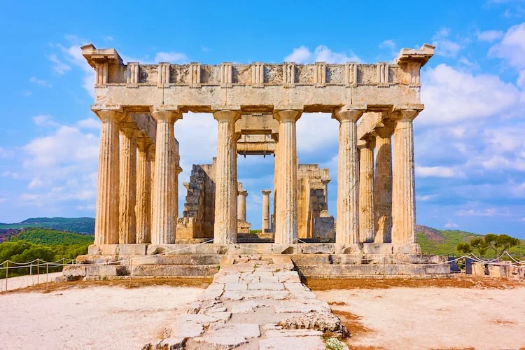
The Temple of Aphaia, perched high on a pine-covered ridge on the island of Aegina, stands as one of the most brilliant architectural and sculptural masterpieces of Archaic Greece. Looking out over the Saronic Gulf toward Athens, this remarkably well-preserved sanctuary marks the precise structural pivot point where traditional, rigid Archaic design evolved into the fluid harmony of the Classical style.

What makes this temple truly captivating to historians and archaeologists is its dedication to a mysterious, highly localized goddess found nowhere else in Greece, alongside the dramatic, competitive story told by its famous pediment sculptures.

1. The Mysterious Goddess: Who was Aphaia?

While major temples throughout Greece were usually dedicated to pan-Hellenic heavyweights like Zeus, Apollo, or Athena, the people of Aegina directed their highest devotion on this ridge to Aphaia.

According to local mythology recorded by the writer Pausanias, Aphaia was originally a beautiful Cretan semi-divinity named Britomartis, a favorite companion of the huntress goddess Artemis. To escape the aggressive, unwanted romantic advances of King Minos of Crete, Britomartis leaped off a cliff into the sea.

She was rescued by the nets of Aeginetan fishermen, but when one of the fishermen also became infatuated with her, she fled up into the remote mountain groves of Aegina. When her pursuers closed in, she miraculously vanished into thin air.

The Invisible Lady: The local population deified her on the spot, naming her Aphaia, which translates directly from ancient Greek as "The Invisible One" or "The Vanished One." Her cult was ancient, dating back to prehistoric times as a fertility and nature goddess. As Aegina grew into a dominant maritime and political power in the 6th century BCE, the islanders completely rebuilt her rustic mountain shrine into a grand, stone sanctuary to showcase their wealth and independent identity.

2. Architectural Mastery: The Transition to Classical Harmony

The temple we see standing today was constructed around 500–475 BCE, built directly over the charred remains of an earlier Archaic temple that had burned down.

Constructed out of local Poros limestone (originally coated in a fine, smooth plaster made of marble dust and painted in vibrant colors), the building is a Doric peripteral temple, featuring a grid of 6 columns across the front and back, and 12 columns running down the sides ($6 \times 12$).

The architecture of the Temple of Aphaia is a masterclass in early optical refinement, showing that Greek architects were moving away from rigid mathematical formulas to design for the flaws of human vision:

  • The Inward Lean: To prevent the heavy stone building from appearing top-heavy or unstable to a viewer standing below, the exterior columns are engineered with a subtle inward inclination.

  • The Corner Thickening: The columns on the absolute corners of the temple are made slightly thicker than the inner columns. This adjustment compensated for the fact that corner columns are silhouetted against the bright, open sky, which visually tricks the human eye into making them look thinner than they actually are.

  • The Double-Tiered Cella: Inside the inner chamber (cella) where the sacred cult statue stood, the architects designed a beautiful, space-saving layout featuring two internal rows of columns arranged in a double tier—one smaller set of columns stacked directly on top of a larger lower set—to support the heavy wooden roof beams without blocking the interior view.

3. The Great Pediment Rivalry: Archaic vs. Classical Style

The absolute artistic climax of the Temple of Aphaia lies in its pediments—the large, triangular gables at the eastern and western ends of the roof line line. These pediments housed a series of life-sized, free-standing marble sculptures that were discovered in 1811 and are now housed in the Glyptothek in Munich, Germany.

Both pediments depict a legendary military theme highly dear to Aeginetan pride: the Trojan Wars. Specifically, they showcase Aeginetan heroes like Telamon and Ajax fighting alongside Heracles and King Agamemnon against the Trojans.

Remarkably, the two pediments were carved just a couple of decades apart, yet they represent a massive, tectonic shift in the history of Western art.

The West Pediment (c. 500 BCE) – The Late Archaic Style

The West Pediment was carved first. Even though the scenes depict a violent, chaotic bloodbath of warriors clashing with spears, the sculptures are bound by rigid Archaic conventions.

  • The Dynamic: The figures move along a flat, two-dimensional plane, looking like stiff puppets frozen in place.

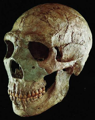
  • The Archaic Smile: Most famously, a fallen warrior on the far left, depicted with an arrow sticking straight out of his chest, lies dying while staring directly out at the audience with a blank, eerie, and stylized Archaic smile. To the Archaic sculptor, the smile was a symbolic convention used to show that the character was alive and conscious, completely overriding the physical and psychological reality of agony and death.

The East Pediment (c. 480 BCE) – The Early Classical (Severe) Style

The East Pediment was carved later, likely to replace an earlier set damaged during a military conflict. In the short span of roughly twenty years, Greek art completely transformed.

  • The Dynamic: The figures on the East Pediment break free of the flat plane, twisting, lunging, and collapsing in realistic, three-dimensional space with complex anatomical movement (contrapposto).

  • The Psychological Realism: The dying warrior on the East Pediment does not smile. He faces down toward the earth, his body heavily sagging into his shield, his leg muscles straining, and his face contorted in a realistic, stoic expression of pain and fading strength. The art had abandoned stiff symbolism to capture genuine human psychology and physical gravity.

4. The Sacred Triangulation of the Saronic Gulf

Beyond its internal architecture, the Temple of Aphaia participates in a grand, regional geographic design. In the 20th century, topographers and historians noted that the Temple of Aphaia on Aegina forms a nearly perfect isosceles triangle with two of the greatest sanctuaries on the Greek mainland: the Parthenon on the Athenian Acropolis and the Temple of Poseidon at Sounion.

                         [ The Parthenon (Athens) ]
                                    / \
                                   /   \
                                  /     \
                                 /       \
                                /         \
    [ Temple of Aphaia (Aegina) ] --------- [ Temple of Poseidon (Sounion) ]

This phenomenon, often referred to as the Sacred Triangle of the Aegean, demonstrates that classical Greek sanctuaries were not built at random. Their placement was carefully calculated based on visual sightlines, territorial boundaries, and sacred geometry, ensuring that a sailor navigating the treacherous waters of the Saronic Gulf was almost always within visual layout of a major monument of divine protection.

The Temple of Aphaia stands as a vital missing link in our understanding of antiquity. By preserving the exact architectural transition where the stiff, symbolic rules of the Archaic age gave way to the humanism, anatomy, and psychological depth of the High Classical era, this mountain sanctuary ensures that the name of the "Invisible Goddess" remains permanently etched into the story of human art.

The Minoan Civilization: The Cult of the Mother Goddess

June 14, 2026

Unlike their successors on the Greek mainland, who worshipped a highly patriarchal pantheon led by thunderbolt-wielding Zeus, the Bronze Age Minoans of Crete directed their highest spiritual devotion toward the feminine.

At the absolute center of Minoan religion was a powerful, multi-faceted nature deity often referred to by historians as the Mother Goddess or Great Goddess. Her cult dominated palatial life, driving a religious culture that celebrated fertility, the natural world, cosmic sovereignty, and the ecstatic connection between humanity and the divine.

1. Epiphany and Nature: The Identity of the Goddess

The Minoans did not leave behind readable mythological texts—their script, Linear A, remains untranslated. Consequently, our entire understanding of the Mother Goddess comes from their vibrant, exceptionally preserved visual art.

Minoan art suggests that the Mother Goddess was not a distant, abstract celestial entity, but an immanent force deeply woven into the earth, the sea, and the sky. She frequently appears in multiple specialized iconography roles:

  • The Mistress of Animals (Potnia Theron): The Goddess is routinely depicted flanked by heraldic lions, griffins, or hunting hounds, demonstrating her absolute sovereignty over the wild, untamed forces of nature.

  • The Mountain Mother: In many seal impressions, she is shown standing proudly atop a rugged mountain peak, holding out a staff of authority while priests or worshippers bow below her.

  • The Vegetation Goddess: She is frequently depicted sitting beneath sacred trees (such as olive or fig trees), receiving offerings of fruits and grain, tying her cult directly to agricultural fertility and the cyclical rebirth of the seasons.

2. Iconic Manifestations: The Snake Goddesses

The most famous physical representations of this cult are the faience Snake Goddess figurines excavated from the temple repositories of the palace of Knossos, dating to around 1600 BCE.

These figurines offer an intimate look at the symbolic vocabulary of the cult:

  • The Chthonic Snakes: The goddess (or her high priestess) holds writhing snakes aloft in her bare hands. In the ancient Mediterranean, the snake was a profound chthonic (earth-bound) symbol. Because snakes shed their skins, they represented rebirth, immortality, and the cyclic nature of life, while also linking the goddess to the deep, subterranean forces of the earth (crucial for an island prone to earthquakes).

  • The Feline Crown: On one prominent figurine, a small leopard or cat sits perched atop her elaborate headdress, re-emphasizing her dominion over animal life.

  • The Flounced Skirt and Exposed Breasts: She wears the traditional, high-status Minoan court dress, featuring an intricately layered, flounced skirt and a tight bodice that exposes her bare breasts. This stylistic choice underscored her role as a source of universal nourishment, maternity, and life-giving fertility.

3. Ritual Spaces: From Peaks to Palaces

The Minoans did not construct massive, isolated temples like the later classical Greeks. Instead, the cult of the Mother Goddess operated within the natural landscape and the architectural hearts of their communities.

Peak Sanctuaries and Sacred Caves

The Minoans traveled out of their cities to worship the goddess at peak sanctuaries—open-air shrines built on the summits of prominent mountains, such as Mount Juktas. Here, worshippers lit massive bonfires and left behind clay votive offerings shaped like human limbs, cattle, and sheep, praying for healing or agricultural abundance.

They also descended into deep, dark sacred caves (like the Psychro Cave, traditionally associated with the birth of Zeus in later myth). In these damp, stalactite-filled underworld caverns, they deposited costly bronze daggers, double axes, and pottery filled with honey and oil directly into the rock crevices.

Palatial Shrines

Within palaces like Knossos and Phaistos, the goddess occupied central, subterranean rooms known as Lustral Basins and Pillar Crypts.

The Pillar Crypts were dark, windowless rooms centered around one or two massive stone pillars incised with sacred symbols. Priests would pour liquid offerings (libations) of wine, milk, or bull's blood into channels carved into the stone floor surrounding the pillar, feeding the goddess within the structural foundations of the state.

4. Ecstatic Rituals and the Sacred Epiphany

Minoan religious worship was a highly dynamic, participatory affair. To communicate with the Mother Goddess, her priestesses and worshippers engaged in ecstatic rituals designed to trigger a divine epiphany—the literal, temporary manifestation of the goddess on earth.

  • Sacred Tree-Shaking and Rock-Clasping: Gold signet rings depict ecstatic priestesses violently shaking sacred trees or weeping over large boulders. These physical acts were meant to draw the cosmic energy of the goddess out of the natural object.

  • Ecstatic Dance: Large frescoes depict crowds of women performing highly stylized, rhythmic circle dances in open-air palace courtyards. Accompanied by flutes and lyres, these frenzied dances likely induced altered states of consciousness, allowing the high priestess to channel the voice and presence of the deity.

5. The Double Axe (Labrys) and Sacred Bull

The cult of the goddess was flanked by two ubiquitous, powerful symbols whose true meanings remain a subject of intense academic debate:

  • The Labrys: The double-headed axe was the supreme holy symbol of the Minoan world. Giant bronze labryes mounted on stepped bases stood inside every shrine. Crucially, the double axe is almost exclusively held by women or the goddess herself in Minoan iconography, suggesting it functioned as a scepter of feminine spiritual authority rather than a weapon of war.

  • The Bull: While the bull represented raw, masculine strength, cosmic storm power, and sacrifice, it remained subordinate to the feminine in Minoan art. In the famous bull-leaping frescoes, young men and women acrobatically vault over the charging beast together, transforming a wild, dangerous force into a sacred, ritualized performance dedicated to the entertainment of the Goddess.

6. The Transition: The Mycenaean Synthesis

When the highly militaristic Mycenaean Greeks conquered Crete around 1450 BCE, they did not wipe out the cult of the Mother Goddess. Instead, they absorbed her into their own evolving religious system.

Linear B tablets from Knossos and Pylos list offerings made to the Potnia (the Mistress or Lady), showing that the Mycenaeans adopted the Minoan goddess of nature, but partitioned her into specialized, localized deities. This Bronze Age fusion permanently shaped the classical Greek pantheon, splitting the multi-faceted Minoan Mother Goddess into distinct mythological figures: Demeter inherited her agricultural fertility, Artemis took her sovereignty over wild animals, and Athena adopted her protective, urban palace authority.

Roman Urban Life: The Insulae and the Housing of the Poor

June 14, 2026

While the wealthy elites of ancient Rome lounged in sprawling, single-family townhouses (domus) or luxurious countryside villas, the vast majority of Rome's urban population lived a radically different reality.

To house an unprecedented metropolis of over one million people, Roman architects engineered the insula (plural: insulae—literally meaning "islands"). These multi-story, high-density apartment blocks were the true engines of Roman urban life. They were overcrowded, structurally volatile, and profoundly unequal, serving as a stark architectural reflection of the Roman class divide.

1. The Anatomy of an Insula

An insula was a multi-tiered apartment complex that took up an entire city block, surrounded on all sides by the narrow, chaotic streets of Rome. Typically rising between five to seven stories high, these structures operated on a strict vertical hierarchy of wealth: the higher you climbed, the poorer you were.

The Ground Floor (Tabernae)

The ground level was premium real estate. It featured a series of open-fronted shops and workshops called tabernae, where artisans hammered metal, bakers sold bread, and hot-food cafes (thermopolia) served the public. The back or mezzanine levels of these shops often housed the shopkeeper's family.

The Upper Levels (Cenacula)

Above the shops sat the apartments (cenacula).

  • The Low-Level Luxury: The first and second floors featured spacious, high-ceilinged apartments with multiple rooms and sturdy concrete balconies. These were rented out to well-to-do merchants or minor aristocrats.

  • The High-Level Slums: As the staircases narrowed and ascended, the apartments deteriorated into dark, single-room cubicles called pergulae. These attic rooms were rented out by the day or week to Rome’s poorest citizens: dockworkers, weavers, prostitutes, and destitute immigrants.

2. Structural Instability and the Concrete Scams

Living in an insula was a highly hazardous gamble. Because land prices in central Rome were astronomical, speculative landlords and corrupt contractors sought to maximize their profits by building as high as possible while spending as little as possible on materials.

Instead of utilizing expensive, fireproof kiln-baked bricks and high-quality volcanic concrete, contractors frequently constructed insulae out of opus craticium—a cheap, flimsy framing method consisting of a lattice of wooden laths covered in mud plaster.

Furthermore, to save money, landlords built walls incredibly thin and skimped on foundations. As a result, structural collapse was a daily occurrence in Rome. The contemporary writer Juvenal famously joked that Roman landlords propped up their rotting buildings with flimsy wooden beams, telling the tenants to sleep soundly while the walls were on the verge of cave-in.

3. The Constant Terror: Fire in the Metropolis

If structural collapse didn't claim an insula, fire inevitably did. The upper floors of an insula lacked any form of running water or ventilation. To survive the winter or cook a meal, tenants relied entirely on open charcoal braziers, portable oil lamps, and torches.

When you combine thousands of open flames with highly flammable wooden frameworks, dry thatch roofs, and overcrowded rooms, the result was a permanent urban powder keg.

Because there were no building codes or zoning laws for centuries, insulae were built incredibly close together. If a fire broke out on the ground floor of an insula, it would tear upward through the wooden staircases like a chimney.

Because there were no fire escapes and the windows were tiny, the poor living in the attic apartments were completely trapped. While the rich on the ground floor could step out onto the street instantly, the poor were frequently burned alive or forced to jump to their deaths.

4. Daily Life: No Water, No Toilets, No Kitchens

For the Roman poor, the apartment block was not a cozy sanctuary; it was merely a place to sleep. The physical limitations of the upper-floor cenacula forced human life out into the public squares:

  • The Plumbing Void: Only the wealthy ground-floor tenants had direct hookups to Rome’s famous aqueduct system and public sewer lines (Cloaca Maxima). The poor had to carry heavy ceramic jars of water up multiple flights of steep stairs.

  • The Chamber Pot Dilemma: Without toilets, tenants used communal earthenware chamber pots. While some would carry these down to the street to empty them into public vats, many took the lazy, highly illegal route of dumping their waste straight out the window into the narrow alleys below, routinely drenching passing pedestrians.

  • The Public Diet: Because the upper floors lacked kitchens and proper chimneys, cooking at home was a massive fire hazard. Consequently, the Roman working class rarely ate at home. They relied almost entirely on the street-food culture of Rome, buying cheap stews, lentil porridges, and coarse bread from local thermopolia.

5. The Imperial Reforms: Post-64 CE

The total vulnerability of the insulae system was laid bare during the Great Fire of Rome in 64 CE, which destroyed huge swathes of these wooden apartment blocks. Following the disaster, Emperor Nero implemented Rome's first comprehensive urban planning and building safety codes:

  • He banned the use of flammable wooden opus craticium for exterior walls, mandating fire-resistant volcanic tufa stone instead.

  • He capped the legal height of insulae to roughly 60–70 Roman feet (about 5 to 6 stories) to prevent collapses and allow for easier firefighting.

  • He mandated that all new apartment blocks be built with open, stone-vaulted porticoes along the front facades, providing wider streets to act as natural firebreaks and ensuring clear evacuation routes for tenants.

Despite these imperial upgrades, the insulae remained symbols of systemic urban inequality. They allowed Rome to pack over a million people into a tight geographic footprint, creating a vibrant, chaotic, and hyper-dense street culture that served as the true heart of the empire—proving that while the legions conquered the world, it was the working-class poor crammed into stone-and-wood islands who kept the capital running.

The Viking Age Ship Building: The Clinker-Built Technique

June 13, 2026

The supreme catalyst for the Viking Age was not a political ideology or a religious upheaval—it was a technological masterpiece of naval engineering: the Viking Longship.

At the absolute core of Scandinavian maritime supremacy was a specialized construction method known as the clinker-built (or lapstrake) technique. This engineering tradition produced vessels that were uniquely lightweight, exceptionally strong, and incredibly flexible, allowing the Norsemen to cross the open, violent waters of the Atlantic while also navigating shallow, inland river networks deep within Europe.

1. The Anatomy of Clinker Construction

For centuries, Mediterranean shipbuilders relied on carvel construction, where wooden hull planks were placed flush, edge-to-edge, over a heavy, pre-built internal skeleton. The Vikings inverted this process entirely, building the shell of the ship first.

In clinker construction, the hull planks (strakes) are laid down starting from the keel and worked upward. Crucially, each new plank overlaps the upper edge of the plank beneath it.

The Fastening Process

To bind these overlapping planks together, Viking shipwrights used a highly effective fastening system:

  • Iron Rivets: They drilled small holes through the overlapping sections of the oak or pine strakes and drove square-sectioned iron rivets (roving nails) through them. On the inside of the hull, they placed a small, flat iron washer called a rove over the tip of the nail and hammered it flat, effectively clamping the two planks together in an unbreakable, watertight grip.

  • Waterproof Caulking: Before tightening the rivets, the shipwrights stuffed a mixture of tarred animal hair (usually horsehair or sheep's wool) or moss into the overlapping joints to serve as a highly durable waterproof sealant.

2. Cleaving the Wood: The Radial Splitting Technique

The strength of a clinker-built ship began long before a single rivet was driven; it started with how the Vikings harvested their timber.

Viking craftsmen did not use saws to cut logs into planks. Saws cut straight through a tree regardless of the wood's natural grain, which severs the internal fibers and creates brittle, easily cracked boards. Instead, the Vikings utilized radial splitting.

Using iron wedges, wooden mallets, and axes, shipwrights split massive green oak logs down the center, then into quarters, eighths, and sixteenths, radiating outward from the central pith like the spokes of a bicycle wheel.

This produced thin, wedge-shaped planks that followed the tree's natural, continuous grain. These planks were remarkably strong, highly resistant to splitting, and naturally warped less when drying, allowing the hull to be incredibly thin—often just an inch thick—without sacrificing structural integrity.

3. The Skeleton: Internal Flexibility

Only after the outer shell of overlapping strakes was fully built up did the shipwrights insert the internal framework.

They fitted curved wooden ribs (wrongs) across the inside of the hull to provide cross-sectional support. However, instead of rigidly nailing or bolting these ribs to the hull, the Vikings traditionally tied them to the strakes using flexible cleat ties made of spruce roots, leather thongs, or willow withes.

   [Outer Hull Strake] ─── (Overlaps next strake)
          │
     [Iron Rivet] ─────── (Clamps planks tight)
          │
   [Flexible Tie] ─────── (Binds strake loosely to inner rib)
          │
   [Internal Rib] ─────── (Provides cross-sectional support)

This deliberate lack of rigid internal fastening was a stroke of engineering genius. When a Viking longship encountered massive ocean waves, the entire hull did not resist the water with rigid brute force; instead, it twisted, flexed, and bent with the contours of the sea. This organic elasticity prevented the hull from snapping under the violent hydrostatic pressure of the North Atlantic.

4. The Keel and the True Steer-Board

The backbone of the entire structure was the keel, carved from a single, massive, straight-grained oak tree. The keel was shaped like a broad "T" or "Y" to provide a rock-solid anchor for the strakes while acting as a structural shock absorber if the ship ran aground.

To propel and steer these flexible hulls, the Vikings integrated two crucial features:

  • The Keel’s Hydrodynamics: The deep, solid keel acted as a massive underwater fin. This allowed the longship to handle a colossal square sail without capsizing, enabling the ship to sail efficiently into the wind (tacking) rather than just running before it.

  • The Steer-Board: Longships did not have central rudders. Instead, they utilized a large, wing-shaped steering oar fixed exclusively to the right-hand side of the stern. This custom-engineered oar was attached via a flexible leather strap and a wooden block, allowing the helmsman highly responsive control. This side of the ship became known as the stýriborð—the linguistic origin of our modern nautical term starboard.

5. Strategic Dominance: Deep Oceans and Shallow Rivers

The ultimate synthesis of radial splitting, clinker planking, and internal flexibility resulted in a vessel with a radically low draft (the depth of the ship below the waterline).

Even a massive, 100-foot-long troop transport carrying dozens of fully armored warriors drew only about three feet of water.

This structural duality changed the face of medieval warfare:

  1. The Ocean Crossing: The flexibility of the clinker hull allowed them to survive fierce ocean storms, paving the way for voyages to Iceland, Greenland, and Newfoundland.

  2. The Shallow Raid: The ultra-shallow draft meant the ships could sail straight over coastal sandbars and navigate shallow river networks deep into the continental interiors of France, England, and Russia.

  3. The Instant Beaching: Longships did not require deep-water harbors or docks. They could be rowed directly onto any flat, sandy beach. Warriors could leap straight out of the bows into battle, and if a retreat was necessary, the perfectly symmetrical design allowed the ship to be rowed backward instantly without turning around.

The clinker-built technique was so structurally successful that it remained the dominant boat-building tradition of Northern Europe for over a millennium. Today, the iconic lines of the clinker hull—immortalized in recovered archaeological treasures like the Oseberg and Gokstad ships—stand as a testament to an era when a simple shift in woodworking geometry allowed a seafaring culture to redraw the geopolitical map of the Western world.

Ancient Egyptian Temples: The Temple of Kom Ombo and the Crocodile God

June 13, 2026

Rising directly from the eastern banks of the Nile River, roughly 30 miles north of Aswan, stands the Temple of Kom Ombo. Built during the Ptolemaic Dynasty (180–47 BCE) with later Roman additions, this temple is unique in the ancient world.

While almost all Egyptian temples were dedicated to a single deity or a traditional triad, Kom Ombo was designed as a perfectly symmetrical double temple. It was built to appease two entirely separate, conflicting theological forces: Horus the Elder (Haroeris), the benevolent god of light, and Sobek, the terrifying, unpredictable crocodile god of the Nile.

1. The Geography of Fear: Why the Crocodile?

To understand Kom Ombo, one must understand its specific geographic location. In antiquity, the loop of the Nile River surrounding the town of Ombo was a natural, swampy haven for thousands of Nile crocodiles. These massive predators posed a constant, deadly threat to local fishermen, farmers, and washing women.

Rather than trying to eradicate the threat, the ancient Egyptians engaged in a classic strategy of religious pacification. They deified the creature as Sobek, viewing the crocodile as the living manifestation of the Nile's raw, chaotic, and creative power.

By worshipping Sobek at Kom Ombo, the Egyptians believed they could tame his ferocity, ensure the annual fertile flooding of the Nile, and transform a deadly predator into a fierce divine protector of the pharaoh.

2. Architectural Symmetry: The Dual Design

The theological challenge of housing two rival gods under one roof was solved by the Ptolemaic architects through an absolute commitment to axial symmetry. The temple is literally split down the middle along a central line, creating two parallel sacred spaces running side-by-side.

Everything in the temple is perfectly duplicated:

  • Two Entrances: The front pylon features two identical monumental gateways. The left gateway was used exclusively for rituals honoring Horus, while the right gateway belonged to Sobek.

  • The Shared Spaces: The temple features a shared outer courtyard and two successive hypostyle halls. However, even within these communal rooms, the columns and reliefs on the northern half are dedicated to Horus, while the southern half is entirely dominated by Sobek.

  • Twin Sanctuaries: At the deepest, most sacred core of the complex sit two identical, mirror-image inner sanctuaries (naos). Here, the cult statues of the two gods sat side by side, separated only by a thick stone partition wall.

3. The Cult of Sobek and the Sacred Crocodiles

The southern wing of Kom Ombo was a living, breathing habitat for real crocodiles. The temple complex featured a sacred, deep stone basin connected directly to the Nile, known as the Crocodile Well.

Here, temple priests raised a single, physically pristine crocodile chosen to be the living earthly vessel of Sobek. This "sacred crocodile" was pampered with ultimate luxury: adorned with gold earrings and bracelets on its forefeet, and fed a rich diet of choice meats, cakes, and honey by the priests.

When this sacred animal died, it was treated with the exact same funerary honors as a high-ranking human noble. The body was painstakingly mummified, wrapped in fine linen sheets, and laid to rest in a dedicated subterranean animal cemetery nearby.

Today, the modern Crocodile Museum, located right outside the temple exit, houses dozens of these exceptionally preserved ancient crocodile mummies, ranging from massive adults over 15 feet long to tiny, fragile hatchlings and fossilized crocodile eggs.

4. Science on the Nile: Medicine and the Nilometer

Beyond its dark, reptilian theology, Kom Ombo functioned as a major hub for ancient Egyptian science, mathematics, and medicine. Two specific features on the temple grounds highlight this empirical legacy:

The Surgical Reliefs

Carved onto the back of the temple’s inner enclosure wall is one of the most famous medical inscriptions in the world. The relief depicts a highly advanced kit of medical and surgical instruments being presented to a seated god.

Egyptologists have identified highly specific tools within this stone catalog, including scalpels, bone saws, forceps, dental probes, retractor hooks, surgical scissors, and scales for weighing medicinal dosages. This relief suggests that the outer courtyards of Kom Ombo likely operated as a major regional hospital and medical school under the priesthood.

The Deep Nilometer

Located just outside the northern wall is a massive, circular stone well plunging deep into the bedrock. This was a Nilometer.

Priests would look down into the well to read calibrated numerical marks carved into the stone walls, allowing them to measure the exact height of the Nile’s water table during the flood season. If the Nilometer showed a high water level, it predicted a bumper crop harvest, allowing the pharaoh's tax collectors to calculate the coming year's agricultural taxes with mathematical precision.

5. Summary of the Dual Theology

  • Northern Axis (Horus the Elder): Represents light, cosmic order (Ma'at), rational medicine, and solar protection. Associated with healing and divine kingship.

  • Southern Axis (Sobek): Represents the dark, fertile waters of the Nile, raw physical power, fertility, and unpredictable chaos. Associated with military might and pacifying the wild.

The Temple of Kom Ombo stands as a fascinating monument to Egyptian pragmatism. Rather than ignoring the terrifying realities of their environment or viewing nature as a singular benevolent force, the builders of Kom Ombo crafted a dual architecture that allowed humanity to walk the fine line between light and dark, science and fear, safely on the banks of the Nile.

The Roman Emperor Constantine: The Arch of Constantine and the Christian Empire

June 13, 2026

The reign of Emperor Constantine the Great (306–337 CE) stands as one of the most critical turning points in world history. By halting the brutal persecution of Christians and personally adopting the faith, Constantine initiated the transformation of the Roman Empire from a pagan superpower into a Christian state.

This dramatic religious and political shift is frozen in stone at the heart of Rome’s monumental center through the Arch of Constantine. Erected in 315 CE to celebrate his ten-year jubilee and his definitive victory at the Battle of the Milvian Bridge, this triumphal arch acts as a fascinating, contradictory bridge between Rome's classical pagan past and its medieval Christian future.

1. The Crucible: The Milvian Bridge and the Vision

In the early 4th century, the Roman Empire was fractured by a chaotic civil war. Constantine marched on Rome to confront his rival, Maxentius, who held the capital.

According to the Christian historian Eusebius, on the afternoon of October 27, 312 CE—the day before the historic Battle of the Milvian Bridge—Constantine looked up at the sun and witnessed a miraculous vision: a cross of light emblazoned against the sky, accompanied by the Greek words En Touto Nika ("In this sign, conquer").

Constantine ordered his soldiers to paint the Chi-Rho (a monogram of the first two letters of Christ’s name in Greek, $\chi$ and $\rho$) onto their shields. The next day, Constantine’s forces smashed Maxentius’s army, driving them into the Tiber River.

The very next year, in 313 CE, Constantine co-issued the Edict of Milan, which granted absolute religious toleration to Christians across the empire, legally ending centuries of state-sanctioned martyrdom.

2. The Arch of Constantine: Architectural Recycling

Standing directly alongside the Colosseum, the Arch of Constantine is the largest surviving triumphal arch from antiquity. However, it is structurally unique because it is a massive architectural collage.

Instead of carving entirely new reliefs, Constantine’s architects engaged in spolia—the systematic stripping of older, iconic monuments dedicated to Rome’s greatest 2nd-century "Good Emperors": Trajan, Hadrian, and Marcus Aurelius.

  • The Trajanic Reliefs: Massive battle scenes showing Roman soldiers crushing barbarians were taken from Trajan's Forum and repurposed to frame Constantine’s victories.

  • The Hadrianic Roundels: Large, circular reliefs showing Hadrian hunting wild boars and sacrificing to pagan gods like Apollo and Diana were set into the brickwork.

  • The Aurelian Panels: Rectangular reliefs depicting Marcus Aurelius executing military duties and practicing traditional civic virtues were mounted on the upper attic level.

Why Reuse Old Art?

For centuries, art historians viewed this heavy reliance on spolia as a symptom of artistic decline, assuming 4th-century Rome simply lacked skilled sculptors. Modern archaeology, however, views it as a brilliant stroke of political propaganda.

By physically stitching the stone bodies of Trajan, Hadrian, and Marcus Aurelius to his own monument, Constantine was telling the public that he was the spiritual and political heir to Rome's golden age. Furthermore, his artisans carefully recarved the stone faces of the past emperors to match Constantine’s distinct, wide-eyed portrait.

3. The Shift in Art: The Constantinian Frieze

Directly underneath the smooth, classical Hadrianic roundels runs a narrow, horizontal band of completely original 4th-century sculpture: the Constantinian Frieze.

The stylistic contrast between the older reused art and Constantine’s new art is jarring. While the 2nd-century panels focus on realistic anatomy, fluid movement, and three-dimensional depth, the Constantinian carvings are flat, rigid, and highly geometric. Figures are short, blocky, and arranged in repetitive, static rows.

This change was not an accident; it marks the birth of Late Antique and Medieval Art. The focus shifted away from the physical realism of the pagan world toward a highly legible, symbolic language. On the frieze, Constantine sits perfectly centered, elevated, and larger than the uniform crowd below him. The art no longer cared about matching physical reality; its sole job was to communicate absolute hierarchy, divine authority, and the immovable order of the state.

4. The Deliberate Religious Ambiguity

Given Constantine's status as the champion of Christianity, the arch features a glaring omission: there is not a single explicit Christian symbol on it. There are no crosses, no Chi-Rhos, and no mentions of Jesus Christ.

Instead, the monument features a highly calculated, deliberate religious ambiguity designed to appease both a deeply conservative, pagan Roman Senate and an expanding Christian populace.

  • The Inscription: On the central attic inscription, the Senate wrote that Constantine defeated the tyrant Maxentius "instinctu divinitatis"—"by the prompting of the divinity." This phrase was genius compatibilism. A pagan viewer could interpret it as the traditional sun god (Sol Invictus) or Jupiter, while a Christian viewer knew exactly which unnamed, singular God it referred to.

  • The Sun God Presence: The arch prominently features reliefs of Sol Invictus, the Unconquered Sun, driving his chariot across the sky. Constantine was an expert syncretist; for the first half of his reign, he seamlessly blended the imagery of Christ with the imagery of the Sun God, even declaring Sunday (the day of the sun) as the official Roman day of rest.

5. Moving the Center: From Rome to Constantinople

Ultimately, the Arch of Constantine represents a farewell to the old capital. Constantine quickly realized that Rome, with its deep-seated pagan traditions, entrenched senatorial elite, and outdated geographic position, could no longer serve as the command center for a reformed, Christian empire.

In 330 CE, Constantine officially moved the capital of the empire eastward to the ancient Greek city of Byzantium, completely rebuilding it and naming it after himself: Constantinople (modern-day Istanbul).

While the city of Rome began its slow slide into the Middle Ages, the Arch of Constantine stood as a permanent stone anchor left behind—a monument that utilized the stolen architectural triumphs of Rome's pagan peak to legitimize the ruler who would dismantle it in favor of a global Christian empire.

Ancient Greek Pottery: The Attic Black-Figure and Red-Figure Styles

June 13, 2026

The transformation of Athenian ceramic art during the 6th and 5th centuries BCE represents one of the most spectacular leaps in the history of visual art. Centered in the Kerameikos (the potters' quarter of Athens), ancient artisans advanced from rigid, geometric patterns to fluid, hyper-detailed human narratives.

This artistic evolution is defined by two revolutionary, opposing techniques that dominated the Mediterranean luxury market: Black-Figure and Red-Figure pottery.

1. The Canvas: The Three-Phase Firing Process

Before exploring the styles, it is essential to understand the chemistry that made them possible. Ancient Greek pottery did not use colored paints or glazes. Instead, the rich black and orange-red colors were achieved through a highly sophisticated, single-firing process that manipulated the oxygen levels inside the kiln.

This Three-Phase Firing relied entirely on an iron-rich liquid clay slip applied by the artist:

  • Phase 1: Oxidizing (The Fire): The kiln was heated to roughly 800°C with plenty of ventilation. Oxygen flooded the chamber, turning both the raw pot and the painted clay slip a uniform, vibrant red color ($Fe_2O_3$, ferric oxide).

  • Phase 2: Reducing (The Smothering): The potter closed the ventilation holes and tossed green wood or damp leaves into the fire, raising the temperature to 950°C. This created a smoky, oxygen-starved environment rich in carbon monoxide. The entire vessel turned jet-black ($Fe_3O_4$, magnetic iron oxide), and the painted slip chemically vitrified (melted into a smooth, glassy, impermeable layer).

  • Phase 3: Re-oxidizing (The Cooling): The ventilation gates were reopened, allowing oxygen back into the cooling kiln. The unpainted, porous clay absorbed the oxygen and turned back to its natural, terracotta orange-red. However, the vitrified black slip was completely sealed; it could not re-absorb oxygen and remained a glossy, deep metallic black.

2. The Black-Figure Style (c. 620–500 BCE)

Developed originally in Corinth but perfected to its absolute zenith in Athens (Attica), the Black-Figure technique dominated the 6th century BCE.

The Technique

The artist painted the silhouettes of figures onto the unbaked, red clay vessel using the iron-rich liquid slip. Once dry, the artist used a sharp, metal stylus to physically incise (scratch) fine lines through the black slip, revealing the raw red clay underneath. This allowed them to render internal details like muscles, eyes, armor patterns, and hair strands.

Key Characteristics and Masters

  • The Look: Figures appear as stark, sharp black silhouettes against an orange-red background. Painters often added white slip to represent women's skin and purple-red slips to accent garments or blood.

  • Exekias (The Master): The undisputed genius of black-figure was Exekias. His most famous work, the Vatican Amphora, depicts the heroes Achilles and Ajax playing a board game during a break from the Trojan War. Exekias captured unprecedented psychological tension purely through the precision of his incised lines, tracing microscopic details into their cloaks and hair.

3. The Red-Figure Style (c. 530–400 BCE)

Around 530 BCE, an anonymous craftsman in the workshop of the potter Andokides asked a radical question: What happens if we invert the entire process? This intellectual pivot birthed the Red-Figure style, which quickly rendered black-figure obsolete.

The Technique

Instead of painting the figures, the artist drew the outlines of the characters and then painted the entire background black, leaving the figures themselves as the raw, unpainted red clay.

Crucially, instead of using a sharp stylus to scratch away details, the artist used fine, delicate brushes or hair-tipped syringes to draw anatomical lines directly onto the red figures using varying thicknesses of the liquid slip.

The Artistic Revolution

By replacing the rigid stylus with a fluid brush, red-figure shattered the boundaries of Bronze and Archaic art:

  • Anatomical Realism: Artists could now vary the dilution of the slip. A thick application created a bold, raised black line, while a watered-down glaze created a soft, golden-brown wash perfect for rendering subtle muscle definition, soft drapery folds, and individual strands of hair.

  • Foreshortening and Perspective: For the first time in Western art, figures were no longer trapped in strict profile views. Painters like Euphronios experimented with foreshortening—drawing limbs, shields, and torsos twisting in three-dimensional space, capturing realistic movement and overlapping perspective.

4. Summary of Artistic Differences

  • Black-Figure Technique: Figures are painted black; details are scratched in with a sharp stylus; art style is rigid, monumental, and formal.

  • Red-Figure Technique: Background is painted black; details are drawn on with a fluid brush; art style is dynamic, capturing perspective, realism, and daily life.

5. The "Pioneer Group" and the Potter's Pride

The transition to red-figure sparked an era of intense, playful competition among Athenian artists. A group of contemporary painters, calling themselves the Pioneer Group (including Euphronios, Euthymides, and Phintias), used their pottery as a canvas for artistic experimentation and personal rivalries.

They moved beyond purely mythological battles to paint raw, contemporary scenes of Athenian life: sweaty wrestlers at the gymnasium, chaotic drinking parties (symposia), and artisans working in workshops.

They were highly literate and frequently signed their pots with phrases like "Euphronios egrapsen" (Euphronios painted it). On one famous amphora, Euthymides painted a group of revellers dancing and proudly inscribed a direct taunt to his chief rival across the workshop floor: "As Euphronios never could!"

Through this intense commercial and artistic rivalry, the potters of Athens transformed utilitarian kitchenware into the premier luxury export of the ancient world, establishing the foundational rules of perspective and anatomy that would later guide the high art of Western civilization.

The Mycenaean Civilization: The Trade in Perfumed Oils and Pottery

June 13, 2026

The Mycenaean Greeks—the Late Bronze Age warriors who dominated the Aegean from roughly 1600 to 1100 BCE—built an empire on more than just military conquest. At its peak, Mycenaean civilization operated as a highly centralized, bureaucratic commercial machine.

Driven by the palatial administrative centers like Mycenae, Pylos, and Tiryns, the Mycenaeans established an aggressive maritime trade network. The lifeblood of this economic empire relied on the mass production and export of two highly lucrative, interconnected commodities: luxurious perfumed oils and the standardized, high-quality pottery used to transport them across the ancient world.

1. The Palatial Command Economy

To understand Mycenaean trade, one must look at the Linear B tablets—the oldest surviving written records in the Greek language. These clay tablets, recovered from palace archives, reveal that the manufacture of perfumed oil was a strictly controlled state monopoly.

The palaces functioned as massive command centers. Royal scribes meticulously recorded every ingredient allocated to the industry. The tablets catalog large deliveries of olive oil from local farmers, which were then handed over to state-employed aleiphoozoi (perfume-boilers) working within the palace workshops.

The scribes also tracked the purchase of imported luxury ingredients used to scent the oils, including coriander, sage, cyperus, rose petals, and costly resins imported from the Near East.

2. The Science of Bronze Age Perfume

Mycenaean perfumed oil was not a volatile, alcohol-based liquid like modern perfume. Instead, it was an oil-based unguent.

Because essential oils cannot be easily distilled in olive oil without breaking down, Mycenaean chemists used a sophisticated two-step manufacturing process:

  • Stypsis (Pre-treatment): Artisans first treated the raw olive oil with astringents like wild olive leaves, wine, or fenugreek. This process stripped the olive oil of its natural, heavy scent and thickened its consistency, allowing it to better absorb and hold delicate fragrances.

  • Infiltration: The treated oil was then heated in large bronze cauldrons over a slow fire, where fragrant herbs, roots, and flowers were steeped into the liquid.

Once cooled and strained, the resulting product was a thick, heavily scented, and highly durable luxury ointment. It was used by Mediterranean elites for daily hygiene, body massage, masking sweat, and as an essential component in religious rituals and elite funerals.

3. The Stirrup Jar: The Universal Shipping Container

A luxury liquid is only as good as the vessel that carries it. To export this valuable oil across treacherous sea routes without spoilage or leakage, the Mycenaeans engineered a specialized, revolutionary ceramic vessel: the Stirrup Jar (false-necked amphora).

The stirrup jar was a masterpiece of utilitarian design:

  • The False Neck: The central neck of the jar was completely sealed shut, flanked by two sturdy handles that resembled a horse's stirrup. This allowed handlers to securely tie or rope multiple jars together in a ship's hold.

  • The Off-Center Spout: A separate, narrow pouring spout was positioned off to the side. This small aperture allowed users to pour out the expensive oil drop by drop, preventing waste, and could be easily plugged with a small piece of clay or wax to create an airtight seal for long voyages.

4. Mass Production and the Pottery Trade

Mycenaean pottery workshops turned out these vessels on an unprecedented, industrial scale. Utilizing the fast-moving potter's wheel and advanced kilns, they created a highly standardized product.

The Mycenaean Ceramic Style

Unlike the fluid, naturalistic, and spontaneous art of the earlier Minoans, Mycenaean pottery was highly disciplined, geometric, and uniform. Popular shapes included the stirrup jar, the alabastron (flat-bottomed ointment jars), and the elegant, long-stemmed kylix (drinking chalice).

They decorated these vessels with stylized, abstract marine motifs—such as highly geometric octopuses and nautiluses—or charging chariots painted in dark, iron-rich slips against a pale clay background.

The Brand Identity of the Bronze Age

The consistency of Mycenaean pottery was so absolute that it created an international "brand identity." Whether a merchant purchased a jar of oil in Egypt, Cyprus, or Sicily, the distinctive Mycenaean ceramic style instantly guaranteed the high quality of the luxury product inside.

5. Mapping the Maritime Trade Routes

Armed with these cargo-ready jars, Mycenaean merchant ships integrated themselves into the complex, globalized trade networks of the Late Bronze Age.

  • The Levantine Coast and Cyprus: Cyprus acted as a massive international trading hub. The Mycenaeans flooded Cyprus with perfumed oils and fine tableware, exchanging them for raw copper ingots shaped like oxhides, which were vital for the manufacture of bronze weaponry back in Greece.

  • New Kingdom Egypt: Mycenaean stirrup jars have been excavated in massive numbers at Akhetaten (Amarna), the capital of Pharaoh Akhenaten. The Egyptians highly prized Mycenaean oils for cosmetic use, trading them for gold, alabaster, and linen.

  • The Western Mediterranean: Mycenaean pottery has been recovered as far west as Sicily, Sardinia, and the Italian boot, demonstrating that their economic reach extended well beyond the wealthy kingdoms of the East.

6. The Uluburun Shipwreck: A Snapshot of Commerce

The ultimate archaeological proof of this vibrant trade network comes from the Uluburun Shipwreck, a late 14th-century BCE merchant vessel discovered off the coast of modern Turkey.

The ship’s cargo represents a physical cross-section of the Bronze Age economy. Alongside ten tons of Cypriot copper and a ton of tin, archaeologists recovered dozens of Mycenaean stirrup jars. Chemical analysis of the residues inside these jars confirmed they originally held Aegean olive oil and resinous perfumes, proving that Mycenaean luxury goods traveled alongside the most vital raw materials of the ancient world.

Through this sophisticated marriage of chemical engineering and ceramic mass production, the Mycenaeans transformed simple olive oil into a high-value global currency. This trade network didn't just fill the palace treasuries with gold and copper; it distributed Mycenaean material culture across thousands of miles of coastline, ensuring their artistic and commercial legacy dominated the Mediterranean centuries before their civilization collapsed into the Dark Ages.

Roman Mosaics in Jordan: The City of Madaba and the Map of the Holy Land

June 13, 2026

The city of Madaba, located along the ancient King’s Highway in modern-day Jordan, holds the undisputed title of the "City of Mosaics." During the Byzantine and Umayyad periods (4th–8th centuries CE), this region flourished as a wealthy agricultural and administrative hub, giving rise to a highly sophisticated school of master artisans who transformed the floors of churches, public buildings, and private villas into a sprawling sea of stone art.

The crown jewel of this artistic explosion is the Madaba Map—the oldest surviving geographic floor mosaic of the Holy Land in the world.

1. The Rediscovery of a Geographic Masterpiece

Like many ancient sites, the Madaba Map was preserved by catastrophe and uncovered by necessity. Following a series of devastating earthquakes in the 8th century, Madaba was completely abandoned, and its grand churches collapsed, sealing the mosaics beneath layers of protective dirt and debris.

The ruins remained untouched until 1880, when a group of Arab Christian families from Karak resettled the area. While clearing the rubble of a 6th-century Byzantine church in 1884 to construct the new Greek Orthodox Church of Saint George, builders smashed through a layer of ancient plaster and rediscovered the massive floor map.

While centuries of exposure and subsequent construction destroyed large portions of the original floor, a highly significant fragment measuring roughly 16 meters long by 5 meters wide survived completely intact.

2. Anatomy of the Map: The World in Tesserae

Dating to the mid-6th century CE (likely commissioned during the reign of Byzantine Emperor Justinian, c. 527–565 CE), the Madaba Map is a cartographic marvel composed of an estimated two million individual tesserae (small cubes of colored stone and glass).

The map represents a radical departure from standard Roman geometric floor patterns. Instead, it is a highly detailed, scaled, and labeled geographic atlas covering the entire Levant—stretching from Lebanon in the north to the Nile Delta in the south, and from the Mediterranean Sea in the west to the Eastern Desert.

Cartographic Orientation and Perspectives

  • East is Up: Unlike modern maps oriented to the North, the Madaba Map faces East. This layout aligns perfectly with the spiritual orientation of Christian churches of the era, pointing directly toward the altar and the direction of the rising sun.

  • The Bird’s-Eye View: The master artisans utilized an innovative dual perspective. While the broader landscape is laid out as a flat, two-dimensional map, individual cities, landmarks, and structural features are rendered in a three-dimensional, bird's-eye perspective, allowing viewers to see distinct gates, colonnaded streets, and roofs.

3. The City Plan of Jerusalem (Hierosolyma)

The absolute focal point and artistic climax of the entire mosaic is the remarkably detailed depiction of Jerusalem, positioned at the center of the map. This segment is so anatomically precise that it serves as an invaluable archaeological blueprint for 6th-century Byzantine urban planning.

The mosaic clearly highlights the defining features of the Holy City during its Byzantine golden age:

  • The Cardo Maximus: Running directly through the center of the oval-shaped city is a grand, colonnaded main thoroughfare, flanked on both sides by rows of pillars and covered markets.

  • The Damascus Gate: At the northern entrance of the city, a prominent semi-circular plaza features a single, isolated column—the historic milestone marker from which all distances in the province were measured.

  • The Church of the Holy Sepulchre: The architects meticulously positioned a large, triple-doored basilica with a distinct golden-orange conical dome, marking the traditional site of Christ’s crucifixion and burial.

4. Geographic Realism and Daily Life

Beyond its theological and political significance, the Madaba Map functions as a vivid documentary of the 6th-century natural environment and daily commerce:

  • The Dead Sea: Rendered in rich, dark blue stones, the Dead Sea features two large wooden merchant boats, with sailors actively rowing and managing rigging to transport salt, grain, and asphalt.

  • The Jordan River: The river is depicted flowing directly into the Dead Sea, filled with beautifully rendered fish swimming upstream. In a touch of artistic humor and geographic accuracy, the artisans depicted a fish turning around to swim away from the deadly, hypersaline water of the sea.

  • Fauna and Landscape: The wilderness areas are populated by native wildlife, including lions tracking gazelles across the plains of Moab, palm oases surrounding Jericho, and the lush agricultural fields of the Nile Delta.

5. The Madaba School of Mosaicists

The execution of the map demonstrates the sheer technical capability of the local Madaba workshops. Artisans utilized the Opus Tessellatum technique, employing local limestone, marble, and rare glass pastes to achieve a rich palette of over fourteen distinct colors, including deep reds, ochre yellows, vibrant blues, and pure whites.

The map features over 150 Greek inscriptions and captions, which function as a primitive geographic directory. The spelling, font style, and placement of these inscriptions perfectly mirror the Onomasticon of Eusebius, a 4th-century geographical treatise on biblical places, proving that the mosaicists were highly literate scholars working hand-in-hand with theologians and geographers.

The Madaba Map permanently altered the field of biblical archaeology. By providing a real-world, contemporary physical layout of 6th-century cities, the mosaic has allowed archaeologists to pinpoint, excavate, and successfully identify dozens of lost ancient sites across Jordan, Israel, and Egypt—proving that this ancient stone floor was never just a piece of religious art, but a highly functional, enduring scientific archive.

The Viking Age Trade Routes: The Volga Trade Route to the East

June 13, 2026

While popular history often focuses on the Viking expansion westward to the shores of Britain, France, and North America, a massive, economically revolutionary expansion occurred simultaneously to the east.

Driven by an insatiable hunger for silver, Scandinavian Norsemen—primarily from modern-day Sweden—penetrated deep into the vast river networks of Eastern Europe. Known in the East as the Rus, these intrepid merchants and warriors established the Volga Trade Route, creating a colossal commercial highway that linked the icy waters of the Baltic directly to the wealthy markets of the Islamic Abbasid Caliphate in Baghdad and the Silk Road.

1. The Gateway to the East: The Riverine Superhighways

The geographic challenge of the eastern expansion was immense. Unlike the open-ocean sailing of the Atlantic, the eastern routes required navigating dense forests, treacherous river rapids, and expansive marshlands.

The Rus utilized two primary river systems cutting through modern-day Russia, Ukraine, and Belarus:

  • The Dnieper Route: Led south to the Black Sea, terminating at the glittering Byzantine capital of Constantinople.

  • The Volga Route: Led southeast to the Caspian Sea, opening the door to Persia, the Silk Road, and the heart of the Islamic world.

To traverse these waters, the Rus adapted their maritime technology. They abandoned their massive, deep-hulled ocean warships in favor of smaller, shallow-draft oak or pine longships and log boats (monoxyla). These agile vessels could navigate shallow rivers and, crucially, could be hauled overland by hand or on rollers—a grueling process known as portage—from one river system to the next when the waterways didn't connect.

2. Key Trading Hubs of the Rus

As trade intensified during the 8th to 11th centuries, the Rus established a network of fortified trading posts that eventually evolved into the powerful medieval state of Kievan Rus'.

  • Staraya Ladoga (Aldeigjuborg): Located near Lake Ladoga, this was the absolute gateway for the entire enterprise. It was here that Scandinavian traders first intermingled with Slavic and Finno-Ugric populations, repairing their ships, trading furs, and preparing for the long voyage south.

  • Novgorod (Holmgard): Positioned further south along the Volkhov River, this massive fortress city became a central administrative and military clearinghouse for eastern merchandise.

  • Bulghar: Located at the confluence of the Volga and Kama rivers, this was the capital of the Volga Bulgars. It served as a highly vibrant, multi-cultural border market where Christian Rus merchants directly met Muslim traders from Central Asia and the Middle East.

3. The Currency of the Route: Furs, Slaves, and Dirhams

The mechanics of the Volga trade route relied on a highly lucrative exchange of commodities. The Rus brought raw, high-value wilderness luxury goods from the northern forests to swap for the highly refined manufactured wealth of the Orient.

Northern Exports

  • Furs: Sable, marten, fox, and beaver pelts were highly prized status symbols among the elite in Baghdad and Constantinople.

  • Slaves: Captured Western Europeans, Slavs, and Finno-Ugric peoples were trafficked down the rivers in massive numbers. The word "slave" itself derives directly from the ethnonym "Slav" due to the scale of this medieval human trafficking.

  • Walrus Ivory and Amber: Used extensively in the East for luxury carvings and jewelry.

The Ultimate Import: Islamic Silver

What the Rus desired above all else was silver. The Abbasid Caliphate was experiencing a golden age, minting millions of incredibly pure silver coins known as dirhams.

The Norsemen did not use these coins as fiat currency based on face value; instead, they operated on a bullion economy. Coins were valued strictly by their weight and purity of silver. If a transaction required a smaller amount of currency, the Rus would casually chop a dirham coin or a silver arm ring into fragments, creating what archaeologists call hack-silver.

The scale of this silver influx was breathtaking. To date, hundreds of thousands of Islamic dirhams have been unearthed in archaeological hoards across Scandinavia, with the highest concentration found on the Swedish island of Gotland, which acted as the central financial vault of the Baltic.

4. Cultural Encounters: The Account of Ibn Fadlan

The most vivid, unfiltered look at the Rus merchants along the Volga comes from an eyewitness account written by Ahmad ibn Fadlan, a 10th-century Arab diplomat sent by the Abbasid Caliph in 921 CE to embassy the Volga Bulgars.

Ibn Fadlan described the Rus as physical giants, noting they were "tall as date-palms, blonde, and ruddy." He observed their bodies covered from fingernails to neck in dark green tattoos of trees and geometric symbols, and noted that every man went armed with a broad axe, a knife, and a sword.

While he admired their physical stature, the highly sophisticated Muslim diplomat was deeply shocked by their hygiene and religious rituals. He detailed how they washed their faces daily in a communal bowl of dirty water, openly fornicated with their slave girls in the public marketplaces, and sacrificed cattle to giant wooden idols to secure good prices for their merchandise.

The Volga Ship Burial

Ibn Fadlan also recorded the only surviving eyewitness description of a grand Viking ship burial. When a prominent Rus chieftain died along the Volga, his people placed him in his longship alongside lavish clothing, weapons, sacrificed horses, hounds, and a volunteer slave girl who was ritually killed to accompany him. The entire ship was then set ablaze and buried under a massive dirt mound, physically recreating a Scandinavian royal funeral on the banks of a foreign Russian river.

5. The Decline of the Route

The Volga trade route flourished intensely until the late 10th century, when it began to decline due to shifting geopolitical landscapes.

The silver mines of the Abbasid Caliphate began running dry, causing a severe "silver famine" across the Muslim world. At the same time, the consolidation of the Kievan Rus' redirected economic priorities further west and south toward the Dnieper Route, making Constantinople and the Byzantine Empire the primary trading partners of the East.

Through the Volga route, the Vikings proved they were far more than simple, illiterate pirates. They were highly sophisticated global macro-traders capable of connecting the sub-arctic forests of Scandinavia to the sophisticated, urbanized centers of the Islamic Golden Age, permanently shaping the ethnic, political, and economic landscapes of Eastern Europe.

Ancient Egyptian Tombs: The KV5 Tomb and the Sons of Ramesses II

June 13, 2026

While the discovery of King Tutankhamun’s tomb (KV62) in 1922 stands as the most famous golden find in Egyptological history, a 1995 discovery completely rewrote our understanding of the Valley of the Kings.

Led by American Egyptologist Dr. Kent Weeks and the Theban Mapping Project, excavations revealed that KV5, a tomb long dismissed as a small, collapsed, and insignificant pit, was actually a subterranean titan. Sprawling deep into the limestone bedrock, KV5 is the largest tomb ever discovered in Egypt—built not for a single pharaoh, but as the collective, multi-generational mausoleum for the dozens of sons of Ramesses II (Ramesses the Great).

1. The Shock of 1995: From Debris to Mega-Structure

For over a century, explorers knew an entry point existed at KV5, located just 70 meters from Tutankhamun's tomb. Early British explorers like James Burton in 1825 and Howard Carter in 1902 crawled into the first few mud-choked chambers, deemed the site empty, and Carter even used its entrance as a dumping ground for his own excavation debris.

The tomb had been severely hit by ancient flash floods, which filled the rooms to the ceilings with a concrete-hard mixture of mud, gravel, and rock debris.

In 1995, while clearing the area to ensure a nearby road construction wouldn't damage any hidden structures, Kent Weeks’ team breached a blocked doorway at the back of a prominent pillared hall. Instead of hitting solid rock, they found themselves staring down a massive, T-shaped network of long corridors branching out into dozens of individual rooms.

2. Anatomy of a Subterranean Labyrinth

Most royal tombs in the Valley of the Kings follow a strict, linear downward axis designed to transition a single soul into the afterlife. KV5 completely shatters this architectural rulebook, adopting a complex, multi-tiered structural grid to accommodate a massive family.

As excavations progressed, the sheer geometry of KV5 stunned archaeologists:

  • The Grand Pillared Hall (Chamber 3): The entry chambers lead directly into a massive hall supported by sixteen colossal rock-cut pillars—the largest single chamber found in any tomb in the valley. The walls are decorated with scenes from the sacred "Opening of the Mouth" ritual.

  • The T-Shaped Corridors: Branching off this central hall are two long, symmetrical corridors, each lined with 20 separate, neatly cut rooms. At the junction stands a unique, rock-carved high-relief statue of Osiris, the god of the underworld.

  • The Descending Wings: Excavators later uncovered additional wings of corridors sloping steeply downward beneath the modern valley road to a lower level. To date, over 130 distinct rooms and chambers have been identified, with large sections still buried in hardened flood silt. The final count is hypothesized to reach 150 rooms.

3. The Royal Occupants: The Progeny of the Great King

Ramesses II had an unprecedented 66-year reign (c. 1279–1213 BCE) and a staggering longevity, living into his 90s. Because he outlived his own children, he sired an estimated 50 sons and 50 daughters with his royal wives, including Queen Nefertari and Queen Isetnofret.

KV5 was custom-built and repeatedly enlarged to serve as the ultimate resting place for these princes. Wall reliefs throughout the tomb depict a prominent, repeating theme: Ramesses II personally leading his sons and presenting them to major underworld deities like Anubis, Thoth, and Isis.

Archaeological and forensic evidence has confirmed the presence of several of his most famous, politically powerful eldest sons:

  • Prince Amun-her-khepeshef: The firstborn son of Ramesses II and Queen Nefertari, who served as the Crown Prince and General of the Army. Forensic analysis of a skull fragment recovered from KV5 successfully reconstructed his features, confirming his interment here around Year 25 of his father's reign.

  • Prince Sethy and Prince Meryatum: Shards of canopic jars (vessels used to hold mummified internal organs) explicitly inscribed with their royal names confirm they were laid to rest within the tomb's grid-like suites.

  • Prince Khaemwaset: Widely considered by historians as the "world's first archaeologist" due to his work restoring Old Kingdom pyramids, Khaemwaset was a High Priest of Ptah who died late in his father's reign. While direct named remains haven't been finalized, his prominent status makes him a primary candidate for one of the grander suites.

4. Treasures Recovered from the Silt

Because KV5 was targeted by tomb robbers in antiquity and devastated by successive flash floods, no pristine royal mummies or solid gold sarcophagi remained. However, the debris acted as a protective matrix, preserving thousands of smaller, invaluable artifacts that provide an intimate look at Ramesside burial practices:

  • Thousands of Ushabtis: Mass collections of small mummiform figurines made of faience and clay, meant to act as magical workers for the princes in the afterlife.

  • Breccia Sarcophagi: Intricately carved fragments of heavy, imported stone sarcophagi that once housed the wooden coffins of the princes.

  • Offerings for the Afterlife: In rooms like Chamber 6, excavators found deliberate ritual deposits containing jars of mummified meat, bones of cows, birds, and donkeys, alongside imported Mediterranean glass vials and wine amphorae—ensuring the royal sons wanted for nothing in the fields of Yaru.

5. Architectural Comparison: Single vs. Family Tombs

  • Standard Royal Tombs (e.g., KV62 - Tutankhamun): Linear or jogged axis; roughly 4 to 5 small chambers total; built for a single king; small footprint maximizing hidden security.

  • The Dynastic Mausoleum (KV5 - Sons of Ramesses): Sprawling, non-linear T-shape with multiple subterranean levels; over 130 chambers; built for dozens of princes; an ever-expanding footprint designed as an underground palace for a single lineage.

The ongoing excavation of KV5 remains a monumental engineering and preservation challenge. Vibrations from 20th-century tour buses and ancient water damage have left the stone pillars and ceilings highly unstable, requiring advanced rock-bolting, steel frames, and meticulous micro-drilling.

By systematically peeling back the hardened mud, archaeologists aren't just uncovering an architectural marvel; they are mapping out the literal family tree of Egypt’s most powerful dynasty.

The Roman Emperor Nero: The Fire of Rome and the Domus Aurea

June 13, 2026

The reign of Emperor Nero (54–68 CE) marks one of the most volatile, theatrical, and destructive periods in Roman history. At the absolute center of his dark legacy sit two interconnected events that redefined the topography of the imperial capital: the Great Fire of Rome in 64 CE and the subsequent construction of the Domus Aurea (the Golden House)—a colossal, avant-garde palace complex that pushed ancient Roman engineering and concrete architecture to its absolute limits.

1. The Great Fire of Rome (64 CE): Myth vs. Reality

On the night of July 19, 64 CE, a catastrophic blaze erupted in the commercial district surrounding the Circus Maximus. Driven by strong summer winds, the fire raged unchecked for six days, paused briefly, and then flared up again, ultimately destroying or severely damaging 10 of Rome’s 14 urban districts.

Did Nero Fiddle While Rome Burned?

The popular image of Nero dressed in theatrical garb, playing his lyre and singing about the destruction of Troy while his capital burned, is a myth popularized by later, deeply hostile Roman historians like Suetonius and Cassius Dio.

The contemporary historian Tacitus, who actually lived through the fire as a child, records a vastly different reality:

  • The Alibi: Nero wasn't even in Rome when the fire started; he was at his coastal villa in Antium (modern Anzio), roughly 30 miles away.

  • The Crisis Response: Upon rushing back to the burning capital, Nero personally funded and organized massive relief efforts. He opened the Campus Martius and the imperial gardens to shelter the homeless, rushed grain supplies up from the port of Ostia to prevent starvation, and slashed food prices.

The Scapegoats

Despite his relief efforts, a persistent rumor spread through the ash-choked streets that Nero had ordered the fire himself to clear land for a grand new palace. To deflect public fury, Nero pointed the finger at an obscure, unpopular Eastern religious sect: the Christians. Tacitus notes that Nero had these early Christians arrested, covered in wild beast skins to be torn apart by dogs, or nailed to crosses and set ablaze to serve as nighttime illumination for his circus games.

2. The Domus Aurea: The Golden House

Once the debris was cleared, the public's worst suspicions seemed confirmed. Nero seized a massive swathe of scorched land—spanning over 100 to 300 acres across the Palatine, Esquiline, and Caelian hills—to build the Domus Aurea.

Designed by the brilliant architect-engineers Severus and Celer, this was not a traditional Roman palace, but a sprawling, surreal countryside landscape transported directly into the heart of a dense metropolis.

  • The Colossus: At the main entrance stood a breathtaking 37-meter (120-foot) bronze statue of Nero depicted as the sun god Sol, sculpted by Zenodorus.

  • The Landscape: The complex featured vast artificial pastures, vineyards, woodlands stocked with imported wild animals, and a massive, shimmering artificial lake at the center. (Decades later, Emperor Vespasian would drain this very lake to build the Flavian Amphitheatre, naming it the Colosseum because it sat next to Nero's giant statue).

  • The Decor: The palace walls were sheathed in rare, imported marbles, inlaid with mother-of-pearl, and heavily gilded with gold leaf—giving the palace its name. The ceilings were covered in innovative, playful frescoes painted by the artist Famulus, whose whimsical style later inspired Renaissance artists like Raphael.

3. Engineering Masterpiece: The Octagonal Hall

While the gold and frescoes captured the anger of the Roman elite, the true historical significance of the Domus Aurea lies in its structural engineering. The palace represents the definitive arrival of the Roman Concrete Revolution, transitioning architecture from rigid post-and-beam stone structures to fluid, light-filled interior spaces.

The absolute pinnacle of this revolution is the Octagonal Hall.

Severus and Celer broke completely away from traditional square room designs to engineer an architectural marvel:

  • The Dome: They constructed a perfectly circular concrete dome resting on top of an octagonal base of eight brick-faced concrete pillars.

  • The Oculus: At the absolute peak of the dome, they left a wide, circular opening called an oculus. This served as the primary light source, pouring a dramatic column of natural sunlight into the room.

  • The Clerestory Windows: To illuminate the surrounding radiating rooms branching off the main hall, the architects left hidden, vertical gaps between the outer edge of the dome and the inner walls. This primitive but ingenious clerestory lighting system made the heavy concrete dome appear to float seamlessly on a ring of pure light.

According to Suetonius, this or a similar dining hall featured a mechanical, rotating wooden ceiling that turned slowly day and night to mimic the movement of the celestial spheres, while hidden pipes showered perfume and flower petals down onto Nero’s elite dinner guests.

4. The Political Fall and Damnatio Memoriae

The sheer extravagance of the Domus Aurea bankrupted the imperial treasury. Nero devalued the Roman currency and forced wealthy citizens to sign over their estates, alienating the Senate and the powerful provincial military governors. In 68 CE, facing a massive military rebellion, the Senate declared Nero a public enemy. He fled the city and committed suicide, famously crying out, "Qualis artifex pereo!" ("What an artist dies in me!").

Following his death, Nero was subjected to damnatio memoriae (the erasure of memory).

The Roman state systematically dismantled the Domus Aurea to return the stolen land back to the Roman public. The upper pavilions were stripped of their gold and marble, filled entirely with dirt, and utilized as the structural foundations for the Baths of Trajan.

Paradoxically, this act of political erasure is exactly what saved Nero’s architecture. By burying the lower levels of the Domus Aurea in deep soil, successive emperors inadvertently sealed and protected the historic concrete arches, vaults, and frescoes, allowing them to survive completely intact into the modern era.

The Minoan Civilization: The Impact of the Santorini Eruption

June 9, 2026

The Minoan civilization of Crete—Europe’s first advanced Bronze Age society—was a maritime powerhouse. Renowned for their sprawling, un-walled palaces like Knossos, their vibrant frescoes, and their mastery of Mediterranean trade networks, the Minoans seemed unstoppable.

However, around the mid-2nd millennium BCE, their golden age was shattered by one of the most cataclysmic natural disasters in human history: the Minoan Eruption of Thera (modern-day Santorini). The environmental fallout of this super-eruption fundamentally destabilized Minoan society, leaving them vulnerable to final collapse.

1. The Cataclysm at Thera

Located roughly 70 miles north of Crete, the volcanic island of Thera was a thriving Minoan cultural and trading hub. Around 1600–1560 BCE, the island’s volcano woke up with apocalyptic fury.

The Thera eruption was a VEI-7 (Volcanic Explosivity Index) event, making it roughly four times more powerful than the infamous 1883 eruption of Krakatoa.

  • The Blast: The volcano ejected an estimated 60 to 100 cubic kilometers of magma and ash into the atmosphere. The island's center collapsed into the empty magma chamber beneath it, creating the massive sea-filled caldera we see today.

  • The Preservation of Akrotiri: Just as Pompeii was frozen in time by Vesuvius, the wealthy Minoan city of Akrotiri on Santorini was buried under dozens of meters of volcanic pumice and ash. Paradoxically, this catastrophe preserved some of the finest Bronze Age architecture and art for modern archaeologists.

2. The Direct Impact: Tsunamis and Devastation

While Thera itself was completely obliterated, the physical impacts radiated across the Aegean, striking the Minoan heartland of Crete with devastating force.

The Megatsunamis

The sudden collapse of Thera’s caldera into the ocean displaced billions of tons of water, generating a series of catastrophic megatsunamis. Oceanographic models suggest that walls of water up to 20 meters (65 feet) high slammed into the northern coast of Crete within an hour of the blast.

These waves completely wiped out the Minoan naval fleets, port facilities, and coastal trading settlements like Amnisos and Palaikastro. For a civilization entirely dependent on maritime trade and naval supremacy, this was a paralyzing structural blow.

Volcanic Ashfall

Vast plumes of toxic ash and pumice were carried southeast by prevailing winds directly over Crete and the Levant. This ash blanketed the fertile agricultural plains of central and eastern Crete, choking livestock, poisoning water sources, and ruining crops for several consecutive growing seasons.

3. The Indirect Fallout: Economic and Psychological Collapse

While the palace at Knossos sat far enough inland and high enough above sea level to survive the physical tsunamis, the indirect societal fallout fractured the bedrock of Minoan civilization.

  • Famine and Internal Upheaval: With coastal trade halted and agriculture ruined by ashfall, widespread famine likely triggered massive internal civilian revolts.

  • The Crisis of Faith: The Minoan palatial elite derived their political legitimacy from their perceived ability to communicate with the gods and control the natural world (often symbolized by Earth deities and bulls). The absolute failure of the elite to stop the sky from turning black and the sea from swallowing their ports likely caused a profound, systemic crisis of religious and political faith.

4. The Mycenaean Takeover: The Final Blow

The Theran eruption did not instantly wipe out every Minoan person, nor did it cause the immediate abandonment of Knossos. Instead, it triggered a slow, agonizing century-long decline.

By weakening Crete's navy, economy, and social cohesion, the eruption left the island utterly defenseless. Around 1450 BCE, the highly militaristic Mycenaean Greeks from the mainland sailed across the Aegean to exploit this vulnerability.

They encountered a fractured society incapable of mounting a serious naval defense. The Mycenaeans successfully invaded Crete, occupied the palace at Knossos, and absorbed the remnants of Minoan culture, script (Linear A evolving into Linear B), and trade networks into their own expanding empire.

5. Chronology of a Civilization's Eclipse

  • Pre-1600 BCE: Neopalatial Golden Age; Minoan fleets dominate Mediterranean trade routes.

  • c. 1600–1560 BCE: The Santorini Eruption; coastal infrastructure is destroyed by tsunamis and fields are poisoned by ash.

  • 1550–1450 BCE: The Century of Decline; economic isolation, internal civil strife, and resource scarcity weaken the palatial networks.

  • c. 1450 BCE: Mycenaean Conquest; mainland warriors capture Knossos, marking the definitive end of independent Minoan political history.

The legacy of the Santorini eruption is etched into both the physical earth and global mythology. Many modern historians and geologists argue that the sudden, cataclysmic destruction of this highly advanced, wealthy island civilization served as the real-world historical inspiration behind Plato’s legendary allegory of Atlantis—the mighty maritime empire swallowed by the sea in a single day and night of misfortune.

Roman Military Fortifications: The Limes Germanicus

June 9, 2026

The Limes Germanicus (the Germanic Frontier) was one of the most gargantuan military engineering projects of the ancient world. Stretching over 550 kilometers (340 miles) from the Rhine River to the Danube, this heavily fortified border wall marked the northernmost boundary of the Roman Empire, separating the Romanized provinces of Germania Superior and Raetia from the unconquered, fragmented tribes of Magna Germania.

Rather than serving as a simple wall to keep invaders out, the Limes was a sophisticated, multi-layered early-warning system, trade filter, and staging ground for imperial power projection.

1. The Strategy: Shift to a Fixed Frontier

For the early Roman Empire, borders were fluid entities meant to expand eternally. That mindset shattered in 9 CE after the Battle of the Teutoburg Forest, where three Roman legions were completely wiped out in an ambush by Germanic tribes.

Realizing that conquering the dense, boggy forests of Germany was economically and militarily unfeasible, the Empire shifted its grand strategy. Under Emperors Domitian, Hadrian, and Antoninus Pius (1st to 2nd centuries CE), Rome began drawing a literal line in the dirt to consolidate and defend its existing territory.

2. Anatomy of the Border: The Multi-Layered Defense

The Limes Germanicus was not a singular, continuous brick wall like Hadrians's Wall in Britain. Instead, its architecture evolved based on geography and time, utilizing a complex defensive depth:

  • The Palisade: On the land-based stretches, Romans cleared a wide strip of forest to create a clear line of sight. They dug a deep ditch and built a steep earthen bank, topped by a formidable palisade of split oak logs bound together and sharpened at the tips.

  • The Watchtowers (Turres): Positioned within sight of one another along the entire length of the wall were hundreds of wooden (and later stone) watchtowers. Typically two to three stories high, these towers were permanently manned by small detachments of soldiers.

  • The Signal Network: The watchtowers acted as the nervous system of the frontier. Using torches and fire signals at night, smoke by day, and horns during poor visibility, tower guards could transmit coded messages across miles in minutes, alerting regional fortresses of an impending tribal raid.

3. The Castra and Castella: Garrisons of the Frontier

To support the thin line of watchtowers, the Romans built heavily fortified military bases at strategic intervals just behind the palisade line.

  • The Castella (Fortlets): Smaller stone or timber forts positioned every few kilometers, usually housing a century of auxiliary troops (roughly 80 men). These units could deploy immediately to plug small breaches in the wall detected by the watchtowers.

  • The Castra (Legionary Fortresses): Massive, self-sustaining military cities located further back from the line, housing entire legions of heavy infantry (around 5,000 to 6,000 citizens-soldiers). These bases featured grid-iron street layouts, headquarters buildings (principia), granaries (horrea), hospitals, and bathhouses. If a large Germanic coalition managed to breach the palisade, the legions would march out from these fortresses to crush them in a formal pitched battle.

4. The Border as an Economic Filter

A common misconception is that the Limes Germanicus was a sealed, militarized iron curtain meant to completely halt human movement. In reality, it functioned primarily as a highly regulated customs border and trade highway.

  • Controlled Crossings: The palisade featured heavily guarded gates positioned at major trade routes. Germanic tribesmen were required to disarm, identify themselves, pay import tariffs on their goods, and enter Roman territory only on designated market days under armed escort.

  • The Pax Romana Effect: The Limes fostered massive economic growth. Outside the fort walls, vibrant civilian settlements (vici) sprang up, filled with local traders, tavern keepers, craftsmen, and the families of soldiers. Roman goods—such as wine, glass, fine pottery (terra sigillata), and iron tools—flowed north into Germany, while amber, furs, hides, and Germanic slaves flowed south into the Empire.

5. The Auxiliary System: The Men on the Wall

The Roman legions did not actually patrol the watchtowers of the Limes. That grinding, daily border-policing work was outsourced entirely to Auxilia—non-citizen soldiers recruited from provinces across the empire.

  • Diversity on the Rhine: A Roman watchtower in the heart of Germany might be manned by javelin-throwers from Spain, archers from Syria, or cavalrymen from Thrace.

  • The Ultimate Incentive: These men signed up for grueling 25-year contracts. Their reward upon honorable discharge (honesta missio) was profound: full Roman citizenship for themselves and their descendants, alongside a plot of land or a cash payout, effectively turning the sons of conquered tribes into fierce defenders of the Roman state.

6. The Collapse of the System

The Limes Germanicus held the line successfully for nearly two centuries. However, by the 3rd century CE, the system faced structural collapse due to a deadly combination of internal Roman civil wars and changing external threats.

The small, decentralized Germanic tribes of the past began consolidating into massive, sophisticated confederations, such as the Alemanni and the Franks. When the Roman Empire plunged into the Crisis of the Third Century, legions were pulled off the frontier to fight rival emperors in Rome.

Sensing weakness, the Alemanni smashed through the palisades in a series of devastating invasions around 260 CE. The Romans were forced to abandon the trans-Rhine territories entirely, falling back to more easily defensible natural water borders of the Rhine and Danube rivers.

Today, the Limes Germanicus is recognized as a UNESCO World Heritage site. While the wooden palisades have long since rotted away, the earthen ditches, stone tower foundations, and buried fortresses still cut a visible path through the modern German landscape—a permanent scar showing where the classical Mediterranean world drew its line against the northern wild.

The Viking Age Expansion: The Conquest of the Danelaw

June 9, 2026

The expansion of the Viking Age reached its absolute geopolitical peak in the British Isles during the late 9th century. What began as sporadic, terrifying hit-and-run coastal raids transformed into a massive, coordinated war of conquest and settlement.

This movement culminated in the creation of the Danelaw—a vast geographic region spanning northern and eastern England where Danish laws, customs, and language held absolute sway, permanently altering the cultural and political trajectory of Britain.

1. The Great Heathen Army (865 CE)

For decades, Anglo-Saxon kingdoms had dealt with small Viking fleets that plundered monasteries and sailed away. That dynamic shattered in 865 CE with the arrival of the Great Heathen Army (Micel Here).

Led by the legendary sons of Ragnar Lodbrok—including Ivar the Boneless, Halfdan, and Ubba—this was not a raiding party; it was a highly organized coalition of thousands of Scandinavian warriors intent on permanent land acquisition.

The army utilized a highly effective strategy of mobile warfare. They seized horses to travel rapidly overland, captured fortified towns like Nottingham and York during the winter, and systematically exploited the political rivalries within the fractured Anglo-Saxon kingdoms.

2. The Collapse of the Anglo-Saxon Kingdoms

In 865 CE, England was divided into four independent, often hostile Christian kingdoms. Within a single decade, the Great Heathen Army systematically dismantled three of them:

  • Northumbria (866 CE): The Vikings captured the capital city of York (Jorvik). When the rival Northumbrian kings united to take it back, they were slaughtered, and the Vikings established a puppet regime before taking direct control.

  • East Anglia (869 CE): The Danish forces overwhelmed the kingdom. King Edmund of East Anglia was captured and martyred—according to legend, used as target practice for Viking archers because he refused to renounce his Christian faith.

  • Mercia (874 CE): The central powerhouse of England collapsed after the Vikings drove King Burgred into exile and replaced him with a compliant client king, eventually splitting the kingdom's territory in half.

By 877 CE, only one independent Anglo-Saxon kingdom remained standing: Wessex, ruled by a young, desperate king named Alfred.

3. The Turning Point: Edington and the Treaty of Wedmore

In early 878 CE, the Danish leader Guthrum launched a surprise mid-winter attack on Alfred’s royal palace at Chippenham. Alfred was forced to flee into the swampy marshes of Somerset, waging a desperate guerrilla war from a hidden base at Athelney.

Alfred successfully rallied the shattered levies of Wessex, Somerset, and Wiltshire. In May 878 CE, the two armies clashed at the Battle of Edington (Ethandun).

Alfred's forces formed a dense, unbreakable shield wall, grinding down Guthrum’s warriors and forcing them to retreat to their fortified camp. After a two-week siege, starving and exhausted, the Danes surrendered.

The resulting Treaty of Wedmore established a historic compromise:

  1. Guthrum agreed to withdraw his forces from Wessex.

  2. Guthrum accepted Christianity and was baptized with Alfred acting as his godfather.

  3. England was formally partitioned along a diagonal boundary running from London to Chester.

4. Geography and Governance of the Danelaw

The land north and east of this boundary became known as the Danelaw (Danalagh). It was not a single, unified kingdom, but a patchwork of autonomous Scandinavian territories.

The Five Boroughs

The military and economic core of the southern Danelaw was anchored by the Five Boroughs: Derby, Leicester, Lincoln, Nottingham, and Stamford. Each borough was ruled as a fortified military district by a Danish jarl (earl) who maintained his own mercenary army, controlled local trade markets, and administered justice.

Legal and Social Identity

The region earned its name because it was bound by Danish legal customs, which differed significantly from Anglo-Saxon tradition:

  • The Wapentake: Traditional Anglo-Saxon administrative districts (hundreds) were replaced by wapentakes, a term derived from the Old Norse vápnatak, referring to the voting assembly where freemen clashed their weapons to show agreement.

  • The Freemen (Drengs): The Danelaw fostered a uniquely egalitarian social structure compared to the feudal south. It featured a vast class of independent, small-scale Scandinavian farmers (sokemen) who owned their land directly and owed military allegiance but not personal servitude to the local lords.

5. The Reconquest and the Unification of England

The Danelaw existed as an independent political entity for less than a century. Alfred the Great spent the remainder of his reign building a network of fortified towns (burhs) and a permanent navy to contain the Danish threat.

His successors went on the offensive:

  • Edward the Elder and Æthelflæd: Alfred’s son, Edward, alongside his brilliant daughter Æthelflæd, Lady of the Mercians, launched a highly coordinated, fortress-building campaign that systematically reclaimed East Anglia and the Five Boroughs by 920 CE.

  • The Fall of Jorvik (954 CE): The final independent remnant of the Danelaw was the Kingdom of York. In 954 CE, the volatile Viking king Eric Bloodaxe was driven out and assassinated in an ambush at Stainmore, marking the permanent absorption of the Danelaw into a newly unified, single Kingdom of England under King Eadred.

6. The Indelible Norse Legacy

Though its political independence was crushed, the Danelaw permanently reshaped the cultural fabric of England.

The integration of Danish settlers was so deep that hundreds of English towns still bear Old Norse names—specifically those ending in -by (meaning village/town, like Grimsby or Derby) and -thorp (meaning farmstead, like Scunthorpe). Furthermore, the blending of Old English and Old Norse accelerated the simplification of the English language, introducing vital everyday words like sky, knife, take, they, and law.

Ancient Egyptian Religion: The Role of the Pharaoh as Mediator

June 9, 2026

In ancient Egypt, religion and state were completely inseparable. At the absolute center of this universe stood the Pharaoh. Rather than simply acting as a political monarch or a military commander, the Pharaoh held a profound, cosmic responsibility: serving as the **sole divine intermediary** between the gods and the human race.

Without the Pharaoh to execute this role, the ancient Egyptians believed the sun would cease to rise, the Nile would fail to flood, and the entire cosmos would dissolve into primordial chaos.

---

## 1. The Living Horus and the Dead Osiris

The Pharaoh’s authority was rooted in a complex, dual-natured theology of divine kingship. The king was not merely a human ruler chosen by the gods; he was a living god incarnate.

* **The Living King (Horus):** While alive, the Pharaoh was viewed as the earthly manifestation of **Horus**, the falcon-headed god of the sky and kingship. Horus was the rightful heir to the cosmic throne, having defeated his chaotic uncle Set to avenge his father.

* **The Deceased King (Osiris):** The moment a Pharaoh died, his divine essence underwent a transformation. He became **Osiris**, the lord of the Underworld and regeneration. Meanwhile, his physical successor immediately absorbed the mantle of the living Horus.

This seamless transition of divine energy ensured the eternal continuity of the state—a concept perfectly encapsulated in the royal ideology: *"The King is dead, long live the King."*

---

## 2. Maintaining *Ma'at*: The Ultimate Divine Mandate

The core purpose of the Pharaoh's existence was to maintain **Ma'at**. Ma'at was the ancient Egyptian concept of truth, balance, cosmic order, justice, and harmony. It was the antithesis of *Isfet*, the forces of chaos, darkness, and foreign invasion.

The gods had established Ma'at at the moment of creation, but it was incredibly fragile. It required constant, daily upkeep. The Pharaoh maintained Ma'at through two primary duties:

### The High Priest of Every Temple

In theory, the Pharaoh was the **only true high priest** in Egypt. Because the gods would not deign to interact with regular mortals, every single temple ritual carried out across the length of the Nile was legally performed *in the name of the Pharaoh*.

While it was physically impossible for the king to be everywhere at once, he delegated his spiritual authority to a localized bureaucracy of regional priests. When a priest entered the inner sanctuary of a temple to wash, clothe, and feed a cult statue, he acted as a literal proxy for the Pharaoh.

### The Defender of the Borders

To the Egyptians, maintaining Ma'at wasn't just a peaceful, ritualistic task; it required the violent subjugation of chaos. Foreign nations (such as the Hittites, Libyans, or Nubians) were viewed as manifestations of *Isfet*.

When the Pharaoh marched to war, he was executing a holy command to push back chaos. This is why thousands of years of Egyptian art consistently feature the identical, standardized image of the Pharaoh lifting a mace to smash the heads of captured foreign enemies—it was a visual guarantee to the populace that the king was successfully defending *Ma'at*.

---

## 3. The Ritual of Offering Ma'at

The most critical and sacred ritual performed by the Pharaoh was the **Offering of Ma'at**. In temple reliefs, the king is frequently depicted standing before a supreme deity, holding a tiny, seated figurine of the goddess Ma'at (distinguished by her ostrich feather) in the palm of his hand.

This gesture was a profound spiritual contract:

1. The Pharaoh presents Ma'at to the gods, proving that he has successfully maintained justice, fed the hungry, protected the weak, and kept order in Egypt.

2. The gods, pleased by this offering, consume Ma'at as their spiritual sustenance.

3. In return, the gods grant the Pharaoh *Ank-Was-Djed* (Life, Dominion, and Stability), ensuring the annual, life-giving flooding of the Nile and the continued prosperity of the kingdom.

---

## 4. The Pharaoh's Names as Theological Programs

When a king ascended the throne, he took on a highly sophisticated **Five-Fold Titulary** (five distinct royal names). These names were not just ceremonial titles; they were dynamic ideological and religious manifestos broadcast to both the gods and the public.

* **The Horus Name:** Declared the king as the earthly embodiment of the sky god.

* **The Two Ladies Name:** Placed the king under the protection of the vulture goddess Nekhbet (Upper Egypt) and the cobra goddess Wadjet (Lower Egypt), signaling geopolitical unity.

* **The Golden Horus Name:** Emphasized the king’s eternal, incorruptible divine nature (as gold was considered the flesh of the gods).

* **The Throne Name (*Prenomen*):** The most important name used in official records, almost always linking the king directly to the sun god, Ra (e.g., *Nebmaatra* – "Ra is the Lord of Ma'at").

* **The Birth Name (*Nomen*):** The personal name given at birth, usually honoring a specific patron god (e.g., *Rameses* – "Born of Ra"; *Tutankhamun* – "The Living Image of Amun").

---

## 5. Summary of Cosmic Bureaucracy

* **The Gods:** Resided in the celestial realm; provided life, fertility, weather, and existential stability, but required earthly maintenance.

* **The Pharaoh:** Stood at the bridge of the two worlds; translated the divine will of the gods into human laws, construction projects, and military defense while returning ritual energy upward.

* **The People:** Resided entirely on the mundane plane; worked the land, paid taxes, and built monuments, completely dependent on the Pharaoh's spiritual efficacy to ensure their survival.

---

By positioning the Pharaoh as the lone structural linion pinning the heavens to the earth, Egyptian society achieved a level of cultural and political stability unmatched in the ancient world. The system was so spiritually absolute that it endured for over 3,000 years, surviving civil wars, foreign occupations, and dynastic collapses, because to abandon the Pharaoh was to abandon the universe itself.

The Roman Emperor Trajan: The Forum and the Column of Trajan

June 9, 2026

Declared by the Roman Senate as Optimus Princeps ("The Best Ruler"), Emperor Trajan (reigned 98–117 CE) ushered in the absolute zenith of the Roman Empire's wealth, territorial size, and architectural ambition.

To celebrate his definitive conquest of Dacia (modern-day Romania)—a victory that flooded Rome with hundreds of thousands of pounds of gold and silver—Trajan commissioned a monumental construction project that permanently altered the heart of the imperial capital: Trajan's Forum and its crowning jewel, Trajan's Column.

1. Engineering the Impossible: Trajan's Forum

Before a single stone could be laid, Trajan and his brilliant chief architect, Apollodorus of Damascus, faced a massive geographical obstacle. The valley between the Capitoline and Quirinal hills was far too cramped for the grand complex the Emperor envisioned.

Apollodorus executed a breathtaking engineering feat: he ordered his workforce to cut away the bedrock of the Quirinal hill itself.

Laborers excavated an estimated 850,000 cubic meters of earth and stone, leveling a ridge that was as tall as a 10-story building. On this newly created, massive flat plain, Apollodorus constructed the largest and most lavish of all the Imperial Fora, featuring:

  • The Tripartite Entry: Visitors entered through a colossal triumphal arch into a vast, colonnaded open piazza paved in white marble, centered around a massive bronze equestrian statue of Trajan.

  • The Basilica Ulpia: Instead of a traditional temple dominating the main square, the space was anchored by a colossal civic basilica. Named after Trajan's family (Ulpius), this structure featured a grand hall flanked by double rows of marble columns and a ceiling lined with gilded bronze tiles, serving as Rome's supreme court of law and administrative hub.

2. Trajan's Column: The Narrative Masterpiece

Standing directly behind the Basilica Ulpia, flanked by two libraries (one for Greek texts, one for Latin), rose Trajan's Column. Completed in 113 CE, this freestanding monument is one of the most innovative and perfectly preserved works of art from antiquity.

The Dimension of the Ridge

The column stands exactly 100 Roman feet (29.7 meters) tall, or roughly 35 meters including its large pedestal base. This height was not arbitrary; an inscription on the base explicitly notes that the column was built to show the viewer exactly how deep the Quirinal hill had been excavated to make room for the Forum.

The Marvel of Engineering

The monument is constructed from 20 colossal drums of Carrara marble, each weighing around 32 tons. The blocks were carved out internally before being stacked on top of one another with pinpoint precision to create a tight, hollow core. Inside this core sits a perfectly functional, dark spiral staircase of 185 steps, lit by 43 narrow slit windows cut into the marble exterior, leading straight to a viewing platform at the top.

3. The Continuous Frieze: A Stone Movie Reel

The exterior of the column is wrapped in a 225-meter-long continuous bas-relief frieze that winds upward around the shaft 23 times, like an unrolled scroll. The narrative contains over 2,500 individual carved human figures, charting a chronological account of Trajan’s two military campaigns against the Dacians.

To counteract optical illusion and make the narrative legible to a viewer standing on the ground, Apollodorus used perspective scaling. The band of the frieze is narrowest at the bottom (about 3 feet tall) and gradually widens as it reaches the top (over 4 feet tall), ensuring the higher figures do not appear smaller to an observer looking up from the forum floor.

What the Reliefs Reveal

Rather than just focusing on monotonous violence and bloodshed, the frieze acts as an incredibly detailed archaeological record of the Roman army's daily logistics.

  • The Work of War: Only a small percentage of the scenes depict actual hand-to-hand combat. Instead, the carvings focus heavily on the Roman engineering machine: soldiers clearing forests, digging trenches, building stone forts (castra), constructing roads, and building a legendary wooden bridge across the Danube River.

  • The Emperor's Role: Trajan appears 59 times throughout the narrative. He is consistently depicted not as a mythical god-warrior charging blindly into battle, but as a rational, highly organized commander addressing his troops (adlocutio), consulting with his generals, and overseeing religious sacrifices.

4. The Shift in Funerary Law

Beyond its roles as a victory monument and an engineering marker, Trajan's Column served a highly radical, unprecedented legal function: it was a tomb.

Under ancient Roman law (the Twelve Tables), burials were strictly forbidden within the sacred inner boundary of the city (the Pomerium) to prevent spiritual pollution. However, the Senate made a historic exception for Trajan due to his unparalleled achievements.

When Trajan died in 117 CE while campaigning in the East, his body was cremated, and his golden ashes were transported back to Rome. They were placed in a secure burial vault directly inside the hollow square pedestal base of the column. A bronze statue of Trajan was mounted at the absolute peak of the monument (later replaced by Saint Peter in 1587), allowing the Emperor to stand permanently above his forum, watching over the city he had built and redefined.

5. Trajan's Markets: The Retaining Wall

To prevent the raw earth of the freshly cut Quirinal Hill from collapsing into the new forum, Apollodorus built Trajan's Markets directly against the cliffside.

This multi-level, semi-circular complex was a structural masterpiece constructed from brick-faced concrete. While it functioned as a vibrant commercial mall housing over 150 individual shops (tabernae) and administrative offices, its primary engineering job was to act as a colossal, vaulted retaining wall holding back the hillside, proving that Roman architecture was always a perfect marriage of utilitarian safety and majestic luxury.

Through this cohesive urban plan, Trajan didn't just build a monument to his ego; he created a functional civil space that utilized cutting-edge geometry, engineering, and narrative art to concrete Rome’s image as the undisputed center of the civilized world.

Ancient Greek Religion: The Twelve Olympian Gods

June 9, 2026

The religion of ancient Greece was a vibrant, decentralized polytheism. Rather than relying on a single sacred text, Greek religion was defined by shared myths, civic rituals, and a sprawling pantheon of anthropomorphic deities. At the absolute apex of this cosmic hierarchy sat the Twelve Olympians, who were believed to reside on the cloud-shrouded summit of Mount Olympus.

1. The Generational War: The Origin of Olympus

The Olympians were not the first rulers of the cosmos. According to Hesiod’s Theogony, they won their supreme status through a cosmic civil war known as the Titanomachy.

The Titan king, Cronus, swallowed his children at birth to prevent a prophecy that he would be overthrown. His wife, Rhea, tricked him by hiding her sixth child, Zeus, and feeding Cronus a swaddled stone instead. Once grown, Zeus returned, forced his father to regurgitate his siblings, and led a ten-year rebellion. The victorious Olympians imprisoned the Titans in the deep abyss of Tartarus and divided the universe among themselves.

2. The Big Three: Rulers of the Cosmos

Following their victory, the three most powerful brothers drew lots to divide the realms of reality.

Zeus (Jupiter): King of the Gods

  • Realm: The sky, weather, law, and cosmic order.

  • Symbolism: The thunderbolt, the eagle, and the royal scepter.

  • Character: Zeus maintained ultimate cosmic justice (Dike) and protected the sacred laws of hospitality (Xenia). Despite his role as a supreme arbiter, myth portrays him as a deeply volatile figure whose frequent infidelities with mortals and nymphs drove much of the mythological narrative.

Poseidon (Neptune): The Earth-Shaker

  • Realm: The oceans, storms, earthquakes, and horses.

  • Symbolism: The trident, the bull, and the dolphin.

  • Character: Poseidon was a god of raw, unpredictable natural force. Sailors prayed to him for safe passage, while coastal cities built temples to appease his temper, which could trigger devastating tsunamis and earthquakes if provoked.

Hades (Pluto): The Silent Lord

Note on the Twelve: While Hades was one of the prime generational brothers, he is rarely counted among the traditional "Twelve Olympians" because he resided permanently in the Underworld and did not maintain a throne on Mount Olympus.

3. The Matriarchs of Olympus

Hera (Juno): Queen of Heaven

  • Realm: Marriage, childbirth, family, and the stars.

  • Symbolism: The peacock, the diadem (crown), and the cow.

  • Character: The sister-wife of Zeus, Hera was the majestic protector of the social order and the sanctity of marriage. In myth, her role often shifts to that of a vengeful punisher, ruthlessly pursuing Zeus’s lovers and illegitimate children (such as Heracles).

Demeter (Ceres): The Law-Bringer of the Soil

  • Realm: Agriculture, grain, harvest, and fertility.

  • Symbolism: Wheat stalks, the cornucopia, and the torch.

  • Character: Essential to human survival, Demeter controlled the cycles of life and death in the soil. Her profound grief over the abduction of her daughter Persephone by Hades caused the world’s first winter, establishing the mythic origin of the seasons.

Hestia (Vesta): The Steady Flame

  • Realm: The hearth, domestic life, and sacrificial fire.

  • Symbolism: The hearth fire and the kettle.

  • Character: A virgin goddess of peace and stability, Hestia chose to stay home and guard the eternal flame of Olympus rather than engage in divine wars or affairs. She was honored with the first and last libations at every Greek feast. In later periods, she occasionally yielded her seat among the Twelve to Dionysus.

4. The Intellectuals and Protectors

Athena (Minerva): The Maiden of Strategy

  • Realm: Wisdom, defensive warfare, civilization, and handicrafts (weaving).

  • Symbolism: The owl, the olive tree, and the Aegis (a protective shield bearing Medusa’s head).

  • Character: Born fully formed and armored from the forehead of Zeus, Athena represented the rational, strategic side of intellect and war. She was the patron of heroes like Odysseus and the namesake guardian of Athens, contrasting sharply with the reckless brutality of raw combat.

Apollo: The Light of Reason

  • Realm: Prophecy, music, poetry, truth, healing, and archery.

  • Symbolism: The lyre, the laurel wreath, the bow, and the sun.

  • Character: The twin brother of Artemis, Apollo embodied the Greek ideal of Kouros (athletic, harmonious youth). His sanctuary at Delphi housed the famous Oracle, making him the supreme divine voice of prophecy and moral purification across the Greek world.

Artemis (Diana): The Lady of the Wild

  • Realm: The hunt, wilderness, wild animals, childbirth, and the moon.

  • Symbolism: The silver bow and arrows, the stag, and the cypress tree.

  • Character: A fierce, fiercely independent protector of young girls and the natural boundaries of the wild. While she was a master huntress, she punished any mortal who hunted unsustainably or violated her sacred spaces, as seen in the tragic myth of Actaeon.

5. The Gods of Passion and Chaos

Ares (Mars): The Blood-Lust of Battle

  • Realm: Physical warfare, violence, courage, and bloodshed.

  • Symbolism: The spear, the helmet, the boar, and the vulture.

  • Character: Unlike Athena's strategic warfare, Ares represented raw, unbridled violence and physical chaos. He was generally unpopular among both mortals and his fellow gods, frequently depicted as short-tempered, brutal, and cowardly when wounded.

Aphrodite (Venus): The Standard of Beauty

  • Realm: Love, physical desire, beauty, and procreation.

  • Symbolism: The dove, the apple, the scallop shell, and the mirror.

  • Character: Born from the sea foam generated by the severed remains of the Titan Uranus, Aphrodite wielded immense power. Her magical girdle could compel any god or mortal to fall helplessly in love, making her a formidable force capable of starting wars, such as the Trojan War.

Hephaestus (Vulcan): The Master Artisan

  • Realm: Fire, metalworking, stone masonry, and sculpture.

  • Symbolism: The anvil, the hammer, and the tongs.

  • Character: The son of Hera, Hephaestus was born lame and was cast off Mount Olympus in disgust. He forged his way back into the pantheon through sheer craftsmanship, constructing the palaces, armor, and weapons of the gods. He was the only Olympian who engaged in manual labor, serving as the patron of smiths and artisans.

Hermes (Mercury): The Divine Messenger

  • Realm: Travel, trade, thieves, language, and sports.

  • Symbolism: The Caduceus (winged staff entwined with snakes), winged sandals, and the traveler's cap.

  • Character: A clever trickster god who moved fluidly between boundaries. As the Psychopomp, he held the solemn duty of guiding the souls of the dead down into the Underworld. His wit and speed made him the ultimate intermediary between Olympus and the mortal plane.

6. Cult and Ritual: Honoring the Twelve

The Greeks did not worship the Olympians as distant, abstract concepts; they interacted with them through localized, concrete practices.

  • The Panathenaia and Festivals: Each city-state championed specific Olympians. Athens celebrated Athena with the grand Panathenaic festival, while the entire Greek world gathered every four years at Olympia to honor Zeus through athletic competition.

  • Sacrifice (Thysia): The central act of worship involved animal sacrifice at an outdoor altar. The inedible portions (bones and fat) were burned for the gods, while the meat was roasted and shared among the community, reinforcing the social contract between citizens under the eyes of heaven.

The Twelve Olympians provided the ancient Greeks with a framework to understand the unpredictable forces of nature, the complexities of human psychology, and the absolute necessity of social order.

The Mycenaean Burial Customs: The Shaft Graves and Tholos Tombs

June 9, 2026

The Mycenaeans, the Bronze Age warriors of mainland Greece celebrated by Homer, viewed death as a paramount display of dynastic power, wealth, and status. As their civilization evolved from fractured chiefdoms into a highly centralized, bureaucratic empire, their funerary architecture underwent a dramatic transformation.

This evolution is physically etched into the landscape of Mycenae, shifting from deep, hidden Shaft Graves packed with golden treasures to monumental, stone-built Tholos Tombs that dominated the horizon.

1. The Shaft Graves: Vaults of the Golden Warlords

Dating to the transitional period of Mycenaean culture (c. 1600–1450 BCE), the Shaft Graves represent the sudden, explosive rise of an elite warrior class. These were not public monuments, but deep, rectangular vertical shafts cut into the bedrock, covered with wooden beams, and sealed beneath earthen mounds.

The most famous of these are contained within two distinct circular cemeteries at Mycenae: Grave Circle A (discovered by Heinrich Schliemann in 1876) and the older Grave Circle B.

The Shock of Gold

When Schliemann excavated Grave Circle A, he uncovered nineteen bodies surrounded by the most lavish funerary wealth ever found in Greece. The Mycenaeans buried their chieftains with:

  • Death Masks: Repoussé gold masks beaten over the faces of the deceased to immortalize their features. The most famous, dubbed the "Mask of Agamemnon" by Schliemann, features a detailed mustache and beard, though it actually dates to centuries before the legendary Trojan War.

  • Weaponry: Bronze swords and daggers inlaid with gold, silver, and niello, depicting dynamic scenes of lion hunts and warriors clashing with shields.

  • Status Objects: Massive golden goblets (such as the Nestor Cup), amber beads from the Baltic, ostrich egg vessels from Egypt, and silver rhytons (drinking horns), proving that these early warlords sat at the center of a massive bronze age international trade network.

2. The Tholos Tombs: Architectural Wonders of the Ancient World

By 1400 BCE, as Mycenaean kings consolidated their power into palace-states, they abandoned hidden shaft graves in favor of Tholos Tombs (also known as beehive tombs). These were monumental, subterranean circular chambers designed to serve as visible, multi-generational dynastic mausoleums.

Constructing a Tholos tomb was a monumental feat of engineering that relied on three distinct structural components:

  • The Dromos: A long, unroofed stone-lined approach avenue cutting into the side of a hill. It was used for grand funeral processions and was completely filled in with earth after each burial to protect the tomb.

  • The Stomion: The grand, monumental doorway at the end of the dromos. It featured massive lintel stones—single blocks of stone weighing up to 120 tons—spanning the top of the doorway.

  • The Tholos: The circular, beehive-shaped burial chamber.

3. Engineering the Corbelled Dome

The interior of the tholos chamber was constructed using corbelling, a technique that predates the true Roman arch.

To create the dome, builders laid horizontal rings of stone blocks, with each successive ring projecting slightly inward over the one below it. Once the stones met at the very top, a single capstone locked the entire structure into place. The stones were then dressed and smoothed down from the inside to create a perfectly fluid, cavernous dome.

To relieve the crushing weight of the earth above the doorway, engineers left a hollow triangular space directly above the lintel stone. This relieving triangle diverted the immense downward pressure safely to the heavy stone doorjambs on either side.

4. The Treasury of Atreus

The pinnacle of this architectural style is the Treasury of Atreus at Mycenae, constructed around 1250 BCE.

For over a thousand years, until the construction of the Roman Pantheon, the Treasury of Atreus held the record for the largest unobstructed, single-span dome in the world, measuring 14.5 meters in diameter and 13.5 meters in height.

Originally, the interior of the dome was decorated with bronze rosettes attached to the walls to mimic a glittering, star-filled night sky. While ancient grave robbers looted its treasures centuries ago, the architectural skeleton remains perfectly intact, standing as a testament to Mycenaean masonry.

5. Rituals and the Afterlife

Unlike the ancient Egyptians, who meticulously preserved the physical body, the Mycenaeans focused their rituals on the transitionary period of decomposition.

  • Primary Burial: The deceased was laid to rest in the tholos chamber alongside grand gifts, pottery filled with oils, and sacrificed animals.

  • Secondary Burial: Once the flesh had fully rotted away and only bones remained, the Mycenaeans practiced secondary manipulation. The bones of ancestors were often swept unceremoniously into pits or corners of the tholos chamber to make room for the newly deceased elite. The spirit was believed to have fully moved on only after the body had turned to dust, leaving the tomb available for the next ruler in the dynasty.

The evolution from Shaft Graves to Tholos Tombs tracks the rapid political centralization of Mycenaean Greece. They began as a society of insecure, highly competitive warriors burying their wealth in hidden pits, and grew into a powerful, confident empire capable of altering hillsides and moving mountain stones to secure their eternal legacies.

Roman Mosaics in Sicily: The Villa Romana del Tellaro

June 9, 2026

The Villa Romana del Tellaro remains a striking testament to late-antiquity luxury, demonstrating how the Roman elite turned their floors into vibrant, narrative-driven canvases.

1. The Drama of Rediscovery and Layered History

The preservation of the Villa del Tellaro is entirely accidental, born from a mix of 18th-century farm life and 20th-century crime.

The site's modern history began with the construction of a fortified Sicilian farmhouse (masseria) in the 17th and 18th centuries. Builders unknowingly erected this agricultural estate directly over the forgotten ruins, using the ancient Roman foundations as their footprint.

The mosaics stayed hidden until 1971, when tombaroli (illegal grave robbers) tunneled under the farmhouse floors and began cutting away sections of the mosaic to sell on the black market. Fortunately, Italian authorities intercepted the smugglers, triggering a formal, decades-long rescue excavation.

During these digs, archaeologists found evidence of a catastrophic fire in the mid-5th century CE, likely linked to the Vandal invasions of Sicily. While the fire destroyed the villa, it carbonized the upper floor levels and effectively baked and sealed the underlying masterpieces.

2. The Artistic Link: The North African Masters

The artistic style of the Tellaro mosaics is incredibly distinct. Rather than following traditional, rigid Greco-Roman geometric patterns, they are explosive, colorful, and heavily naturalistic.

Much like the famous Piazza Armerina, the craftsmanship at Tellaro is widely attributed to North African mosaic masters from workshops in Carthage or Hippo. During the 4th century, Sicily and North Africa were deeply intertwined through the Mediterranean grain trade, and wealthy Roman landowners frequently hired these specialized African teams to display their elite tastes.

Using the Opus Tessellatum technique, these artisans utilized incredibly small cubes of colored stone, marble, and glass (tesserae). This allowed them to create smooth gradients of shading, anatomical precision, and realistic movement that mimicked rich, woven tapestries rather than static stone.

3. The Three Masterpiece Panels

The central layout of the villa revolves around a large peristyle—an open courtyard surrounded by a portico measuring 20 meters on each side. Three specific rooms branching off this courtyard contain the prized mosaics.

A. The Ransom of Hector (Il Riscatto del Corpo di Ettore)

Located along the northern portico, this massive narrative mosaic depicts a tense, dramatic scene straight out of Book 24 of Homer’s Iliad.

It illustrates the Trojan King Priam begging the Greek hero Achilles for the return of his slain son, Hector. In the center stands a massive balance scale: Hector's body sits on one side, while the Greeks weigh out gold bullion on the other. This specific representation of weighing Hector’s body against gold is unique, as it deviates slightly from Homer's text and instead matches a lost play by the Greek dramatist Aeschylus.

B. The Great Hunting Mosaic (Il Mosaico della Caccia)

This dynamic floor captures the elite Roman obsession with the venatio (wild animal hunts). It features a sprawling landscape crowded with hunters wearing tunics, tracking, capturing, and transporting wild, exotic beasts.

The narrative climax shows an open-air banquet. The hunters are relaxing under a makeshift canopy stretched across forest trees, enjoying wine and cooked game while their horses stand tethered nearby. The realism of the animals—including lions, leopards, and antelopes—highlights the heavy African artisan influence.

C. The Bacchic and Geometric Carpets

The third room features a highly complex, multi-layered geometric composition combined with mythological flair. Intersecting laurel wreaths create a circular and square mesh framework across the room. Enclosed within these geometric fields are medallions featuring Bacchic scenes, satyrs, and maenads dancing around Dionysus, the god of wine, alongside beautifully rendered panels of overflowing fruit vases.

4. Tellaro vs. Piazza Armerina

While the world-famous Villa Romana del Casale at Piazza Armerina is a monumental UNESCO site covering over 3,500 square meters, the Villa del Tellaro offers a much more intimate look at elite domestic life.

Piazza Armerina is famous for its colossal scale and specific pop-culture favorites like the "Bikini Girls" mosaic, but Tellaro focuses its artistic weight on intricate Homeric literature and scenes of domestic relaxation. Furthermore, while Piazza Armerina was preserved by a massive medieval landslide that sealed it in mud, Tellaro owes its survival entirely to the rustic farmhouse walls that inadvertently built right over it.

Today, the site is fully restored and integrated directly with the historic farmhouse architecture. Visitors can walk on elevated glass and steel gangways suspended just inches above the ancient floors, observing both the brilliant Roman stones and the rustic farmhouse walls that saved them for posterity.

← Newer Posts Older Posts →
Featured
image_2026-06-21_222107159.png
June 22, 2026
Avdeevo: Bone Tools from Russia's Gravettian Hunters
June 22, 2026
Read more →
June 22, 2026
image_2026-06-21_221906754.png
June 22, 2026
Amud Cave: Japan's Twin Neanderthal Fossils?
June 22, 2026
Read more →
June 22, 2026
image_2026-06-21_221732901.png
June 22, 2026
Kebara Cave: Israel's Neanderthal Speech Evidence
June 22, 2026
Read more →
June 22, 2026
image_2026-06-21_221651426.png
June 22, 2026
Shanidar Cave: Iraq's Flower-Burying Neanderthals
June 22, 2026
Read more →
June 22, 2026
image_2026-06-21_221609462.png
June 22, 2026
Tabun Cave: Mount Carmel's 500,000-Year Acheulean Site
June 22, 2026
Read more →
June 22, 2026
image_2026-06-21_221527430.png
June 22, 2026
Skhul Cave: Levantine Neanderthal-Human Hybrids?
June 22, 2026
Read more →
June 22, 2026
read more

Powered by The archaeologist