• MAIN PAGE
  • LATEST NEWS
    • Lost Cities
    • Archaeology's Greatest Finds
    • Underwater Discoveries
    • Greatest Inventions
    • Studies
    • Blog
  • PHILOSOPHY
  • HISTORY
  • RELIGIONS
    • Africa
    • Anatolia
    • Arabian Peninsula
    • Balkan Region
    • China - East Asia
    • Europe
    • Eurasian Steppe
    • Levant
    • Mesopotamia
    • Oceania - SE Asia
    • Pre-Columbian Civilizations of America
    • Iranian Plateau - Central Asia
    • Indus Valley - South Asia
    • Japan
    • The Archaeologist Editor Group
    • Scientific Studies
    • Aegean Prehistory
    • Historical Period
    • Byzantine Middle Ages
    • Predynastic Period
    • Dynastic Period
    • Greco-Roman Egypt
  • Rome
  • PALEONTOLOGY
  • About us
Menu

The Archaeologist

  • MAIN PAGE
  • LATEST NEWS
  • DISCOVERIES
    • Lost Cities
    • Archaeology's Greatest Finds
    • Underwater Discoveries
    • Greatest Inventions
    • Studies
    • Blog
  • PHILOSOPHY
  • HISTORY
  • RELIGIONS
  • World Civilizations
    • Africa
    • Anatolia
    • Arabian Peninsula
    • Balkan Region
    • China - East Asia
    • Europe
    • Eurasian Steppe
    • Levant
    • Mesopotamia
    • Oceania - SE Asia
    • Pre-Columbian Civilizations of America
    • Iranian Plateau - Central Asia
    • Indus Valley - South Asia
    • Japan
    • The Archaeologist Editor Group
    • Scientific Studies
  • GREECE
    • Aegean Prehistory
    • Historical Period
    • Byzantine Middle Ages
  • Egypt
    • Predynastic Period
    • Dynastic Period
    • Greco-Roman Egypt
  • Rome
  • PALEONTOLOGY
  • About us
No results found

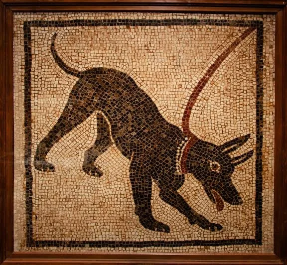
Pet-keeping in Antiquity: Osteological Traces of Companion Animals

October 18, 2026

How animal skeletons can illuminate the relationships between people and animals beyond food production, labor, and economic necessity.

Introduction: Animals as More Than Resources

Animals played indispensable roles in ancient societies. They supplied meat, milk, hides, wool, and transport; protected settlements; controlled pests; and participated in hunting and religious ceremonies. Yet animals were not always valued primarily for what they produced. Some lived alongside humans as companions, occupying domestic spaces and developing relationships that extended beyond practical utility.

Identifying ancient pet-keeping is one of archaeology's more challenging tasks. A dog buried near a house might have been a working animal, a companion, a ritual offering, or a combination of these. A cat's remains might reflect natural mortality, pest control, food consumption, or deliberate burial. Bones alone rarely reveal the emotional character of a relationship.

Osteology—the study of bones and skeletal remains—provides a foundation for investigating these questions. When combined with burial context, pathology, isotopic analysis, genetics, and historical evidence, animal skeletons can help researchers understand how people cared for animals and how those relationships varied across time and place.

Reading Animal Skeletons

The first stage of analysis is species identification. Researchers examine skeletal morphology, comparing the shape and size of bones with reference collections. This can distinguish animals that played different roles in ancient households and settlements.

Age at death is another important variable. Tooth eruption, tooth wear, and the fusion of skeletal growth plates can help estimate an animal's age. An assemblage containing animals of different ages may reflect breeding, food production, working life, or other forms of management. It does not independently establish companion status.

Body size and morphology can also provide clues. Selective breeding may produce distinctive physical characteristics, while unusual skeletal proportions may indicate domestication or specialized use. However, size variation within a species can arise from many causes, including nutrition, environment, genetics, and measurement differences.

Researchers therefore begin with a basic question: what can the bones establish directly? Species, approximate age, body size, and certain forms of injury or disease may be identifiable. Emotional attachment, household role, and the animal's individual relationship with a person require broader contextual interpretation.

Pathology and Evidence of Care

Skeletal pathology can reveal injuries, chronic diseases, and changes associated with aging. Some conditions may have made movement difficult or reduced an animal's ability to obtain food independently. If an animal survived for a considerable period with such a condition, human assistance becomes one possible explanation.

Yet survival does not automatically prove deliberate care. Animals may adapt to injuries, receive help from other animals, or remain capable of finding food despite physical limitations. Researchers need to assess the severity of the condition and whether it would realistically have prevented independent survival.

Healed fractures are particularly informative because they indicate survival after injury. In some cases, their location and severity can help researchers estimate how much the animal's mobility may have been affected. Evidence of prolonged survival, combined with a domestic setting and other signs of human management, can strengthen an argument for care.

Dental disease, abnormal bone growth, and degenerative joint changes may also reveal aspects of an animal's life. These conditions can affect animals used for work just as readily as companions, so they must be interpreted in relation to species, age, activity, and context.

Burials, Memorialization, and Individual Animals

Animal burials can provide some of the strongest evidence that people treated particular animals differently from ordinary food remains. A complete skeleton placed deliberately in a grave, especially when carefully arranged or associated with an individual human burial, may indicate special treatment.

The meaning of that treatment remains open to interpretation. Animals could be buried as companions, ritual offerings, symbols of status, protective figures, or components of funerary practices. A burial alone cannot determine which explanation is correct.

Spatial relationships are crucial. Researchers ask whether the animal was buried separately or with a person, whether the grave was contemporary with nearby human burials, and whether the animal's body was arranged in a deliberate position. They also examine whether the remains show butchery marks or other evidence inconsistent with an intact burial.

Repeated examples can reveal broader cultural patterns. If animals are consistently buried in particular locations or treated in similar ways, researchers may infer that the practice followed established conventions. Even so, the meaning of these conventions may have varied between communities.

Dogs, Cats, and Other Potential Companions

Dogs are especially important in studies of ancient human-animal relationships because they performed many roles. They could assist in hunting, guard settlements, manage livestock, carry loads, or accompany people in daily life. These roles were not necessarily separate: a dog might work and remain a close household companion.

Cats also occupied varied positions in ancient communities. Their relationships with people could be connected to the control of rodents, protection of stored food, religious symbolism, and domestic life. The development of close human-cat relationships was not identical across all regions.

Other animals may have lived near people without fitting modern categories of pets. Birds, monkeys, small mammals, and unusual or exotic animals sometimes appear in ancient artistic and archaeological contexts. Their presence may reflect companionship, display, religious practice, trade, or specialized care.

It is important not to impose a modern distinction between “pet” and “working animal” on societies that may not have used the same categories. The more productive question is how an animal participated in human life and whether the evidence suggests a relationship extending beyond immediate economic utility.

Scientific Methods and Their Limitations

Stable isotope analysis can sometimes help reconstruct an animal's diet and geographical history. Carbon and nitrogen isotopes may reveal dietary patterns, while oxygen and strontium isotopes can contribute to investigations of geographic origin and movement. These results depend on suitable reference data and careful sampling.

Ancient DNA may help establish ancestry, population relationships, and certain aspects of domestication. It cannot, however, identify affection or companionship directly. Genetic similarity between an ancient animal and a modern breed does not demonstrate that the animal was a pet.

Chemical and microscopic analyses can also help distinguish different forms of deposition. For example, traces of burning, butchery, or sediment movement may clarify whether a skeleton was deposited as a body, processed for food, or displaced after burial.

The most persuasive interpretations combine multiple independent forms of evidence. A carefully arranged burial, an unusual history of survival, and a domestic context together provide a stronger case for special treatment than any one of these observations in isolation.

Conclusion: Reconstructing Relationships from Bones

The osteology of ancient animals reveals more than diet and economic production. It can also illuminate how people managed, protected, buried, and potentially formed close relationships with particular animals.

The evidence is rarely simple. A healed injury may suggest care, a burial may suggest special treatment, and a domestic location may indicate proximity to people—but none independently proves companionship. These interpretations become more convincing when skeletal evidence is supported by archaeological context and complementary scientific analysis.

Studying ancient pet-keeping ultimately broadens the history of everyday life. It encourages archaeologists to consider animals not merely as resources or symbols, but as living participants in the social worlds of ancient communities.
Microstratigraphy of Urban Waste: Reconstructing Ancient Shopping Habbits

October 18, 2026

How microscopic layers of discarded material can reveal patterns of consumption, household behavior, and commercial activity in ancient cities.

Introduction: The City Hidden in Its Rubbish

Urban waste is one of archaeology's most valuable sources of evidence about daily life. Discarded pottery, food remains, charcoal, broken tools, and construction debris reveal how people consumed goods, prepared meals, repaired possessions, and maintained their surroundings.

The study becomes even more revealing when researchers examine waste at a microscopic scale. Microstratigraphy investigates the thin layers and small-scale structures that develop within deposits. Instead of treating rubbish as one undifferentiated mass, researchers examine how it accumulated, whether different materials were deposited together, and whether later activities disturbed the original sequence.

These details can help reconstruct shopping habits, although waste does not record purchasing directly. A broken ceramic vessel may have been bought locally or acquired through inheritance, reuse, or exchange. Food remains may reflect market purchases, household production, gifts, or supplies brought from rural relatives.

Microstratigraphy is therefore best understood as a way to investigate consumption through its material consequences rather than as a direct record of transactions.

How Urban Waste Accumulated

Ancient cities generated waste through many overlapping activities. Households discarded food scraps and broken utensils, craftspeople produced manufacturing debris, merchants removed damaged packaging, and public authorities organized cleaning and disposal in different ways.

Waste could accumulate in courtyards, streets, drains, pits, abandoned buildings, and designated dumping areas. Some deposits formed gradually through repeated disposal, while others resulted from a single event such as the demolition of a building or the filling of a disused feature.

These different formation processes matter because they influence what an assemblage can tell us. A household rubbish pit may contain a mixture of food remains, pottery, and ash from repeated domestic activities. A street deposit may combine material from multiple households and businesses. A drain may selectively preserve small objects and organic residues washed into it.

Before interpreting consumption patterns, archaeologists must reconstruct how the deposit formed. Otherwise, material from different activities or periods may be incorrectly treated as evidence of a single shopping event or household behavior.

Reading Deposits Layer by Layer

Microstratigraphic analysis begins with careful recording of the sediment sequence. Researchers document changes in color, texture, composition, and the presence of small inclusions such as charcoal, ash, bone fragments, or plant material.

Intact sediment blocks can be removed and prepared as thin sections for microscopic examination. Under a microscope, researchers may identify compacted layers, trampled surfaces, ash deposits, organic residues, and evidence of water movement. These patterns help distinguish between deliberate dumping, gradual accumulation, and later disturbance.

A thin layer rich in charcoal might represent a brief burning episode, but it could also contain redeposited material from a nearby hearth. A concentration of food remains might indicate preparation or consumption, yet it could have been moved from another location. The physical relationships between components help determine which explanation is most plausible.

Microscopic evidence becomes particularly powerful when it can be linked to identifiable objects. For example, a sequence containing pottery fragments, animal bones, and plant remains may help reconstruct repeated domestic disposal. The interpretation becomes stronger when artifact refitting, species identification, and chemical analysis support the same pattern.

What Waste Reveals About Shopping Habits

Shopping habits are difficult to observe directly in the archaeological record. Researchers instead examine indirect indicators of consumption, including the types of goods represented, their condition, their geographic origins, and their distribution across households or neighborhoods.

Imported pottery may suggest access to long-distance trade, but it does not prove that the owner purchased it from a merchant. Containers might have arrived with imported food or drink, been exchanged as gifts, or been acquired secondhand.

The diversity of ceramic forms can provide information about dining and storage practices. Changes in vessel types may indicate shifts in cooking, serving, or consumption. When these changes occur across multiple households, they may reflect wider transformations in markets, trade networks, or social preferences.

Food remains provide another perspective. Differences in animal species, fish consumption, plant foods, and food preparation may reveal variation in access to resources. However, diet is influenced by ecology, occupation, household size, cultural practice, and preservation conditions as well as purchasing power.

The strongest shopping-related interpretations emerge when waste patterns are compared with market locations, transport infrastructure, workshop areas, and historical evidence of trade or regulation.

Inequality Between Urban Households

One of the most important questions is whether different social groups had different access to goods. Archaeologists may compare household deposits across neighborhoods, examining the frequency of imported items, the diversity of food remains, the quality of tableware, and evidence of repair or reuse.

Such comparisons require caution. A household with few imported ceramics may have used wooden or metal containers that survive poorly. A rich deposit might reflect a large family, a commercial establishment, or a specialized activity rather than greater wealth.

Researchers should also consider the lifespan of objects. Expensive goods may have been retained and repaired for generations, while inexpensive items could be discarded quickly. The quantity of discarded material therefore does not translate directly into the quantity purchased.

Even with these limitations, consistent differences across several forms of evidence can reveal unequal access to goods and resources. Microstratigraphy adds another dimension by showing whether these differences developed gradually or appeared during particular periods of urban change.

Reuse, Repair, and the Limits of Consumption Evidence

Discarded objects do not always represent the end of an object's useful life. Broken pottery might be reused as a lid, building material, or packing fragment. Metal could be melted down, while textiles and leather might be repaired or repurposed before final disposal.

This means that waste reflects both consumption and decisions about extending the life of possessions. A large quantity of broken material may indicate intensive use, demolition, or the clearing of accumulated debris rather than unusually high consumption.

Researchers examine wear patterns, repairs, residues, and the size of fragments to investigate these possibilities. Refitting pieces of the same vessel can reveal whether fragments were discarded together or spread across different deposits.

Microstratigraphy can help establish whether objects entered the deposit during one event or accumulated through repeated episodes. This temporal resolution is essential for reconstructing changes in everyday behavior.

Conclusion: A Microscopic History of Urban Life

Microstratigraphy turns urban waste into a detailed record of how cities functioned. Thin layers of sediment can preserve traces of cleaning, cooking, disposal, manufacturing, and the repeated handling of everyday goods.

These deposits do not provide a literal shopping ledger. Purchasing, inheritance, exchange, reuse, and household production can produce overlapping archaeological signatures. Nevertheless, the combined study of sediment, artifacts, food remains, and urban geography can reveal patterns of consumption and inequality.

By looking closely at what people discarded, archaeologists can recover parts of urban life that monumental buildings and elite documents often overlook. The rubbish of an ancient city becomes evidence not simply of what people owned, but of how they used, repaired, shared, and eventually abandoned the material objects around them.

The Role of Wild Tubers in Late Pleistocene Diets: Starch Grain Evidence

October 18, 2026

How microscopic traces of plant starch are helping researchers investigate the foods consumed by ancient hunter-gatherers.

Introduction: Looking Beyond Bones and Stone Tools

For much of archaeological history, reconstructions of prehistoric diets relied heavily on animal bones, charred seeds, and recognizable plant remains. These materials have provided essential information about hunting, gathering, and the development of agriculture. However, they represent only part of the foods that people consumed.

Many edible plants leave little visible evidence. Soft tissues decay, tubers disintegrate, and plant material may disappear unless it is charred or preserved under unusual conditions. As a result, archaeological deposits can underrepresent the importance of roots and underground storage organs in ancient diets.

Starch grain analysis offers a way to investigate this hidden food history. Starch grains are microscopic structures produced by plants to store energy. They may survive on stone tools, in sediment, or within other protected archaeological contexts, providing clues about the processing of plant foods.

For the Late Pleistocene, a period extending from approximately 129,000 to 11,700 years ago, this evidence is especially valuable. It allows researchers to explore how ancient populations used wild plants long before farming became widespread.

What Are Starch Grains?

Plants store energy in starch, a carbohydrate composed of glucose molecules. In many plant tissues, starch occurs as microscopic granules within cells. Their shapes, sizes, surface features, and internal structures can vary among plant groups.

Under appropriate preservation conditions, these granules can survive long after the surrounding plant tissue has decayed. Researchers recover them from archaeological materials and compare their characteristics with starch reference collections made from modern plants.

Different plants may produce granules with distinctive features, but identification is rarely straightforward. Closely related species can have similar starch morphology, and processing can alter the appearance of granules. Grinding, heating, fermentation, and other activities may damage or transform the structures.

Consequently, researchers should avoid identifying an archaeological starch grain as a particular species when the evidence supports only a broader plant family or group. Reliable identification depends on comparative analysis and a clear understanding of the method's limitations.

Tubers as Prehistoric Foods

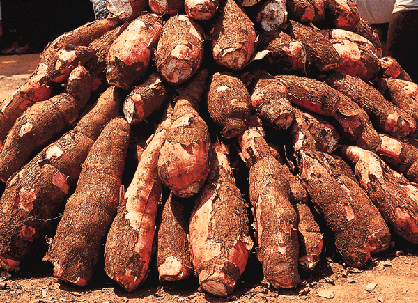
Tubers and other underground storage organs can be valuable food sources. They often contain carbohydrates, and some can remain available when above-ground vegetation is limited. Their nutritional value and seasonal availability vary considerably by species and environment.

Wild tubers can also require substantial work before consumption. Some are fibrous, tough, bitter, or chemically defended, making digging, peeling, pounding, cooking, or soaking necessary. Archaeological evidence of grinding and heating may therefore help reconstruct the techniques used to make plant foods edible.

The presence of starch residues on a tool can suggest that plant material was processed with it. Yet it does not necessarily establish whether the tool was used to dig up tubers, crush them, prepare them for cooking, or process another starchy resource.

Researchers must distinguish tubers from other potential starch sources, including seeds, rhizomes, fruits, and underground stems. The term “tuber” refers to a particular plant structure, and not every edible underground plant part is botanically a tuber.

Recovering Starch from Archaeological Tools

Stone tools can preserve microscopic residues in surface depressions, cracks, and areas protected from abrasion. Researchers collect samples using procedures designed to reduce contamination, then examine them under a microscope.

Grinding stones and tools with heavily used surfaces may be particularly informative. If starch grains occur in locations consistent with use-related wear, and their identification matches the proposed plant-processing activity, they can provide evidence of prehistoric food preparation.

However, starch can also enter a tool's surface after deposition. Soil, plant roots, handling, conservation materials, and modern laboratory environments can introduce contaminants. Researchers therefore use control samples, document the sampling process, and compare residue distributions with the tool's archaeological context.

Use-wear analysis can provide independent support. Microscopic scratches, polish, and edge damage may indicate how a tool was used, although different activities can produce overlapping patterns. Combining residue and wear evidence is more reliable than interpreting either alone.

Reconstructing Late Pleistocene Diets

Starch evidence can help expand the known range of foods consumed by prehistoric populations. In some archaeological contexts, residues on stone tools have been interpreted as evidence for the processing of starchy plants before the emergence of agriculture.

Such findings are important because they challenge the assumption that early hunter-gatherers relied predominantly on meat or that intensive plant processing began only with farming. Human diets varied widely according to local environments, technology, and cultural knowledge.

Nevertheless, the presence of starch grains does not establish how frequently a plant was eaten or what proportion of calories it supplied. A few residues might reflect occasional processing, while an absence of starch does not prove that a plant was never consumed.

Researchers must also consider the preservation conditions of each site. A location that preserves starch grains well may appear to have a more plant-rich diet than a site where similar residues were destroyed. Comparisons between sites therefore require attention to sampling and preservation differences.

Connecting Plant Processing to Technology and Social Life

The processing of wild tubers could have influenced the tools, mobility, and daily routines of prehistoric groups. Gathering underground plant foods requires knowledge of where plants grow, when they are available, and how they can be processed safely.

Such knowledge may be passed between generations and adapted to changing environments. The archaeological record rarely preserves the teaching process directly, but repeated patterns of tool use and plant exploitation can reveal the persistence of particular technical traditions.

Plant foods may also have contributed to dietary flexibility. A community that could obtain both animal and plant resources would have more options when particular foods became scarce. The importance of any specific tuber, however, would depend on its abundance, nutritional value, accessibility, and the work required to prepare it.

To reconstruct these relationships, archaeologists combine starch analysis with botanical remains, animal bones, tool studies, environmental reconstruction, and evidence of ancient human movement.

Conclusion: Recovering the Invisible Ingredients of Prehistory

Starch grain evidence provides a powerful method for investigating plant foods that rarely survive in recognizable form. It can help researchers identify previously overlooked aspects of Late Pleistocene diets and explore the technological knowledge required to process wild plants.

The method is not without limitations. Contamination, ambiguous identification, and uncertain relationships between residue and activity can complicate interpretations. Most importantly, microscopic evidence of a plant's presence does not automatically reveal its dietary importance.

When carefully integrated with other archaeological evidence, starch analysis contributes to a broader understanding of human adaptability. It shows why prehistoric diets should not be reconstructed solely from the most visible remains, and why the smallest traces can sometimes reveal a substantial part of ancient life.

Ancient Weather Stations? Correlating Tree-Ring Data with Coastal Sites

October 18, 2026

Using tree rings and coastal archaeological evidence to reconstruct past environmental conditions without assuming that ancient communities operated formal weather-monitoring systems.

Introduction: Can Trees Reveal the Weather of the Past?

Weather has always influenced human activity. Storms affect navigation, rainfall influences harvests, and temperature shapes the availability of food and building materials. Yet systematic instrumental weather records extend back only a relatively short period compared with human history.

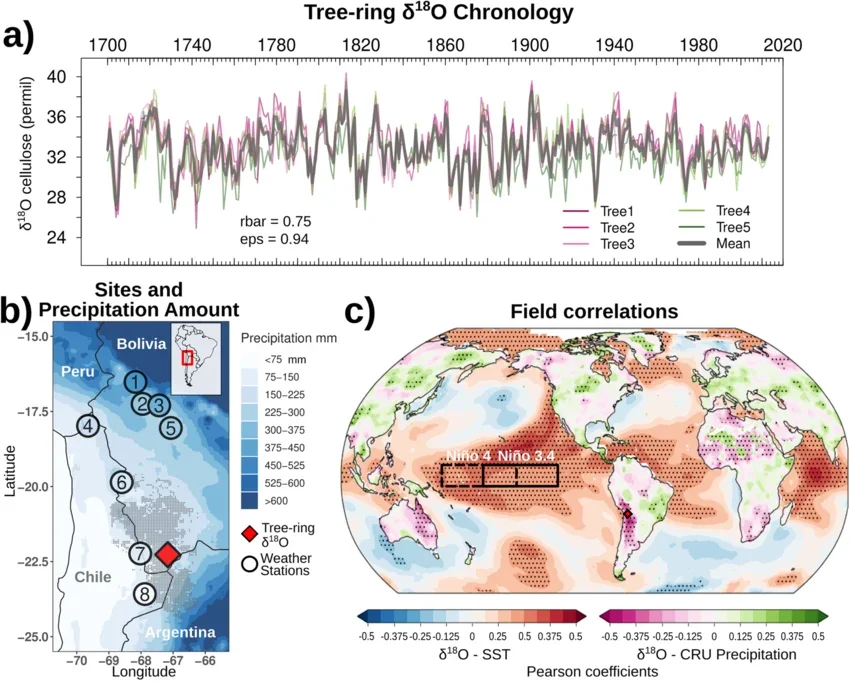
Archaeologists and environmental scientists therefore use natural archives to reconstruct earlier conditions. Tree rings are among the most valuable of these archives because many trees produce annual growth layers whose width, density, and chemical characteristics respond to environmental conditions.

When tree-ring records are compared with archaeological evidence from coastal settlements, researchers can investigate how environmental variability affected maritime communities. Changes in timber supply, harbor maintenance, settlement activity, and patterns of damage may sometimes be examined alongside reconstructed droughts, cold periods, or storms.

The phrase “ancient weather stations,” however, is potentially misleading. Tree-ring records do not demonstrate that ancient people operated formal meteorological stations. Instead, the research concerns the reconstruction of past weather and climate through natural evidence and the investigation of how people responded to it.

The Science of Tree-Ring Dating

Dendrochronology is the study of annual tree rings, especially for establishing the dates of wooden materials. In suitable species and environments, trees form recognizable growth rings each year. Variations in ring width and other properties can reflect changing environmental conditions.

By comparing ring sequences from different trees, researchers construct chronological patterns. A sequence from an archaeological beam may be matched against a regional reference chronology, potentially establishing when the tree was growing and, in favorable circumstances, when it was felled.

The distinction between tree growth and building construction is important. A beam may have been stored, reused, or incorporated into a structure years after the tree was cut. The date of the outermost preserved ring can therefore provide a felling estimate only when the relevant outer wood is present and the sample's history is understood.

Tree rings also provide environmental information. In some regions, growth responds strongly to rainfall; in others, temperature, soil moisture, competition, or other variables may be more influential. A narrow ring does not automatically indicate drought, and the relationship must be calibrated using suitable regional data.

Reconstructing Past Weather and Climate

Tree-ring research can reveal patterns in environmental conditions across decades or centuries. Depending on the species and location, researchers may reconstruct aspects of growing-season temperature, precipitation, drought severity, or other variables.

These reconstructions are not direct measurements of every weather event. A tree's growth integrates several environmental influences, and the signal may be stronger for some conditions than others. Researchers use statistical calibration and comparisons with instrumental records where available to evaluate the reliability of their models.

Climate and weather must also be distinguished. Climate describes longer-term patterns and variability, while weather refers to conditions over shorter periods. Tree rings commonly provide annual or seasonal information rather than a detailed record of individual storms.

Evidence for a specific storm may sometimes be investigated through damaged trees, sediment deposits, coastal erosion, or other geological indicators. Even then, establishing the date and intensity of a particular event can be difficult. Multiple independent records are essential when researchers attempt to connect an environmental episode to an archaeological change.

Coastal Settlements as Environmental Archives

Coastal settlements are particularly sensitive to environmental change because they depend on the relationship between land, sea, and transport. Harbors, landing places, fish-processing areas, and coastal roads can be affected by erosion, sediment accumulation, flooding, and changing shoreline conditions.

Archaeological wood from boats, buildings, harbor structures, and repairs may preserve tree-ring sequences. If the wood can be dated accurately, researchers can establish when timber was harvested and sometimes when construction or repair occurred.

These dates can then be compared with environmental records. For example, a cluster of repairs might coincide with evidence of coastal instability, but coincidence alone cannot establish that a storm or climate shift caused the work. Repairs may also reflect routine maintenance, economic growth, warfare, or changes in harbor use.

Sediment cores from nearby wetlands, estuaries, and lagoons can provide additional evidence. Changes in grain size, salinity, microfossils, and sediment composition may reveal shifts in coastal conditions. Such records can help determine whether a harbor became shallower, a shoreline migrated, or a waterway changed course.

Testing the Relationship Between Environment and Human Activity

A rigorous study begins by establishing independent chronologies for the tree-ring records and archaeological features. Researchers then compare their timelines and investigate whether the proposed environmental relationship is plausible.

The next step is to consider alternative explanations. If a coastal settlement declined during a period of environmental stress, researchers should also examine trade changes, political disruption, population movement, conflict, and shifts in local resources.

The spatial distribution of evidence matters as well. A regional drought may have affected inland agriculture differently from coastal fishing, while a storm could damage one harbor but leave another relatively protected. Local topography and settlement design can influence the severity of environmental effects.

Researchers can also compare several coastal sites rather than relying on one example. If independently dated settlements show similar responses to a well-supported environmental event, the argument for a broader relationship becomes stronger.

Were Ancient Communities Their Own Weather Forecasters?

People who lived close to the sea developed practical knowledge of winds, tides, seasonal patterns, cloud formations, and the behavior of local waters. Such knowledge could be essential for fishing, navigation, agriculture, and travel.

However, this expertise should not be confused with a formal weather station. An ancient community might have recognized seasonal warning signs or developed reliable rules of thumb without recording meteorological measurements in the modern scientific sense.

Archaeologists can investigate environmental knowledge indirectly through maritime technology, seasonal settlement patterns, written observations where available, and evidence of adaptation to recurring hazards. These sources may reveal how communities responded to their surroundings, but they do not necessarily document a standardized forecasting system.

The more defensible interpretation is that ancient people observed and responded to environmental patterns, while modern researchers use natural archives to reconstruct the conditions under which those decisions were made.

Conclusion: Reading Coastal History Through Living Archives

Tree-ring records and coastal archaeological sites can be powerful partners in reconstructing the environmental context of ancient life. Tree rings provide chronological and climatic information, while archaeological structures and sediment deposits reveal how coastal communities used and modified their surroundings.

Their correlation can identify possible relationships between environmental change and human activity, but it cannot establish causation without additional evidence. Tree-ring signals vary by region, archaeological dates have limitations, and coastal settlements change for many reasons.

The real achievement of this research is not the discovery of literal ancient weather stations. It is the creation of a more detailed history of human-environment relationships, one that combines natural archives with material evidence to explore how communities navigated a changing world.

The Forensic Archaeology of Shipworm Damage on Maritime Heritage

October 18, 2026

How biological traces in submerged wood can help researchers reconstruct the deterioration, exposure, and preservation of historic ships and coastal structures.

Introduction: When the Sea Becomes an Archaeological Agent

Wooden ships, harbor structures, piers, and submerged buildings can preserve extraordinary evidence of maritime history. They may reveal shipbuilding techniques, commercial connections, construction materials, and the practical knowledge required to operate in coastal environments.

Yet the underwater environment is rarely passive. Marine organisms colonize submerged materials, sediment shifts around structures, and changes in salinity, oxygen, temperature, and water movement influence how wood survives. Among the organisms capable of damaging maritime timber are shipworms, marine bivalves that bore into wood.

Despite their common name, shipworms are not worms in the strict zoological sense. They are specialized mollusks that use wood as a habitat and food source, with microorganisms helping them digest its cellulose. Their activity can create tunnels and cavities inside timber, weakening structures while sometimes leaving distinctive patterns.

Studying this damage can contribute to maritime archaeology, but it requires careful identification. Not every hole in submerged wood was made by shipworms, and damage alone rarely reveals exactly when or where an organism attacked the timber.

Understanding Shipworms and Their Effects

Shipworms belong to the bivalve family Teredinidae. Unlike many familiar shellfish, they have elongated bodies adapted to life inside wood. Their small shell structures function in boring, allowing them to excavate tunnels as they grow.

The resulting damage can be extensive. A wooden plank may appear relatively intact on the outside while containing a network of internal galleries. Over time, this can reduce the timber's structural strength and contribute to the collapse of vessels or coastal installations.

The severity of damage depends on several factors, including the species involved, the duration of exposure, water conditions, and the characteristics of the wood. Not every coastal environment supports the same shipworm species or levels of activity.

These differences matter when interpreting archaeological remains. A heavily bored timber may have spent time in biologically favorable waters, but the damage cannot automatically identify a particular harbor or route. Environmental reconstruction and additional evidence are needed to narrow the possibilities.

Identifying Biological Damage in Archaeological Wood

The investigation begins with detailed recording of the wood's external and internal condition. Researchers document holes, galleries, fractures, missing surfaces, and the relationship between biological damage and other forms of deterioration.

Three-dimensional imaging, radiography, and computed tomography can help reveal internal tunnel systems without immediately cutting the specimen apart. Where destructive sampling is justified, cross-sections can provide more detailed information about the relationship between galleries and wood anatomy.

Microscopic analysis may help distinguish shipworm damage from the activity of other marine borers, fungi, and physical processes. Some organisms produce characteristic tunnel forms or leave shell fragments and other traces, but identification depends on preservation and comparison with appropriate reference material.

Researchers also need to consider damage that occurred after recovery. Archaeological wood may shrink, crack, or become distorted as it dries. Conservation treatments can alter its appearance, and modern handling may create additional marks. A forensic assessment must separate ancient biological damage from later deterioration wherever possible.

Reconstructing the History of a Shipwreck

Shipworm damage can contribute to the reconstruction of a vessel's history before and after its final deposition. Timber may have been exposed to seawater during the ship's working life, while other damage may have developed after the vessel sank.

The distinction is not always easy to establish. A ship that operated in warm coastal waters might have suffered biological attack before sinking. Alternatively, a vessel entering a new environment could have encountered different marine organisms during its final voyage or while lying submerged.

Researchers therefore examine where the damage occurs. Boring in external planking, internal structural timbers, replacement components, and sheltered surfaces may reflect different exposure histories. The patterns must be interpreted in relation to the vessel's construction and the conditions in which it was found.

Shipworm damage can also complicate the interpretation of a wreck's original form. Missing wood and weakened joints may cause timbers to collapse or separate after sinking. Archaeologists must account for these processes before reconstructing the vessel's dimensions, orientation, and structural arrangement.

Environmental Reconstruction and Maritime Movement

Marine biological communities vary across geographic regions and environmental conditions. If researchers can identify the organisms responsible for damage, they may gain clues about the environments in which a timber was exposed.

This possibility must be approached cautiously. Shipworms can be transported through maritime networks, and their geographic distributions may change over time. A species found on a shipwreck does not necessarily prove that the vessel sank where the organism was collected.

Environmental indicators can strengthen the interpretation. Sediment characteristics, salinity-related evidence, other marine organisms, and the archaeological history of the wreck may help establish whether the site experienced conditions suitable for the observed damage.

The wider significance lies in understanding how biological processes interacted with human mobility. Ships transported goods and people, but their wooden structures also entered ecological environments that could affect their durability and performance.

Conservation of Waterlogged Maritime Heritage

Waterlogged wood can remain preserved for long periods because waterlogged conditions may limit some forms of decay. However, once exposed to air, archaeological timber can deteriorate rapidly if it dries without appropriate treatment.

Shipworm damage creates additional conservation challenges because the wood may contain extensive internal cavities and weakened structural connections. A specimen that looks stable externally may be fragile throughout its interior.

Conservation planning begins with documentation and assessment. Researchers evaluate the object's dimensions, degree of damage, waterlogged condition, and the importance of preserving its original structure. Stabilization methods depend on the wood's condition and the resources available to the conservation team.

Not every object needs to be removed from the water. In some cases, leaving a wreck in place may be preferable, particularly when excavation would cause substantial deterioration or when the site can be monitored and protected effectively.

The choice between in-situ preservation and recovery must consider archaeological value, environmental conditions, legal requirements, and the long-term capacity to conserve the material.

Conclusion: Reading Biological Damage as Historical Evidence

Shipworm damage is more than a destructive process. When carefully documented, it can provide information about the environmental exposure and preservation history of maritime timber.

The evidence is rarely sufficient to reconstruct a vessel's route or final voyage by itself. Biological identification, wood anatomy, environmental analysis, and the archaeological context must be considered together.

This forensic approach helps researchers understand maritime heritage as the product of both human construction and natural processes. The surviving remains of a wooden ship record not only the decisions of builders and sailors, but also the ecological conditions that shaped the vessel's life beneath the waves.

Cryptic Rock Alignments: Seasonal Calendars of Pastoralists in Asia

October 18, 2026

Investigating whether arrangements of stones in pastoral landscapes reflect seasonal observation, practical navigation, ceremonial activity, or other forms of environmental knowledge.

Introduction: Reading Time into the Landscape

Pastoral communities have long organized their activities around seasonal changes. The availability of grass, water, and shelter influences when animals move between grazing grounds, while temperature and precipitation shape the timing of breeding, migration, and other aspects of herd management.

In parts of Asia, landscapes used for pastoralism contain standing stones, stone rows, cairns, and other arrangements whose purposes may not be immediately clear. Some have been interpreted as markers of routes or territories; others have attracted suggestions that they helped people track the seasons or observe celestial movements.

These possibilities are intriguing, but a stone alignment does not become a calendar simply because it points toward a mountain peak or the horizon. Natural terrain, construction convenience, and later disturbance can produce alignments that appear meaningful from particular viewpoints.

To establish a seasonal function, researchers need evidence that the arrangement was deliberately designed or used to mark recurring temporal events. Archaeology can investigate this possibility through surveying, dating, landscape analysis, and comparison with the practical requirements of pastoral life.

Pastoral Landscapes and Seasonal Mobility

Pastoralism involves the management of domesticated animals that depend on available vegetation and water. In many environments, herders move animals between different grazing areas to take advantage of seasonal resources and reduce pressure on any one location.

The timing and route of these movements vary by region. High-altitude pastures may be usable only during warmer months, while lower elevations provide winter grazing. In arid areas, access to water may be the primary factor governing movement.

Stone markers could serve practical functions within such landscapes. They might identify routes, indicate boundaries, mark gathering places, or provide recognizable reference points in areas where vegetation changes seasonally.

However, pastoral systems are diverse, and the presence of stones near a grazing route does not establish that herders constructed them. Researchers must first determine whether the features are human-made, whether they are contemporary with pastoral use, and whether their distribution corresponds to known movement patterns.

How Stone Alignments Are Surveyed

A rigorous investigation begins with precise recording of the stones' positions, dimensions, orientations, and relationships to the surrounding terrain. Researchers may use total stations, satellite positioning, aerial photography, and three-dimensional modeling to document the arrangement.

The surrounding landscape must be analyzed as well. Investigators examine slopes, ridgelines, water sources, visibility, and possible travel routes. These factors can reveal whether an alignment is positioned in a way that would be useful for navigation or seasonal movement.

A key methodological challenge is distinguishing intentional alignment from coincidence. In a landscape containing many stones and possible viewing directions, some will inevitably align with peaks, sunrise positions, or distant landmarks by chance.

Researchers can address this problem by comparing the observed arrangement with plausible alternatives. Statistical and spatial models may estimate whether the alignment is more structured than would be expected under a random arrangement, although the results depend on assumptions about how stones could have been placed.

The analysis should be conducted before selecting the most appealing interpretation. Otherwise, investigators risk choosing a celestial or seasonal target after inspecting many possible alignments.

Testing the Seasonal Calendar Hypothesis

If an alignment is proposed as a seasonal marker, researchers must define what event it may have indicated. Possible targets include solstices, equinoxes, the appearance of a particular star, a seasonal sunrise, or a recurring environmental feature.

The next step is to reconstruct the relevant horizon as it existed during the period of construction. Atmospheric conditions, terrain changes, vegetation, and the movement of celestial bodies over long periods may affect the accuracy of modern observations.

Chronology is essential. An alignment that corresponds with a modern sunrise may not have pointed toward the same position at the time it was built. Researchers need a defensible date range before claiming a precise astronomical relationship.

Even a convincing alignment does not prove that people used it as a calendar. The direction may have had symbolic meaning, served as a route marker, or resulted from other design considerations. Independent evidence of repeated seasonal activity would strengthen the interpretation.

Environmental Knowledge Without Formal Astronomy

Pastoral communities can develop detailed environmental knowledge through observation and experience. Changes in vegetation, animal behavior, snow cover, water availability, and weather may signal the best time to move between grazing areas.

Such knowledge does not require stone monuments or formal astronomical systems. It may be transmitted through practice, oral instruction, and shared experience.

Archaeology can investigate the relationship between environmental knowledge and material features, but the absence of written records creates limits. A stone arrangement may have been part of a system of practical reference points without functioning as a calendar in the modern sense.

Researchers should therefore avoid assuming that an ancient community possessed either a formal astronomical science or an entirely informal system. The evidence may support a range of possibilities, and different communities could have combined environmental observation, inherited traditions, and celestial knowledge in distinct ways.

Cultural Meaning and the Danger of Overinterpretation

Stone alignments often attract speculative explanations because they are visually striking and can be difficult to date. Claims that they encode advanced astronomy or secret knowledge may circulate without adequate archaeological support.

A disciplined approach begins with the physical evidence and considers several hypotheses. Could the stones mark a route? Were they associated with burial or ceremonial activity? Do they define a boundary or gathering area? Is there evidence that they were modified over time?

The answers may remain uncertain, and that uncertainty is part of responsible archaeological interpretation. A site can be important even when its original purpose cannot be established.

Regional comparison is useful, but only when the sites being compared share relevant characteristics. Similar-looking arrangements in different parts of Asia may have been created by unrelated communities for entirely different reasons.

Conclusion: Timekeeping in a Living Landscape

Rock alignments in Asian pastoral landscapes provide an opportunity to investigate the relationship between movement, environmental knowledge, and monumental features. They may have helped people navigate terrain, mark routes, identify places, or organize activities around recurring seasonal conditions.

The claim that a particular alignment functioned as a seasonal calendar requires more than geometric resemblance. It needs secure chronology, careful spatial analysis, and evidence that the proposed function fits the broader archaeological context.

Whether or not a calendar interpretation is confirmed, the study of these features can reveal how people organized their relationship with the landscape. It also reminds researchers that seasonal knowledge is not always preserved in written documents or elaborate monuments; it can be embedded in routes, landmarks, and repeated patterns of movement across the land.

The Archaeology of Salt Curing: Fish, Meat and Long-Distance Trade

October 18, 2026

How preserved foods connected ancient communities, supported maritime travel, and helped transform perishable resources into valuable commodities.

Introduction: Preserving Food Beyond Its Place of Origin

Before refrigeration, the movement of perishable food across long distances depended on methods that slowed spoilage. Salting, drying, smoking, and fermentation helped communities preserve fish and meat so that these products could be stored, transported, and consumed beyond the places where they were obtained.

Salt curing was especially important in many environments because salt could reduce the availability of water needed by microorganisms responsible for spoilage. Its effectiveness depended on the concentration of salt, the characteristics of the food, temperature, moisture, and the processing method. Salt curing did not guarantee that food would remain safe indefinitely, but it could substantially extend its usable life.

The archaeological study of salt curing explores how communities organized this preservation work. Processing installations, salt-production sites, animal remains, containers, and historical documents can reveal the relationship between food preservation and commerce.

However, identifying a site as a salt-curing facility requires more than finding salt nearby. Salt had many uses, and basins or pits could serve different purposes. Researchers must establish how the features functioned and whether they were connected to the preparation of food.

Salt as a Strategic Resource

Salt occurs naturally in seawater, salt lakes, underground deposits, and saline springs. Communities obtained it through different methods, including evaporation, mining, and the processing of naturally concentrated brines.

Its availability was geographically uneven. Some settlements could produce salt locally, while others depended on imports. This created opportunities for trade and sometimes made salt an important resource for regional economies.

The relationship between salt production and food preservation varied by location. Coastal communities might have access to both fish and seawater, but producing enough salt for large-scale curing still required labor, fuel or favorable evaporation conditions, suitable equipment, and organization.

Inland communities could obtain salt through trade or exploit local geological sources. The costs of transporting salt influenced which products could be preserved economically and how far they could travel.

Archaeologists investigate these systems by mapping production sites, examining the distribution of salt-related installations, and studying transport routes. The presence of a salt source near a settlement does not prove that it supplied a particular market, so evidence of chronology and exchange is essential.

Archaeological Evidence of Curing

Salt-curing activities may leave several kinds of traces. These can include processing basins, storage areas, drainage systems, heating installations, and deposits associated with food preparation. Their appearance varies according to the technology used and the materials available.

Chemical analysis can identify elevated salt concentrations or characteristic residues, but interpretation is complicated by natural salinity and later contamination. Researchers compare samples from the suspected installation with nearby soils and geological sources to establish whether the pattern is unusual.

Animal remains can provide complementary evidence. Fish bones, cut marks, species composition, and the representation of different body parts may help distinguish local consumption from specialized processing. For example, a concentration of selected fish parts might suggest preparation for transport, but natural decomposition, waste disposal, and other processing activities can produce overlapping patterns.

Container evidence is also important. Ceramic vessels, amphorae, baskets, and other packaging materials may indicate how food was stored or transported. Residue analysis can sometimes identify the former contents, although chemical traces rarely provide a complete account of the processing sequence.

The strongest interpretation comes from combining these independent forms of evidence rather than relying on one feature or residue.

Fish Curing and Maritime Commerce

Fish is highly perishable, particularly in warm conditions. Salting and drying can transform a seasonal catch into a product that remains useful for longer periods and can be transported away from the coast.

Large-scale fish processing may have supported fishing communities, port cities, military provisioning, and commercial distribution. Preserved fish could be consumed inland or carried aboard ships, providing a source of protein during journeys.

Archaeologists investigate this commerce by examining processing facilities, fish remains, containers, and the distribution of relevant products. Historical documents, where available, may describe fish sales, taxation, production regulations, or the supply of ships and institutions.

It is important not to assume that every fish-processing site produced goods for export. A facility might supply nearby households or a local market. Evidence for long-distance trade becomes stronger when processing remains are linked to transport infrastructure, specialized packaging, and finds in distant settlements.

Meat Preservation and Rural-Urban Exchange

Salt curing also allowed meat to move beyond the immediate area where animals were raised or slaughtered. Livestock could be processed near production centers, after which preserved products traveled to urban markets, military establishments, or other consumers.

Different animals and cuts required different handling practices. Archaeological analysis of butchery marks, skeletal representation, and processing waste can help identify how carcasses were divided and which parts were transported.

A deposit containing many similar body parts may reflect specialized processing, but researchers must also consider the possibility of natural accumulation, disposal patterns, or the activities of a particular household or workshop.

Salt-curing installations may have operated as part of a larger production chain involving livestock raising, slaughter, preparation, storage, and distribution. Reconstructing this chain requires evidence from multiple sites rather than assuming that all stages occurred in one location.

The economic significance of preserved meat depended on demand, transport costs, available salt, labor, and the ability to maintain product quality. These factors varied considerably across regions and periods.

Trade Networks, Markets, and Social Organization

Preserved foods could connect rural producers to urban consumers and coastal settlements to inland communities. Their production required coordination between people who obtained raw materials, those who processed them, and those who transported and sold the finished goods.

Archaeological evidence can reveal different levels of organization. Small processing features associated with households may indicate local production, while extensive installations and standardized containers may suggest more specialized activity.

Even large facilities require careful interpretation. They may have supplied a local population rather than participated in a broad export economy. Production scale, chronology, distribution patterns, and transport infrastructure must be considered together.

Salt-curing industries could also create economic dependencies. Communities without local salt sources might rely on trading partners, while settlements controlling productive saltworks could benefit from their location. However, claims about political control or monopolies require specific historical and archaeological evidence.

Preservation, Diet, and Food Security

Preserved foods helped communities manage seasonal shortages and transport supplies over long distances. They could support sailors, travelers, workers, and populations living far from fresh food sources.

The archaeological record may reveal changes in preservation practices through time. Shifts in fish species, animal remains, processing installations, or container types may indicate changing markets, technological adaptations, or environmental conditions.

Yet the evidence must be evaluated in light of preservation bias. Fish bones may disappear in acidic soils, while organic packaging rarely survives. A site with limited preserved remains may have supported substantial food processing that is archaeologically difficult to detect.

Dietary interpretations should likewise account for social differences. Preserved food might have been an everyday staple for some people and an occasional commodity for others. Access depended on income, location, cultural preference, and the structure of local trade.

Conclusion: Turning Perishable Food into Durable Commerce

The archaeology of salt curing reveals how communities transformed short-lived biological resources into products that could support storage, exchange, and long-distance movement.

Processing installations, animal remains, chemical residues, and transport containers can help reconstruct these systems, but no single indicator proves that a site served a commercial export industry. Reliable conclusions depend on chronology, context, and comparison across production and consumption sites.

Salt curing is therefore more than a preservation technique. It represents a relationship between environmental resources, technical knowledge, labor, and trade—one that helped ancient communities connect food-producing landscapes with distant markets and maritime routes.

Submerged Neolithic Platforms in Northern Europe: Causeways to the Sea

October 18, 2026

Investigating submerged stone and timber structures in landscapes transformed by rising seas, and asking whether they served as pathways, working platforms, or places of gathering.

Introduction: Archaeology Beneath the Modern Shoreline

Northern Europe's coastlines have changed dramatically since the Neolithic period. After the last glacial period, melting ice sheets and changing ocean levels reshaped bays, estuaries, wetlands, and coastal plains. In some regions, land also rose as the Earth's crust responded to the removal of glacial ice.

As a result, places that were once dry land or shallow wetlands may now lie beneath the sea. Archaeologists investigating these submerged landscapes encounter evidence of settlement, fishing, hunting, transport, and other activities that are difficult to reconstruct from modern coastlines alone.

Among the features that attract attention are stone alignments, timber structures, platforms, and causeway-like formations. Some may represent deliberate construction, while others could result from natural processes or later disturbance.

The title's idea of “causeways to the sea” is therefore a useful hypothesis, not a universal explanation for submerged platforms. Establishing the function of a particular structure requires evidence of human construction, secure dating, and a convincing relationship between its form and the surrounding landscape.

Reconstructing the Neolithic Coastline

The first task is to understand the landscape as it existed when the structure was built. Modern sea level is not a reliable guide to the position of the ancient shoreline.

Researchers reconstruct former coastlines using geological cores, sediment analysis, sea-level models, and evidence of glacial and postglacial landscape change. Peat deposits, submerged soils, ancient river channels, and former wetlands can help identify environments that existed before inundation.

Regional differences are important. In parts of northern Europe, relative sea level rose substantially during the early Holocene, while other regions experienced significant land uplift following glaciation. These processes affected the timing and extent of coastal submergence differently.

The date of a structure must therefore be considered alongside local sea-level history. A platform now underwater might have been constructed on dry land, in a tidal zone, or at the edge of a lagoon. Each possibility implies different functions and patterns of use.

Identifying Human-Made Platforms and Causeways

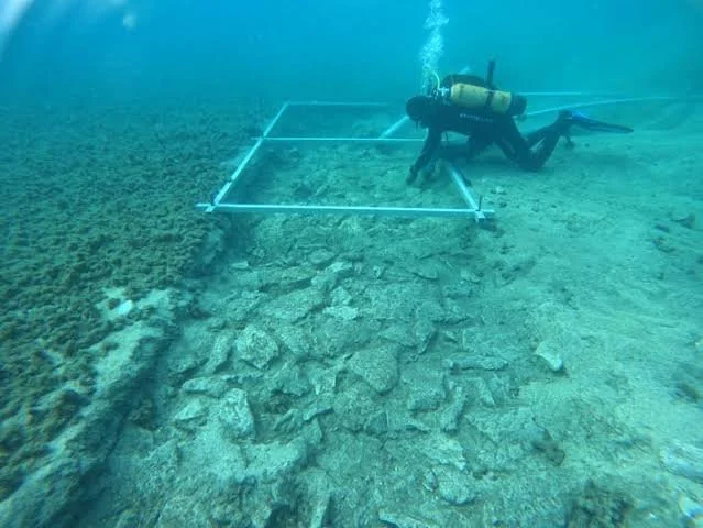
Submerged archaeological structures can be difficult to identify because currents, sediment movement, and marine growth alter their appearance. Stone arrangements may become scattered, while timber can decay or become buried beneath sediment.

Researchers use underwater survey methods such as side-scan sonar, multibeam bathymetry, photogrammetry, and direct diving inspection where conditions permit. These techniques help document shape, elevation, orientation, and relationships with nearby features.

A platform may be indicated by a relatively level surface supported by stones or timber, while a causeway may form a linear route across a wet or shallow area. Yet natural bedrock, glacial deposits, and wave action can create misleading patterns.

Evidence of construction can include repeated structural units, deliberately placed stones, worked timber, joints, or a consistent arrangement that differs from the local geology. Excavation and sediment analysis can clarify whether the feature was built, modified, or naturally formed.

Researchers should also consider whether a structure was created in one phase or developed through repeated additions. A feature that appears uniform in a modern survey may contain several construction episodes separated by substantial periods.

Possible Functions: Access, Fishing, Gathering, and Ritual

A causeway could have provided access across wet ground, tidal flats, or shallow water. A platform might have supported fishing, the handling of boats, the processing of resources, or other activities that benefited from a stable working surface near the water.

The structure's location can help test these possibilities. A feature connecting two areas of former dry land may have served as a route, while a platform near a sheltered inlet might have supported boat-related activities. However, the surrounding landscape must be reconstructed before such relationships can be established.

Some submerged structures have also been interpreted as ceremonial or gathering places. Such an interpretation requires evidence beyond an unusual location. Deposits of selected objects, repeated structured activity, or a meaningful relationship with other archaeological features may support a ritual hypothesis.

These functions are not necessarily mutually exclusive. A route or working platform could also have held social significance. Archaeologists should therefore distinguish the physical use of a structure from the meanings that people may have attached to it.

Dating Submerged Structures

Reliable dating is essential because a structure may have been submerged long after it was constructed. Timber can sometimes be dated using dendrochronology, while suitable organic material may be radiocarbon dated.

However, a dated object found near a structure does not automatically date the structure itself. It might have been deposited before construction, moved by currents, or introduced during later activity.

Researchers therefore seek direct relationships between dated materials and the construction phase. Timber incorporated into a structure may provide stronger evidence than loose wood recovered from nearby sediment, although reuse and preservation conditions must still be considered.

Radiocarbon dates also require careful interpretation. Marine organisms may produce apparent ages affected by the marine reservoir effect, while freshwater and terrestrial samples have different dating considerations. Appropriate calibration and contextual analysis are essential.

Multiple dates from well-documented contexts can help establish whether the platform was constructed, modified, and abandoned during distinct periods.

What Submerged Platforms Reveal About Neolithic Communities

If a structure is confirmed as human-made, it may reveal how Neolithic communities adapted to changing coastal environments. Its construction could indicate knowledge of local materials, water conditions, and the movement of people and resources through wetlands or shallow marine areas.

A platform near a former settlement might have supported subsistence activities or access to coastal resources. A structure in a more exposed location could indicate a different relationship with the sea, although the ancient shoreline and water depth must be reconstructed before drawing conclusions.

Submerged archaeology can also challenge settlement maps based entirely on modern land. Sites now underwater may once have occupied attractive locations near freshwater, fish, shellfish, and transport routes. Their disappearance from the visible landscape can create an incomplete picture of prehistoric settlement patterns.

Preservation is uneven, however. Some materials survive because they were rapidly buried in waterlogged sediment, while others disappear. The distribution of known sites therefore reflects both ancient behavior and the modern conditions under which archaeological remains are preserved and discovered.

Protecting a Fragile Underwater Record

Submerged Neolithic sites face threats from coastal development, dredging, fishing gear, erosion, and changes in marine conditions. Once exposed, timber and other organic remains may deteriorate rapidly.

Archaeologists and heritage authorities must decide whether a site should be excavated, monitored, or left in place. Excavation can provide valuable information, but it also exposes fragile material and creates long-term conservation responsibilities.

Detailed mapping, environmental monitoring, and non-invasive survey can sometimes preserve knowledge of a site without requiring extensive removal. Public communication is also important because submerged archaeological landscapes may lie outside the familiar boundaries of terrestrial heritage protection.

Conclusion: Recovering Landscapes Lost to the Sea

Submerged platforms and causeway-like structures in northern Europe offer a way to investigate Neolithic relationships with coastlines that no longer exist in their original form.

Their interpretation depends on reconstructing ancient sea levels, confirming human construction, establishing secure dates, and testing possible functions against the surrounding landscape. A submerged feature should not be called a causeway merely because it forms a line beneath modern water.

When these methods are combined, underwater archaeology can reveal how people moved through coastal wetlands, used marine resources, and adapted to changing shorelines. The sea does not simply conceal the archaeological record; it preserves fragments of landscapes whose original geography must be reconstructed before their human history can be understood.

The Genetic Legacy of Island Hopping: Ancient Mitochondrial Lines in Oceania

October 18, 2026

How ancient DNA can illuminate migration, maternal ancestry, and the complex settlement histories of the Pacific Islands.

Introduction: Reconstructing Voyages Through Genetic Evidence

Oceania contains one of the world's most remarkable records of human maritime movement. Over thousands of years, people crossed open water, settled islands, developed distinctive communities, and maintained connections across considerable distances.

The settlement of the Pacific was not a single migration event. It involved multiple populations, different periods of movement, and interactions among communities with diverse histories. Archaeology, linguistics, environmental research, and genetics all contribute to reconstructing these processes.

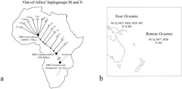
Mitochondrial DNA offers a particularly useful perspective because it is generally inherited through the maternal line. Certain variations can be grouped into maternal lineages, allowing researchers to investigate relationships among populations and trace aspects of ancient ancestry.

However, mitochondrial DNA represents only one part of a person's genetic history. It cannot independently reconstruct every migration, establish a complete family tree, or explain the cultural identity of an ancient community. Its value is greatest when combined with genome-wide ancient DNA, archaeological chronology, and other evidence of human movement.

What Mitochondrial DNA Reveals

Mitochondria are structures within cells that help produce energy. They contain their own small genome, distinct from the much larger genome housed in the cell nucleus. In most cases, mitochondrial DNA is inherited from the mother, making it useful for studying maternal ancestry across generations.

Researchers identify genetic variations that accumulate over time. Groups of related mitochondrial sequences are classified into haplogroups and more specific branches, or sublineages. Their distribution across ancient and modern populations can help investigate shared ancestry and historical movement.

A maternal lineage may be common in several island communities because of a shared ancestral population, later migration, or repeated contact between islands. Its presence does not necessarily mean that the communities descend from one recent migration, and its absence does not prove that no historical contact occurred.

Mitochondrial DNA also follows only one narrow line of ancestry. A person has many genealogical ancestors across successive generations, but their mitochondrial DNA traces just one maternal chain. Other ancestors contribute genetic material through different branches of the family tree that this single marker does not capture.

The Settlement of Oceania

The broad settlement history of Oceania includes different movements through Island Southeast Asia, Near Oceania, and Remote Oceania. These regions encompass distinct environments and archaeological histories, and they should not be treated as one uniform migration zone.

Archaeological evidence documents the expansion of communities associated with the Lapita cultural complex into parts of the western Pacific several thousand years ago. Lapita sites are recognized through distinctive material traditions, including pottery, but the spread of an archaeological culture does not automatically mean that every artifact-bearing community had the same genetic ancestry.

The settlement of Remote Oceania required long-distance voyaging across open ocean to islands that were not always visible from one another. These voyages involved navigational knowledge, maritime technology, and the ability to establish communities in new environments.

Genetic evidence can help investigate the ancestry of people involved in these movements. Yet migration routes must be reconstructed using several kinds of data, because genetic similarity alone does not establish the exact direction, timing, or circumstances of a voyage.

Ancient DNA and the Reconstruction of Maternal Lineages

Ancient DNA can be recovered from suitable human remains, particularly when preservation conditions have limited the degradation of genetic material. Laboratories use specialized methods to extract and sequence DNA while monitoring contamination from modern sources.

Researchers then compare ancient sequences with those from other archaeological individuals and modern populations. These comparisons can reveal whether a lineage was present in a region during a particular period and whether it shares ancestry with lineages found elsewhere.

The quality of evidence depends on sample size and preservation. A single ancient individual can provide an important observation, but cannot represent the full genetic diversity of an entire island population. Larger, chronologically distributed samples are needed to investigate changes in ancestry through time.

Ancient DNA analysis also requires careful ethical practice. Human remains are not simply scientific specimens; they may be connected to descendant communities, cultural traditions, and questions of ancestral stewardship. Research should follow relevant legal requirements, consultation procedures, and community expectations.

Maternal Ancestry, Migration, and Population Interaction

Mitochondrial lineages can provide clues about population movement, especially when changes in their distribution are observed across securely dated samples. For example, a lineage appearing in a region at a later date may indicate migration, but researchers must also consider sampling gaps and the possibility that the lineage was present earlier but has not yet been detected.

Population interaction can produce complex genetic patterns. Communities may exchange marriage partners, move between islands, or become incorporated into larger political and social networks. Over generations, these processes can alter the distribution of maternal lineages.

A change in mitochondrial DNA frequencies does not necessarily imply the replacement of an entire population. It could reflect the movement of a relatively small number of people, differences in reproductive success, demographic changes, or the loss of certain lineages through chance.

The distinction between genetic ancestry and cultural identity is especially important. People may adopt new languages, technologies, social practices, and identities without undergoing complete genetic replacement. Conversely, populations with related ancestry may develop very different cultural traditions.

The Limits of Mitochondrial Evidence

One of the most common interpretive mistakes is to treat a mitochondrial lineage as a precise marker of an ethnic group. Genetic lineages often cross cultural and linguistic boundaries, and their distributions can change substantially over time.

Another difficulty is that maternal inheritance does not capture all forms of migration equally. If movement involved more men than women, or if communities had different patterns of marriage and residence, mitochondrial evidence might record the process differently from genome-wide DNA or paternal-line markers.

Genetic drift can also influence lineage frequencies. In small island populations, random changes across generations may cause certain maternal lineages to become common or disappear. This can produce striking genetic patterns even without repeated large-scale migration.

Finally, the absence of ancient DNA from a particular period or island may reflect poor preservation or limited sampling rather than an absence of people. Genetic reconstructions must account for these gaps and avoid presenting incomplete evidence as a definitive migration map.

Integrating Genetics with Archaeology and Navigation History

The strongest reconstructions combine genetic findings with material and environmental evidence. Archaeological sites establish when people occupied islands, while artifacts, settlement patterns, and food remains help reconstruct how communities lived.

Linguistics can contribute evidence of relationships among languages, although linguistic histories do not always match genetic histories directly. Comparative studies may identify broad patterns of contact and expansion, but they must account for language change, borrowing, and cultural transmission.

Paleoclimate and environmental studies can also clarify the conditions under which voyaging occurred. Island resources, prevailing winds, currents, and changes in coastal environments influenced the practical possibilities of settlement and travel.

When genetic, archaeological, and linguistic evidence converge, a migration hypothesis becomes more persuasive. When they disagree, the differences can be equally informative, potentially revealing multiple movements, uneven population mixing, or distinct histories of cultural and biological change.

Conclusion: A Complex Ancestry Across the Pacific

Ancient mitochondrial DNA provides a valuable perspective on the settlement of Oceania. It helps researchers investigate maternal ancestry, population relationships, and changes in lineage distributions across time.

But mitochondrial DNA cannot independently identify a complete migration route or define an entire community's identity. Its evidence must be interpreted alongside archaeological chronology, genome-wide data, linguistic research, and the history of interactions among island populations.

The genetic history of Oceania is not a simple story of one people moving in one direction. It is a complex record of voyaging, settlement, adaptation, and connection across generations. By combining multiple disciplines, researchers can better understand the human experiences behind those movements while recognizing the diversity and continuing significance of Pacific communities.

Mudbrick Microstructures: Reconstructing Building Recipes Across Cultures

October 18, 2026

How microscopic analysis of earth-based building materials can reveal construction knowledge, resource choices, and technological traditions across ancient societies.

Introduction: The Science Hidden Inside Mudbrick

Mudbrick is one of the oldest and most widespread building materials in human history. Produced from earth mixed with varying amounts of water and sometimes organic or mineral additives, it has been used for houses, storage facilities, defensive structures, temples, and monumental architecture.

Its apparent simplicity can be misleading. Mudbrick construction requires decisions about soil selection, water content, mixing, molding, drying, and the placement of bricks within a building. Builders may have adjusted these choices according to local materials, climate, the intended function of a structure, and inherited construction traditions.

Many mudbrick buildings have deteriorated through erosion, flooding, abandonment, or later rebuilding. Even where walls survive, the original construction process may not be immediately visible. Microscopic analysis provides a way to investigate the composition and internal structure of the material.

By examining mineral grains, pores, plant fibers, clay particles, and other microscopic features, researchers can begin reconstructing how ancient builders prepared their materials. Such analysis can reveal technical choices, but it must be interpreted carefully: similar materials do not necessarily indicate shared cultural origins, and differences do not always represent different traditions.

What Is a Mudbrick Microstructure?

A mudbrick is a composite material. Its properties depend on the proportions and characteristics of its constituents, including clay, silt, sand, gravel, water, and any added organic matter.

At a microscopic scale, these components form a complex arrangement. Grain size and shape affect how particles fit together, while clay minerals influence plasticity and cohesion. Pores and voids affect the movement of water and the material's resistance to stress.

Organic inclusions may include straw, grasses, chaff, or other plant material. Depending on the construction method, these may help manage shrinkage, alter the brick's texture, or change its mechanical behavior. Their function should be tested rather than assumed, because the effects depend on the type and quantity of the additive.

Microscopic examination can identify patterns that are difficult to observe with the naked eye. Researchers may distinguish natural inclusions in the source soil from materials deliberately added during manufacture. However, this distinction is not always straightforward, especially when the local soil naturally contains plant fragments or diverse mineral grains.

Sampling and Laboratory Analysis

The first stage of a study is to select samples that represent the structure's different construction phases and locations. A single brick may not capture the full range of materials used throughout a building, particularly if repairs or rebuilding occurred over time.

Researchers may use optical microscopy to examine thin sections of the brick. In a thin section, the material is sliced sufficiently thin for transmitted light to reveal its mineral composition and internal organization.

Additional methods can answer more specific questions. Scanning electron microscopy can reveal fine surface features, while X-ray diffraction may help identify clay and other crystalline minerals. Elemental analysis can characterize chemical composition, although chemical similarities do not automatically identify a specific source.

Particle-size analysis can help characterize the sediment used in construction. Porosity measurements and other material tests may clarify how the brick was formed and how it has responded to moisture and weathering.

All these methods have limitations. Conservation treatments, burial conditions, salt accumulation, and contamination can alter the sample. Researchers must document the object's history and compare results with local geological materials before making claims about the original building recipe.

Reconstructing the Building Recipe

A building recipe refers to the combination of raw materials and preparation choices used to create a construction material. Archaeologists may infer aspects of this recipe by comparing the proportions of clay, sand, plant matter, and other inclusions across bricks.

If bricks contain unusually consistent mixtures, this may suggest a standardized preparation process. Yet consistency can also result from a naturally uniform clay deposit. To demonstrate deliberate standardization, researchers should compare the bricks with available raw materials and investigate whether the observed composition exceeds what the local geology would predict.

Differences between bricks may indicate separate production batches, repairs, distinct workshops, or changes in construction practice. Such interpretations become stronger when compositional variation corresponds with architectural phases or other independent evidence.

Experimental archaeology can also contribute. Researchers may reproduce bricks using plausible local materials and vary the proportions of clay, sand, water, and organic additives. By comparing the resulting microstructures and performance with archaeological specimens, they can test whether a proposed manufacturing method is feasible.

Experimental success does not prove that ancient builders used exactly the same recipe. Several combinations of materials can produce similar structures, so the results should be treated as evidence of plausibility rather than a unique reconstruction.

Local Resources and Long-Distance Connections

Mudbrick is usually associated with locally available earth, but the materials and techniques used to produce it can still reflect wider connections. Builders may have adopted construction methods from neighboring communities, employed specialists, or used materials transported from elsewhere.

Distinguishing local production from imported material requires geological comparison. Mineral composition, grain characteristics, and chemical signatures may help identify whether a brick resembles nearby soil sources. However, common geological materials can occur across broad regions, and compositional similarity alone may not establish a precise origin.

Construction techniques can also spread without the movement of raw materials. A community might adopt a method for mixing or molding earth after contact with neighboring builders while continuing to use local clay and sand.

Conversely, buildings that look similar may have been constructed independently because the same materials and environmental conditions favored similar solutions. Researchers should therefore avoid treating architectural resemblance as proof of cultural identity or direct contact.

The most convincing evidence of technological exchange combines material analysis with chronology, architectural comparison, and independent indicators of interaction.

Climate, Durability, and Building Performance

The composition of mudbrick influences how it responds to environmental conditions. Water is particularly important because prolonged moisture can weaken earth-based materials, encourage erosion, and damage the surfaces of walls.

Clay content, particle size, porosity, and organic inclusions all affect performance, but the relationships are complex. A material that works well in one climate may perform poorly in another. Local construction traditions may therefore reflect generations of experience with rainfall, seasonal humidity, wind, and available building resources.

Researchers can investigate these relationships by examining weathering patterns and comparing the composition of surviving bricks with the surrounding environment. Experimental tests may evaluate strength, water absorption, drying behavior, and resistance to erosion.

However, present-day performance does not fully reproduce ancient conditions. Soil chemistry may have changed during burial, while salts, vegetation, and later repairs can affect preservation. A brick's current condition should not be treated as a direct measure of its original properties.

Standardization, Labor, and Social Organization

Building a mudbrick structure requires more than raw materials. Someone must gather earth, prepare mixtures, shape bricks, dry them, transport them, and place them within the building. The scale and consistency of this work can provide clues about labor organization.

Large construction projects may have required coordinated labor and substantial preparation, while small domestic buildings could have been produced by households or local work groups. Yet the number of bricks alone does not reveal whether workers were paid, conscripted, or participating in communal activity.

Standardized brick dimensions and composition may suggest shared working procedures. If these patterns appear across multiple buildings, they may indicate the existence of common technical conventions or organized production. Archaeologists still need to determine whether the similarity reflects centralized oversight, local custom, or practical constraints.

Microstructural analysis contributes by showing how construction materials were prepared. When combined with architectural scale, tool evidence, settlement organization, and historical documentation, it can help investigate the labor and knowledge systems behind ancient buildings.

Conservation and the Preservation of Earthen Architecture

Mudbrick structures are often vulnerable to water, wind, salt crystallization, and uncontrolled vegetation. Conservation efforts must balance the need to protect the material with the importance of retaining its original composition and appearance.

Understanding microstructure can help conservators choose suitable interventions. A repair material that is too hard or impermeable may damage the original fabric, while an incompatible mixture can accelerate deterioration. Conservation materials should therefore be tested for compatibility with the existing brick and its environmental conditions.

Documentation is essential before intervention. Researchers record the composition, condition, and distribution of different materials so that future changes can be monitored. Where possible, minimally invasive methods help preserve original material for future study.

The broader lesson is that mudbrick should not be dismissed as an inferior or temporary building material. Its survival depends on environmental conditions and maintenance, and many earthen structures represent sophisticated adaptations to local resources and construction needs.

Conclusion: Reconstructing Ancient Technology from Earth

The microscopic study of mudbrick opens a window into the technical decisions behind ancient architecture. Mineral grains, pores, clay particles, and organic inclusions can reveal how builders selected and prepared materials, adapted to environmental conditions, and maintained construction traditions.

These features do not automatically identify a cultural group or prove contact between distant societies. Similar recipes can emerge independently, while a single building may contain several construction phases and material sources.

By combining microstructural analysis with geological comparison, architectural recording, experimental research, and secure chronology, archaeologists can move beyond the appearance of ancient walls to investigate the knowledge embedded within them.

Mudbrick may be made from ordinary earth, but its microstructure preserves traces of deliberate human choices. Those choices connect geology, labor, environmental adaptation, and cultural transmission—demonstrating how even the most familiar building materials can preserve a sophisticated technological history.

Portable Altars: Small-Scale Religious Practice in Hellenistic Marketplaces

October 18, 2026

Exploring how movable ritual objects can illuminate personal devotion, commercial life, and religious practices in the busy marketplaces of the Hellenistic world.

Introduction: Religion Beyond Monumental Sanctuaries

The Hellenistic period, conventionally dated from the death of Alexander the Great in 323 BCE to the Roman conquest of the Ptolemaic kingdom in 30 BCE, was characterized by political change, expanding trade networks, and the growth of cities across the eastern Mediterranean and beyond. Monumental temples and public sanctuaries remain among the most visible expressions of religious life from this era, but they were not the only places where people engaged with the divine.

Marketplaces brought together merchants, craftspeople, travelers, customers, officials, and visitors from different backgrounds. These spaces were primarily associated with economic and civic activity, yet religious practices could also occur within or around them. Small altars, incense burners, offering vessels, figurines, and other ritual objects may provide evidence for forms of devotion that took place outside major sanctuaries.

Portable altars are particularly interesting because their mobility allowed them to be used in different settings. A small altar could potentially serve a household, a shop, a workshop, a traveling merchant, or a temporary gathering. However, an altar found in a marketplace does not automatically prove that religious ceremonies took place there. It could have been discarded, stored, reused as building material, or moved from another location.

The challenge is to reconstruct the object's original function and context without assuming that every religious artifact represents a formal public ceremony.

What Makes an Altar Portable?

An altar is generally understood as a structure or object associated with offerings, sacrifice, or other acts of religious observance. Portable examples may be small enough to carry, constructed from materials that permit movement, or designed for use in temporary settings.

Their materials could include stone, terracotta, metal, or other locally available substances. Some objects might have been deliberately designed as miniature versions of larger altars, while others may have served multiple functions depending on the circumstances.

Researchers examine dimensions, weight, construction, surface wear, residues, and decorative features to investigate whether an object was intended to be moved. Handles, stable bases, and repeated patterns of burning or deposition may provide useful clues, although no single feature is decisive.

The distinction between a portable altar and a small fixed altar can be difficult to establish. An object may have been movable in principle but remained in one location for years. Conversely, a stone feature that appears permanent might have been relocated during rebuilding or changes in ownership.

Archaeologists therefore consider the object's physical properties alongside its findspot, surrounding deposits, and relationship to architecture.

The Marketplace as a Religious Environment

Hellenistic marketplaces were not simply commercial zones separated from the rest of civic life. In many cities, market areas formed part of larger complexes that included public buildings, stoas, administrative spaces, monuments, and routes used for civic gatherings.

Such settings could create opportunities for religious activity. Merchants might seek divine protection for voyages or transactions, craftspeople might observe local customs, and visitors might make offerings connected to travel, health, prosperity, or personal obligations.

These possibilities should not be treated as universal practices. The organization of marketplaces varied considerably across regions, and the evidence for religious activity differs from one archaeological site to another.

A convincing interpretation begins with spatial context. Was the object recovered near a shop, a public monument, a small shrine, or a domestic structure? Was it found in a deposit associated with repeated burning or offering activity? Were comparable objects found in similar positions elsewhere in the city?

When several lines of evidence converge, the possibility of religious activity within a commercial setting becomes more persuasive.

Reading Ritual Traces on Small Objects

Portable altars may preserve physical evidence of use. Soot, ash, discoloration, and heat alteration can indicate exposure to fire, while residues may sometimes reveal the burning of plant or animal materials.

Yet traces of burning are not exclusive to religious activity. A small object might have been exposed to a cooking fire, damaged in a building fire, or reused for another purpose. Researchers must determine whether the pattern of alteration is consistent with deliberate ritual use.

Microscopic analysis can help distinguish repeated heating from a single accidental event. Residue analysis may identify certain organic compounds, although preservation conditions and contamination can limit the reliability of the results.

Inscriptions and decorative motifs may provide further clues. An inscription naming a deity or identifying a dedication can strengthen the religious interpretation, but its meaning still depends on context. An object associated with a deity might have been a votive offering rather than an altar used for repeated ceremonies.

The strongest interpretations combine physical traces, inscriptions, iconography, and the spatial organization of the archaeological site.

Religion, Commerce, and Personal Identity

Small ritual objects can reveal how religious practices intersected with work and travel. A merchant operating far from home might have carried familiar religious objects, while a local craftsperson could have maintained practices associated with a household or professional group.

However, the identity of the user cannot usually be inferred from an object's location alone. A portable altar found in a commercial district might have belonged to a shopkeeper, a visitor, a religious specialist, or someone whose connection to the marketplace is no longer recoverable.

The Hellenistic world also included communities with different languages, customs, and religious traditions. Commercial settings could bring people into contact with unfamiliar practices, but this does not mean that every marketplace was religiously diverse in the same way.

Archaeologists investigate these relationships through inscriptions, imported objects, architectural context, and comparisons between local and regional material traditions. They must avoid equating artistic resemblance with a person's ethnic identity or assuming that an imported object necessarily belonged to a foreign resident.

Testing the Evidence for Marketplace Ritual

A rigorous investigation begins by reconstructing the archaeological context of each object. Researchers establish the date of the deposit, identify associated structures, and determine whether the object was found in primary or secondary deposition.

The next step is comparison. If portable altars occur repeatedly in shop interiors, near market entrances, or beside other evidence of offerings, the pattern may suggest that ritual activities formed part of commercial life.

Conversely, if the objects appear only in later rubbish deposits or building fill, their original location may be uncertain. They may have been collected from nearby shrines or domestic spaces before being discarded.

Historical texts can provide valuable context, but descriptions of religious practices should not automatically be applied to every Hellenistic city. Archaeological evidence is needed to establish whether a documented practice occurred at the site under investigation.

Conclusion: Small Objects, Everyday Devotion

Portable altars offer a promising way to investigate religious activity beyond monumental sanctuaries. Their materials, traces of use, inscriptions, and archaeological contexts can reveal how devotion may have intersected with trade, work, and movement in the Hellenistic world.

However, mobility does not prove that an object was used in a marketplace, and a marketplace findspot does not establish that the object was used there for religious purposes. These interpretations require careful contextual analysis.

By combining artifact study, residue analysis, spatial reconstruction, and historical comparison, archaeologists can investigate how religious practice may have occupied the same spaces as everyday economic life. Such research broadens our understanding of Hellenistic religion by considering not only public temples and official ceremonies, but also the smaller objects through which people may have expressed personal devotion.

The Archaeology of Icehouses and Ancient Refrigeration Systems

October 18, 2026

Investigating how communities stored ice, cooled food, and managed seasonal temperatures before mechanical refrigeration.

Introduction: Keeping Things Cold Before Electricity

Modern refrigeration depends on machinery, electricity, and carefully controlled systems of heat transfer. Before these technologies existed, people developed other ways to keep food and drink cool, extend storage life, and take advantage of seasonal cold.

These methods varied widely according to climate, geography, available materials, and social organization. Communities in colder regions could collect winter ice or snow and preserve it for use during warmer months. Other societies used underground chambers, shaded storage spaces, evaporative cooling, cool springs, or naturally cold environments to reduce temperatures.

The archaeological study of icehouses examines the structures and practices associated with such storage. These buildings and chambers can reveal how people managed food supplies, organized labor, and adapted architecture to local environmental conditions.

The term “ancient refrigeration,” however, must be used carefully. Ice storage and passive cooling are not equivalent to modern refrigeration, and not every underground storage structure was an icehouse. A convincing identification requires architectural, environmental, and contextual evidence.

How Icehouses Worked

An icehouse is generally a structure designed to store harvested ice or snow for later use. Many historical examples used thick walls, insulated roofs, underground chambers, drainage systems, and restricted openings to slow melting.

The basic principle is straightforward: ice absorbs heat as it melts, while insulation and limited exposure to warm air slow the transfer of energy into the storage space. Water must also be drained or managed to prevent the remaining ice from sitting in accumulated meltwater.

Different designs suited different environments. Underground chambers could benefit from relatively stable soil temperatures, while above-ground structures relied more heavily on insulation and shade. Some facilities were built near lakes, ponds, or rivers where ice could be harvested during cold periods.

The effectiveness of a system depended on more than the presence of ice. Insulation, chamber size, airflow, drainage, the quality of the stored ice, and the frequency of opening all influenced performance.

Archaeologists can investigate these features by recording wall construction, chamber dimensions, floor levels, drainage channels, and the relationship between the structure and its surroundings.

Distinguishing Icehouses from Other Storage Structures

Underground chambers have served many purposes, including food storage, grain storage, water management, burial, and industrial activity. A deep pit or stone-lined room cannot be identified as an icehouse based on its shape alone.

Researchers look for features consistent with ice storage, such as effective insulation, drainage, a design suited to retaining cold, and a location where ice could plausibly have been obtained. Historical records may describe the structure's use, while associated artifacts can provide chronological clues.

The surrounding landscape is equally important. Proximity to a former pond or lake may support the possibility of ice harvesting, but modern water features may differ from those available when the structure was built.

Environmental reconstruction can help determine whether seasonal freezing was sufficiently reliable. In regions where natural ice was scarce, a proposed icehouse may be more plausibly interpreted as a cool store or cellar unless additional evidence supports ice storage.

The identification should remain proportional to the evidence. A structure may be described as a possible icehouse if its function is plausible but not firmly established.

Food Preservation, Medicine, and Social Status

Cold storage could help preserve certain foods, chill drinks, and provide temporary relief from heat. Its value varied according to the local climate and the types of goods being stored.

Icehouses could also have served elite households, institutional kitchens, hospitals, or commercial establishments. Access to harvested ice required labor, storage space, and favorable environmental conditions, which could make the service expensive in some settings.

However, ice storage should not be assumed to have been exclusively elite. Communities could develop practical cold-storage methods using local materials and shared labor. The social distribution of such technology must be investigated through specific archaeological and historical evidence.

Cold storage also had limits. Ice could slow deterioration but did not sterilize food, and the effectiveness of preservation depended on temperature, cleanliness, and storage duration. Ancient users may have understood the practical benefits of cold without possessing a modern scientific explanation of microbial growth.

Reconstructing the Ice Supply Chain

An icehouse depended on a sequence of activities: obtaining ice, transporting it, preparing the storage chamber, packing the material, and retrieving it when needed.

Archaeologists can investigate these activities through landscape analysis, transport routes, associated buildings, and documentary evidence. If an icehouse stood near a frozen lake, for example, the distance between the water source and the storage facility may help estimate the logistical demands of harvesting.

Tools and equipment associated with cutting, lifting, or transporting ice may occasionally survive, but many were made of perishable materials. Their absence does not mean that ice harvesting did not occur.

The supply chain could also be seasonal. Ice might be collected during the coldest part of the year and stored for warmer months. Establishing this pattern requires environmental evidence and, where possible, historical records describing the timing of collection and use.

Climate, Architecture, and Technological Adaptation

Icehouses illustrate how architecture can compensate for environmental variability. Builders used earth, stone, timber, thatch, and other materials to reduce heat gain and create spaces with relatively stable temperatures.

Different climates demanded different solutions. In humid environments, ventilation and drainage could be important, while colder regions might emphasize insulation and the protection of stored ice from direct sunlight.

Archaeological comparisons can reveal whether builders adopted similar techniques independently or transmitted construction knowledge between communities. Yet architectural resemblance alone cannot establish direct contact, because comparable environmental problems can lead to similar designs.

Experimental reconstruction can help test how well a proposed design would have retained ice. Researchers may model heat transfer or construct replicas using historically plausible materials. Such experiments demonstrate the potential performance of a design, but they cannot establish that an ancient structure was used in exactly the same way without supporting contextual evidence.

Conclusion: Cooling as a Historical Technology

Icehouses and other passive cooling systems reveal how people managed temperature before mechanical refrigeration. Their construction reflects practical knowledge of insulation, drainage, seasonal conditions, and the movement of perishable goods.

Archaeologists must distinguish true icehouses from cellars and other storage structures through a combination of architecture, environmental reconstruction, and historical evidence. The presence of a deep chamber or cool interior is not sufficient by itself.

When the evidence converges, these structures illuminate the labor and ingenuity involved in preserving ice and controlling temperature. They also demonstrate that refrigeration history did not begin with electricity: it grew from many local experiments in architecture, environmental observation, and resource management.

Gossypium Genomics: Tracing Cotton Domestication Paths in the Old World

October 18, 2026

How ancient DNA, plant genetics, and archaeological evidence can help reconstruct the domestication and spread of cotton across the Old World.

Introduction: The Genetic History of a Global Fiber

Cotton has played a major role in the history of clothing, agriculture, trade, and industrial production. Its soft fibers can be spun into yarn and woven into textiles, making it one of the most economically significant plant resources in human history.

The cotton genus, Gossypium, includes numerous wild and cultivated species. Different species were domesticated in different parts of the world, and their histories should not be collapsed into a single origin story. Cotton's global importance emerged through multiple domestication processes, human selection, plant movement, and later hybridization.

Genomics provides a way to investigate these processes. By comparing genetic variation among wild and cultivated cotton plants, researchers can explore relationships between populations, identify signs of domestication, and investigate how cultivated varieties changed as people moved seeds across regions.

The Old World is especially important because several cotton species native to Africa and Asia contributed to the development of ancient and historical textile traditions. However, genetic evidence alone cannot establish exactly when a community first cultivated cotton or when cotton textiles became economically important. Archaeological evidence remains essential.

The Diversity of the Cotton Genus

The genus Gossypium contains species adapted to a range of environments, from dry regions to tropical and subtropical landscapes. Their evolutionary histories are complex, and the relationships among species provide important clues about cotton's development as a cultivated crop.

Two Old World species are particularly significant: Gossypium arboreum and Gossypium herbaceum. Both have long histories of cultivation, although their precise domestication histories and the relationships among ancient cultivated populations remain subjects of scientific investigation.

Other species, including New World cottons, contributed to the later global history of the crop. The movement of cotton plants between regions created opportunities for hybridization and genetic exchange, especially as agricultural and commercial networks expanded.

Researchers use genomic data to compare cultivated cotton with wild relatives. These comparisons can help identify genetic diversity that was retained, lost, or selected during domestication. They can also reveal whether modern varieties preserve traces of older breeding histories.

However, modern genetic diversity has been shaped by centuries of selection, migration, and agricultural change. A modern plant's closest genetic relative is not necessarily the exact wild population from which an ancient crop was domesticated.

Domestication as a Process of Selection

Domestication is not a single moment when a wild plant suddenly becomes cultivated. It is a process through which human management and selection gradually alter a population's characteristics.

For cotton, useful traits include fiber length, fiber quality, seed characteristics, growth habit, and adaptation to local environments. Farmers may have selected plants that produced better fibers or more reliable yields, even without understanding the genetic mechanisms underlying these differences.

Genomics can identify regions of the genome associated with traits that changed during domestication. Researchers compare genetic variation in wild and cultivated plants and investigate whether certain regions show patterns consistent with selection.

These findings must be interpreted cautiously. Genetic patterns can also arise through population bottlenecks, inbreeding, migration, and other demographic processes. Evidence for selection becomes stronger when genomic results correspond with known plant biology and observed differences in traits.

Archaeobotanical evidence can help establish the chronology of cultivation. Seeds, fiber fragments, impressions on artifacts, and other plant remains may provide evidence of cotton use, but their preservation and identification vary considerably.

Reconstructing Old World Cotton Movement

Cotton spread through networks of exchange that connected agricultural communities, textile producers, merchants, and consumers. Seeds could move with migrating farmers, traders, or people seeking suitable crops for new environments.

Genetic comparisons can reveal relationships among cultivated populations across regions. If populations share particular genetic patterns, researchers may investigate whether they reflect common ancestry, later movement, or exchange between cultivated varieties.

Yet genetic similarity does not necessarily identify the direction of movement. Researchers need chronological information from archaeological sites and historical records to determine which explanations are plausible.

The distinction between moving a plant and moving a textile is also important. Cotton fabric could circulate widely without cotton being cultivated locally. Conversely, a community might grow cotton for local use without participating in long-distance textile trade.

Archaeological evidence of seeds and cultivation must therefore be distinguished from evidence of finished cloth, which may have been imported.

Ancient DNA and the Challenges of Plant Preservation

Recovering ancient DNA from cotton remains can be difficult. Heat, moisture, microorganisms, and chemical changes degrade genetic material, and plant fibers may preserve poorly in many environments.

Where suitable samples survive, researchers can use specialized extraction and sequencing methods to investigate their genetic composition. Strict contamination controls are necessary because modern cotton fibers and laboratory materials can introduce misleading signals.

Ancient DNA may help connect archaeological specimens to known genetic lineages. However, a specimen's context and date remain crucial. Cotton fibers found in a later deposit may have been introduced through contamination or the movement of textiles, while a seed may have been transported far from where the plant originally grew.

Researchers therefore combine genetic evidence with microscopy, plant morphology, radiocarbon dating of appropriate material, and archaeological context.

Cotton, Labor, and Economic Transformation

Cotton's genetic history is inseparable from its social history. Cultivation and textile production required land, labor, processing knowledge, and systems for distributing raw fibers and finished cloth.

Different communities organized these activities in different ways. Cotton could be produced for household needs, regional exchange, taxation, or larger commercial markets. Its importance depended on local agricultural conditions and the availability of alternative fibers.

Genomic research cannot independently reconstruct these labor systems, but it can clarify how cultivated plants changed as they moved between regions. Archaeological textiles, spinning tools, loom weights, seeds, and documentary sources provide the broader context.

The history of cotton also requires attention to the unequal social arrangements that shaped its production in later periods. Genetic evidence can illuminate the movement of the crop, but it should not obscure the human labor and economic relationships that made cotton a major commodity.

Conclusion: Reconstructing Cotton's Multiple Origins

Gossypium genomics offers valuable tools for investigating cotton domestication, crop movement, and the genetic changes associated with cultivation. It can help identify relationships among wild and cultivated populations and generate hypotheses about how cotton spread across the Old World.

However, no single genetic pattern can establish a complete domestication route. Modern plants preserve the effects of many later changes, while ancient botanical remains are unevenly distributed and often poorly preserved.

The most reliable reconstruction combines genomic analysis with archaeobotany, textile studies, historical evidence, and agricultural research. Together, these disciplines reveal cotton not as a crop with one simple origin, but as a plant shaped by multiple communities, environments, and histories of human selection.

Bronze Age Roadside Cemeteries: Mobility and Mortuary Variation

October 18, 2026

Exploring how burial locations, grave goods, and human remains can reveal movement, identity, and social relationships in Bronze Age landscapes.

Introduction: Burials Along Routes of Movement

The Bronze Age was a period of substantial variation across Europe, Asia, Africa, and other regions. Communities developed distinctive systems of metalworking, agriculture, settlement, exchange, and burial. In many areas, routes connecting settlements, grazing lands, water sources, and trading centers became important parts of everyday life.

Cemeteries located near routes of movement can offer a valuable perspective on these relationships. Their position may reflect practical considerations, territorial boundaries, social visibility, or the long-term use of a landscape. Yet the phrase “roadside cemetery” must be applied cautiously to prehistoric contexts because many modern roads did not exist during the Bronze Age.

A line of graves beside a present-day road might originally have been associated with a river crossing, a ridge route, a seasonal path, or a boundary. It may also have been located there for reasons unrelated to travel.

Archaeologists investigate these possibilities by reconstructing the ancient landscape and examining the burial practices, chronology, and biological histories of the individuals interred there.

Identifying Routes in Bronze Age Landscapes

Roads and paths are not always preserved as clear physical structures. Some may have followed natural corridors, including valleys, riverbanks, passes, and ridgelines. Others may have consisted of repeated tracks formed by people and animals rather than engineered surfaces.

Archaeologists use terrain analysis, remote sensing, excavation, and environmental reconstruction to identify plausible movement corridors. Depressions, worn surfaces, trackways, bridges, and associated settlement patterns can provide evidence of repeated travel.

However, the presence of a route near a cemetery does not prove that the cemetery was established to serve travelers. The graves may have been placed along a boundary, beside a settlement entrance, or near a landmark that was important for other reasons.

A strong interpretation requires chronological compatibility. Researchers must determine whether the route and cemetery were used during overlapping periods. A path visible in the landscape today may have developed after the burials were created.

Mortuary Variation and Social Identity

Bronze Age burials vary widely in form. Some individuals were buried in simple graves, while others received elaborate containers, stone structures, ornaments, weapons, tools, or other objects. Practices differed across regions and changed over time.

Archaeologists examine these differences to investigate social organization and identity. Grave goods may reflect age, gendered social expectations, occupation, status, ritual obligations, or the choices of surviving relatives.

Yet grave goods are not direct inventories of personal wealth. Objects may have been selected for symbolic reasons, and some valuable possessions might have been retained by the living rather than placed in graves. The absence of grave goods does not necessarily indicate poverty or low social status.

Variation within a cemetery can reveal whether people followed shared mortuary conventions or whether distinct burial traditions coexisted. Differences may also reflect changes across generations rather than social divisions among contemporaries.

The relationship between burial variation and mobility becomes particularly interesting when grave practices differ from those typical of nearby settlements. Such differences can suggest connections with other regions, but they must be evaluated against local chronological and cultural evidence.

Isotopes and the Movement of Individuals

Stable isotope analysis can help investigate where individuals spent parts of their lives. Strontium isotopes in tooth enamel reflect aspects of the geological environments from which people obtained food and water during tooth formation. Oxygen isotopes can provide additional information related to drinking water and environmental conditions.

Researchers compare these measurements with regional baselines to assess whether an individual's childhood environment was consistent with the location where they were buried.

The method has important limitations. Similar isotope values can occur in different regions, and geological or environmental variation within one region may be substantial. A result outside the local range can suggest movement without identifying a precise birthplace.

Different tissues record different periods of life. Tooth enamel generally reflects conditions during childhood, while bone can remodel and incorporate information from later years. Comparing them may help investigate whether a person moved during their lifetime, although preservation and individual biology affect interpretation.

Genetic evidence may add information about biological relationships and ancestry. However, ancestry, birthplace, language, and cultural identity are different questions. A person with genetic affinities to another region may have grown up locally or belonged to a family that had moved generations earlier.

Burial Locations and the Social Geography of Travel

Cemeteries beside routes may have occupied visible positions in the landscape. If this pattern is confirmed, researchers can investigate whether visibility served a social function, such as marking territory, maintaining collective memory, or connecting the dead with important movement corridors.

However, visibility alone does not establish intent. A cemetery may occupy a prominent location because the terrain offered suitable ground, because the area was already associated with settlement, or because the route developed around an earlier burial place.

Researchers can use geographic information systems to compare graves with viewsheds, slopes, water sources, settlement locations, and reconstructed routes. Such analysis can identify spatial relationships that are difficult to recognize through excavation alone.

The chronological sequence is essential. If the cemetery predates the route, the relationship may reflect later changes in movement. If the route was already in use, the placement of graves may have been more closely connected with the travel corridor.

Death, Movement, and Community Membership

Mobility did not necessarily weaken a person's relationship with a community. Travelers, craftspeople, pastoralists, traders, and people who moved through marriage or family connections could participate in several social networks during their lives.

Burial practices may reveal how communities incorporated people with different backgrounds. An individual who grew up elsewhere but received a local burial might have been accepted into the community through family ties, residence, or social obligations.

Conversely, distinctive burial treatment could indicate that a person was regarded as different from others in the cemetery. Yet such interpretations are difficult to establish from grave goods alone. Researchers need to consider biological evidence, chronology, and patterns across multiple burials.

The archaeological record is therefore unlikely to provide a simple distinction between local people and outsiders. Mobility was often gradual, repeated, and socially complex.

Conclusion: Cemeteries as Records of Movement and Belonging

Bronze Age cemeteries associated with routes of movement can illuminate the relationship between travel, landscape, and social identity. Burial location, mortuary variation, isotope analysis, and genetics can help researchers investigate where people lived and how communities responded to mobility.

The evidence must be interpreted carefully. A cemetery near a modern road is not automatically a roadside burial ground in the prehistoric sense, and an individual's non-local isotope signature does not by itself establish their social identity.

By reconstructing ancient routes and combining burial analysis with scientific evidence, archaeologists can explore how Bronze Age communities understood belonging, movement, and remembrance. Cemeteries become more than collections of graves: they become records of how people and places were connected across a changing landscape.

The Ritual Use of Fire in Caves: Soot Layers and Smoke Residues

October 18, 2026

How combustion residues, hearth locations, and cave-wall deposits can help distinguish practical fire use from possible ceremonial activity.

Introduction: Fire in the Depths of the Earth

Caves have served many purposes throughout human history. People used them for shelter, temporary occupation, resource extraction, burial, artistic expression, and other activities that varied by period and region. Fire could make these spaces more habitable by providing warmth, light, and a means of preparing food.

Fire also has properties that may have made it important in ceremonial settings. Flames illuminate otherwise dark spaces, smoke changes the atmosphere of an enclosed chamber, and the act of lighting or maintaining a fire can structure collective activity. These qualities make cave fires a compelling subject for archaeological investigation.

However, fire in a cave does not automatically indicate ritual practice. A hearth may have been used for cooking, heating, tool production, illumination, or several purposes at once. Soot on a wall may result from repeated occupation, a single burning event, or the movement of smoke through a natural passage.

To investigate ritual use, researchers must examine the physical evidence, reconstruct the cave's environment, and compare the proposed ceremonial interpretation with practical alternatives.

How Soot and Smoke Residues Form

Combustion produces a range of materials, including charcoal, ash, soot, gases, and microscopic particles. Their distribution depends on the fuel, temperature, oxygen supply, airflow, and the geometry of the space.

Soot consists largely of carbon-rich particles formed during incomplete combustion. It can accumulate on cave ceilings and walls when smoke rises and encounters cooler surfaces. The thickness and composition of a deposit may reflect repeated burning, but these patterns are influenced by ventilation and the location of the fire.

Ash and charcoal can accumulate around hearths or become transported by sweeping, trampling, water, and later human activity. A concentration of charcoal may represent a fire burned in place, but it could also have been moved from another location.

Researchers therefore distinguish between residues that remain in their original position and material redeposited through later processes. Microscopic examination of sediment can reveal layering, combustion particles, and relationships between hearth deposits and surrounding surfaces.

Reconstructing Cave Fire Environments

Cave architecture influences how smoke behaves. Low ceilings may collect soot, narrow passages can restrict airflow, and larger chambers may allow smoke to disperse differently depending on entrances and air currents.

Modern cave conditions do not always match ancient conditions. Sediment accumulation, rockfalls, changes in entrances, and later excavation can alter ventilation. Researchers must reconstruct the relevant cave environment before interpreting the distribution of smoke residues.

Spatial mapping is especially useful. Archaeologists record hearth locations, soot-covered surfaces, illuminated areas, and the relationship between fire features and cave passages. These observations can reveal whether fires were concentrated near entrances or occurred deep inside the cave.

A fire placed far from an entrance may have required particular arrangements for ventilation or illumination, but this does not prove that it was ceremonial. Practical tasks can also take place in deep chambers, especially when caves provide resources or protected working areas.

What Makes Fire Use Potentially Ritual?

Ritual interpretations generally depend on patterned behavior rather than a single unusual feature. A hearth may become significant when it is associated with repeated, structured deposits, deliberately selected objects, unusual arrangements of materials, or a location with evidence of other ceremonial activity.

The repetition of fire use is important, but repeated fires are not uniquely ritual. A hearth used for daily cooking can accumulate many layers over time. Researchers must ask whether the pattern differs from ordinary domestic activity and whether there is independent evidence for a ceremonial context.

The placement of fires may also matter. A small fire in a secluded chamber could have been used for a specific event, but it might equally reflect a practical need for warmth or light. The absence of ordinary household debris can be informative only if preservation and excavation methods were sufficient to detect such material.

Interpretations become stronger when several observations support the same explanation. Even then, archaeologists may be able to identify patterned activity more confidently than the precise beliefs or intentions behind it.

Smoke, Visibility, and Sensory Experience

Fire changes how a cave is experienced. Flickering light can create moving shadows, while smoke may alter visibility, smell, and breathing conditions. Sound can also behave differently in enclosed spaces, especially where walls and chambers reflect voices and other noises.

These properties make sensory archaeology relevant to the study of caves. Researchers can model light distribution, examine acoustic characteristics, and investigate how fire might have shaped movement through a chamber.

Such experiments can test physical possibilities, but they cannot recover ancient beliefs directly. A modern person experiencing a replica fire may respond differently from an ancient participant, and modern safety restrictions may limit how closely experiments reproduce historical conditions.

Sensory analysis should therefore complement archaeological evidence rather than replace it. The fact that a chamber produces dramatic shadows or unusual acoustics does not prove that ancient people used it for ceremonies.

Dating Fire Events and Identifying Fuel

Radiocarbon dating of suitable charcoal can help establish when a fire burned. Yet charcoal may be older than the event in which it was deposited if it came from long-lived wood or was reused from an earlier fire. Researchers must consider these possibilities when interpreting dates.

Fuel identification can reveal whether people burned wood from particular tree species or used other available materials. Charcoal anatomy may identify the plant source, while chemical analysis can provide additional information about combustion and deposition.

The selection of fuel might reflect availability, burning properties, or cultural preference. However, the use of a particular wood species does not automatically indicate ritual significance.

A sequence of well-dated hearths can help determine whether fire use was occasional, seasonal, or sustained. When these dates are compared with other archaeological evidence, researchers can investigate how the function of a cave may have changed over time.

Conservation of Cave Surfaces and Deposits

Soot layers and other residues can be fragile. Human contact, tourism, modern fires, cleaning, excavation, and changes in humidity may damage or contaminate them.

Researchers must distinguish ancient deposits from modern pollution and accidental burning. Documentation should include the location, thickness, appearance, and relationship of the residue to nearby archaeological features.

Non-invasive imaging and small, carefully controlled samples can preserve information while reducing damage. Conservation plans should consider the vulnerability of the cave environment and the importance of leaving significant deposits undisturbed where possible.

Conclusion: Fire as Evidence of Practical and Symbolic Life

Soot layers and smoke residues provide valuable evidence of how people used cave environments. Their distribution, composition, and chronology can reveal patterns of combustion, ventilation, movement, and repeated occupation.

Ritual interpretations require more than an unusual hearth or a dramatic chamber. Researchers must distinguish ceremonial hypotheses from cooking, heating, illumination, and other practical activities.

By combining microstratigraphy, charcoal analysis, spatial mapping, and environmental reconstruction, archaeologists can investigate the role of fire in both the practical and potentially symbolic dimensions of cave life. The resulting picture is richer than a simple distinction between domestic and sacred space, because the same fire could have served several purposes within a community.

Coastal Salterns and the Rise of Early State Economies

October 18, 2026

Investigating how coastal salt production may have supported trade, taxation, labor organization, and the development of early political institutions.

Introduction: A Common Mineral with Economic Power

Salt is essential to human and animal biology, but its historical significance extends far beyond diet. It has been used in food preservation, animal husbandry, craft production, and a variety of technical and domestic activities. Because salt deposits are unevenly distributed, communities in some regions depended on exchange to obtain it.

Coastal salterns are installations or landscapes used to produce salt from seawater or saline water. Their operation can involve evaporation, heating, concentration, and the collection of crystallized salt. The exact methods depend on climate, water chemistry, fuel availability, and the technology used.

Archaeologists study coastal salterns to understand how salt production was organized and how it related to the growth of political institutions. Large or repeated production activities could generate goods suitable for exchange and taxation, potentially linking coastal producers to inland settlements and emerging states.

However, the presence of a saltern does not automatically demonstrate centralized control. Salt production could be organized by households, communities, private enterprises, religious institutions, or political authorities. The social and economic organization must be established through evidence from each region and period.

The Technology of Coastal Salt Production

Seawater contains dissolved salts, but extracting usable quantities requires concentrating the brine and allowing salt crystals to form. In warm, dry environments, solar evaporation can reduce water content. In cooler or wetter climates, heating and controlled evaporation may be more practical.

Archaeological evidence for salt production can include evaporation basins, heating installations, fuel residues, specialized ceramics, storage facilities, and concentrations of production waste. Some methods leave substantial remains, while others may use shallow basins or temporary installations that are difficult to identify.

Researchers examine the materials used in production. Ceramic fragments may show signs of repeated heating, while ash and charcoal can reveal the use of fuel. Sediment chemistry may identify unusually saline deposits, although natural salt accumulation can create similar patterns.

The interpretation depends on context. A concentration of fired pottery might represent domestic cooking or another craft rather than salt production. A convincing identification requires a combination of technological evidence, production waste, and an appropriate environmental setting.

From Production Sites to Exchange Networks

Salt production becomes economically significant when the quantity produced exceeds immediate local requirements or when communities depend on it for essential activities. Coastal salt could move inland through rivers, roads, pack-animal routes, or maritime shipping.

Archaeologists investigate these connections by examining the distribution of salt-related materials, transport containers, settlements, and associated infrastructure. Yet salt itself is often difficult to identify in the archaeological record because it dissolves readily and leaves no durable form comparable to metal or stone.

As a result, researchers may need to reconstruct trade indirectly. Production sites can be compared with the needs of nearby settlements, while historical records or distinctive containers may provide additional clues about exchange.

The presence of imported goods at a coastal settlement can demonstrate participation in trade, but it does not necessarily prove that salt was the commodity exchanged. A broader economic reconstruction is needed to connect the saltern with particular markets.

Salt and the Development of Political Authority

Salt production can attract political interest because it creates a resource that may be measured, stored, and exchanged. Authorities might regulate access to production sites, collect taxes, require labor, or oversee distribution. In some historical contexts, control over salt production became an important source of revenue.

These possibilities must not be projected automatically onto every early state. The political significance of salt varied according to ecology, population, available substitutes, transport costs, and the organization of local economies.

Archaeologists look for evidence of administration and control, such as standardized production facilities, storage complexes, restricted access, administrative buildings, or patterns of settlement organization consistent with centralized oversight. Written records, where available, can clarify how production and taxation operated.

Even large-scale production does not necessarily imply state ownership. A community might coordinate labor collectively, while merchants or private producers could operate under different arrangements. The scale of production and the structure of authority are related questions, but they are not identical.

Labor, Fuel, and Environmental Costs

Salt production required labor and energy. Depending on the method, workers might collect seawater, maintain basins, manage heating installations, gather fuel, remove crystallized salt, and prepare the product for storage or transport.

These activities could affect local environments. Fuel-intensive methods might place pressure on nearby woodlands, while repeated extraction and drainage could alter coastal wetlands or local water conditions.

Researchers can investigate such effects through charcoal analysis, pollen records, sediment cores, and changes in vegetation around production sites. However, environmental changes may also result from agriculture, settlement expansion, and natural coastal processes.

Labor organization is equally important. Production could be seasonal or continuous, household-based or specialized, and performed by different social groups. The archaeological evidence may reveal the scale and technical demands of production more clearly than the social status of the workers themselves.

Salt Production and the Formation of Early States

The relationship between salt production and state formation is best understood as a possible contribution to broader economic and political change rather than a single cause.

A reliable supply of salt could support livestock management, food preservation, and specialized exchange. Production and distribution might encourage the development of routes, storage facilities, market relationships, and systems for measuring or taxing goods.

These processes could reinforce political authority where institutions already existed or were developing. Yet states also emerged through many other mechanisms, including agricultural surplus, warfare, population growth, trade, and control over land and labor.

To investigate the role of salt, researchers should establish the chronology of production and compare it with evidence for political centralization. If production expanded before or during the development of administrative institutions, the relationship may be worth exploring. Chronological overlap alone, however, does not establish causation.

Conclusion: Salt, Exchange, and Political Organization

Coastal salterns offer an important perspective on how ordinary resources could contribute to complex economies. Their technology, scale, labor requirements, and distribution networks may reveal how salt connected coastal communities with inland consumers and political institutions.

The existence of a saltern does not prove that a state controlled it or that salt revenue drove political centralization. Such conclusions require evidence of administrative structures, chronology, and the organization of exchange.

When integrated with environmental science, settlement archaeology, and historical documentation, salt-production research can illuminate the relationships among technology, labor, trade, and political authority. It shows how the development of early economies often depended not only on luxury goods but also on the production and movement of essential materials.

Biofilm Preservation on Ceramics: Reconstructing Fermentation Practices

October 18, 2026

How microscopic residues on ancient pottery may help researchers investigate food preparation, microbial activity, and the history of fermentation.

Introduction: The Invisible Life of Ancient Vessels

Ceramic vessels are among the most common objects recovered from archaeological sites. They were used to store water, prepare meals, transport commodities, serve food, and preserve a wide range of substances. Their importance extends beyond their shapes and decorative styles: pottery can retain microscopic traces of what it once contained.

One particularly intriguing area of research concerns residues associated with microorganisms. Fermentation depends on microbial activity that transforms sugars and other compounds into products such as organic acids, alcohols, and gases. Communities have used fermentation to produce and preserve foods and drinks for thousands of years, although the methods and products varied across regions.

Microbial communities can form biofilms—structured groups of microorganisms attached to surfaces. Under some conditions, biological material and associated residues may persist on pottery or within deposits related to vessel use.

However, the survival of an ancient biofilm cannot be assumed simply because a ceramic vessel contains organic residues. Researchers must distinguish ancient biological evidence from modern contamination, burial processes, and residues left by non-fermented foods.

Understanding Biofilms and Fermentation

A biofilm forms when microorganisms attach to a surface and become embedded in a matrix of substances they produce. In modern environments, biofilms can develop on many materials, including ceramic, metal, stone, and plastic.

Fermentation involves microorganisms transforming compounds within a food or drink. Depending on the organisms and conditions, these processes may produce alcohol, lactic acid, acetic acid, and other substances. The resulting changes can affect flavor, texture, digestibility, and preservation.

Ancient fermentation did not necessarily depend on a single vessel or a deliberately maintained microbial culture. People could rely on naturally occurring microorganisms, reuse containers, or transfer portions of an earlier batch into a new one. Such practices may have encouraged recurring microbial communities, but their details are rarely recoverable from a vessel alone.

A ceramic pot could also retain residues from cooking, storage, or repeated use without having served as a fermentation vessel. The presence of organic material is therefore a starting point for investigation rather than proof of a specific food-processing technique.

How Residues Survive on Ceramic Surfaces

Ceramics can preserve residues because their surfaces and internal pores may absorb or retain compounds from their contents. Burial conditions influence what survives. Some organic molecules degrade rapidly, while others may persist under favorable conditions.

Researchers may analyze absorbed lipids, organic acids, proteins, plant microremains, or other chemical and biological traces. Each method detects different kinds of evidence and has different limitations.

Lipids, for example, can sometimes help distinguish broad categories of food, but they do not always identify a precise recipe. Chemical changes during cooking, fermentation, burial, and conservation can further complicate interpretation.

Microscopic examination may identify residues or structures consistent with biological activity. Yet microorganisms are ubiquitous in soil and water, so their presence on an archaeological object does not automatically mean they participated in ancient fermentation.

The location of a sample is critical. Residues absorbed within the ceramic fabric may have a different history from material deposited on the outer surface during burial. Researchers should document sampling locations and compare internal residues with surrounding sediments.

Detecting Ancient Microbial Evidence

Investigating ancient microorganisms requires strict contamination control. Modern bacteria and fungi can enter samples during excavation, handling, storage, or laboratory analysis. Because microbial DNA can be extremely small in quantity, even minor contamination can distort results.

Researchers use sterile sampling procedures, control samples, and laboratory protocols designed for ancient biomolecules. Where genetic evidence is recovered, its authenticity must be evaluated through characteristic patterns of preservation, molecular damage, and consistency with the archaeological context.

However, ancient DNA is not always recoverable, and genetic detection does not necessarily establish fermentation. A microorganism might have entered the vessel through food, water, soil, or later contamination.

Chemical analysis can provide complementary evidence. Certain compounds may be consistent with fermentation processes, but they can also occur through other forms of food preparation or degradation. The strongest interpretations combine microbial evidence, chemical residues, vessel form, and archaeological context.

Reconstructing Ancient Fermented Foods and Drinks

Fermentation has been used for a wide variety of products, including cereal-based beverages, fermented dairy foods, vegetables, fruit products, and sauces made from animal or plant ingredients. The products varied according to available crops, animals, climate, and cultural traditions.

Researchers can investigate these possibilities by comparing residue profiles with modern reference samples produced under controlled conditions. Experimental fermentation can reveal which chemical compounds are likely to survive particular processing and burial scenarios.

Yet a close chemical match does not establish an exact ancient recipe. Different ingredients and methods can produce overlapping residue patterns, while ancient processing conditions may differ from modern experiments.

Vessel morphology may add clues. Large storage jars, narrow-necked containers, and vessels designed for heating may have supported different activities. Still, vessel shape alone rarely determines function, because pottery was often reused for multiple purposes.

Archaeobotanical remains, animal bones, inscriptions, and historical descriptions can help narrow the possibilities. A convincing reconstruction requires the different forms of evidence to support a consistent explanation.

Fermentation, Storage, and Household Knowledge

Fermentation is both a biological process and a form of practical knowledge. Successful production requires attention to ingredients, temperature, cleanliness, timing, and storage conditions, even when the underlying microbiology is not understood scientifically.

Archaeological evidence may reveal whether fermentation was carried out at household scale or in more specialized facilities. Large vessels, repeated production installations, standardized containers, and extensive storage areas may indicate substantial output, although each feature must be interpreted in context.

The relationship between fermentation and preservation is particularly important. Some fermented foods could remain usable for extended periods, supporting seasonal storage and exchange. Others were valued primarily for taste, texture, or social significance rather than long-term preservation.

The distribution of fermented products may have connected rural producers with urban consumers. However, evidence of a fermented product at a distant site does not automatically show that the finished product was traded; ingredients, vessels, or recipes could have moved instead.

Conclusion: Reconstructing Fermentation Without Overclaiming

Ceramic residues offer a promising route into the history of ancient fermentation. Chemical compounds, plant remains, proteins, and potentially preserved microbial evidence can help researchers investigate the contents and uses of archaeological vessels.

The main challenge is distinguishing fermentation from other forms of food preparation and separating ancient biological traces from modern contamination. No single microorganism or chemical residue should be treated as definitive proof of a particular recipe.

By combining molecular analysis with vessel studies, archaeological context, and experimental research, investigators can develop more reliable accounts of ancient food technology. This work also highlights an important aspect of everyday history: many traditional foods depended on complex microbial processes long before people understood the organisms responsible for them.

Calcified Wooden Tools: Preservation and Use in Tidal Environments

October 18, 2026

Investigating how mineral deposits can preserve traces of wooden tools and what their survival reveals about ancient work in coastal environments.

Introduction: Wood Preserved by Mineral Processes

Wooden tools were essential to many ancient activities. People used wooden handles, wedges, digging implements, fishing equipment, construction components, and tools for processing food and other materials. Yet wood usually decomposes unless environmental conditions slow the biological and chemical processes responsible for its breakdown.

Tidal environments create particularly complex preservation conditions. Alternating exposure to air and water, sediment movement, changing salinity, and the presence of marine organisms can accelerate deterioration. In some settings, however, mineral deposits may form on or within wood, creating a protective coating or preserving impressions of the original object.

The term “calcified wooden tools” can describe objects affected by mineral deposition, but the process needs precise identification. Calcium carbonate may precipitate around wood, while other mineral substances can enter pores or replace some of the original material. These processes are not identical, and not every mineral-coated wooden object is truly fossilized or calcified throughout its structure.

Archaeologists must therefore establish what material survives, how it formed, and whether the object was genuinely a tool rather than an architectural fragment or naturally occurring piece of wood.

How Mineralization and Calcification Occur

Wood consists largely of cellulose, hemicellulose, and lignin, all of which can degrade under biological and chemical conditions. In some environments, mineral-rich water moves through wood or deposits minerals on its surface.

Calcium carbonate can precipitate when water chemistry changes, particularly where dissolved carbon dioxide and mineral saturation conditions favor deposition. Microorganisms may also influence mineral formation by changing the chemistry immediately around a surface.

The result can be a coating, mineral-filled pores, or a more complex structure in which some original organic material survives alongside mineral deposits. Researchers distinguish these processes through microscopy and chemical analysis.

Scanning electron microscopy can reveal the relationship between wood anatomy and mineral material. X-ray diffraction and elemental analysis may help identify the minerals present, while thin sections can show whether minerals formed inside the wood or accumulated externally.

The distinction matters because mineral coatings may preserve an object's shape without preserving its original strength or composition. A tool may appear intact even when most of the wood has disappeared.

Tidal Environments and Preservation Conditions

Tidal settings are dynamic environments. Water levels rise and fall, exposing objects to oxygen during some periods and submerging them during others. Currents may move sediment, while changes in salinity influence the organisms and chemical processes affecting buried wood.

Rapid burial can protect wood by reducing exposure to oxygen and limiting some forms of biological decay. Conversely, repeated exposure may accelerate deterioration, particularly when sediment is disturbed or when a site is uncovered by erosion.

Mineral deposition depends on local water chemistry and cannot be assumed to occur in every tidal environment. A site with extensive calcification may have experienced conditions different from those at a nearby location, even if both are exposed to similar tides.

Researchers investigate these differences through sediment cores, water chemistry where modern conditions are relevant, and comparisons with other preserved materials from the same archaeological context. Modern environmental measurements can help explain possible processes, but they do not automatically reproduce the conditions that existed centuries or millennia ago.

Identifying the Original Tool

Once mineral deposits are identified, archaeologists must determine whether the object was used as a tool. Shape can provide clues, but erosion and mineral growth may obscure important details.

Researchers look for evidence such as worked edges, repeated impact damage, cutting marks, polished surfaces, handles, joints, and patterns of wear. Wood anatomy may help identify the tree species, while tool marks can indicate how the object was shaped.

Use-wear analysis can be particularly valuable. Microscopic striations, polish, and localized damage may reveal repeated contact with particular materials. However, weathering, sediment abrasion, and the movement of an object within tidal deposits can create similar marks.

The strongest identification combines manufacturing evidence, functional wear, archaeological context, and comparison with known tool forms. If the object is too damaged to support a secure interpretation, it is better described as worked wood of uncertain function.

Reconstructing Coastal Work and Technology

Wooden tools could have supported many activities in coastal environments, including fishing, boat maintenance, shellfish collection, salt production, construction, and the management of tidal wetlands.

The interpretation depends on the tool's form and context. A pointed wooden implement found near a wetland settlement might have been used for digging or planting, while a shaped component associated with a boat may have served a maritime function. Neither conclusion should be based solely on proximity to water.

Archaeologists compare the object with other artifacts from the site, examine nearby structures, and reconstruct the activities that could have taken place in the surrounding environment. Botanical identification can also reveal whether the wood came from a locally available tree or a species transported from elsewhere.

Where several tools are found together, their relationships may reveal a specialized activity area. Yet a concentration of objects can also result from water movement or later redeposition, so the original depositional context remains critical.

Dating and Conservation Challenges

Dating mineral-coated wood can be difficult because the mineral layer may have formed long after the object was made. Radiocarbon dating of surviving wood can estimate when the tree tissue formed, but the age of the tree ring may precede the manufacture of the tool.

Mineral deposits may also contain carbon from environmental sources that complicate dating. Researchers must choose samples carefully and understand the material being measured before interpreting a date.

Conservation poses additional challenges. Removing mineral crusts may damage fragile wood, while leaving deposits in place can obscure tool marks or interfere with analysis. Treatment decisions should be based on the research goals, the condition of the object, and the need to preserve evidence for future study.

Documentation before treatment is essential. Three-dimensional scanning, photography, radiography, and detailed recording can preserve information that might otherwise be lost during cleaning or stabilization.

Conclusion: The Survival of Wooden Technology

Calcified or mineral-coated wooden tools offer an opportunity to study technologies that are often missing from the archaeological record. Their survival can reveal aspects of woodworking, coastal activity, and the relationship between human objects and dynamic tidal environments.

However, mineralization must be distinguished from other preservation processes, and a surviving shape does not automatically establish the original function of an object. Researchers need to examine wood anatomy, mineral composition, use-wear, and depositional context together.

When these methods are combined, mineralized wood can contribute to a more complete understanding of ancient technology. It reminds us that the archaeological record is shaped not only by what people made and used, but also by the environmental processes that determine which objects survive.

The Paleobotany of Ancient Gardens: Seeds, Pollen and Household Plots

October 18, 2026

How plant remains can reveal the organization of household gardens, the cultivation of useful species, and the relationship between domestic life and the surrounding environment.

Introduction: Gardens Beyond the Written Record

Gardens occupy an unusual place in archaeology. Unlike large buildings or monumental irrigation systems, small household plots may leave few visible traces after centuries of abandonment. Yet these spaces could have supplied vegetables, herbs, fruits, medicinal plants, flowers, and materials used in everyday household activities.

Gardens also reflect choices about space and labor. Families may have cultivated plants close to their homes for convenience, while larger or specialized gardens could have served markets, religious institutions, or elite households.

Paleobotany—the study of ancient plant remains—offers ways to investigate these activities. Seeds, pollen, wood charcoal, fruit stones, and other botanical evidence can help researchers reconstruct which plants grew near settlements and how people used them.

However, identifying a garden is more difficult than finding a collection of plant remains. Seeds may arrive through trade, animal activity, natural vegetation, or household waste. Researchers must establish whether the evidence reflects deliberate cultivation and whether the plants grew at the location where they were recovered.

Seeds as Evidence of Cultivation

Seeds can survive in archaeological deposits through charring, waterlogging, mineralization, or other preservation processes. Their shape and surface characteristics may allow identification to a species or broader plant group.

A concentration of seeds from edible or useful plants may suggest storage, processing, or cultivation. Yet the same pattern can occur in a rubbish pit or a food-processing area. Context is essential for distinguishing a garden from a place where harvested plants were cleaned, cooked, or discarded.

Researchers examine the variety and quantity of seeds, their condition, and their relationship to soil layers and architectural features. Seeds recovered from a household courtyard may be more consistent with nearby cultivation than those found in a distant commercial dump, but neither context is conclusive by itself.

The presence of cultivated species also requires careful interpretation. A plant may have been imported as food or medicine rather than grown locally. Evidence for local cultivation becomes stronger when seed remains occur alongside other indicators of horticulture, such as planting features, irrigation traces, or a consistent botanical assemblage.

Pollen and the Reconstruction of Plant Communities

Pollen grains are produced by plants and can become preserved in sediments, waterlogged deposits, and other suitable environments. Their microscopic structures allow researchers to identify many plant groups, making pollen analysis valuable for reconstructing past vegetation.

A pollen assemblage can reveal changes in the surrounding landscape. An increase in pollen from cultivated plants, fruit trees, or other useful species may suggest human management, although the interpretation depends on the plants involved and the distance pollen can travel.

Some plants produce abundant pollen that disperses over long distances, while others release relatively little. A pollen grain found within a settlement does not necessarily originate from a plant growing directly beside the house.

Researchers therefore compare pollen with seeds, plant tissues, soil chemistry, and the broader environmental record. A garden interpretation is more persuasive when several lines of evidence point to cultivation within a defined area.

Pollen preservation also varies. Oxidation, soil acidity, water movement, and human disturbance can affect the assemblage, so the absence of a particular plant is not proof that it was never grown.

Household Space and Garden Layout

Gardens can occupy small spaces beside houses, courtyards, walls, water sources, and paths. Archaeologists investigate these possibilities through excavation and spatial analysis, looking for planting pits, soil modification, irrigation channels, boundary features, and repeated concentrations of botanical remains.

The arrangement of buildings can help establish where cultivation was practical. A courtyard with access to water and sunlight may have been suitable for a garden, while a heavily paved space might have served other purposes unless planting containers or soil beds were present.

Geophysical survey and soil analysis can sometimes identify features that are not visible at the surface. Differences in soil composition, organic matter, and phosphate concentration may indicate repeated cultivation or the accumulation of plant waste, but these signals are not unique to gardens.

Reconstructing a garden's layout is especially difficult when later construction has destroyed its boundaries. Researchers may need to combine fragmentary evidence from several locations to develop a plausible model of the original domestic landscape.

Plants, Household Economy, and Social Difference

Household gardens could contribute to food security by providing fresh ingredients and reducing dependence on distant markets. Their importance varied according to household size, climate, access to land, and the availability of other food sources.

Different households may have cultivated different combinations of plants. Some may have prioritized food crops, while others maintained medicinal plants, ornamental species, or crops intended for exchange.

These differences can provide clues about household practices, but plant remains do not directly reveal the social status of the people who grew them. A rich botanical assemblage might represent a garden, a processing area, or a commercial deposit rather than a wealthy household.

Researchers can compare botanical remains across neighborhoods to investigate differences in access to useful plants. Such comparisons must account for preservation, excavation methods, and the possibility that some plants were obtained through trade rather than cultivation.

Gardens, Medicine, and Cultural Knowledge

Gardens could serve as spaces where knowledge about plants was maintained and transmitted. Household members might learn which plants were edible, how to prepare them, when to harvest them, and how to use certain species for medicinal or practical purposes.

Archaeology rarely preserves this knowledge directly. Instead, researchers infer plant use from repeated associations, residues, historical descriptions, and the known properties of identified species.

The medicinal interpretation of a plant requires particular caution. A species known for medicinal use today may have been grown for food, fragrance, dye, or another purpose in antiquity. Its presence in a garden does not establish how people understood or used it.

Written medical texts can provide useful context in regions and periods where they survive, but they should not automatically be treated as descriptions of every household's practices. Archaeological evidence remains necessary to establish which plants were present at a particular site.

Conclusion: Reconstructing Domestic Landscapes from Plants

The paleobotany of ancient gardens helps researchers recover aspects of household life that may be invisible in the surviving architecture. Seeds, pollen, and other plant remains can reveal the cultivation, use, and movement of species within and around settlements.

Yet a botanical assemblage does not automatically represent a garden. Researchers must distinguish local cultivation from imported foods, natural vegetation, and waste from processing activities.

By combining plant identification with soil analysis, spatial reconstruction, and historical evidence, archaeologists can investigate how households used their available land and maintained relationships with the natural world. Ancient gardens emerge as more than decorative spaces: they may have been important settings for subsistence, experimentation, household knowledge, and the daily management of useful plants.

Intertidal Mollusc Middens as Sea-Level Proxies in Island Archaeology

October 18, 2026

How accumulated shells can help reconstruct ancient shorelines, coastal resource use, and the changing relationships between island communities and the sea.

Introduction: Shells as Records of Coastal Change

Molluscs have provided food and materials for coastal communities for thousands of years. Oysters, mussels, clams, limpets, and other shellfish could be collected from intertidal zones, where the shoreline is alternately exposed and submerged by the tides.

The discarded shells sometimes accumulated into substantial deposits known as shell middens. These deposits can contain not only mollusc remains but also charcoal, animal bones, stone tools, pottery, and other evidence of human activity.

Shell middens are important records of diet and coastal life, but they can also contribute to the reconstruction of ancient sea levels. Because many mollusc species occupy particular ecological zones, their remains may indicate the conditions under which people collected them.

The method requires caution. A midden is a human-made accumulation, not a natural shoreline marker in the same sense as an undisturbed geological deposit. Its elevation and species composition may reflect collection practices as well as environmental conditions.

Understanding the Intertidal Zone

The intertidal zone lies between the high- and low-water marks. Its ecological conditions vary with tidal range, wave exposure, salinity, temperature, substrate, and the availability of suitable surfaces for marine organisms.

Different mollusc species occupy different parts of this environment. Some are adapted to regular exposure to air, while others require more continuous immersion. Their distribution can therefore provide information about the conditions of the shoreline where they lived.

However, ecological ranges are not fixed everywhere. Local wave action, freshwater input, temperature, substrate, and other factors can shift the position of a species within the intertidal zone.

Researchers use modern ecological surveys to establish how particular species relate to tidal height in the study region. They then compare those patterns with archaeological shell assemblages, taking into account possible changes in climate and coastal ecology.

The result is a more nuanced reconstruction than simply treating every shell as a direct indicator of sea level.

How Shell Middens Form

A shell midden develops when people repeatedly discard shellfish remains in a particular area. Some middens accumulate through many small meals over long periods, while others may form during short episodes of intensive harvesting and processing.

The formation process influences the archaeological signal. A midden may combine shells collected from different tidal heights, seasons, and locations. Shells may also have been transported from the shore to a settlement some distance inland.

Researchers investigate the deposit's structure, species composition, shell condition, and relationship to other materials. Fragmentation patterns may indicate processing or trampling, while burning can suggest cooking or later exposure to fire.

Stratigraphy helps establish whether the midden accumulated gradually or contains distinct episodes of activity. Secure dating is essential because a shell deposit may represent repeated use across generations rather than one moment in time.

Reconstructing Past Sea Levels

Shellfish remains can contribute to sea-level reconstruction when their original ecological position is sufficiently well understood. If a species lived within a narrow tidal range, its preserved remains may help constrain the relative elevation of the shoreline at the time it was collected.

Researchers compare the elevation of the archaeological deposit with modern tidal datums and reconstruct the effects of later land movement. In some island regions, tectonic uplift or subsidence can significantly alter the relationship between an archaeological site and modern sea level.

The distinction between relative sea level and global sea level is important. Relative sea level describes the position of the sea relative to the land at a particular location. It can change because of ocean volume, land movement, sedimentation, and other processes.

A shell midden's elevation cannot be interpreted accurately without considering these local factors. A deposit now well above the shoreline may have been created by people collecting shellfish at a lower sea level, but it may also have been affected by uplift or other landscape changes.

Dating Shell Deposits and Correcting for Marine Reservoir Effects

Shells can sometimes be radiocarbon dated, but marine organisms may appear older than contemporaneous terrestrial materials because dissolved carbon in seawater can have a different radiocarbon history. This is known as the marine reservoir effect.

The size of the effect varies geographically and can change over time. Researchers therefore use appropriate regional corrections and, where possible, compare shell dates with independently dated terrestrial materials from the same archaeological context.

Another issue is redeposition. Shells may be collected from older deposits or moved by waves, currents, and human activity. A dated shell does not automatically establish the age of the entire midden or the moment when it was deposited.

Reliable sea-level studies combine dating with stratigraphic analysis, elevation measurements, and ecological information. Multiple independent indicators provide stronger constraints than a single shell sample.

Human Harvesting and Environmental Change

Middens also reveal how island communities used coastal resources. Species diversity, shell size, and changes in the abundance of particular molluscs may reflect harvesting preferences, environmental shifts, or changes in population and settlement patterns.

A decline in shell size could suggest intensive harvesting, but other explanations include changing collection locations, ecological stress, and differences in the species represented. Researchers must compare archaeological patterns with modern ecological knowledge and other environmental evidence.

Changes in midden composition may also reflect cultural choices. Communities could shift their preferred foods, alter processing techniques, or obtain shellfish from different areas as transport and settlement patterns changed.

The archaeological record therefore captures an interaction between human behavior and coastal ecology. Shell middens are not passive environmental archives; they are deposits shaped by deliberate harvesting, food preparation, and disposal.

Island Archaeology and Coastal Adaptation

Island communities often depended on a diverse combination of marine and terrestrial resources. Sea-level change could alter access to shellfish beds, coastal routes, landing places, and settlement areas.

By combining shell midden evidence with sediment cores, submerged landscapes, shoreline deposits, and settlement archaeology, researchers can investigate how communities responded to these changes.

Some populations may have shifted settlement locations or changed their harvesting strategies, while others adapted through different technologies or broader resource networks. These responses cannot be inferred from sea-level evidence alone; the social and economic context matters.

Shell middens also remind researchers that coastal change was experienced locally. Two islands exposed to similar global sea-level trends could undergo different changes because of their geology, topography, and tectonic history.

Conclusion: Shell Middens as Both Cultural and Environmental Archives

Intertidal mollusc middens can provide valuable information about ancient shorelines, tidal ecology, and coastal subsistence. Their shells may help constrain past sea levels when species ecology, elevation, chronology, and local land movement are carefully understood.

Yet shell middens are human-made deposits, and their contents reflect harvesting choices as well as natural conditions. Marine reservoir effects and redeposition can further complicate dating.

The most reliable reconstructions combine mollusc ecology with geological evidence, precise elevation measurements, and independent chronological methods. In doing so, researchers can use the same shell deposits to explore both environmental change and the everyday decisions through which island communities adapted to a changing sea.

← Newer Posts Older Posts →
Featured
Whaling-scenes-a-English-whalers-in-the-North-Atlantic-19th-century-Cheever-1853.webp
October 18, 2026
Medieval Arctic Whaling Stations: Norse and Indigenous Interactions
October 18, 2026
Read more →
October 18, 2026
images+(71).webp
October 18, 2026
Carbonate Crusts as Dating Tools on Coastal Archaeological Wood
October 18, 2026
Read more →
October 18, 2026
images - 2026-10-17T223455.684.jpeg
October 18, 2026
The Collapse of Prehistoric Irrigation in Central Asia: New Models
October 18, 2026
Read more →
October 18, 2026
acoustics-05-00018-g004 (1).png
October 18, 2026
Rock-Shelter Soundscapes: Acoustics and Ritual Performance in Prehistory
October 18, 2026
Read more →
October 18, 2026
images - 2026-10-17T223602.054.jpeg
October 18, 2026
The Archaeology of Ancient Beekeeping: Hives, Honey and Trade
October 18, 2026
Read more →
October 18, 2026
October 18, 2026
Forgotten Ironworks: Sub-Saharan Bloomery Sites off the Mainstream Map
October 18, 2026
Read more →
October 18, 2026
read more

Powered by The archaeologist