• MAIN PAGE
  • LATEST NEWS
    • Lost Cities
    • Archaeology's Greatest Finds
    • Underwater Discoveries
    • Greatest Inventions
    • Studies
    • Blog
  • PHILOSOPHY
  • HISTORY
  • RELIGIONS
    • Africa
    • Anatolia
    • Arabian Peninsula
    • Balkan Region
    • China - East Asia
    • Europe
    • Eurasian Steppe
    • Levant
    • Mesopotamia
    • Oceania - SE Asia
    • Pre-Columbian Civilizations of America
    • Iranian Plateau - Central Asia
    • Indus Valley - South Asia
    • Japan
    • The Archaeologist Editor Group
    • Scientific Studies
    • Aegean Prehistory
    • Historical Period
    • Byzantine Middle Ages
    • Predynastic Period
    • Dynastic Period
    • Greco-Roman Egypt
  • Rome
  • PALEONTOLOGY
  • About us
Menu

The Archaeologist

  • MAIN PAGE
  • LATEST NEWS
  • DISCOVERIES
    • Lost Cities
    • Archaeology's Greatest Finds
    • Underwater Discoveries
    • Greatest Inventions
    • Studies
    • Blog
  • PHILOSOPHY
  • HISTORY
  • RELIGIONS
  • World Civilizations
    • Africa
    • Anatolia
    • Arabian Peninsula
    • Balkan Region
    • China - East Asia
    • Europe
    • Eurasian Steppe
    • Levant
    • Mesopotamia
    • Oceania - SE Asia
    • Pre-Columbian Civilizations of America
    • Iranian Plateau - Central Asia
    • Indus Valley - South Asia
    • Japan
    • The Archaeologist Editor Group
    • Scientific Studies
  • GREECE
    • Aegean Prehistory
    • Historical Period
    • Byzantine Middle Ages
  • Egypt
    • Predynastic Period
    • Dynastic Period
    • Greco-Roman Egypt
  • Rome
  • PALEONTOLOGY
  • About us
No results found

The Roman Villa of Oplontis: The Luxury of the Roman Elite

June 2, 2026

The Villa of Oplontis, often referred to as "Villa A" or the "Villa of Poppaea," is arguably the most significant villa otium (leisure villa) discovered in the Vesuvian region. Located in modern-day Torre Annunziata, this massive residential complex serves as a primary archaeological laboratory for understanding the intersection of immense political wealth, architectural ambition, and sophisticated artistry in the mid-1st century CE.

I. Imperial Aspirations and Architectural Scale

Spanning over 11,000 square meters, the Villa of Oplontis was designed to be an immersive environment of leisure and status. Unlike the smaller, utilitarian villa rustica (farmhouse villas) that characterized the surrounding Italian countryside, Oplontis was built for display, relaxation, and the consolidation of elite power.

  • The Poppaean Connection: A fragmentary amphora bearing the inscription "Secundo Poppaeae Aug. l." (belonging to Secundus, a freedman of Poppaea Augusta) strongly suggests that the villa was owned by or associated with Poppaea Sabina, the second wife of the Emperor Nero. This association elevates the site from a wealthy estate to a potential imperial residence, offering a rare glimpse into the private life of the Roman ruling class.

  • Spatial Design: The layout is a masterpiece of architectural geometry, characterized by a series of grand atria, peristyles (colonnaded gardens), and sprawling dining suites. The architecture was intentionally porous; rooms were designed to facilitate fluid movement between interior living spaces and the surrounding garden landscape, reflecting the Roman obsession with light, air, and nature.

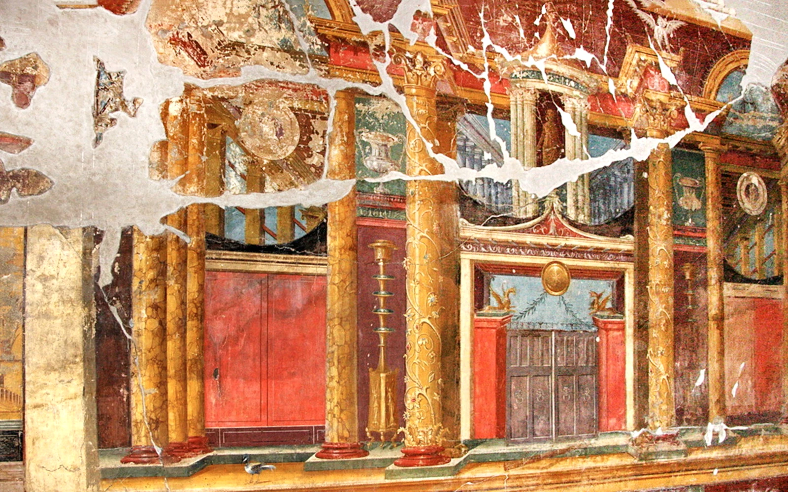
II. The Pinnacle of Ancient Mural Painting

The Villa of Oplontis contains what many art historians consider the finest, most extensive, and best-preserved cycle of Second and Third Style Roman wall paintings in existence.

  • The Illusion of Space: The artists employed advanced "Second Style" architectural illusionism. By painting complex, three-dimensional perspectives—featuring columns, balconies, and distant vistas—they visually "erased" the thick stone walls, effectively expanding the rooms into infinite, imagined worlds.

  • The Garden Room (Oecus): In the garden-facing halls, the frescoes are so precise that botanists have been able to identify the specific flora—including oleander, viburnum, and various fruits—that were planted not only in the frescoes but likely in the actual villa gardens.

  • Pigment and Technique: The murals feature an extravagant use of precious minerals, including cinnabar (mercury sulfide), a deep, vibrant red that was among the most expensive pigments in the ancient world. The use of such materials indicates that cost was no object, as the owner sought to create an environment that radiated prestige and cultural enlightenment.

III. Infrastructure and Engineering of Leisure

Beyond the aesthetic, the villa was a marvel of Roman hydraulic and thermal engineering.

  • The Great Swimming Pool: The central courtyard features a massive, rectangular open-air pool (approx. 60 by 17 meters). This was not merely a functional element; it was the visual and social heart of the villa. Surrounded by porticos and decorated with fountains and statues, it served as a stage for aristocratic life, where the elite could engage in the otium (leisure) activities—reading, philosophy, and conversation—that defined the Roman concept of a "good life."

  • Private Thermae: The villa housed a private bath complex, complete with a caldarium (hot room), tepidarium (warm room), and frigidarium (cold room). The use of hypocaust systems—underfloor heating powered by external furnaces—ensured that the villa remained climate-controlled year-round, allowing the owners to retreat to their seaside paradise regardless of the season.

  • Domestic Seclusion: The villa’s layout was meticulously planned to segregate the elite from the operational aspects of the estate. A complex network of kitchens, bakeries, and slave quarters was tucked away, ensuring that the labor required to sustain such luxury remained entirely invisible to the residents and their guests.

IV. A Snapshot of Abandonment

The eruption of Mount Vesuvius in 79 CE entombed the villa, but with a unique twist. Archaeologists have determined that at the time of the eruption, the villa was undergoing major structural renovations.

  • The "Empty" Estate: Because the villa was partially empty of furniture and household objects, researchers have a rare, unobstructed view of the Roman building techniques themselves. We can see the skeletal structure of the masonry, the application of various plaster layers, and the preparatory designs for the frescoes.

  • Biological Preservation: The thick blanket of volcanic ash preserved not just the stone, but the organic footprint of the villa. Excavations have revealed preserved carbonized wood from garden trellises and, most remarkably, the original planting soil, which has provided definitive data on how the Romans managed their topsoil to support such an immense garden-estate.

The Villa of Oplontis stands as a monument to the Roman aristocratic lifestyle—a world that was as visually spectacular as it was socially exclusionary. It captures a moment in time where nature, architecture, and art were perfectly synthesized to project the ultimate expression of imperial identity.

Ancient Greek Festivals: The Dionysia and the Birth of Drama

June 2, 2026

The City Dionysia (or Great Dionysia) was far more than a mere theatrical festival; it was a sophisticated, state-sponsored cultural centerpiece of Athenian democracy. Held annually in the spring (the month of Elaphebolion, roughly March/April), it functioned as a grand demonstration of Athens' religious piety, artistic supremacy, and political power.

I. The Birthplace of Drama

The festival is universally recognized as the crucible of Western drama. Its evolution from ritual to theater is a defining chapter in ancient history:

  • From Dithyrambs to Tragedy: The festival’s roots lay in the dithyramb—a choral ode sung and danced in honor of Dionysus, the god of wine, transformation, and fertility. Over time, the leader of the chorus (the choragus) began to engage in dialogue with the group, creating the prototype for the actor.

  • The First Thespian: Tradition credits the poet Thespis (c. 534 BCE) with the revolutionary innovation of introducing an actor who interacted with the chorus, effectively "inventing" acting. His name is the etymological root of "thespian."

  • Tragedy and Comedy: The festival matured into a highly structured competition featuring three genres:

    • Tragedy: Playwrights (like Aeschylus, Sophocles, and Euripides) presented a tetralogy consisting of three tragedies and one lighter satyr play, which provided a comedic, often ribald, counterpoint to the gravity of the tragedies.

    • Comedy: Comedic playwrights (like Aristophanes) competed in a separate category, using satire to critique contemporary politics, social norms, and public figures.

II. Festival Structure and Civic Duty

The City Dionysia was a massive undertaking that involved the entire city-state:

  • The Pompe (Procession): The festival began with a grand, vibrant procession that escorted a cult statue of Dionysus into the city and to his sanctuary, signaling the god's presence at the event.

  • State Sponsorship: Plays were not performed for profit but as a civic duty. Wealthy citizens, known as choregoi, were selected by the state to fund the training and costumes of the chorus. This was a form of "liturgy"—a mandatory tax-like service that conferred great social prestige on the donor.

  • The Competitive Spirit: Each year, three tragedians were chosen to compete. A jury of ten men, selected by lot from each of the ten Athenian tribes, judged the performances. The winning playwrights and their choregoi received immense public acclaim and were often immortalized in inscribed records.

III. Theater as a Political Stage

The Theatre of Dionysus, located on the southern slope of the Athenian Acropolis, was a purpose-built space designed to hold upwards of 14,000–17,000 spectators. It was intentionally constructed as a communal "seeing place" (theatron).

  • Athens’ Showcase: Because the festival took place in spring when sailing conditions improved, the city was filled with foreign dignitaries and representatives from across the Athenian Empire. Athens used the event as a public stage to display its wealth, present war orphans, and flaunt its cultural dominance.

  • Communal Experience: The open-air, hillside construction ensured that the entire citizenry—primarily male citizens—shared a collective experience. The performances were not merely entertainment; they were serious investigations into justice, the nature of the gods, the ethics of war, and the responsibilities of the citizen.

IV. Evolution of the Stage

The physical environment of the theater evolved in tandem with the drama:

  • The Orchestra: The circular "dancing place" remained the focal point for the chorus.

  • The Skene: Originally a simple tent for costume changes, it evolved into an elaborate stone structure with multiple levels and wings, allowing for complex stagecraft, including the use of cranes (mechane) for "deus ex machina" entrances and rolling platforms (ekkyklema) to reveal interior scenes.

The City Dionysia fundamentally transformed human storytelling. By turning the worship of Dionysus into a structured dialogue between a lone actor and a chorus, the Greeks created a medium where society could mirror itself, question its values, and explore the extremities of the human condition under the gaze of both the gods and the state.

The Mycenaean Warrior Vase: Depictions of Late Bronze Age Soldiers

June 2, 2026

The Warrior Vase (or Warrior Krater) is arguably the most famous piece of Mycenaean pottery ever recovered, functioning not merely as a decorative vessel for mixing wine and water, but as a primary historical document. Discovered within the house of the "Warrior Grave" on the Acropolis of Mycenae in 1870, this vessel—dating to the transition between the LH IIIB and LH IIIC periods (roughly 1200 BCE)—offers an unparalleled visual inventory of the military state during the final, tumultuous decades of the Bronze Age.

I. The Aesthetics of a Shifting Era

The vessel represents a radical departure from the sophisticated, flowing, and naturalistic style that defined earlier Mycenaean pottery. During the height of the Mycenaean palaces, artwork was often ethereal, focusing on marine life or abstract, fluid patterns. The Warrior Vase, by contrast, is characterized by a "Pictorial Style" that is rigid, repetitive, and deeply schematic.

The figures are arranged in a solemn, rhythmic procession. The artist was not interested in perspective or anatomical realism; instead, they sought to communicate functional efficiency. Every soldier is identical in stature, gait, and equipment, underscoring the shift toward mass, disciplined infantry as the primary pillar of late Mycenaean power. This is the visual language of a society that was increasingly defined by the exigencies of defense and conflict.

II. The Infantry Panoply: An Archaeological Inventory

The vase serves as a "battle guide" for the Late Bronze Age, detailing the specific kit required of a professional soldier. Because of its clarity, it has been used by experimental archaeologists to reconstruct the realities of Mycenaean combat:

  • The Headgear (Helmets): The soldiers wear distinct, high-crested helmets adorned with what appear to be horns or cheek pieces. Some scholars interpret these as hedgehog-style headgear, likely reinforced with layers of leather or perhaps even rows of small, trimmed boar's tusks—an evolution of the iconic boar's tusk helmet seen in earlier, more heroic-age depictions.

  • The Defensive Layer (Body Armor): Each figure wears a short, fringed tunic. Beneath this, there is strong evidence for a breastplate—likely constructed of hardened leather or layered linen—to provide protection against the thrusting spears that were the primary weapons of the time. The addition of greaves (shin guards) suggests that these soldiers were trained to move on foot through rough, mountainous terrain, rather than relying exclusively on the chariot as a platform for battle.

  • The "Crescent" Shield: This is perhaps the most significant tactical detail. Earlier Mycenaean iconography favored the massive, unwieldy "tower shield" or the "figure-of-eight" shield. The soldiers on the vase carry smaller, circular, or "crescent" shields. This smaller footprint indicates a strategic shift toward a mobile infantry capable of intricate maneuvering, likely necessitated by the need to combat agile raiders or to operate in close-quarters skirmishing.

  • The Logistics of the Spear: The long, leaf-shaped spears are depicted with small, rounded bundles dangling from the shafts. These have been interpreted by historians as ration sacks or field-packs containing essential supplies. This detail humanizes the army, signaling a transition from the "heroic" combat of singular champions to a professionalized force that could sustain itself on long-distance marches across the Peloponnese.

III. The Cultural Narrative: Farewell and Resolve

The presence of a female figure on the far left of the procession, shown with her hand raised toward her forehead in a gesture of mourning or farewell, introduces a poignant human dimension. It suggests that this was not merely a stylized glorification of war, but a reflection of the profound societal anxiety that characterized the end of the 13th century BCE.

This was a time of "The Great Migration" and the collapse of neighboring civilizations (the Sea Peoples, the decline of the Hittite Empire). The Warrior Vase reflects this climate; it is a depiction of a society girding itself for an existential threat. The woman represents the home front, watching the men depart for a war from which they might not return, reinforcing the connection between the palace, the household, and the defense of the state.

IV. Legacy and Tactical Evolution

The Warrior Vase marks the beginning of the "Dark Ages" artistic tradition, where the focus shifted from the elite, palace-based culture to the community of the village and the warrior class. The transition from the massive chariot-based warfare—where a few aristocratic heroes decided the fate of cities—to a standardized infantry force represents a democratization of violence.

The vase confirms that by 1200 BCE, the Mycenaeans had abandoned the outdated, heavy gear of the earlier age in favor of a nimble, well-equipped, and highly disciplined infantry. It is the visual record of a military system in its final, frantic attempt to survive the crumbling of the Bronze Age world.

Roman Mosaics in Britain: The Fishbourne Roman Palace

June 2, 2026

The Fishbourne Roman Palace, located near Chichester, West Sussex, represents perhaps the most significant window into the Romanization of Britain. Far from a mere provincial villa, this site is widely considered the largest residential structure of its kind north of the Alps, and its mosaic collection is a testament to the staggering wealth and political integration of the British client-kings within the broader Roman Empire.

I. Historical Context and Architectural Grandeur

Constructed around 75 CE, only a few decades after the initial Roman invasion of 43 CE, the palace serves as the ultimate symbol of the cultural shift in Britain. Most historians believe the palace was built for Tiberius Claudius Togidubnus, a local ruler who served as a loyal Roman ally. The sheer scale—covering roughly 10 acres—was designed to impress visitors and assert Roman authority, functioning as an administrative headquarters and a lavish royal residence that rivaled the architecture found in the heart of Rome itself.

The palace was structured in a sprawling, symmetrical "H" or quadrangle design centered around a massive formal garden. This garden, which has been meticulously reconstructed based on the original 1st-century planting trenches, is itself a marvel of Roman landscape architecture, incorporating sophisticated drainage and irrigation systems that allowed for imported Mediterranean plants to flourish in the British climate.

II. The Mosaics: A Masterclass in Opus Tessellatum

The mosaics at Fishbourne are globally renowned not only for their beauty but for their temporal sequence, allowing archaeologists to track the evolution of Roman decorative arts over several generations.

  • 1st-Century Geometric Sophistication: The earliest floors, dating to the initial construction period, utilize a more restrained, monochromatic palette. These feature complex geometric patterns such as "guilloche" (braided bands), "swastika-meanders," and "labyrinthine" designs. These patterns required immense mathematical precision to ensure that the small, hand-cut stone cubes—known as tesserae—aligned perfectly across vast areas of flooring.

  • The Cupid on a Dolphin: This is the most famous example of the palace’s figurative art. Located in the north wing, this polychromatic masterpiece depicts Cupid, the god of love, riding a dolphin through a sea of patterned waves. It is a classic "Mediterranean" motif, suggesting that the owner of the villa was well-versed in the cultural currents of the wider Empire and wished to broadcast his status as a sophisticated, Romanized elite.

  • Technical Artistry: The mosaics are prime examples of opus tessellatum. To create these floors, craftsmen first laid a foundation of rubble, concrete, and lime plaster. As the plaster began to harden, they pressed thousands of tiny colored stones into the surface. The variety of colors—deep reds, ochres, vibrant blues, and chalky whites—was achieved by sourcing limestone, marble, and terracotta from across the British Isles and, in some cases, importing materials from the Continent.

III. The Architecture of Luxury: Hypocausts and Preservation

The mosaics were not just aesthetic choices; they were part of a high-tech domestic environment. Beneath many of the floors lies an extensive hypocaust system. This underfloor heating technology involved supporting the floors on stacks of ceramic tiles (pilae) and circulating hot air from external furnaces through the space below.

  • Why they survived: The palace was abandoned in the 3rd century, likely due to a fire. Unlike other Roman sites that were stripped of their valuable materials (like roof tiles and marble columns) for use in medieval construction, Fishbourne was left to fall into ruin and was gradually buried by silt and earth. This deep burial protected the mosaics from the elements and human scavengers for nearly 1,700 years until their accidental discovery by a construction crew in 1960.

  • Modern Preservation: Today, the mosaics are protected by a permanent conservation building that maintains a constant humidity and temperature. This is essential, as the ancient mortar—which has been exposed to the air for only a few decades—is incredibly fragile compared to the surrounding stone.

IV. Cultural Significance: "Power Dressing" in Architecture

The Fishbourne mosaics represent a deliberate act of "Power Dressing" on a monumental scale. By commissioning such expensive, complex, and quintessentially Roman floors, the residents were making a political statement. They were signaling that Britain was no longer a distant, "barbarian" periphery of the Empire, but a fully integrated province where Roman identity, luxury, and artistic mastery were the new standard.

The palace remains an unparalleled archaeological resource because it captures a moment of total cultural transformation. Every pattern and tile tells a story of an elite class desperate to prove their loyalty to Rome by mimicking the domestic life of the Roman aristocracy in Italy.

Ancient Greek Shipwrecks: The Kyrenia Ship and the Wine Trade

June 2, 2026

The Kyrenia Ship, a Hellenistic merchant vessel that sank off the coast of Cyprus around 285–272 BCE, stands as one of the most important archaeological discoveries for understanding the ancient Mediterranean trade economy. Discovered by diver Andreas Cariolou in 1965 and excavated by Michael and Susan Katzev from 1968 to 1969, the ship provides a remarkably well-preserved snapshot of maritime commerce during the era of Alexander the Great’s successors.

I. The "Amphora Trade"

The ship’s primary cargo consisted of approximately 380–400 transport amphorae. These jars were the "shipping containers" of the ancient world, and their presence on the Kyrenia ship maps an extensive trade network:

  • Regional Origins: The majority of the amphorae originated from the island of Rhodes, with others sourced from ports across the Eastern Mediterranean, including Samos, Kos, Knidos, Cyprus, and even as far as Palestine and Egypt.

  • Commodities: While many of the jars were found empty, archaeological analysis identified residues and contents such as wine, olive oil, and almonds. The presence of over 10,000 intact almonds suggests that the ship was likely participating in a diverse "bulk" trade, carrying various agricultural surpluses between major ports.

II. Beyond the Wine: A Diverse Cargo

The Kyrenia ship was not just a wine transporter; it functioned as a general-purpose freighter. Other notable items recovered from the hold include:

  • Ballast and Tools: The ship carried 27–29 stone grain millstones stacked in three rows over the keel, serving the dual purpose of ballast and valuable trade goods.

  • Industrial Goods: Archaeologists found iron billets (blooms), which were raw materials for blacksmiths.

  • Daily Life and Rigging: Excavations uncovered lead fishing net weights, cooking pots, ladles, and dining sets (black-glazed plates and cups). The distribution of these items in two distinct "cabin" areas (fore and aft) led researchers to conclude the ship likely carried a small, four-man crew who lived and worked on board for extended voyages.

III. Technological Significance

The ship’s construction itself is a treasure trove of nautical history:

  • Lead Sheathing: The vessel’s outer hull was covered in thin lead sheets affixed with copper tacks. This is the earliest known instance of using "hull armor" to protect wood from shipworms and marine borers—a clear sign that the ship was a high-value asset intended for long-term use.

  • "Shell-First" Construction: It was built using the ancient carvel method, where the outer hull planking was assembled before the internal ribs were inserted.

  • The "Piracy" Theory: Despite early theories of natural sinking, the discovery of bent iron spearheads embedded in the ship’s timber and the notable absence of personal valuables (other than a few coins) suggest the vessel may have been hunted down and sunk by pirates, a common threat to merchant ships of the period.

The Kyrenia ship remains a testament to the sophistication of Hellenistic maritime logistics, revealing a highly connected world where commodities like wine, grain, and nuts were moved across vast distances by specialized vessels built to withstand the rigors of the open sea.

Ancient Egyptian Queens: The Powerful Reign of Nefertiti

June 2, 2026

Nefertiti remains one of the most enigmatic and influential figures in ancient Egyptian history. As the Great Royal Wife of Pharaoh Akhenaten during the 18th Dynasty (c. 1353–1336 BCE), she was not merely a consort but a central force in one of the most radical religious and political upheavals in the ancient world.

The Amarna Period: A Religious Revolution

Nefertiti’s reign is inseparable from the Amarna Period, a time when her husband, Akhenaten, dismantled the traditional polytheistic Egyptian religion in favor of Atenism—the monotheistic or henotheistic worship of the sun disk, the Aten.

  • Active Participation: Unlike traditional queens who were often depicted in a secondary, domestic role, Nefertiti was portrayed as an active partner. She frequently appears in relief scenes alongside Akhenaten, performing religious rites, offering to the Aten, and even smiting Egypt’s enemies—a prerogative historically reserved exclusively for the Pharaoh.

  • Ideological Partner: Scholars often describe her as Akhenaten's "ideological muse." Her name, Neferneferuaten-Nefertiti ("The Beautiful are the Beauties of Aten, the Beautiful One Has Come"), explicitly linked her identity to the new state religion. She served as a high priestess and a primary intermediary between the people and the god.

  • Artistic Innovation: The Amarna period introduced a distinctive artistic style characterized by more expressive, naturalistic, and even androgynous forms. Nefertiti’s imagery, including the famous portrait bust found in the workshop of the sculptor Thutmose, redefined the standard of beauty and royal authority.

Power and Possible Co-Regency

There is significant scholarly debate regarding the extent of Nefertiti's political authority. Many historians now believe she exercised power far beyond that of a typical queen consort.

  • Co-Ruler Theory: Several pieces of evidence suggest Nefertiti may have been a co-regent. She is depicted wearing pharaonic crowns and performing duties typically associated with the king, suggesting she was seen as a legal and divine equal.

  • The "Female Pharaoh" Hypothesis: Her disappearance from the records after the 12th year of Akhenaten's reign has led some to speculate that she did not simply die or fall from grace. A prominent theory is that she adopted the throne name Neferneferuaten and ruled either as a co-regent during the final years of Akhenaten’s life or as a sole female pharaoh after his death, just before the ascension of Tutankhamun.

The Mystery of Her Origin and End

Much of Nefertiti’s life remains veiled in mystery, partly because her legacy was systematically targeted by later pharaohs who sought to restore the old religious order and erase the memory of the "heretic" Amarna kings.

  • Origins: Her parentage is not recorded. While early theories suggested she might be a foreign princess (such as the Mitanni princess Tadukhipa), many modern scholars point to circumstantial evidence suggesting she was the daughter of the courtier Ay, who would later become Pharaoh himself.

  • Disappearance: Her "disappearance" from the historical record remains a major topic of study. While some believe she died during a plague or a time of internal turmoil, recent epigraphic discoveries, such as a graffito at Deir el-Bersha dating to the 16th year of Akhenaten’s reign, confirm that she was still alive and active late in his life, supporting the theory that she continued to wield power long after the initial years of their reign.

Nefertiti is ultimately remembered as a "powerbroker" who transcended the traditional limitations of her gender in a male-dominated society. Whether or not she ruled as a sole monarch, she was undeniably the female pillar upon which the most controversial reign in Egyptian history was built.

The Viking Graves of Kaupang: Norway’s First Urban Center

June 2, 2026

Kaupang, located near present-day Larvik in Vestfold, Norway, is widely recognized as Norway's first proto-urban settlement and a pivotal marketplace of the Viking Age. Established around 800 CE and active until the mid-10th century, it served as a vital hub for trade, craft production, and cultural exchange.

Kaupang as an Urban Center

Unlike the predominantly rural farmsteads typical of the era, Kaupang functioned as a dense, permanent center of economic activity. At its peak, it supported an estimated population of 400 to 1,000 inhabitants. Its strategic position along the Viksfjorden allowed it to connect inland Norwegian resources with broader maritime trade networks reaching the North Sea, the Baltic, the British Isles, and even the Islamic world. Archaeological evidence—including a planned layout of plots, harbor facilities, and workshops—highlights its role as an organized "market-place" (the literal meaning of the Old Norse word kaupangr).

Discoveries in the Grave Sites

The cemeteries surrounding the settlement have been a primary focus of archaeological interest for over 150 years, yielding over 100,000 artifacts that offer a window into the lives of its residents:

  • Diverse Grave Types: Excavations have revealed cremation cemeteries, burial mounds, and boat burials. Some of the more elaborate boat burials are thought to have belonged to wealthy merchants, possibly of Danish origin.

  • International Goods: The grave goods provide clear evidence of Kaupang’s far-reaching trade networks. Finds include:

    • Luxury Items: Islamic silver coins, gold jewelry, and glass beads from various parts of Europe.

    • Craft and Daily Life: Tools for metalworking, weapons, and soapstone objects, which were common in both household contexts and burials.

    • Foreign Imports: Ceramic objects from Denmark, Frankish and Anglo-Saxon book mounts, Irish jewelry, and Rhenish pottery used for serving German wine.

  • Cultural Melting Pot: The mix of burial styles and the wide range of imported goods suggest that Kaupang was a cosmopolitan crossroads where local craftsmen and farmers lived and worked alongside merchants from across Scandinavia and beyond.

The site’s abandonment around 950 CE is thought to be the result of a combination of factors, including shifting trade routes, changing political landscapes, and the gradual silting of the harbor, which eventually led to the rise of new trade centers like Tønsberg. Today, the area is preserved as a cultural heritage site, where ongoing research and public exhibitions continue to illuminate this foundational chapter in Norwegian urban history.

Kaupang: The Viking Capital City

This video is relevant because it provides an overview of Kaupang's history as an early urban site, summarizing its significance as a trading hub and the archaeological insights gained from the area.

The Roman Legionary’s Life: Pay, Punishment, and Retirement

June 2, 2026

The life of a Roman legionary was structured with a level of bureaucratic and military precision that was unprecedented in the ancient world. It was a rigorous, 25-year contract that transformed a civilian into a professional instrument of the State. To understand the depth of this commitment, one must look at the intersection of economic incentive, institutional fear, and the promise of a future as a landowning citizen.

I. The Economics of the Legion: More Than Just a Salary

A legionary’s financial life was governed by a sophisticated system that functioned much like a modern banking account.

  • The Stipendium and Deductions: While 225 to 300 denarii annually might seem modest, it provided stability in an otherwise volatile economy. However, the State was a shrewd landlord. The fiscus (the military treasury) deducted costs for the essentials of life in the field:

    • Frumentum (Rations): The cost of grain provided to the soldiers.

    • Vestitus (Clothing): Replacements for tunics, cloaks, and leather footwear.

    • Armatura (Arms & Armor): Costs for maintaining gladii, pilum, and lorica segmentata.

    • The Burial Club: Soldiers paid into a community fund to ensure they received a proper burial—a necessity in a world where an unattended corpse was considered a profound religious and social tragedy.

  • The Signifer as Banker: Since soldiers had no place to spend large amounts of cash while on campaign, the signifer (standard-bearer) of their century acted as an informal but strictly regulated banker. He held the soldiers' savings, paying interest and providing a sense of financial security that encouraged long-term service.

  • Donativa and Booty: A soldier’s real wealth was often made on the frontiers. Successful military campaigns resulted in the sale of prisoners and goods, with shares distributed by rank. Furthermore, the donativum—a massive cash bonus given by an Emperor upon his accession—served to solidify the army's political loyalty during sensitive transitions of power.

II. The Culture of Discipline: Fear as the Ultimate Anchor

The Roman military operated on the principle that the internal threat (the soldier’s own failure) was as dangerous as the external one. Discipline was maintained through a dual system of immediate, localized correction and extreme, public sanction.

  • The Centurion’s Vitis: The Centurion was the ultimate arbiter of daily discipline. His authority was signaled by the vitis, a vine staff. While it served as a symbol of his office, it was frequently used to administer instant corporal punishment—flogging or beating a soldier who failed to march in step, neglected his equipment, or showed signs of insubordination.

  • The Fustuarium (Clubbing): Reserved for offenses that threatened the safety of the unit (such as sleeping on watch or stealing), this was a communal execution. The culprit was stripped, and his fellow soldiers were required to beat him to death with clubs. This forced the unit to participate in the enforcement of discipline, ensuring that no individual felt empowered to break the rules at the expense of his peers.

  • Decimation: While rare, this was the nuclear option. If a unit fled in battle, they could be divided into groups of ten. Lots were drawn, and the "lucky" man who drew the shortest straw was executed by his nine companions. It was a brutal psychological tool designed to make the fear of one's own unit greater than the fear of the enemy.

III. The Praemium: The "Golden Handcuffs" of Retirement

The transition to a professional, long-term army was solidified by the creation of the aerarium militare by Augustus. This pension fund removed the reliance on generals to provide land for their troops—a practice that had historically caused the devastating civil wars of the late Republic.

  • The 25-Year Threshold: The service was grueling. Upon completion of 20 years of active duty and 5 years in the reserves (evocati), a soldier was granted an honesta missio (honorable discharge).

  • The Pension: The payout—roughly 12,000 sesterces—was enough to purchase a small farm in a colonia (a veterans' settlement). This turned former soldiers into a conservative, stable class of landowners who were personally invested in the continued peace and prosperity of the Empire.

  • Citizenship as Social Currency: Perhaps the most profound benefit was for those in the auxilia. Auxiliaries were often recruited from non-citizen tribes. After 25 years, the soldier, his wife, and his children were granted full Roman citizenship. This effectively turned the military into an engine of Romanization, pulling entire families out of "barbarian" status and into the Roman legal and social fold.

This system created a powerful feedback loop: soldiers were well-paid and well-pensioned to ensure loyalty, and they were disciplined with such extreme severity that they remained perfectly focused on their duties. The legionary was, in effect, a cog in a machine that offered him more social and economic security than he could have ever hoped to achieve as a simple civilian.

Ancient Greek Temples: The Temple of Hephaestus in Athens

June 2, 2026

The Temple of Hephaestus, often called the Hephaisteion or historically the Theseion, stands as the most intact example of a Doric temple from Classical antiquity. Perched atop the Kolonos Agoraios hill on the northwest edge of the Ancient Agora, it offers a rare, near-complete view of 5th-century BCE Athenian religious architecture.

Architectural Mastery and Design

Constructed between approximately 449 and 415 BCE, the temple was designed by the same anonymous architect who worked on the Parthenon. Despite its smaller scale, it mirrors the Parthenon’s aesthetic grandeur and structural precision.

  • Doric Peripteral Plan: The structure is a classic "peripteral" temple, meaning it is surrounded by a continuous colonnade. It features a hexastyle layout—six columns on the front and back facades, and thirteen columns along the sides.

  • Materiality: Built primarily from luminous Pentelic marble—the same material used for the Parthenon—the temple possesses a natural resistance to weathering, which has significantly contributed to its survival.

  • Structural Features: It is unique for being the only temple of its period in Athens to retain its original roof. The internal layout includes the pronaos (entrance portico), the cella (or naos, the main chamber housing the cult statues), and the opisthodomos (the rear compartment).

  • Artistic Decoration: The exterior is adorned with metopes and friezes. While the front metopes depict the labors of Heracles and the legends of Theseus, the interior frieze illustrates the mythical battle between the Centaurs and the Lapiths.

Dedication and Symbolism

The temple was dedicated to Hephaestus, the god of fire, metalworking, and craftsmanship, and Athena Ergane, the patroness of pottery and the arts.

Its location was deeply intentional. The Agora was the industrial hub of Athens, and the temple overlooked the Street of the Marble Workers and numerous bronze and iron foundries. By placing the temple here, the Athenians honored the craftsmen who powered the city's economy and built its monuments, elevating the status of manual labor within the civic landscape.

A Legacy of Survival

The temple’s exceptional preservation is not merely a result of its sturdy materials, but of its continuous use:

  1. Christian Conversion: In the 7th century CE, the temple was repurposed as the Christian Church of Saint George (Agios Georgios Akamates). This transition protected the building from the systematic dismantling and quarrying that destroyed many other civic structures in the Agora during Late Antiquity and the Byzantine era.

  2. A Living Monument: As a functioning church, it remained well-maintained for over a millennium. It served this religious role until 1833, when the last liturgy was held.

  3. Modern Status: After Greek independence, it was briefly converted into a museum before becoming a dedicated archaeological site in 1934.

Because it was never abandoned, its original roof, colonnades, and decorative friezes were spared the environmental and human-led destruction that claimed so many other monuments of the Classical world.

Would you be interested in learning more about the metopes specifically, or perhaps how other ancient structures in the Agora compare to this well-preserved site?The Temple of Hephaestus, often called the Hephaisteion or historically the Theseion, stands as the most intact example of a Doric temple from Classical antiquity. Perched atop the Kolonos Agoraios hill on the northwest edge of the Ancient Agora, it offers a rare, near-complete view of 5th-century BCE Athenian religious architecture.

Architectural Mastery and Design

Constructed between approximately 449 and 415 BCE, the temple was designed by the same anonymous architect who worked on the Parthenon. Despite its smaller scale, it mirrors the Parthenon’s aesthetic grandeur and structural precision.

  • Doric Peripteral Plan: The structure is a classic "peripteral" temple, meaning it is surrounded by a continuous colonnade. It features a hexastyle layout—six columns on the front and back facades, and thirteen columns along the sides.

  • Materiality: Built primarily from luminous Pentelic marble—the same material used for the Parthenon—the temple possesses a natural resistance to weathering, which has significantly contributed to its survival.

  • Structural Features: It is unique for being the only temple of its period in Athens to retain its original roof. The internal layout includes the pronaos (entrance portico), the cella (or naos, the main chamber housing the cult statues), and the opisthodomos (the rear compartment).

  • Artistic Decoration: The exterior is adorned with metopes and friezes. While the front metopes depict the labors of Heracles and the legends of Theseus, the interior frieze illustrates the mythical battle between the Centaurs and the Lapiths.

Dedication and Symbolism

The temple was dedicated to Hephaestus, the god of fire, metalworking, and craftsmanship, and Athena Ergane, the patroness of pottery and the arts.

Its location was deeply intentional. The Agora was the industrial hub of Athens, and the temple overlooked the Street of the Marble Workers and numerous bronze and iron foundries. By placing the temple here, the Athenians honored the craftsmen who powered the city's economy and built its monuments, elevating the status of manual labor within the civic landscape.

A Legacy of Survival

The temple’s exceptional preservation is not merely a result of its sturdy materials, but of its continuous use:

  1. Christian Conversion: In the 7th century CE, the temple was repurposed as the Christian Church of Saint George (Agios Georgios Akamates). This transition protected the building from the systematic dismantling and quarrying that destroyed many other civic structures in the Agora during Late Antiquity and the Byzantine era.

  2. A Living Monument: As a functioning church, it remained well-maintained for over a millennium. It served this religious role until 1833, when the last liturgy was held.

  3. Modern Status: After Greek independence, it was briefly converted into a museum before becoming a dedicated archaeological site in 1934.

Because it was never abandoned, its original roof, colonnades, and decorative friezes were spared the environmental and human-led destruction that claimed so many other monuments of the Classical world.

The Minoan Peak Sanctuaries: Rituals on the Cretan Mountains

June 2, 2026

Minoan peak sanctuaries were distinctive open-air religious sites established on the summits or prominent ridges of mountains across Crete during the Bronze Age (roughly 2100–1400 BCE). They represent a core aspect of Minoan spirituality, serving as a focal point for communal interaction with the divine and the natural landscape.

Characteristics and Purpose

These sites were intentionally located to dominate the local landscape, offering panoramic views of both the sky and the surrounding valleys, settlements, and grazing lands.

  • Communal Worship: Scholars believe these sites began as popular shrines used by peasants and shepherds to petition the gods for agricultural success, protection of livestock, and healing.

  • Ritual Offerings: Excavations consistently reveal large deposits of votive offerings, including:

    • Clay Figurines: Representations of human worshippers in gestures of adoration, as well as animals like wild goats, cattle, and bulls.

    • Anatomical Votives: Clay models of limbs, eyes, and other body parts, which are believed to be requests for healing or bodily restoration.

  • Evidence of Ritual: Many sites contain evidence of bonfires (ash layers), altars, and small architectural structures. At sites like Anemospilia on Mount Juktas, archaeologists found more complex temple-like structures, suggesting intense, organized rituals.

Evolution and Centralization

The role of these sanctuaries shifted as Minoan society became more centralized around palace centers like Knossos.

  • Protopalatial Heyday: During the Protopalatial period (c. 1900–1700 BCE), there was a dense, widespread network of these sanctuaries across the island.

  • Neopalatial Centralization: In the Neopalatial period (c. 1700–1400 BCE), the number of active sanctuaries declined significantly, with only about eight major sites remaining. These surviving sanctuaries—most notably Mount Juktas—became much wealthier, featuring high-quality votive objects (such as inscribed libation tables and bronze double-axes). This suggests that the ruling elites had appropriated these sites to exert ideological and religious control over the rural population.

Significance

  • The Sacred Landscape: The sanctuaries were likely viewed as "liminal" spaces—places where the divine could be accessed more directly. Their intervisibility (the ability to see one sanctuary from another) created a "network of sacred beacons" that may have served both as ritual infrastructure and as a means of communication or territorial signaling.

  • Symbolic Power: By the Neopalatial period, the imagery of the "Mountain Mother" (a goddess often depicted on mountain peaks) became a powerful symbol of authority, linking the sanctity of the mountains to the power of the palace and the ruler.

In essence, these sanctuaries evolved from grassroots responses to the concerns of rural life into formal, state-sponsored landmarks that legitimized the power of the Minoan elite while grounding the civilization's religion in the rugged Cretan landscape.

The Viking Colonization of the Faroe Islands

May 31, 2026

The Viking colonization of the Faroe Islands—long considered a straightforward story of 9th-century Norse migration—has been fundamentally reshaped by recent archaeological and genetic research. We now understand the settlement of these islands to be a complex, multi-phase process that began centuries before the arrival of the famous Viking longships.

The Myth of the First Settlers

It was traditionally believed that the Faroe Islands were uninhabited until the arrival of Norse Vikings, possibly preceded by a brief presence of Irish hermits (the papar) in the 7th and 8th centuries. However, modern science has challenged this narrative:

  • Pre-Viking Evidence: Radiocarbon dating of peat ash and barley grains has confirmed human activity as early as the 4th–6th centuries CE, and again in the 6th–8th centuries.

  • Genetic and Biological Traces: DNA analysis of sheep bones found in sediment layers dates to as early as 500 CE, suggesting that these pre-Viking settlers—likely Celtic or Gaelic in origin—were already practicing animal husbandry on the islands long before the Norse arrived.

  • Toponymy: The Faroese landscape retains linguistic "fossil" evidence of this earlier population. Place names containing the element "ergi" (derived from the Gaelic airge, meaning a summer pasture or shieling) indicate that Gaelic speakers were active in the islands’ agricultural life before the Norse took full control.

The Norse Transformation (9th Century CE)

While they were not the first, the Vikings did orchestrate the most significant demographic and cultural shift in the islands' history. Starting around 800–850 CE, a wave of settlers from western Norway established a more permanent, state-like society.

  • The Færeyinga Saga: This 13th-century Icelandic text identifies Grímur Kamban as the first permanent Norse settler. While often viewed as semi-legendary, his arrival aligns with the archaeological evidence of a rapid increase in permanent Norse farmsteads during the 9th century.

  • State Formation: The Vikings introduced their traditional social and legal structures, most notably the Løgting (Parliament) in Tórshavn. Established around 825 CE, it remains one of the world’s oldest parliamentary institutions, demonstrating the Viking focus on structured governance and law.

Daily Life and Archaeological Findings

Excavations at sites like Kvívík and Toftanes have provided a vivid picture of the Viking-age economy, which blended traditional Norse methods with the unique demands of the North Atlantic environment:

  • Architecture: Viking farmsteads typically consisted of longhouses built with thick walls of stone and turf—an adaptation to the islands' lack of timber. These houses often included an attached byre (cowshed) to protect livestock through harsh winters.

  • Material Culture: Findings such as spindles, cod-liver oil lamps, and fishing gear reveal an economy heavily reliant on maritime resources. Interestingly, archaeologists have found items like imported slate millstones and even a woman's shoe of a style found in contemporary Paris, proving that these "isolated" settlers were part of a sophisticated, wide-reaching trade network.

  • Children and Recreation: Excavations have recovered wooden toys, including miniature ships and horses, as well as chess pieces, suggesting that Faroese Viking life allowed for leisure and community connection.

Legacy and Cultural Identity

The Viking influence proved resilient, primarily because it was built on a foundation of communal sustainability:

  • Language: The Faroese language remains one of the closest modern living languages to Old Norse, having evolved in relative isolation and resisted total assimilation by Danish or other mainland influences.

  • Ritual Landscape: Place names in areas like Suðuroy, such as Hov ("temple") and Hørg ("sacrificial mound"), still mark the sites of pagan ritual centers that predate the islands' conversion to Christianity around the year 1000 CE.

  • Enduring Traditions: Cultural markers like the chain dance (kvæði), performed to epic ballads, are considered a rare, living link to the medieval period, having survived precisely because the islands' remote geography shielded them from the religious and social prohibitions that eradicated similar traditions elsewhere in Europe.

The settlement of the Faroe Islands was not a single event, but a layering of cultures. The Vikings "re-colonized" a landscape already touched by earlier settlers, ultimately fusing their own political and social structures with the existing agricultural practices to create the distinct Faroese identity that persists today.

Since you are interested in the evolution of these societies, would you like to compare how the Viking settlement of the Faroe Islands differed from their approach to colonizing the more challenging environments of Iceland or Greenland?

Ancient Egyptian Pharaohs: The Reign of the Heretic King Akhenaten

May 31, 2026

The reign of Akhenaten (c. 1353–1336 BCE) stands as the most disruptive and enigmatic period of the Egyptian New Kingdom. By abandoning the traditional pantheon in favor of the sole worship of the sun-disk, the Aten, Akhenaten triggered a social, political, and religious revolution that nearly dismantled the established order of the Egyptian state.

The Religious Revolution

  • Atonism: Akhenaten declared the Aten—the physical disk of the sun—to be the only god. This was not merely a shift in worship; it was an act of extreme centralization. All previous deities, including the powerful Amun-Ra, were stripped of their influence, and their temples were forcibly closed.

  • Divine Intermediary: In traditional Egyptian religion, priests acted as intermediaries between the gods and the people. Akhenaten abolished this hierarchy, asserting that he and his queen, Nefertiti, were the only individuals capable of communicating directly with the Aten. This effectively consolidated all religious, political, and economic power into the hands of the Pharaoh.

  • The Sun Temple Architecture: Departing from the dark, labyrinthine sanctuary design of traditional temples, the temples of the Aten were open-air structures built to maximize exposure to sunlight. This architectural change symbolized the "open" nature of the new faith, where the light of the sun could directly touch the king and his subjects.

The Move to Amarna (Akhetaten)

  • A New Capital: Akhenaten abandoned Thebes, the traditional religious capital, and founded a brand-new city in the desert: Akhetaten (modern-day Amarna). Built at an unprecedented speed, the city was designed to be the earthly seat of the Aten.

  • Geopolitical Isolation: Excavations at Amarna have revealed that while the city was a hub for the royal court, it was largely cut off from the traditional power centers of the empire. This isolation allowed Akhenaten to pursue his radical social experiments without the interference of the powerful Theban priesthood.

  • The Amarna Letters: Archives found at the site contain the "Amarna Letters," a collection of diplomatic correspondence written on clay tablets. These letters offer a rare, unfiltered look at the decay of Egyptian foreign policy during his reign, showing that while Akhenaten was preoccupied with his religious vision, Egypt’s influence over its vassal states in the Levant began to falter.

The Amarna Style: A Radical Artistic Shift

  • The "Deformed" Ideal: Artistic representations from this period represent a dramatic departure from the rigid, idealized conventions of Egyptian art. Akhenaten is depicted with a long face, heavy eyelids, narrow shoulders, a protruding belly, and wide hips.

  • Humanizing the Divine: Historians debate whether these features were symbolic or a literal representation of a medical condition (such as Marfan syndrome or Froehlich’s syndrome). Regardless of the intent, the art became more informal and intimate, often depicting the royal family in candid, affectionate moments—a sharp contrast to the detached, stoic portrayals of earlier Pharaohs.

  • Naturalism: The "Amarna Style" emphasized naturalism, flowing lines, and a sense of movement. This artistic rebellion was a visual reinforcement of his religious rebellion, stripping away the old aesthetics that were tethered to the traditional gods.

The Reaction: Damnatio Memoriae

  • The Restoration: After Akhenaten’s death, the establishment—led by his successors Tutankhamun, Ay, and eventually the military general Horemheb—moved quickly to restore the old order. Amarna was abandoned and systematically dismantled.

  • Erasing the Heretic: The subsequent dynasties engaged in a massive damnatio memoriae (condemnation of memory). Akhenaten’s name was hacked out of monuments, his temples were torn down to fill the foundations of later buildings, and his reign was officially classified as a period of chaos and divine displeasure.

  • Archaeological Paradox: Ironically, the systematic destruction of Amarna by later kings is exactly what allowed the city to be so well-preserved for modern archaeologists. Because the city was abandoned so suddenly and subsequently left untouched by later urban development, it provides a "time capsule" of domestic and administrative life during the 18th Dynasty that is unmatched in Egyptology.

Historical Significance

Akhenaten remains a polarizing figure. To some, he is a visionary monotheist and a champion of individual spiritual connection; to others, he is a dangerous autocrat whose obsession with a single dogma nearly ruined the prosperity of the New Kingdom. Ultimately, his reign serves as a stark warning about the fragility of state power when it becomes untethered from tradition and focuses entirely on the whims of a single, absolute ruler.

Given your interest in historical sites and engineering, would you like to delve deeper into the specific construction techniques used for the rapid, mud-brick build of Akhetaten, or perhaps the subsequent "Restoration Stela" left by Tutankhamun?

The Roman Catacombs of Paris: The Underground Ossuary

May 31, 2026

The Paris Catacombs (or the Ossuaire Municipal) represent one of the most unique archaeological and historical sites in Europe. While often associated with the macabre, the site is a complex engineering solution to a major 18th-century public health crisis, evolving from abandoned quarry tunnels into a structured, memorialized resting place for millions of Parisians.

The Engineering of the Underground

  • Quarry Foundations: Before they were burial sites, these tunnels were limestone quarries that provided the stone used to build much of medieval and Renaissance Paris. By the 1700s, this subterranean network had become dangerously unstable, leading to city-wide collapses that threatened the foundations of buildings above.

  • The Consolidation Project: Under the direction of King Louis XVI, the Inspection générale des carrières (General Inspectorate of Quarries) was formed. Engineers spent decades shoring up the crumbling tunnels with massive pillars, dry-stone walls, and structural reinforcements, creating the vast, safe network of tunnels that exist today.

  • Microclimate and Preservation: The deep underground environment maintains a constant temperature and high humidity, which has proven remarkably effective at preserving the skeletal remains for centuries, preventing the decay that would occur in more exposed environments.

The Public Health Crisis

  • The Overflowing Cemeteries: In the 18th century, Paris’s inner-city cemeteries—most notably Les Innocents—were drastically overcapacity. Bodies were being buried in shallow pits for centuries, leading to severe sanitation issues, contamination of groundwater, and pervasive public health concerns that became impossible for the state to ignore.

  • The Great Relocation: In 1785, the government ordered the evacuation of Les Innocents. The bones were exhumed, blessed by priests, and transported by night in solemn, horse-drawn processions to the abandoned, consolidated quarry tunnels. This process continued for decades, moving the remains of an estimated 6 to 7 million people from various shuttered churchyards throughout the city.

Architecture and Memorialization

  • The Ossuary Style: The catacombs are not merely chaotic piles of bone. The remains were carefully arranged into a structured "ossuary" style. Femurs and tibias were stacked to form decorative walls, with skulls arranged in neat, mosaic-like rows or patterns, transforming the remains into a collective monument rather than a simple graveyard.

  • Reflective Epigraphs: Scattered throughout the tunnels are stone tablets and inscriptions featuring quotes from classical philosophers and poets. These were placed to provide a meditative, solemn atmosphere, shifting the focus from the horror of death to the philosophical contemplation of mortality and the history of Paris.

  • The "Lamps" of the Dead: To facilitate the movement of inspectors and authorized visitors, specific oil lamps were strategically placed. This early lighting infrastructure highlights the duality of the space: it was a place of the dead, yet it required constant maintenance, mapping, and monitoring by the living.

Archaeological and Historical Value

  • A "Historical" Archive: The catacombs serve as an unintentional but invaluable archive of the city’s population. The remains have been used by modern forensic scientists and historians to study diet, disease, and migration patterns across centuries of Parisian life, effectively providing a demographic record of the city’s development.

  • Geological Record: The walls themselves provide an exposed look at the geological history of the Paris Basin, revealing the distinct limestone layers that once defined the regional landscape and the economic prosperity of the medieval city.

  • Symbol of Civic Order: The transition from a chaotic, hazardous burial system to the organized, state-managed ossuary serves as an example of the Enlightenment-era drive to apply rational, bureaucratic, and scientific oversight to the most fundamental aspects of human society.

The Paris Catacombs stand as a poignant bridge between the city’s industrial past and its collective memory. They transformed an environmental liability—unstable quarries and failing cemeteries—into a subterranean monument that honors the anonymous citizens who built the foundations of modern Paris.

Since you are interested in historical infrastructure and archaeological enigmas, would you like to explore the Roman-era history of Paris (Lutetia) that exists beneath the modern city streets?

Ancient Greek Science: The Tunnel of Eupalinos on Samos

May 31, 2026

The Tunnel of Eupalinos, located on the Greek island of Samos, is widely considered one of the greatest feats of ancient engineering. Constructed in the 6th century BCE under the tyrant Polycrates, this 1,036-meter-long aqueduct served as a secure water supply for the ancient capital, demonstrating a level of mathematical precision that was centuries ahead of its time.

Engineering Mastery

  • The Problem of Measurement: The tunnel had to pass through Mount Kastro, a rugged and steep ridge. To ensure a consistent, slight gradient for gravity-fed water flow, the engineers had to tunnel from both sides of the mountain simultaneously and meet in the middle with near-perfect accuracy.

  • The Eupalinos Method: The architect, Eupalinos of Megara, utilized sophisticated geometric calculations. By using a series of right-angled triangles to track their progress, the two tunneling teams were able to align their headings despite the lack of modern surveying equipment.

  • Precision Alignment: When the two teams finally broke through, the vertical error was less than 4 meters, and the lateral error was less than 6 meters—a staggering achievement for a project completed around 530 BCE.

  • Gravity and Flow: The tunnel is not perfectly straight. Eupalinos deliberately utilized a slight, controlled descent to ensure that the water moved through the mountain at a constant, steady pace without overflowing the stone pipes or eroding the tunnel walls.

Architectural Features

  • The Conduit: The main tunnel is approximately 1.7 meters wide and 1.7 meters high, but beneath its floor lies a deeper, secondary trench. This trench held the terracotta pipes that carried the water, allowing the tunnel above to serve as both a maintenance walkway and an escape route in times of siege.

  • Safety and Maintenance: The tunnel was equipped with ventilation shafts and side chambers, ensuring that laborers could work safely and that the water supply could be inspected or cleared of blockages if necessary.

  • Hidden Strength: Because the aqueduct was built entirely underground, it was immune to enemy sabotage—unlike surface-level pipelines that could easily be cut. This made Samos one of the most resilient cities in the Aegean, as it could withstand long sieges without compromising its essential water supply.

Archaeological and Scientific Significance

  • Transition in Thought: The tunnel is a physical monument to the rise of rational, empirical science. It marks the transition from purely mythological or "trial and error" construction to a system of engineering based on mathematical theory and deductive reasoning.

  • Herodotus's Account: The Greek historian Herodotus documented the tunnel in his Histories, marking it as one of the three most important works of art and engineering in the Greek world. His account confirms that the ancients recognized this project not just as a utilitarian necessity, but as a triumph of the human intellect.

  • The "Calculated" Landscape: Archaeological investigations show that the tunnel was part of a larger, integrated water management system, including catchment basins and cisterns. This confirms that the builders possessed a holistic understanding of the local hydrology, planning the infrastructure based on long-term climatic cycles.

  • A Lesson in Durability: The tunnel remains in remarkable condition today, providing modern researchers with a clear view of how ancient engineers prioritized longevity. Its continued stability—even after millennia of seismic activity—is a testament to the sophisticated understanding of structural load and geological stress that defined the Ionian scientific tradition.

The Tunnel of Eupalinos is more than just a water pipe; it is a profound testament to the birth of the scientific method. It proves that the same intellectual culture that produced the philosophical inquiries of the Milesian School also applied those exact standards of logic, measurement, and deduction to reshape the natural world.

The Mycenaean Citadels: The Cyclopean Walls of Argos

May 31, 2026

The Cyclopean walls of the Mycenaean world are perhaps the most visually intimidating architectural legacy of the Greek Bronze Age. Named by later Greeks who believed such massive stones could only have been moved by the mythical one-eyed giants, these fortifications defined the power of the Mycenaean citadels, including the strategic strongholds around Argos.

Engineering of the Cyclopean Style

  • The Boulder Technique: The "Cyclopean" designation refers to the use of enormous, roughly hewn limestone boulders, some weighing several tons. These were stacked without mortar, with the gaps between the massive rocks filled with smaller stones and clay to create a cohesive, impenetrable barrier.

  • Mass and Stability: The structural philosophy was based entirely on mass. By using such heavy materials, the walls were effectively immovable. They were designed not just to stop infantry, but to withstand the psychological and physical force of a prolonged siege.

  • The Terracing Effect: At sites near Argos and Tiryns, the walls were often built into the natural slope of the hill. This created a terraced defensive system where each level of the wall provided a higher ground advantage, forcing attackers to navigate a gauntlet of uphill terrain while exposed to projectiles from the defenders above.

Strategic Purpose in the Argolid

  • Territorial Dominance: The citadels near Argos were part of a sophisticated, interconnected defense network. These fortresses were positioned to control the fertile plains of the Argolid and the vital coastal routes, acting as both secure storehouses for agricultural wealth and military garrisons.

  • Power Projection: The sheer scale of the walls served as a form of "architectural propaganda." For the local population and visiting emissaries, the sight of stones that appeared impossible for humans to lift was a direct reminder of the king’s ability to command vast amounts of labor and his divine or heroic connection to the legendary past.

  • The "Secret" Infrastructure: Archaeological surveys have revealed that these citadels were not just empty walls; they housed hidden postern gates and long, subterranean passages leading to external water sources. This ensured that, even when under siege, the citadel could remain self-sufficient.

Archaeological Context near Argos

  • The Tiryns-Argos Connection: While Mycenae is the most famous, the fortification systems around Argos—specifically at Tiryns and the Larissa of Argos—display the same massive masonry techniques. The citadel at Tiryns is especially notable for its "gallery" system: vaulted internal corridors built directly into the thickness of the walls, used for storage or as sheltered barracks for soldiers.

  • Evolution of Defense: Excavations suggest that these walls were not static. Over the centuries, the Mycenaeans repeatedly expanded their fortifications, thickening the walls and adding new bastions as the political climate grew more volatile, reflecting an era of increasing warfare leading up to the Late Bronze Age collapse.

  • Post-Mycenaean Survival: The durability of these walls allowed them to remain standing long after the Mycenaean palaces themselves were destroyed. In later centuries, the ruins of these citadels were often incorporated into classical Greek defenses, as the foundations were already so solid that subsequent generations found it easier to build on top of them than to try and tear them down.

Why They Endure

  • Seismic Resilience: Because the walls were built with a degree of "flex" between the heavy, unmortared stones, they were remarkably effective at absorbing seismic energy. Many of the walls that survived the collapse of the Bronze Age did so because they were inherently earthquake-resistant compared to the rigid, brick-and-mortar structures found elsewhere in the Mediterranean.

  • Human Labor as Currency: The construction of these walls required a level of social organization—the ability to organize, feed, and manage thousands of laborers—that provides modern archaeologists with clear evidence of a powerful, centralized state bureaucracy that controlled the Argolid during the peak of the Mycenaean era.

Roman Imperial Coins: The Propaganda of the Twelve Caesars

May 31, 2026

Roman imperial coinage functioned as the most effective mass-communication network in the ancient world. Before the invention of the printing press, coins were the primary mechanism for the government to project its image, enforce its ideology, and broadcast the legitimacy of its rulers across a vast, heterogeneous empire.

The Mechanism of Propaganda

  • The Medium: Every time a new emperor took the throne, coins were minted and distributed to every corner of the empire. For the average citizen, a coin was the only way they would ever see the face of their ruler.

  • The Message: Coinage transformed the person of the emperor into an institution. The obverse (front) usually featured a portrait of the ruler, while the reverse (back) showcased carefully curated messages, such as scenes of military victories, depictions of traditional gods, or slogans emphasizing stability and prosperity.

  • Economic Legitimacy: The consistent quality of the metal (the "fineness" of the silver or gold) served as a direct indicator of the health of the state. If an emperor decreased the silver content, he risked public distrust; conversely, maintaining currency standards was presented as proof of an emperor's integrity and economic mastery.

The Twelve Caesars: A Timeline of Ideology

The "Twelve Caesars" (as recorded by Suetonius) defined the visual language of the Roman Empire:

  • Julius Caesar: He was the first Roman to place his own portrait on a living coin, a radical break from Republican tradition that signaled the end of the old political order and the dawn of absolute rule.

  • Augustus: His coinage solidified the imperial image. He favored a youthful, idealized portrait style, associating himself with Apollo and the return of a "Golden Age." His coins broadcasted the message of Pax Romana—the peace that only the emperor could provide.

  • Tiberius: His coins introduced the "Tribute Penny" type, which became central to the empire’s standardized taxation and military payment systems. His portraiture grew more somber, projecting an image of the stoic, serious ruler.

  • Caligula: His coinage was used to re-establish his family connection to Augustus, emphasizing his lineage as a key source of his authority, even as his reign descended into erratic behavior.

  • Claudius: His coins highlighted the conquest of Britain, using the imagery of the "arch of triumph" to emphasize his role as a successful commander who expanded the boundaries of the empire.

  • Nero: His coinage evolved from traditional portraiture to more complex propaganda, often featuring the emperor playing the lyre or engaging in cultural activities, aimed at framing him as a patron of the arts and a populist leader.

  • Galba, Otho, and Vitellius: The "Year of the Four Emperors" proved the importance of coinage as a tool of war. Each claimant rushed to mint coins to pay their legions and announce their legitimacy, with their faces appearing and disappearing from the currency within months, highlighting the instability of the period.

  • Vespasian: He initiated a massive overhaul of the currency system to restore confidence after the civil wars of 69 CE. His coins focused on "Roma" and "Victoria," projecting an image of the empire as a stable, indestructible entity.

  • Titus: His coinage frequently commemorated the completion of the Colosseum and his victories in the Judean Wars, linking his reign to the grandeur of Rome’s architectural and military achievements.

  • Domitian: His coins displayed an increasingly autocratic tone, with titles like Dominus et Deus (Lord and God) appearing on the inscriptions, demonstrating the shift toward absolute, divinely sanctioned rule.

Archaeological Significance

  • Chronological Markers: Because coins bear the name and often the titles of the reigning emperor, they are the single most useful tool for archaeologists to date layers of strata at excavation sites.

  • Economic Distribution: The discovery of coin hoards throughout Britain, Gaul, and the Near East maps the movement of troops, the growth of trade routes, and the economic integration of the provinces.

  • The History of Lost Coins: Large hoards—like the Worcestershire coin hoard or recent finds in the UK—frequently offer a "snapshot" of historical crises. When people bury their wealth in the ground, it is rarely during times of peace; it is a physical indicator of the very moments that Roman propaganda sought to hide—civil unrest, invasion, and economic collapse.

The coins of the Twelve Caesars were not just currency; they were the "social media" of the ancient world. They turned the shifting politics of Rome into a visual language that every subject, from a merchant in the East to a legionary on the Rhine, could understand and internalize.

The Viking Age Fortifications: The Danevirke and the Shield of Denmark

May 31, 2026

The Danevirke (or Dannevirke) stands as one of the most ambitious defensive achievements of the Viking Age. Located in present-day northern Germany, it served as a monumental earthen and timber barrier—the "Shield of Denmark"—designed to protect the fledgling Danish kingdom from Frankish, Saxon, and later Holy Roman Empire expansion.

Strategic Architecture and Construction

  • The Barrier System: Rather than a single line of defense, the Danevirke was a complex, multi-phased system of ramparts, ditches, and walls that stretched across the narrow neck of the Jutland Peninsula. It spanned roughly 30 kilometers, effectively sealing off the land route between the Baltic Sea and the North Sea.

  • Earthwork Engineering: The early phases (starting in the 7th century) consisted of massive earthen ramparts topped with wooden palisades. Over time, as military threats evolved, these were expanded with stone facings and brick reinforcements, reflecting a transition from tribal warfare to state-level military architecture.

  • The Curtius Wall: A hallmark of the system is the "Curtius Wall," a sophisticated brick fortification added in later phases. This showcased the Danes' ability to adopt continental European masonry techniques to enhance their native defensive strategies.

  • The Gateway (Wiglesdör): The fortifications included highly controlled gateways, most notably the Wiglesdör, which channeled all trade and military movement. This served as a "chokepoint," allowing the Danish kings to monitor traffic, collect tolls, and project power over the vital trade routes between the mainland and the Scandinavian world.

The Role of the Shield of Denmark

  • Boundary of Power: The Danevirke was more than a fence; it was a political statement. It demarcated the southern frontier of the Danish sphere of influence, creating a clear "us versus them" boundary against the encroaching Carolingian Empire.

  • Defensive Resilience: The fortification allowed the Danes to withstand repeated attempts by Frankish rulers to subjugate the North. By funneling invaders into narrow kill-zones or preventing rapid cavalry movement, the Danevirke negated the tactical advantages of the heavier, armor-clad armies of the south.

  • Integration with Waterways: The defensive line was strategically designed to integrate with the Schlei inlet and the Eider River. By linking land barriers with natural water obstacles, the Vikings created an "impenetrable" perimeter that required coordinated naval and land assaults to overcome.

Archaeological Significance and Evolution

  • Dendrochronological Dating: Thanks to the preservation of timber in the waterlogged soil, researchers have used dendrochronology to date different phases of the construction with year-to-year precision. This has proven that the Danevirke was not built at once, but was a dynamic project updated by successive rulers, including the famous King Godfred and Queen Thyra.

  • A Dynastic Monument: Excavations suggest that the fortification was intimately tied to the consolidation of the Danish monarchy. Building such a massive structure required a centralized tax system, a standing labor force, and the ability to mobilize the entire population—the definitive archaeological markers of a true "state."

  • The Legacy of Conflict: The site continued to be used for military purposes into the 19th century. Its survival as a visible landscape feature makes it one of the few places in Europe where one can physically trace the evolution of defensive strategy from the Early Medieval period through the modern era.

By defending the land route, the Danevirke allowed the Viking centers of power—like the trade hub of Hedeby—to flourish. It remains the physical embodiment of the Viking Age’s transition from sea-based raiding to the defense of a defined, sovereign territory.

Ancient Egyptian Farming: The Calendar of the Three Seasons

May 31, 2026

Ancient Egyptian agricultural life was governed by a rigorous, three-season calendar dictated entirely by the annual inundation of the Nile. This cycle was so predictable and essential that it structured the entire Egyptian state, economy, and religious belief system.

The Three Seasons

  • Akhet (Inundation / Flood): Lasting roughly from mid-July to mid-November, this season began when the star Sirius rose in the predawn sky, signaling the start of the Nile’s flood. The river overflowed its banks, depositing nutrient-rich black silt (kemet) across the valley floor. During this time, direct farming was impossible, and the labor force was redirected to state projects, such as building temples and pyramids.

  • Peret (Emergence / Growth): Spanning mid-November to mid-March, this was the primary planting and growing season. As the floodwaters receded, the silt-covered soil was moist and easy to plow. Farmers used wooden plows pulled by oxen to sow wheat, barley, and flax. This was a critical period for managing irrigation canals and dikes to ensure the receding water reached all fields.

  • Shemu (Harvest / Drought): From mid-March to mid-July, the heat intensified and the Nile reached its lowest levels. This was the most labor-intensive season, involving the harvesting of crops, threshing, and winnowing. It was also the period of the "harvest tax," where state scribes measured the grain yields to determine taxation, often tied to the level of the previous year's flood.

Engineering and Irrigation Technology

  • Basin Irrigation: Egyptians mastered a natural flood-management system. They created a grid of earthen banks or dikes that divided the land into basins. When the Nile flooded, these basins would trap the silt-laden water, allowing it to soak deep into the soil and deposit its fertilizing sediment.

  • The Shaduf: Introduced during the New Kingdom, this was a simple but revolutionary mechanical device consisting of a long pole with a weight on one end and a bucket on the other. It allowed farmers to lift water from the Nile or irrigation canals into higher channels, effectively extending the growing season and allowing for the irrigation of land that the natural flood could not reach.

  • Canal Management: A centralized bureaucracy was responsible for the maintenance of a vast network of canals. The state’s ability to coordinate the dredging and clearing of these canals was a primary indicator of political stability; a breakdown in canal management meant crop failure and famine.

Societal and Economic Impact

  • The Scribe’s Role: Because the economy was based on grain, scribes were the backbone of the agricultural system. They maintained "Nilometers"—stone structures built into the riverbanks to measure the height of the flood. By predicting the flood’s intensity, the state could forecast harvest yields, adjust tax burdens, and plan for potential food shortages.

  • Crop Specialization:

    • Emmer Wheat & Barley: These were the staples of the Egyptian diet, used to produce the bread and beer that sustained the entire population.

    • Flax: Essential for the production of linen, which was the primary material for clothing and essential for the mummification process.

    • Papyrus: Cultivated in marshy areas, it provided the vital medium for Egyptian record-keeping and literature.

  • Theological Connection: The cycle of the Nile was a divine reflection of the journey of the gods. The death of the land during Shemu and its rebirth during Akhet mirrored the myth of Osiris, who was associated with fertility, the afterlife, and the resurrection of vegetation. Farming was not merely economic survival; it was a religious act that participated in the maintenance of Ma'at (universal order).

The Roman Bridge of Alcantara: 1,900 Years of Service

May 31, 2026

The Bridge of Alcántara, spanning the Tagus River in Spain, is perhaps the most enduring monument to Roman civil engineering. Completed in 106 CE during the reign of Emperor Trajan, it stands as a structural masterclass that has survived nearly two millennia of floods, warfare, and heavy transit, remaining essentially intact to this day.

Engineering and Architectural Features

  • Dry-Stone Precision: Like the arena of Nîmes, the bridge was constructed using massive granite blocks fitted together without the use of mortar. This gravity-defying accuracy allowed the structure to withstand the natural expansion and contraction caused by the extreme temperature fluctuations of the Spanish plateau.

  • Load Distribution: The bridge consists of six central arches that support a total length of 194 meters. These arches are of unequal height and width, a deliberate design choice that allowed the builders to anchor the bridge into the solid bedrock of the riverbank, ensuring maximum stability against the force of the river’s currents.

  • The Triumphal Arch: At the center of the bridge stands a dedicated triumphal arch, a powerful symbol of Roman authority. It served as a gateway for the Via Norbensis, the imperial road that linked the region of Lusitania to the rest of the empire, signaling to all travelers that they were under the protection and law of Rome.

  • Foundation Integrity: The bridge's piers were built directly into the riverbed on massive, deep-set foundations. This involved sophisticated underwater engineering, likely using cofferdams—watertight enclosures that were pumped dry—to allow the stonemasons to work on the bedrock, a technique that demonstrates the Roman mastery of hydraulics.

Historical Context and Strategic Value

  • Imperial Infrastructure: The bridge was not merely a convenience; it was a critical component of a wider imperial strategy to integrate the Iberian Peninsula. By facilitating the rapid movement of legions, government officials, and trade goods, it cemented the economic and political stability of the Roman provinces.

  • Symbolic Continuity: The Latin inscription on the bridge declares that it was "built to last forever" (perpetui mansuram in saecula). This was a deliberate piece of architectural propaganda, emphasizing the eternity and immutability of the Roman state, a claim that 1,900 years of survival have largely validated.

  • Resilience through Conflict: The bridge’s survival is all the more impressive given its strategic importance. Throughout the Middle Ages and into the early 19th century, it was frequently targeted during conflicts, including the Reconquista and the Peninsular War. While the central and end arches were occasionally blown up or damaged to impede military advancement, they were always repaired using the original Roman techniques, maintaining the structural integrity of the entire crossing.

Archaeological and Cultural Legacy

  • A Living Monument: Unlike ruins that are fenced off and preserved as "static" history, the Bridge of Alcántara served as an active vehicular crossing well into the 20th century. Its transition from an imperial transit artery to a heritage site highlights the bridge's role as a continuous thread in the history of the region.

  • The "Trajanic" Style: The bridge is a prime example of the architectural classicism that flourished under Trajan, a period characterized by a return to monumentality, precision, and the use of enduring stone materials. It reflects the peak of Roman ability to reshape the natural landscape to serve human expansion.

  • Engineering Model: Today, the bridge remains a site of intense study for civil engineers and archaeologists alike. It serves as a benchmark for structural longevity, offering a clear view of how Roman planners prioritized durability, site-specific design, and the use of local natural resources to create architecture capable of defying the passage of time.

Ancient Egyptian Boats: The Solar Barque of Khufu

May 28, 2026

The Khufu ship, also known as the Solar Barque, is a pinnacle of ancient maritime engineering and one of the most significant archaeological finds in Egyptology. Discovered in 1954 buried in a sealed pit at the foot of the Great Pyramid of Giza, this intact funerary boat dates to approximately 2500 BCE and provides a unique window into the ship-building expertise of the Fourth Dynasty.

Engineering and Construction

  • Material and Precision: The ship is constructed entirely from Lebanese cedar, a high-value imported timber. The craftsmanship is extraordinary; the cedar planks were joined using a "mortise and tenon" system, where wooden pegs were inserted into slots to lock the planks together without the use of nails or metal fasteners.

  • Seaworthiness: Unlike many ritual models, the Khufu ship was a fully functional, ocean-going vessel. It measures 43.6 meters long and 5.9 meters wide. Its design features a flat bottom and a curved hull, optimized for navigating the shallow but swift currents of the Nile.

  • Lashing System: The structural integrity of the ship was reinforced by heavy ropes made of papyrus fiber. These ropes were threaded through loops carved directly into the hull timbers, serving as a "tensioning" system that allowed the boat to remain flexible and resilient when encountering water resistance.

  • Oar and Steering: The vessel was equipped with ten oars—five on each side—for propulsion. For navigation, it utilized a pair of massive steering oars at the stern, demonstrating a sophisticated understanding of hydrodynamics and balance.

Symbolic and Ritual Function

  • The Solar Context: The term "Solar Barque" reflects the ship’s religious significance. In Egyptian mythology, the sun god Ra traversed the heavens by day in a solar boat and navigated the dangerous depths of the underworld by night. By interring this vessel beside his pyramid, Khufu was ensuring his own ability to accompany the god on this eternal journey.

  • The "Khufu" Connection: Archaeologists believe the ship served a genuine funerary purpose—perhaps transporting the King’s embalmed body from Memphis to Giza, or serving as a ritual vessel for the deceased monarch’s transition to the afterlife. The presence of wood-staining and wear on the ropes indicates that the ship had been used on the water before its final interment.

  • Elite Provisioning: The burial of such a massive, expensive, and labor-intensive object at the base of the Great Pyramid served as a final, monumental assertion of the Pharaoh’s status. It was a tangible investment in the King’s divinity, meant to endure for eternity alongside the pyramid itself.

Archaeology and Preservation

  • The Discovery: The ship was found dismantled into 1,224 individual pieces, tightly packed inside a pit covered by massive limestone slabs weighing up to 20 tons each. The airtight seal of the pit protected the organic material from decay for over 4,500 years.

  • Reconstruction: The reassembly of the vessel took years of meticulous study and trial-and-error. The challenge was compounded by the fact that the ancient Egyptians left no blueprints or written instructions on how to put the puzzle back together.

  • Modern Relocation: In 2021, the ship was moved from its original discovery site to the Grand Egyptian Museum (GEM) in Giza. This monumental move involved a specialized, shock-absorbent container, ensuring that one of the oldest surviving wooden vessels in the world remains intact for future generations.

Historical Legacy

  • Maritime Evolution: The ship remains a primary source for understanding how the Egyptians built the massive vessels required to transport granite blocks from Aswan to the Giza plateau.

  • Symbol of Continuity: Its construction and burial reflect the absolute centralization of the Egyptian state during the Old Kingdom. The ability to source timber from Lebanon, organize skilled labor, and dedicate such resources to a single burial ritual demonstrates the sophisticated bureaucratic and economic machine that characterized the era of the Great Pyramids.

← Newer Posts Older Posts →
Featured
image_2026-06-02_134555446.png
June 4, 2026
Roman Mosaics in Spain: The Roman Villa of La Olmeda
June 4, 2026
Read more →
June 4, 2026
image_2026-06-02_134512415.png
June 4, 2026
The Viking Age Silver Economy: Hacksilver and Islamic Dirhams
June 4, 2026
Read more →
June 4, 2026
image_2026-06-02_134427249.png
June 4, 2026
Ancient Egyptian Writing: Hieroglyphs, Hieratic, and Demotic
June 4, 2026
Read more →
June 4, 2026
image_2026-06-02_134351192.png
June 4, 2026
The Roman Arch of Titus: The Spoils of the Jerusalem Temple
June 4, 2026
Read more →
June 4, 2026
image_2026-06-02_134313891.png
June 4, 2026
Ancient Greek Sanctuaries: The Cave of Zeus on Mount Ida
June 4, 2026
Read more →
June 4, 2026
image_2026-06-02_134212891.png
June 4, 2026
The Minoan Pottery Styles: Kamares Ware and Marine Style
June 4, 2026
Read more →
June 4, 2026
read more

Powered by The archaeologist