The Viking Age permanently reshaped the geopolitical landscape of the British Isles, transforming fragmented Anglo-Saxon kingdoms into a dynamic zone of Scandinavian colonization, trade, and cultural synthesis. While Norse raiders originally targeted isolated monasteries for quick plunder, by the late 9th century, their strategy shifted toward permanent territorial conquest.
The crown jewel of this Scandinavian expansion was the Viking Kingdom of York (known to the Norse as Jórvík). Established in 866 CE by the Great Heathen Army, this urban enclave evolved from a conquered Anglo-Saxon capital into an international mercantile powerhouse, bridging the economies of the North Sea with the deep interiors of the European continent.
1. The Fall of Eoforwic: The Dawn of Jórvík
Before the arrival of the Scandinavians, the city was known as Eoforwic, the capital of the Anglo-Saxon Kingdom of Northumbria. It was an important ecclesiastical center, home to a grand minster and a prosperous trading settlement.
In November 866 CE, the Great Heathen Army, led by the legendary Viking chieftains Ivar the Boneless and Halfdan Ragnarsson, launched a brilliant tactical assault on the city. They capitalized on a bitter civil war dividing the Northumbrian elite.
The Vikings easily breached the city's aging, neglected Roman stone walls on All Saints' Day. When the rival Northumbrian kings united the following spring to retake the city, the Vikings trapped them inside the fortifications, slaughtering both kings and decisively dismantling Anglo-Saxon rule in the north.
Rather than burning the city to the ground, Halfdan partitioned the surrounding Northumbrian lands among his veteran warriors in 876 CE. They laid down their swords, picked up plows, and established a permanent Scandinavian royal dynasty centered at York.
2. Urban Infrastructure and the Coppergate Discoveries
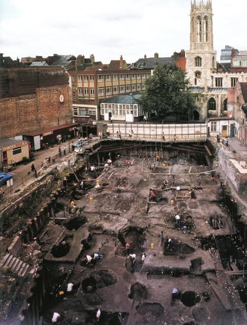
For over a thousand years, our understanding of Viking York was limited to hostile Anglo-Saxon monastic chronicles that painted the Norse inhabitants as dirty, illiterate raiders. This historical bias was shattered between 1976 and 1981 by the monumental excavations conducted by the York Archaeological Trust at the Coppergate site.
Because the waterlogged, oxygen-free soil along the River Foss perfectly preserved organic materials, archaeologists uncovered an intact, highly sophisticated 10th-century Viking neighborhood.
The Architecture of the Wattle and Daub
The Coppergate excavations revealed that Jórvík was a dense, bustling metropolis laid out along a highly structured grid system. The streets were lined with long, narrow plots packed with timber-framed tenement buildings:
The Materials: Houses were built using oak posts with walls made of interwoven hazel branches (wattle) packed with a mixture of clay, straw, and animal dung (daub). Some later structures featured sunken, semi-subterranean cellars designed to maximize storage space.
The Layout: Each building functioned as a combined family home, retail storefront, and industrial workshop. Fireplaces cut into the dirt floors provided heat and light, while the roofs were thatched with local reeds or straw.
3. An International Mercantile Powerhouse
The Coppergate discoveries proved that Jórvík was not a primitive fortress, but one of the premier international trade hubs of Western Europe. The city's geographic position—situated at the confluence of the rivers Ouse and Foss—allowed deep-sea Viking longships to sail directly from the North Sea into the heart of the city.
The workshops of York hummed with specialized mass production, manufacturing goods that were exported across the global Viking trade network:
Metalworking and Coinage: York operated its own highly active mint. Viking kings, despite being pagan, quickly adapted to the local monetary economy, striking millions of silver coins that featured a fascinating blend of Christian crosses and pagan symbols, such as the hammer of Thor.
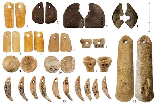
Textiles and Leatherwork: Scholars discovered thousands of discarded leather shoes, sophisticated bone skates, and wooden textiles, proving the existence of highly organized cobbler and weaving guilds.
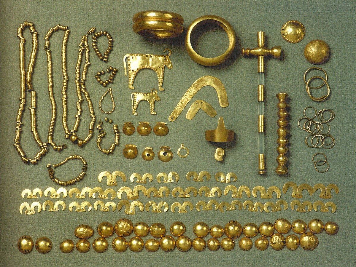
The Global Import Network: The soil of Coppergate yielded exotic items that traveled thousands of miles across the Viking world. Archaeologists recovered silk from the Byzantine Empire, amber from the Baltic Sea, walrus ivory from Greenland, cowrie shells from the Indian Ocean, and jet jewelry from nearby Whitby.
4. The Geopolitical Seesaw: The Dublin-York Axis
The political history of the Kingdom of York was exceptionally volatile, characterized by a constant, violent tug-of-war between Norse kings, Anglo-Saxon monarchs trying to unify England, and rival Celtic kingdoms.
The most fascinating political dynamic was the Dublin-York Axis. In the early 10th century, a powerful Viking dynasty known as the Uí Ímair (the House of Ivar) ruled simultaneously over the Viking Kingdom of Dublin in Ireland and the Kingdom of York in England.
  [ VIKING DUBLIN ] ◄─────── (The Uí Ímair Dynasty) ───────► [ VIKING YORK ]
         │                                                           │
   (Irish Sea Trade)                                          (North Sea Trade)
         └───────────────────────────┬───────────────────────────────┘
                                     ▼
                    [ Anglo-Saxon Military Resistance ]
                        (Kings Athelstan & Eadred)
Viking warlords like Ragnall ua Ímair and Sitric Cáech marched armies across the Pennine mountains, attempting to unify the Irish Sea and North Sea trade networks into a single, massive Scandinavian empire.
This Norse ambition faced fierce resistance from the expanding Anglo-Saxon Kingdom of Wessex. In 927 CE, the West Saxon King Athelstan launched a lightning invasion, captured York, and received the submission of the Northumbrians, effectively uniting England under an Anglo-Saxon crown for the very first time. However, the moment Athelstan died, the Norsemen of Dublin immediately sailed back across the sea to reclaim their York throne.
5. The End of an Era: Eric Bloodaxe
The final chapter of independent Viking York was written by one of the most infamous characters of the Viking Age: Eric Bloodaxe (Eiríkr Blóðöx), the deposed King of Norway.
Eric was invited by the fiercely independent Northumbrian nobility to rule York in 947 CE, serving as a powerful military buffer against the southern Anglo-Saxon kings. His reign was a chaotic period of shifting alliances, betrayals, and urban warfare.
In 954 CE, facing an overwhelming invasion threat from the West Saxon King Eadred, the people of York finally expelled Eric Bloodaxe to save their city from destruction. Shortly after leaving the city, Eric was ambushed and killed at the desolate mountain pass of Stainmore. With his death, the independent independent Viking Kingdom of York dissolved permanently, and the city was fully integrated into the unified Kingdom of England.
6. Summary of Settlement Dynamics
The Conquest (866 CE): Launched by the Great Heathen Army under Ivar the Boneless, capitalizing on Northumbrian instability to convert an Anglo-Saxon ecclesiastical center into a Scandinavian royal seat.
Urban Form: Densely populated, highly organized wattle-and-daub tenement neighborhoods (evidenced by the Coppergate excavations) functioning as active live-work craft spaces.
Economic Footprint: An international trade powerhouse operating a sovereign silver mint, importing luxury goods from Byzantium and the Baltic while exporting specialized mass-produced tools, textiles, and leatherwork.
The Collapse (954 CE): Decades of geopolitical swinging along the Dublin-York Axis concluded when the city expelled its final Norse king, Eric Bloodaxe, permanently consolidating York into the medieval Kingdom of England.
The legacy of Viking Jórvík is woven directly into the physical and cultural fabric of modern York. While independent Norse rule ended in 954 CE, the Scandinavians did not leave. They intermarried with the local Anglo-Saxon population, creating a unique Anglo-Scandinavian dialect and culture.
Every time a modern visitor walks down streets ending in the Norse suffix "-gate" (derived from the Old Norse gata, meaning street)—such as Coppergate, Stonegate, or Walmgate—or looks at the deeply layered archaeological horizons beneath the city's foundations, they are stepping directly into the footprint of an era when Viking longships transformed a provincial English town into a bustling center of global trade.
Would you like to explore the unique layout of the Anglo-Scandinavian legal system, the Danelaw, which governed this region, or look closer into the specific diets and parasites discovered by bioarchaeologists analyzing the CoppergaThe Viking Age permanently reshaped the geopolitical landscape of the British Isles, transforming fragmented Anglo-Saxon kingdoms into a dynamic zone of Scandinavian colonization, trade, and cultural synthesis. While Norse raiders originally targeted isolated monasteries for quick plunder, by the late 9th century, their strategy shifted toward permanent territorial conquest.
The crown jewel of this Scandinavian expansion was the Viking Kingdom of York (known to the Norse as Jórvík). Established in 866 CE by the Great Heathen Army, this urban enclave evolved from a conquered Anglo-Saxon capital into an international mercantile powerhouse, bridging the economies of the North Sea with the deep interiors of the European continent.
1. The Fall of Eoforwic: The Dawn of Jórvík
Before the arrival of the Scandinavians, the city was known as Eoforwic, the capital of the Anglo-Saxon Kingdom of Northumbria. It was an important ecclesiastical center, home to a grand minster and a prosperous trading settlement.
In November 866 CE, the Great Heathen Army, led by the legendary Viking chieftains Ivar the Boneless and Halfdan Ragnarsson, launched a brilliant tactical assault on the city. They capitalized on a bitter civil war dividing the Northumbrian elite.
The Vikings easily breached the city's aging, neglected Roman stone walls on All Saints' Day. When the rival Northumbrian kings united the following spring to retake the city, the Vikings trapped them inside the fortifications, slaughtering both kings and decisively dismantling Anglo-Saxon rule in the north.
Rather than burning the city to the ground, Halfdan partitioned the surrounding Northumbrian lands among his veteran warriors in 876 CE. They laid down their swords, picked up plows, and established a permanent Scandinavian royal dynasty centered at York.
2. Urban Infrastructure and the Coppergate Discoveries
For over a thousand years, our understanding of Viking York was limited to hostile Anglo-Saxon monastic chronicles that painted the Norse inhabitants as dirty, illiterate raiders. This historical bias was shattered between 1976 and 1981 by the monumental excavations conducted by the York Archaeological Trust at the Coppergate site.
Because the waterlogged, oxygen-free soil along the River Foss perfectly preserved organic materials, archaeologists uncovered an intact, highly sophisticated 10th-century Viking neighborhood.
The Architecture of the Wattle and Daub
The Coppergate excavations revealed that Jórvík was a dense, bustling metropolis laid out along a highly structured grid system. The streets were lined with long, narrow plots packed with timber-framed tenement buildings:
The Materials: Houses were built using oak posts with walls made of interwoven hazel branches (wattle) packed with a mixture of clay, straw, and animal dung (daub). Some later structures featured sunken, semi-subterranean cellars designed to maximize storage space.
The Layout: Each building functioned as a combined family home, retail storefront, and industrial workshop. Fireplaces cut into the dirt floors provided heat and light, while the roofs were thatched with local reeds or straw.
3. An International Mercantile Powerhouse
The Coppergate discoveries proved that Jórvík was not a primitive fortress, but one of the premier international trade hubs of Western Europe. The city's geographic position—situated at the confluence of the rivers Ouse and Foss—allowed deep-sea Viking longships to sail directly from the North Sea into the heart of the city.
The workshops of York hummed with specialized mass production, manufacturing goods that were exported across the global Viking trade network:
Metalworking and Coinage: York operated its own highly active mint. Viking kings, despite being pagan, quickly adapted to the local monetary economy, striking millions of silver coins that featured a fascinating blend of Christian crosses and pagan symbols, such as the hammer of Thor.
Textiles and Leatherwork: Scholars discovered thousands of discarded leather shoes, sophisticated bone skates, and wooden textiles, proving the existence of highly organized cobbler and weaving guilds.
The Global Import Network: The soil of Coppergate yielded exotic items that traveled thousands of miles across the Viking world. Archaeologists recovered silk from the Byzantine Empire, amber from the Baltic Sea, walrus ivory from Greenland, cowrie shells from the Indian Ocean, and jet jewelry from nearby Whitby.
4. The Geopolitical Seesaw: The Dublin-York Axis
The political history of the Kingdom of York was exceptionally volatile, characterized by a constant, violent tug-of-war between Norse kings, Anglo-Saxon monarchs trying to unify England, and rival Celtic kingdoms.
The most fascinating political dynamic was the Dublin-York Axis. In the early 10th century, a powerful Viking dynasty known as the Uí Ímair (the House of Ivar) ruled simultaneously over the Viking Kingdom of Dublin in Ireland and the Kingdom of York in England.
  [ VIKING DUBLIN ] ◄─────── (The Uí Ímair Dynasty) ───────► [ VIKING YORK ]
         │                                                           │
   (Irish Sea Trade)                                          (North Sea Trade)
         └───────────────────────────┬───────────────────────────────┘
                                     ▼
                    [ Anglo-Saxon Military Resistance ]
                        (Kings Athelstan & Eadred)
Viking warlords like Ragnall ua Ímair and Sitric Cáech marched armies across the Pennine mountains, attempting to unify the Irish Sea and North Sea trade networks into a single, massive Scandinavian empire.
This Norse ambition faced fierce resistance from the expanding Anglo-Saxon Kingdom of Wessex. In 927 CE, the West Saxon King Athelstan launched a lightning invasion, captured York, and received the submission of the Northumbrians, effectively uniting England under an Anglo-Saxon crown for the very first time. However, the moment Athelstan died, the Norsemen of Dublin immediately sailed back across the sea to reclaim their York throne.
5. The End of an Era: Eric Bloodaxe
The final chapter of independent Viking York was written by one of the most infamous characters of the Viking Age: Eric Bloodaxe (Eiríkr Blóðöx), the deposed King of Norway.
Eric was invited by the fiercely independent Northumbrian nobility to rule York in 947 CE, serving as a powerful military buffer against the southern Anglo-Saxon kings. His reign was a chaotic period of shifting alliances, betrayals, and urban warfare.
In 954 CE, facing an overwhelming invasion threat from the West Saxon King Eadred, the people of York finally expelled Eric Bloodaxe to save their city from destruction. Shortly after leaving the city, Eric was ambushed and killed at the desolate mountain pass of Stainmore. With his death, the independent independent Viking Kingdom of York dissolved permanently, and the city was fully integrated into the unified Kingdom of England.
6. Summary of Settlement Dynamics
The Conquest (866 CE): Launched by the Great Heathen Army under Ivar the Boneless, capitalizing on Northumbrian instability to convert an Anglo-Saxon ecclesiastical center into a Scandinavian royal seat.
Urban Form: Densely populated, highly organized wattle-and-daub tenement neighborhoods (evidenced by the Coppergate excavations) functioning as active live-work craft spaces.
Economic Footprint: An international trade powerhouse operating a sovereign silver mint, importing luxury goods from Byzantium and the Baltic while exporting specialized mass-produced tools, textiles, and leatherwork.
The Collapse (954 CE): Decades of geopolitical swinging along the Dublin-York Axis concluded when the city expelled its final Norse king, Eric Bloodaxe, permanently consolidating York into the medieval Kingdom of England.
The legacy of Viking Jórvík is woven directly into the physical and cultural fabric of modern York. While independent Norse rule ended in 954 CE, the Scandinavians did not leave. They intermarried with the local Anglo-Saxon population, creating a unique Anglo-Scandinavian dialect and culture.
Every time a modern visitor walks down streets ending in the Norse suffix "-gate" (derived from the Old Norse gata, meaning street)—such as Coppergate, Stonegate, or Walmgate—or looks at the deeply layered archaeological horizons beneath the city's foundations, they are stepping directly into the footprint of an era when Viking longships transformed a provincial English town into a bustling center of global trade.