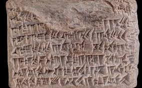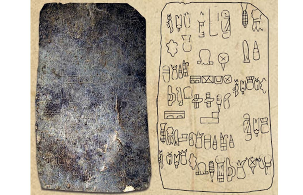
The Cascajal Block is one of the most controversial and exciting discoveries in Mesoamerican archaeology. Found in the late 1990s in a gravel pit in Veracruz, Mexico—the heartland of the Olmec civilization—it potentially pushes the dawn of writing in the Americas back to approximately 900 BCE.
If authentic, it suggests the Olmecs, often called the "Mother Culture" of Mesoamerica, were the first in the Western Hemisphere to develop a true system of writing, centuries before the Zapotecs or the Maya.
1. Discovery and Context
The block was discovered by road builders in the village of Cascajal. Because it wasn't found in a controlled stratigraphic excavation by archaeologists, its exact age has been a point of fierce debate.
Material: It is a tablet of serpentine, a greenish metamorphic rock highly prized by the Olmecs for its spiritual and aesthetic value.
Dating: Based on ceramic shards found in the same debris, researchers like Stephen Houston and Maria del Carmen Rodríguez Martínez dated the block to the San Lorenzo phase (c. 1200–900 BCE).
2. The Script: Decoding the Symbols
The block contains 62 symbols (glyphs), some of which repeat up to four times. Unlike later Mayan writing, which is usually arranged in vertical columns, the Cascajal Block appears to be read horizontally.
The Imagery: The glyphs are highly iconic. They include recognizable Olmec motifs:
Nature: Corn (maize), insects, and fish.
Objects: Throne-like chairs and what appear to be ritual tools.
The "Syntax": Because certain symbols repeat in specific patterns, linguists are confident this isn't just random art. It shows the hallmark of syntax—the arrangement of signs to create meaning, similar to a sentence.
3. Is It "True" Writing?
Archaeologists distinguish between iconography (pictures that represent things) and writing (symbols that represent language).
The Case for Writing: The sequences on the block are non-linear and seemingly follow grammatical rules. It doesn't look like a narrative scene (like a mural); it looks like a list or a ledger.
The "Isolate" Problem: The biggest challenge is that no other examples of this specific script have been found. True writing systems usually leave an evolutionary trail. Because the Cascajal script seems to have appeared and disappeared in a vacuum, some scholars remain skeptical.
4. The Controversy: Genuine or Fake?
The Cascajal Block has faced rigorous scrutiny. Critics point to several "red flags":
The "Horizontal" Problem: Almost every other known Mesoamerican script is written vertically.
The Surface: Some geologists noted that the weathering on the engraved lines looked remarkably crisp compared to the rest of the stone.
The Context: Because it wasn't found in situ (in its original place) by scientists, its "provenance" is considered weak by strict archaeological standards.
The Rebuttal: Proponents argue that the symbols are too perfectly aligned with known Olmec iconography from the San Lorenzo period to be a modern hoax. A forger would have had to be a master of Olmec art history to include the specific "maize" and "throne" symbols so accurately.
5. What Was Its Purpose?
Since we have no "Olmec Rosetta Stone," we can only guess based on the context of other Mesoamerican cultures.
Ritual Ledger: It could be a list of offerings or a calendar of religious festivals.
Erasability: Interestingly, the surface of the block is slightly concave. This suggests it may have been scraped and reused multiple times—a prehistoric "whiteboard" for a scribe.
6. The Olmec Legacy
Whether the Cascajal Block is the "First Script" or a unique ritual object, it reinforces the idea that the Olmecs were the intellectual architects of the Mesoamerican world, laying the groundwork for the complex calendars and writing systems of the Maya and Aztecs.
The Cascajal Block stands as a silent witness to a lost language. If we ever find a second block with similar symbols, it would officially rewrite the history of human literacy in the Western Hemisphere.
Since the Olmecs are famous for their "Colossal Heads" and massive stone altars, do you think they reserved writing for small, portable objects like this block for privacy, or were the large monuments originally covered in painted texts that have simply washed away over the millennia?