• MAIN PAGE
  • LATEST NEWS
    • Lost Cities
    • Archaeology's Greatest Finds
    • Underwater Discoveries
    • Greatest Inventions
    • Studies
    • Blog
  • PHILOSOPHY
  • HISTORY
  • RELIGIONS
    • Africa
    • Anatolia
    • Arabian Peninsula
    • Balkan Region
    • China - East Asia
    • Europe
    • Eurasian Steppe
    • Levant
    • Mesopotamia
    • Oceania - SE Asia
    • Pre-Columbian Civilizations of America
    • Iranian Plateau - Central Asia
    • Indus Valley - South Asia
    • Japan
    • The Archaeologist Editor Group
    • Scientific Studies
    • Aegean Prehistory
    • Historical Period
    • Byzantine Middle Ages
    • Predynastic Period
    • Dynastic Period
    • Greco-Roman Egypt
  • Rome
  • PALEONTOLOGY
  • About us
Menu

The Archaeologist

  • MAIN PAGE
  • LATEST NEWS
  • DISCOVERIES
    • Lost Cities
    • Archaeology's Greatest Finds
    • Underwater Discoveries
    • Greatest Inventions
    • Studies
    • Blog
  • PHILOSOPHY
  • HISTORY
  • RELIGIONS
  • World Civilizations
    • Africa
    • Anatolia
    • Arabian Peninsula
    • Balkan Region
    • China - East Asia
    • Europe
    • Eurasian Steppe
    • Levant
    • Mesopotamia
    • Oceania - SE Asia
    • Pre-Columbian Civilizations of America
    • Iranian Plateau - Central Asia
    • Indus Valley - South Asia
    • Japan
    • The Archaeologist Editor Group
    • Scientific Studies
  • GREECE
    • Aegean Prehistory
    • Historical Period
    • Byzantine Middle Ages
  • Egypt
    • Predynastic Period
    • Dynastic Period
    • Greco-Roman Egypt
  • Rome
  • PALEONTOLOGY
  • About us
No results found

The Hittite Empire: The Iron Age Superpower That Rivaled Egypt

May 11, 2026

The Hittite Empire: The Iron Age Superpower That Rivaled Egypt

For centuries, the Hittites were a "lost" civilization, known only through brief mentions in the Bible. However, archaeological excavations in the late 19th and early 20th centuries revealed a massive, sophisticated empire centered in the rugged highlands of modern-day Anatolia (Turkey). From their capital of Hattusa, the Hittites commanded a military and diplomatic machine that challenged the might of Pharaonic Egypt and the Middle Kingdom of Assyria.

1. Hattusa: The Mountain Fortress

The capital city, Hattusa, was a masterpiece of Bronze Age urban planning and defensive engineering. Built on a rocky outcrop, it was protected by massive double walls and innovative "postern" tunnels—secret underground passages that allowed soldiers to launch surprise counter-attacks during a siege.

  • The Lion Gate: One of the most iconic entrances to the city, guarded by two massive stone lions designed to magically protect the capital and project the "king’s ferocity."

  • The Great Temple: A sprawling complex dedicated to the Storm God Tarhunna and the Sun Goddess of Arinna. Unlike Egyptian temples, which were often hidden behind walls, Hittite temples featured large windows, reflecting a different approach to light and the divine.

  • The Royal Archives: Archaeologists discovered over 30,000 clay tablets written in cuneiform. These records revealed a highly organized state with laws, treaties, and even instructions for the "cleanliness of the royal kitchen."

2. The Chariot Revolution

The Hittites were the undisputed masters of chariot warfare. While other civilizations used chariots primarily as mobile archery platforms, the Hittites redesigned them for maximum impact.

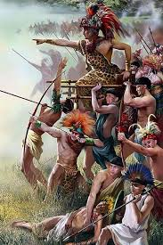
  • Three-Man Crews: Unlike the two-man Egyptian chariots, Hittite chariots carried three people: a driver, a shield-bearer, and a warrior armed with a long thrusting spear.

  • Centralized Axle: By moving the wheel axle to the middle of the chariot body (rather than the rear), they could support more weight, turning the chariot into a heavy "tank" capable of crashing directly into enemy infantry lines.

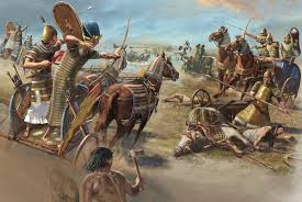
3. The Battle of Kadesh and the World’s First Peace Treaty

The rivalry between the Hittites and Egypt peaked in 1274 BCE at the Battle of Kadesh in modern-day Syria. It was the largest chariot battle ever fought, involving roughly 5,000 to 6,000 vehicles.

  • The Stalemate: Both King Muwatalli II and Pharaoh Ramesses II claimed victory, but the reality was a bloody draw.

  • The Eternal Treaty: Years later, in 1259 BCE, the two superpowers signed the Treaty of Kadesh. It is the oldest known written peace treaty in history. It established a "permanent" peace, a mutual defense pact against external threats, and even clauses for the extradition of political refugees. A clay copy of this treaty is currently on display at the United Nations Headquarters in New York.

4. The "Secret" of Iron

The Hittites are traditionally credited with ushering in the Iron Age. While they didn't mass-produce steel weapons in the modern sense, they were among the first to master the smelting of iron ore, which was abundant in the Anatolian mountains.

  • Prestige Metal: In the Late Bronze Age, iron was rarer and more valuable than gold. The Hittite kings used iron daggers as high-status gifts for other monarchs, signaling their technological edge.

  • Strategic Advantage: Their ability to work with iron, combined with their mastery of bronze, gave them a durable arsenal that lasted longer in the heat of sustained campaigns.

5. The Great Collapse

Around 1200 BCE, the Hittite Empire vanished almost overnight during the "Late Bronze Age Collapse."

  • Internal Strife: Evidence suggests the royal family was plagued by civil war and succession crises.

  • The Sea Peoples: Massive migrations and raids by the mysterious "Sea Peoples" disrupted trade routes and destroyed coastal cities.

  • Famine: Recent paleoclimate data (tree ring analysis) shows a severe, multi-year drought in Anatolia at the time of the collapse, likely causing the central government to fail as the food supply withered.

Roman Togas and Tunics: The Social Significance of Ancient Clothing

May 11, 2026

Roman Togas and Tunics: The Social Significance of Ancient Clothing

In ancient Rome, clothing was far more than a matter of fashion or comfort; it was a visual shorthand for a person’s rank, citizenship, and moral standing. To look at a Roman was to immediately understand their place in the complex social hierarchy.

1. The Tunic: The Universal Base Layer

The tunic (tunica) was the basic garment for all levels of society, from slaves to the Emperor. It was a simple, T-shaped garment made of two wool panels sewn together.

  • The Working Class: Laborers and slaves wore shorter tunics, often belted, to allow for freedom of movement. They were typically made of coarse, dark wool.

  • The Senatorial Stripes: High-ranking Romans wore tunics with vertical purple stripes called clavi.

    • Laticlavus: A broad purple stripe indicated a member of the Senatorial class.

    • Angusticlavus: Narrower stripes indicated the Equestrian (knightly) class.

2. The Toga: The Badge of Citizenship

The toga was the most iconic Roman garment, but it was strictly reserved for male Roman citizens. To wear one was a privilege; to be forbidden from wearing one was a sign of exile or loss of status.

  • Design and Difficulty: A toga was a massive semi-circular piece of fine wool, roughly 18 feet wide. It was not pinned or buttoned but meticulously draped over the body. It was heavy, hot, and required the wearer to keep their left arm partially tucked to hold the folds in place—a physical manifestation of the "dignity" expected of a citizen.

  • The Toga as a Political Tool:

    • Toga Virilis: A plain off-white wool toga worn by adult citizens.

    • Toga Praetexta: Featuring a purple border, worn by magistrates and young boys (to protect them with its "sacred" color).

    • Toga Candida: A toga rubbed with chalk to make it brilliantly white, worn by those running for office (hence the word "candidate").

    • Toga Pulla: A dark wool toga worn for mourning.

3. Women’s Attire: The Stola and Palla

Just as the toga signaled citizenship for men, clothing for Roman women signaled their marital status and modesty (pudicitia).

  • The Stola: The equivalent of the toga for respectable married women (matronae). It was a long, pleated dress worn over a tunic, often featuring shoulder straps (instita). It served as a visual "shield," marking the woman as off-limits to anyone but her husband.

  • The Palla: A rectangular shawl or wrap worn over the stola when outdoors. A modest woman would use the palla to veil her head in public.

4. The Color Purple: A Royal Monopoly

Color was perhaps the most expensive and regulated aspect of Roman dress.

  • Tyrian Purple: Extracted from thousands of tiny Murex sea snails, this dye was worth its weight in silver.

  • Sumptuary Laws: Over time, the state enacted laws to restrict the use of certain colors. Eventually, the Toga Picta—a solid purple toga embroidered with gold—was reserved exclusively for victorious generals during a Triumph and, later, only for the Emperor.

The Grotte Chauvet: Exploring the Oldest Known Figurative Cave Paintings

May 11, 2026

The Grotte Chauvet: Exploring the Oldest Known Figurative Cave Paintings

Discovered in 1994 by a team of three speleologists led by Jean-Marie Chauvet, the Chauvet-Pont-d'Arc Cave in southern France is one of the most significant archaeological sites in human history. Its discovery pushed back the timeline of advanced human artistic expression by thousands of years, revealing that our ancestors were master artists as early as the Upper Paleolithic.

1. A Time Capsule in Limestone

The cave was sealed by a rockfall approximately 21,000 years ago, creating a pristine "time capsule" that preserved not only the paintings but also the footprints of children and animals, and even the remains of cave bears.

  • Dating the Art: Using radiocarbon dating, scientists determined the cave was occupied during two distinct periods: the Aurignacian (c. 37,000 to 33,500 years ago) and the Gravettian (c. 31,000 to 28,000 years ago).

  • The "Lascaux" Comparison: Before Chauvet, the famous Lascaux Cave (c. 17,000 years old) was considered the peak of prehistoric art. Chauvet proved that humans were creating equally sophisticated art nearly 20,000 years earlier.

2. The Masterpieces of the Deep

The artwork in Chauvet is remarkably different from other Paleolithic caves in terms of both technique and subject matter.

  • The Bestiary of Predators: While most cave art focuses on hunted animals like deer or bison, Chauvet features a high percentage of dangerous predators: lions, panthers, bears, and hyenas.

  • The Panel of Lions: This massive mural depicts a pride of lions in a hunting stance. The artists used sophisticated shading and overlapping techniques to create a sense of depth and movement.

  • The Panel of Horses: This panel showcases a remarkable use of charcoal to create anatomical detail and "stumping" (smudging) to provide three-dimensional volume to the horses' heads.

3. Advanced Techniques and "Pre-Cinema"

The Chauvet artists utilized the natural contours of the cave walls to give their paintings life.

  • The Illusion of Movement: By painting an animal with multiple sets of legs or heads in slightly different positions, the artists created a "strobe-light" effect. When viewed by the flickering light of a torch, these animals would appear to run or shake their heads.

  • Preparation of the "Canvas": Unlike later caves where artists painted directly onto the stone, the Chauvet artists often scraped the walls clean of debris and film before painting, creating a bright, smooth surface that enhanced the vibrancy of the pigments.

4. Human Presence and Ritual

The cave was not a dwelling; it was likely a sacred or ritualistic space.

  • Hand Stencils: One of the most haunting features is a series of "positive" and "negative" handprints. One specific individual, identifiable by a slightly crooked pinky finger, left prints throughout the cave, allowing us to follow a single human's journey through the darkness 30,000 years ago.

  • The Venus and the Sorcerer: In the deepest part of the cave, painted on a hanging limestone pendant, is a depiction of a female lower body (the "Venus") intertwined with a bison-headed figure (the "Sorcerer"). This suggests a complex mythological or shamanic belief system.To protect the fragile environment and prevent the growth of mold (which damaged Lascaux), the original cave is closed to the public. However, a stunning, full-scale replica called Chauvet 2 was opened nearby, allowing visitors to experience the awe of the "First Artists."

Ancient Greek Architecture: The Optical Illusions of the Parthenon

May 11, 2026

Ancient Greek Architecture: The Optical Illusions of the Parthenon

The Parthenon, standing atop the Athenian Acropolis, is often cited as the pinnacle of Doric architecture. However, its reputation for perfection is a bit of a trick. Built between 447 and 432 BCE by the architects Iktinos and Kallikrates, the temple contains almost no straight lines. The Greeks understood that a perfectly "true" geometric building would appear sagging, distorted, or fragile to the human eye. To correct this, they employed a series of sophisticated "optical refinements"

1. Entasis: The Swelling of the Columns

If a column were a perfect cylinder, the human eye would perceive it as being slightly concave—as if it were "pinched" in the middle and under too much weight.

  • The Solution: The architects gave the columns a subtle outward curve, or "swelling," known as entasis.

  • The Effect: This slight bulge makes the columns appear straight and strong, as if they are actively "muscling" up to support the massive weight of the roof.

  • mikroman6

2. Curvature of the Horizontal Lines

On a building as large as the Parthenon, a perfectly flat base (the stylobate) would appear to sag in the middle when viewed from a distance.

  • The Solution: The entire floor of the Parthenon is actually a shallow dome. The center of the long sides is about 11 centimeters (4.3 inches) higher than the corners, and the short sides rise by about 6 centimeters.

  • The Result: To someone standing at a distance, the foundation looks perfectly level. If it were actually flat, it would look like it was bowing downward toward the earth.

3. The Lean: Vertical Inclination

To the human eye, tall vertical parallel lines often appear to "fan out" at the top, making the building look like it is about to burst outward.

  • The Solution: Every column in the Parthenon leans slightly inward. If you were to extend the lines of the columns upward, they would all meet at a single point approximately 2.4 kilometers (1.5 miles) in the air.

  • Corner Reinforcement: The corner columns are actually about 2.5% thicker than the others. Because they are seen against the bright sky rather than the dark interior of the temple, "irradiation" would make them look thinner if they were the same size as the rest.

4. The Triglyphs and the Corner Problem

In the Doric order, the frieze consists of alternating triglyphs (three-grooved panels) and metopes (sculpted panels). Standard rules dictated that a triglyph should sit centered over every column.

  • The Problem: At the corners, this rule would leave a "dangling" half-metope, which looked architecturally weak.

  • The Adjustment: The architects slightly moved the corner triglyphs toward the ends and "contracted" the space between the last two columns. This subtle shift in spacing (intercolumniation) is almost invisible to the casual observer but creates a sense of solid, closed boundaries for the structure.

The Roman Calendar: From the Founding of Rome to the Julian Reform

May 11, 2026

The Roman Calendar: From the Founding of Rome to the Julian Reform

The Roman calendar was not a static system; it was a living, breathing, and often chaotic tool of both timekeeping and political control. It evolved from a primitive lunar cycle into a sophisticated solar-based system that still forms the backbone of the Gregorian calendar we use today.

1. The Calendar of Romulus (c. 753 BCE)

According to legend, Rome’s first king, Romulus, established a 10-month calendar. This system reflected the priorities of an early agricultural and military society.

  • The Missing Winter: The calendar only covered 304 days. It began in March (Martius, named for the god of war and the start of the campaign season) and ended in December.

  • A "Gap" in Time: The remaining ~61 days of winter were simply not counted or named. It was a "dead time" where no agricultural or military activities took place, and the Romans essentially waited for the spring equinox to reset the year.

  • The Months: Many of the names survive today: Martius, Aprilis, Maius, Iunius, followed by numerical names: Quintilis (5th), Sextilis (6th), September (7th), and so on.

2. The Reform of Numa Pompilius (c. 713 BCE)

The second king of Rome, Numa Pompilius, attempted to align the calendar more closely with the lunar year by adding two new months to the end of the winter gap.

  • January and February: Ianuarius (named for Janus, god of beginnings) and Februarius (named for februa, the ritual of purification) were added.

  • Superstition and Odd Numbers: Romans believed even numbers were unlucky. Numa changed the month lengths so they were mostly 29 or 31 days. To reach a total of 355 days (a lunar year), one month (Februarius) had to remain even-numbered at 28 days, but it was considered acceptable because it was a month of purification and the dead.

3. The Chaos of Intercalation

Because a 355-day lunar year eventually drifts away from the 365.25-day solar seasons, the Romans had to "intercalate" (insert) an extra month.

  • Mercedonius: Every two years, a 27-day month called Mercedonius was inserted after February 23rd or 24th.

  • Political Weaponization: The power to decide when to add this month rested with the Pontifex Maximus (the high priest). By the late Republic, priests began abusing this power—shortening the year when their political enemies were in office or lengthening it when their allies held power.

  • The "Year of Confusion": By the time of Julius Caesar, the calendar was so misaligned that the harvest festivals were occurring in the wrong seasons.

4. The Julian Reform (46 BCE)

As Pontifex Maximus, Julius Caesar sought a permanent solution. Working with the Alexandrian astronomer Sosigenes, he abandoned the lunar model for a solar one.

  • Resetting the Clock: To fix the drift, Caesar made the year 46 BCE last 445 days. It was known as the annus confusionis (year of confusion).

  • 365.25 Days: The new calendar set the year at 365 days, with an extra "leap day" added every four years in February.

  • Month Re-alignment: Caesar distributed the extra ten days among the existing months to reach the totals we recognize today (30, 31, and 28/29 days).

  • Legacy Names: Following his assassination, Quintilis was renamed July (Iulius) in his honor. Later, Sextilis was renamed August (Augustus) for his successor.

Ancient Mayan Warfare: Was the "Peaceful Maya" Theory a Myth?

May 10, 2026

Ancient Mayan Warfare: Was the "Peaceful Maya" Theory a Myth?

For much of the early 20th century, archaeologists viewed the Classic Maya (c. 250–900 CE) as a peaceful, utopian society of priest-astronomers who lived in quiet contemplation of the stars. This "Peaceful Maya" theory, championed by scholars like J. Eric S. Thompson, has been thoroughly dismantled over the last few decades by new breakthroughs in epigraphy (the study of inscriptions) and advanced archaeological technology.

The reality was far more complex: the Maya were a sophisticated but highly competitive civilization engaged in centuries of strategic, ritualized, and occasionally total warfare.

1. The Decipherment of the Glyphs

The primary catalyst for the shift in perspective was the deciphering of Mayan hieroglyphs. As scholars began to read the inscriptions on stelae (stone monuments) and temple walls, the "priests" were revealed to be "warrior-kings."

  • Verbs of Conquest: Inscriptions are filled with specific terms for conflict: chuhaj (to be burned), puluy (to be torched), and the ominous star-war glyph—a celestial alignment (usually involving Venus) that signaled a total, high-stakes military campaign against a rival city.

  • The Captive Narrative: Maya art is obsessed with the humiliation of enemies. Dozens of stone carvings depict defeated lords being stripped of their finery, bound with rope, and trampled under the feet of the victor.

2. LiDAR and the "Fortress" Landscape

The most recent nail in the coffin of the "Peaceful Maya" myth has been LiDAR (Light Detection and Ranging). By stripping away the dense jungle canopy with lasers, archaeologists discovered that Maya cities were far more fortified than previously thought.

  • Defensive Infrastructure: LiDAR has revealed miles of defensive walls, ditches, and ramparts around cities like Tikal and Aguateca. These were not ceremonial boundaries; they were functional military fortifications designed to withstand prolonged sieges.

  • High-Ground Settlements: In many regions, the Maya moved their entire populations to hilltop fortresses during times of intense conflict, creating "shatter zones" between warring superpowers.

3. The Nature of the Conflict

Maya warfare evolved significantly over the centuries, moving from ritualized capture to widespread destruction.

  • Elite Capture: In the Early Classic period, warfare often focused on the capture of high-ranking individuals. Taking a rival king alive provided immense political and religious prestige, as the captive would eventually be sacrificed to nourish the gods.

  • The "Star Wars": Certain military campaigns were timed to astronomical events. The most famous was the war between Tikal and Calakmul, two "superpower" city-states that engaged in a centuries-long proxy war that reshaped the entire Maya world.

  • Total War and Environmental Collapse: Toward the end of the Classic period (9th century), warfare became more desperate and destructive. The scorched-earth tactics of this era—burning crops and destroying irrigation systems—likely contributed to the agricultural failures and the eventual "collapse" of the great southern lowland cities.

4. Weapons and the Warrior Class

The Maya did not have metal weapons, but they were masters of lithic (stone) technology.

  • Obsidian and Chert: The primary weapons were spears and clubs edged with razor-sharp obsidian or chert. The atlatl (spear-thrower) allowed warriors to launch projectiles with enough force to penetrate leather armor.

  • Cotton Armor: Elite warriors wore thick, quilted cotton tunics soaked in brine to harden them. This was surprisingly effective against stone-tipped arrows and spears.

  • The Maya were not uniquely violent compared to other ancient civilizations, but they were certainly not pacifists. Their history was a delicate balance between high artistic achievement and the harsh realities of geopolitical competition.

The Temple of Solomon: Searching for Physical Evidence in Jerusalem

May 10, 2026

The Temple of Solomon: Searching for Physical Evidence in Jerusalem

The Temple of Solomon, also known as the First Temple, is described in the Hebrew Bible as a magnificent structure built by King Solomon in the 10th century BCE on Mount Moriah. It served as the spiritual and political center of ancient Israel until its destruction by the Babylonians in 586 BCE. Despite its historical and religious significance, finding direct physical evidence of the structure remains one of the most complex challenges in biblical archaeology.

1. The Archaeological Barrier: The Temple Mount

The primary reason for the lack of direct evidence is the site itself. The First Temple is believed to have stood on the Temple Mount (Har HaBayit) in the Old City of Jerusalem.

  • Continuous Use: The site has been built over repeatedly. King Herod the Great radically transformed the topography in the 1st century BCE to build the Second Temple, and today, the site is home to the Dome of the Rock and the Al-Aqsa Mosque.

  • Political and Religious Sensitivity: Because the Temple Mount is a holy site for Jews, Christians, and Muslims, large-scale archaeological excavations on the platform itself are strictly prohibited.

  • The Second Temple Overhang: Herod’s massive retaining walls (including the Western Wall) likely encased or destroyed any remaining surface-level foundations of Solomon’s earlier structure.

2. Indirect Evidence: "Proxies" of the First Temple

Since archaeologists cannot dig under the Temple Mount, they look for "proxies"—contemporary structures or artifacts that reflect the architectural and cultural world of 10th-century Jerusalem.

  • The "Ain Dara" Temple: In northern Syria, archaeologists discovered a temple at Ain Dara that dates to the same period. It shares a striking "tripartite" layout with the biblical description of Solomon’s Temple: a porch (ulam), a main hall (heikhal), and a "Holy of Holies" (debir).

  • Proto-Aeolic Capitals: Distinctive stone capitals (the tops of columns) featuring stylized palm fronds have been found in the City of David and at other royal sites like Hazor and Megiddo. These represent the "Solomonic" architectural style mentioned in the Bible.

  • The Ophel Excavations: Just south of the Temple Mount, archaeologists like Eilat Mazar have uncovered massive 10th-century BCE walls and a gatehouse. Some argue these are part of the royal fortifications built by Solomon to connect his palace to the Temple.

3. The Temple Mount Sifting Project

In 1999, unauthorized construction on the Temple Mount resulted in thousands of tons of ancient soil being dumped in the Kidron Valley. Since 2004, the Temple Mount Sifting Project has been systematically washing this "debris" to recover artifacts.

  • First Temple Period Finds: While no "building blocks" of the temple were found, the project has recovered:

    • Seal Impressions (Bullae): Clay seals belonging to high-ranking officials mentioned in the Bible.

    • Weights: Stone scales used for trade, indicating a sophisticated central administration.

    • Pottery: Shards dating back to the Iron Age II (10th–6th centuries BCE), proving human activity on the Mount during the First Temple era.

4. Technical Challenges and the "Minimalist" Debate

The search for Solomon’s Temple is at the center of a major debate in archaeology between "Maximalists" (who believe the biblical account is largely historical) and "Minimalists" (who believe the United Monarchy was a much smaller, less grand entity).

  • The Radiocarbon Problem: Determining the exact date of 10th-century structures is difficult because of a "plateau" in the radiocarbon calibration curve, leading to a margin of error that covers several decades.

  • Absence of Evidence vs. Evidence of Absence: Archaeologists caution that the lack of a "foundation stone" with Solomon’s name on it does not mean the building didn't exist; rather, it reflects the total destruction of the site and the limitations of modern access.

Roman Aqueducts: The Precision Surveying Behind the Pont du Gard

May 10, 2026

Roman Aqueducts: The Precision Surveying Behind the Pont du Gard

The Pont du Gard in southern France is more than just a picturesque bridge; it is a masterpiece of hydraulic engineering. Part of a 50-kilometer (31-mile) aqueduct system that supplied the city of Nemausus (Nîmes), it stands as a testament to the incredible precision of Roman surveying. To keep the water flowing by gravity alone, Roman engineers had to maintain a incredibly shallow gradient over rugged terrain.

1. The Challenge: A Gradient of Inches

The source of the water was the Fontaine d'Eure at Uzès, which sat only 12 meters higher than the delivery point in Nîmes.

  • The Math: Over the 50 km length of the aqueduct, this averages out to a gradient of only 24 centimeters per kilometer (about 1 inch every 400 feet).

  • The Pont du Gard Section: At the bridge itself, the precision is even more staggering. The water channel (specus) across the top of the bridge drops only 2.5 centimeters over its 275-meter length—a gradient of nearly 1 in 10,000.

2. The Surveyor’s Toolkit: Groma, Chorobates, and Dioptra

How did the Romans achieve such precision without modern lasers or GPS? They used three primary instruments to measure horizontal lines and vertical angles.

The Chorobates (The Level)

This was the most critical tool for aqueducts. It was a 20-foot-long wooden bench with a groove on top filled with water to act as a level. Plumb lines on the sides ensured the bench itself was perfectly horizontal.

  • Use: It allowed engineers to sight a perfectly level line across long distances, from which they could calculate the necessary "drop" for the next section.

The Groma (The Square)

The groma consisted of a vertical staff with a horizontal cross on top, from which four plumb lines hung.

  • Use: It was used to survey straight lines and right angles, ensuring the aqueduct followed a predictable path through the landscape.

The Dioptra (The Angle Finder)

A more advanced Greek-inspired tool, the dioptra used a sighting tube and cogwheels to measure both horizontal and vertical angles. It was particularly useful for tunneling through hills.

3. Structural Brilliance: The Three Tiers

The Pont du Gard had to cross the Gardon River valley. To maintain the gradient, the water had to stay at a height of 48 meters (160 feet) above the river.

  • Independent Arches: The bridge was built without mortar. The massive stones, some weighing up to six tonnes, were cut so precisely they stayed in place by gravity alone.

  • Maintenance Features: Protruding stones on the facade were left in place to support the scaffolding for future repairs, showing that the Romans designed for longevity and ease of maintenance.

  • The Specus (Water Channel): The interior of the channel was lined with opus signinum (a waterproof lime mortar mixed with crushed brick) and smoothed to minimize friction, ensuring the slow-moving water didn't stagnate or overflow.

4. The Castellum Divisorium: Urban Distribution

Once the water survived the journey over the Pont du Gard and reached Nîmes, it entered a circular distribution basin called a Castellum Divisorium.

  • Priority System: The basin featured lead pipes at different heights. The lowest pipes supplied the public fountains (the highest priority), while higher pipes supplied the public baths and eventually private villas.

  • The Siphon: In areas where the terrain was too deep for a bridge, the Romans used "inverted siphons"—lead pipes that used the pressure of the falling water to push it back up the opposite hill.

The Viking Siege of Paris: Archaeology of the 9th Century Conflict

May 10, 2026

The Viking Siege of Paris: Archaeology of the 9th Century Conflict

The Siege of Paris in 885–886 CE remains one of the most dramatic confrontations of the Viking Age. A massive fleet of hundreds of Viking ships, carrying an estimated 30,000 warriors, sailed up the Seine to challenge the Frankish Empire. Unlike the quick "hit-and-run" raids of previous decades, this was a prolonged, tactical siege that tested the limits of early medieval urban defense.

1. The Fortifications: The Île de la Cité

In the 9th century, Paris was largely confined to the Île de la Cité, an island in the middle of the Seine. Following earlier Viking raids, the Frankish king Charles the Bald had ordered the city’s Roman walls to be reinforced and new defenses to be built.

  • The Low Bridges: The most critical defense consisted of two bridges—the Grand Pont (North) and the Petit Pont (South)—that blocked the river. These bridges were fortified with wooden towers (châtelets) that prevented the Viking longships from sailing further inland.

  • Archaeological Traces: Excavations on the Île de la Cité have revealed traces of these late Carolingian reinforcements. Archaeologists have found evidence of deep pits and post-holes intended for massive defensive timbers, as well as the remains of the Roman stone walls that were frantically patched with rubble during the 9th-century incursions.

2. Viking Siege Technology and Tactics

The 885 siege marked a shift in Viking warfare from raiding to sophisticated siegecraft. According to the monk Abbo Cernuus, an eyewitness, the Vikings employed weapons typically associated with Roman or Byzantine warfare.

  • Battering Rams and Catapults: The Vikings constructed protective sheds (vineae) to move battering rams toward the city towers. They also used mangonels (catapults) to hurl stones into the city.

  • Fire Ships: In a desperate attempt to destroy the wooden Grand Pont, the Vikings filled three of their ships with dry wood and lit them aflame, drifting them toward the bridge. However, the ships ran aground before hitting their target—a moment captured in historical chronicles and supported by riverbed silt analysis showing 9th-century charcoal deposits.

3. The Archaeological Evidence of Conflict

While the wooden structures of 9th-century Paris have mostly rotted away, the "invisible" evidence of the siege remains in the soil.

  • Weaponry Finds: Dredging operations in the Seine have recovered numerous Viking-style swords, spearheads, and battleaxes dating to the mid-to-late 9th century. Many of these items show signs of battle damage, such as notched blades or bent tips.

  • Arrowheads: Archaeologists have uncovered a high concentration of Carolingian and Scandinavian arrowheads near the site of the former bridges. The variation in tip design—some broad for tearing flesh, others narrow and "bodkin" shaped for piercing mail—highlights the intensity of the exchange.

  • The "Viking" Camp: While the primary Viking camp at Saint-Germain-des-Prés has been largely built over, small finds of Scandinavian-style jewelry and coins in the surrounding areas suggest the presence of a semi-permanent settlement during the eleven-month siege.

4. The Outcome: A Ransom of Gold

The siege ended not with a military breakthrough, but with a controversial political deal. Charles the Fat, the Frankish Emperor, arrived with a relief army but chose to negotiate rather than fight.

  • The Danegeld: Charles promised the Vikings 700 pounds of silver to leave Paris and allowed them to continue up the Seine to raid Burgundy, which was then in revolt.

  • Political Shift: This "cowardly" deal led to the eventual deposition of Charles the Fat and the rise of Odo, Count of Paris, whose heroic defense of the city laid the foundations for the future Capetian dynasty and the modern French state.

Ancient Metallurgy in the Andes: The Moche Goldsmiths of Sipan

May 10, 2026

Ancient Metallurgy in the Andes: The Moche Goldsmiths of Sipan

The Moche civilization, which flourished on the northern coast of Peru between 100 and 700 CE, was home to the most skilled goldsmiths of the ancient Americas. Long before the Inca Empire, the Moche mastered complex chemical and mechanical processes that allowed them to transform raw ores into intricate regalia. The 1987 discovery of the Royal Tombs of Sipán provided a spectacular look at this artistry, revealing treasures that had remained untouched for over 1,500 years.

1. The Lord of Sipán: A Discovery of Riches

Until the late 20th century, much of what we knew about Moche metallurgy came from looted artifacts. The excavation at Sipán, led by archaeologist Walter Alva, changed everything by uncovering the intact burial of a high-ranking priest-king.

  • The Sarcophagus: The "Lord of Sipán" was buried with an overwhelming amount of metalwork, including a gold face mask, massive pectorals (chest plates), and necklaces.

  • The Peanut Necklace: One of the most famous items is a necklace made of 20 oversized peanut beads—10 crafted in gold and 10 in silver. This symbolized the Andean concept of duality: the sun and the moon, day and night, and the balance of opposing forces.

2. Advanced Metallurgical Techniques

The Moche were not just artists; they were sophisticated chemists. They worked with gold, silver, copper, and various alloys, most notably tumbaga (a mix of gold and copper).

  • Depletion Gilding: The Moche developed a process to make copper objects look like solid gold. They would create an alloy of copper and a small amount of gold, then use acidic plant juices to dissolve the copper from the surface, leaving a thin, brilliant layer of pure gold.

  • Soldering and Welding: They were masters of "hard soldering," using alloys with lower melting points to join complex pieces together without melting the main structure.

  • Electro-Chemical Plating: Remarkably, the Moche used a form of "wet" gilding. By dissolving gold or silver in a solution of corrosive minerals (like salt and alum), they could chemically deposit a microscopic layer of precious metal onto copper—a precursor to modern electroplating.

3. Symbolism and Status

In Moche society, metal was not a form of currency, but a medium for religious expression and social hierarchy.

  • Solar and Lunar Power: Gold was associated with the sun and the male creative force, while silver was linked to the moon and the female. Wearing both simultaneously signified the wearer’s role as a mediator between the earthly and divine realms.

  • Shamanic Transformation: Many pieces of jewelry, such as earspools and nose ornaments, depicted humans transforming into jaguars, owls, or decapitator gods, reflecting the shamanic rituals performed by the elite.

4. The Moche Workshop

Excavations of Moche workshops show that metallurgy was a highly organized state activity.

  • Smelting: They used ceramic blowpipes to increase the temperature of charcoal fires to over 1,000°C, enough to melt copper.

  • Mass Production: While each royal piece was unique, the Moche used stone molds to mass-produce standardized elements, such as small beads or bells, which were then individually finished by master craftsmen.

The Caral-Supe Civilization: The Oldest Urban Center in the Americas

May 10, 2026

The Caral-Supe Civilization: The Oldest Urban Center in the Americas

While the great civilizations of the Maya, Aztecs, and Incas are household names, the foundations of complex society in the Americas were laid thousands of years earlier in the arid Norte Chico region of north-central Peru. The Caral-Supe civilization, which flourished between 3000 and 1800 BCE, represents the oldest known urban center in the Americas—thriving at the same time the Great Pyramids were being built in Egypt.

1. The Sacred City of Caral

Located in the Supe Valley, about 120 miles north of Lima, Caral is the most impressive of the approximately 30 major centers found in the region.

  • Monumental Architecture: The city spans over 150 acres and is dominated by six massive earth-and-stone platform mounds, known as pyramids. The largest, the Pirámide Mayor, stands nearly 60 feet tall and is as long as four football fields.

  • Circular Plazas: A signature feature of Caral-Supe architecture is the sunken circular plaza. These served as ceremonial and social hubs, likely used for religious rituals that unified the growing urban population.

  • A City Without Walls: Notably, Caral lacks defensive walls, battlements, or evidence of warfare. This suggests a civilization built on trade and religion rather than military conquest.

2. The Maritime-Foundations Theory

For decades, archaeologists believed that all great civilizations began with the surplus of a cereal grain (like wheat in Mesopotamia or maize in Mexico). Caral challenged this "breadbasket" model.

  • Cotton and Fish: The inhabitants of Caral did not rely on grain. Instead, they grew massive amounts of cotton, which they used to make sophisticated fishing nets.

  • Symbiotic Trade: They traded their cotton nets to coastal fishing villages in exchange for protein-rich seafood, such as anchovies and sardines. This "Maritime Foundation of Andean Civilization" allowed for a massive population explosion without traditional agriculture.

3. Scientific and Musical Achievement

The people of Caral were not just builders; they were sophisticated engineers and artists.

  • Quipu (The String Records): Archaeologists discovered a quipu (a series of knotted strings) at the site. This suggests that the complex record-keeping system famously used by the Incas 4,000 years later actually had its origins in Caral.

  • Musical Hoards: One of the most stunning finds was a hoard of 32 flutes made of condor and pelican bones, and 38 cornets made of deer and llama bones. This indicates that music played a central role in their religious and social ceremonies.

  • Earthquake Engineering: To protect their massive pyramids, the builders used "shicras"—woven reed bags filled with stones. These functioned as a rudimentary seismic mitigation system, allowing the structures to shift slightly during tremors without collapsing.

4. The Enigma of the Decline

Around 1800 BCE, the Caral-Supe civilization began to decline. The cities were abandoned, and the population moved further north and into the highlands.

  • Climate Change: Many researchers believe a series of prolonged droughts, combined with El Niño-driven flooding and sandstorms, choked the irrigation canals and made the Supe Valley uninhabitable.

  • Tectonic Shifts: Evidence suggests that massive earthquakes may have destabilized the landscape, causing mountain landslides that buried fertile coastal lands.

Roman Law and Order: The Twelve Tables and Archaeological Evidence of Justice

May 10, 2026

Roman Law and Order: The Twelve Tables and Archaeological Evidence of Justice

The Roman legal system is arguably Rome's most enduring legacy, forming the basis for civil law in much of the modern world. It evolved from a collection of unwritten sacred customs into a highly structured, transparent system of codified statutes. This transition began with a moment of social crisis and resulted in the creation of the Twelve Tables.

1. The Birth of the Twelve Tables (451–450 BCE)

Early in the Roman Republic, law was the exclusive domain of the Patricians (the aristocratic class), who interpreted unwritten customs to their own advantage. The Plebeians (the common citizens) demanded that the laws be written down so that all might know their rights and duties.

  • The Decemviri: A special commission of ten men was appointed to draft the code. According to tradition, they were sent to Greece to study the laws of Solon before carving the Roman statutes onto bronze tablets.

  • Public Display: The tables were set up in the Forum Romanum, the heart of the city's political life. This was a revolutionary act: it moved law from the "secret" knowledge of priests and elites into the public square.

  • Content: The tables covered everything from trial procedures and debt to "paternal power" (patria potestas) and funeral rites. While many of the laws were harsh (e.g., a debtor could be cut into pieces by his creditors), they established the principle that the law applies to everyone.

2. Archaeological Evidence of the Roman Forum

While the original bronze tablets of the Twelve Tables were likely destroyed during the Gallic Sack of Rome in 390 BCE, the physical space where justice was administered remains.

  • The Rostra: This was the speaker's platform in the Forum. It was here that laws were proposed and where the heads of "enemies of the state" were sometimes displayed as a grim warning of the consequences of breaking Roman law.

  • The Basilica: These large, roofed halls (such as the Basilica Julia) were the primary sites for civil courts. Archaeologists have found "gaming boards" scratched into the steps of these buildings, likely made by bored spectators or litigants waiting for their cases to be heard.

  • The Mamertine Prison (Carcer): Located near the Forum, this was a small, subterranean dungeon used for high-profile prisoners. It wasn't a place for long-term "sentences" but rather a holding cell for those awaiting execution or being displayed in a Triumphal parade.

3. Symbols and Tools of Justice

Roman justice was highly visual, designed to project authority (auctoritas) and fear.

  • The Fasces: This was a bundle of wooden rods tied together with an axe. Carried by Lictors (bodyguards for magistrates), it symbolized the state’s power to punish: the rods for scourging (beating) and the axe for execution.

  • Stelae and Inscriptions: Across the empire, archaeologists have found stone inscriptions of imperial edicts. These "law stones" ensured that even in remote provinces like Britain or Syria, the local population knew the boundaries of Roman order.

4. The Evolution of Punishment

Archaeological finds in Roman provinces reveal how justice was applied "on the ground."

  • Curse Tablets (Defixiones): When the formal legal system failed, Romans turned to the supernatural. Hundreds of lead tablets have been found in springs (like those at Bath, England) where victims of theft "sued" the criminal in the court of the gods, asking a deity to torment the thief until the stolen goods were returned.

  • Execution Sites: Archaeological excavations near city walls have uncovered mass graves and evidence of crucifixions—a punishment reserved for slaves, rebels, and the lowest classes, designed to be as public and agonizing as possible.

Summary of the Roman Legal Framework

ConceptDefinitionSignificanceLexWritten LawStatutes passed by assemblies, like the Twelve Tables.IusThe Body of LawThe overall concept of "Right" or justice.PraetorThe MagistrateThe official responsible for overseeing the courts and "editing" the law each year.ProvocatioRight of AppealThe right of a citizen to appeal a death sentence to the people.

The transition from the harsh Twelve Tables to the sophisticated Justinian Code nearly a thousand years later represents the peak of ancient legal thought.

The Mystery of the Easter Island Statues: Red Pukao and Birdman Rituals

May 10, 2026

The Mystery of the Easter Island Statues: Red Pukao and Birdman Rituals

Easter Island, or Rapa Nui, is home to one of the most recognizable archaeological wonders in the world: the Moai. While the massive stone heads and torsos are famous, the island’s history involves complex layers of engineering and social evolution, specifically regarding the "hats" found on certain statues and the later transition to a radical new religious system.

1. The Red Pukao: The "Hats" of the Moai

Many of the Moai were originally crowned with massive, cylindrical stones made of red scoria (a light volcanic rock) known as Pukao.

  • The Symbolic Meaning: Scholars believe Pukao represented the hair or topknots of the ancestors the Moai depicted. In Rapa Nui culture, the head was considered the seat of mana (supernatural power), and long hair was a sign of status and strength.

  • Engineering Feat: These red cylinders can weigh up to 13 tons. Because the red scoria was quarried from a different location (Puna Pau) than the Moai themselves, they had to be transported and hoisted onto the heads of statues that were already standing up to 33 feet tall.

  • The "Parbuckling" Theory: Recent research suggests the Pukao were not lifted vertically but rolled up massive ramps using a technique called parbuckling—wrapping a rope around the cylinder and pulling from the top of the ramp to minimize the force needed.

2. The Collapse and the "Huri Moai"

By the 18th century, the era of Moai construction came to a violent end. This period, known as Huri Moai (the "overturning of the statues"), saw the islanders topple the monuments that their ancestors had spent centuries carving.

  • Environmental Strain: Traditional theories suggest that deforestation and overpopulation led to resource scarcity and tribal warfare.

  • Spiritual Disillusionment: As the statues failed to protect the islanders from ecological decline, rival clans began toppled each other's Moai to "break" the mana of their enemies. Most statues were found face-down, often with their necks broken by the fall.

3. The Birdman Cult (Tangata Manu)

As the ancestor worship associated with the Moai faded, a new, more competitive social order emerged: the Birdman Cult. Based in the stone village of Orongo, perched on the rim of the Rano Kau volcano, this ritual determined which clan would rule the island for the coming year.

  • The Competition: Every spring, the most athletic men (representing their chiefs) would climb down the 1,000-foot sea cliffs of Orongo and swim through shark-infested waters to the tiny islet of Moto Nui.

  • The Goal: The contestants had to find the first egg of the Sooty Tern (a migratory bird), swim back, and climb the cliffs without breaking the egg.

  • The Victor: The man who presented the intact egg to his chief was named the Tangata Manu (Birdman). For the next year, his clan gained exclusive rights to the island's limited resources.

4. Petroglyphs and Iconography

The shift from the Moai to the Birdman Cult is recorded in the island's rich rock art. At Orongo, hundreds of petroglyphs depict figures with human bodies and bird heads, often clutching eggs.

  • Makemake: This new religion centered on the creator god, Makemake, who was believed to have brought the birds to the island.

  • Transition of Power: The Birdman rituals replaced a system of inherited power with one based on physical prowess and divine favor, a necessary adaptation for a society struggling to survive on a depleted landscape.

Ancient Greek Wine: The Additives and Aging Processes of the Symposium

May 10, 2026

Ancient Greek Wine: The Additives and Aging Processes of the Symposium

In ancient Greece, wine was not just a beverage; it was a medium for social cohesion, philosophical debate, and religious ritual. However, the wine consumed at a Symposium (a formal drinking party) would be unrecognizable to most modern palates. Because ancient Greek wines were often high in alcohol and prone to oxidation, they were rarely consumed "neat" and were frequently altered with various additives to improve flavor and shelf life.

1. The Cultivation and Harvest

The Greeks took viticulture seriously, often planting vines in volcanic soil or near the sea to imbue the grapes with specific mineral qualities.

  • Sun-Drying: To increase sugar content and create a more potent, syrupy wine, Greeks often practiced "passito"—leaving the grapes to dry in the sun after picking. This resulted in wines with high residual sugar and alcohol levels.

  • The Press: After treading the grapes by foot, the juice was fermented in large terracotta jars called pithoi, which were often buried in the ground to maintain a cool, stable temperature.

2. Additives: Enhancing Flavor and Stability

Ancient Greek wine was frequently thick, pungent, and sometimes harsh. Additives served two purposes: masking spoilage and creating complex flavor profiles.

  • Seawater: A famous practice, particularly on the island of Chios, involved adding seawater to the must. This was believed to smooth out the wine, act as a preservative, and improve the "nose."

  • Resin and Pitch: To seal the porous terracotta jars and prevent oxygen from turning the wine into vinegar, the Greeks coated the insides with pine resin. This gave birth to Retsina, a style of wine still produced in Greece today.

  • Spices and Aromatics: For special occasions, wine was infused with honey, herbs (like thyme or mint), cinnamon, and even perfumes to create "mulled" varieties.

  • Gypsum or Lime: These minerals were sometimes added to clarify the wine or reduce its acidity.

3. The Aging Process

While many everyday wines were consumed young, the Greeks were among the first to appreciate the value of aged wine.

  • Long-Term Storage: High-quality wines, such as those from Chios, Thasos, or Lesbos, were aged in pointed amphorae. The pointed bottom allowed the sediment to settle into a small area, keeping the rest of the wine clear.

  • The Smoke House: Some wines were placed in rooms called fumaria, where they were intentionally exposed to heat and smoke. This accelerated the aging process, giving the wine a darkened color and a toasted, smoky flavor similar to modern Madeira.

  • Maturity: A wine was considered "old" (palaios) after four to five years, though some exceptional vintages were reportedly kept for decades until they reached a consistency like honey.

4. The Art of the Mix: The Krater

The defining characteristic of Greek wine culture was the dilution of wine with water. To drink "unmixed wine" (akratos) was considered the mark of a barbarian or a drunkard.

  • The Ratio: The Symposiarch (leader of the party) decided the ratio of water to wine based on the desired "vibe" of the evening. Common ratios were 3:1 (water to wine) for long conversations or 2:1 for more boisterous celebrations.

  • The Mixing Vessel: The mixing took place in a large, wide-mouthed vessel called a Krater.

  • Temperature Control: In the summer, snow was often brought down from the mountains and placed in a psykter (a mushroom-shaped cooler) that floated inside the Krater to chill the wine.

The Sutton Hoo Ship Burial: A King’s Journey to the Afterlife

May 10, 2026

The Sutton Hoo Ship Burial: A King’s Journey to the Afterlife

In 1939, on the eve of World War II, an archaeological discovery in Suffolk, England, forever changed our understanding of the "Dark Ages." Excavating a massive earthen mound on the estate of Edith Pretty, archaeologists revealed the ghostly imprint of a 90-foot-long oak ship. This was the Sutton Hoo ship burial, a monumental funeral for a 7th-century Anglo-Saxon king—likely Rædwald of East Anglia.

1. The Ghost in the Sand

Unlike many archaeological finds where the physical wood survives, the acidic soil at Sutton Hoo had completely dissolved the ship's timber.

  • The Impression: What remained was a "ghost ship"—a perfect impression in the sand where the rotted wood had left its mark, held together by the original iron rivets still in their proper places.

  • The Structure: The ship was an ocean-going vessel, powered by 40 oarsmen. Its presence inland, dragged up from the River Deben and buried under a mound, signaled the immense wealth and labor at the king's command.

2. The Treasures of a Warrior King

At the center of the ship lay a wooden burial chamber filled with a spectacular hoard of gold, silver, and garnet-encrusted objects. These items revealed that the Anglo-Saxons were not "barbarians," but master goldsmiths with global trade connections.

  • The Great Gold Buckle: A heavy, solid gold piece decorated with intricate, interlacing snakes and beasts—a hallmark of Germanic art.

  • The Purse Lid: Featuring masterfully crafted cloisonné enamel, it depicted birds of prey and men standing between wolves.

  • The Byzantine Silver: The burial included silver bowls and spoons from the Byzantine Empire, thousands of miles away, proving the vast reach of 7th-century trade networks.

3. The Iconic Helmet

The most famous find from the site is the Sutton Hoo Helmet. When discovered, it had been crushed by the collapsing roof of the burial chamber into hundreds of tiny fragments.

  • The Reconstructed Face: It took years for conservators to piece it back together. The helmet features a "masked" face with eye sockets, a nose, and a mustache.

  • Visual Puns: The helmet is a masterpiece of symbolism. The nose and mustache, when viewed with the eyebrows, form the shape of a flying dragon. Its surface was originally tinned to look like shining silver.

4. A Transition of Faiths

The burial occurred during a pivotal moment in English history: the transition from Paganism to Christianity.

  • Pagan Tradition: The ship burial itself and the inclusion of grave goods for the afterlife are deeply pagan practices, reminiscent of the descriptions in the epic poem Beowulf.

  • Christian Hints: Among the treasures were two silver spoons inscribed with the names "Saulos" and "Paulos" (Saul and Paul), likely baptismal gifts. This suggests that while the king may have been baptized, his court still honored the old, heroic funeral traditions.

5. The Legacy of the Find

Sutton Hoo proved that the early Anglo-Saxon period was a "Golden Age" of craftsmanship and sophisticated political structure. It moved the era out of the shadows of the "Dark Ages" and into the light of a complex, vibrant heroic society.

Ancient Roman Fast Food: The Thermopolia of Pompeii and Herculaneum

May 10, 2026

Ancient Roman Fast Food: The Thermopolia of Pompeii and Herculaneum

Long before the modern drive-thru, the citizens of ancient Rome enjoyed a sophisticated "grab-and-go" food culture. In cities like Pompeii and Herculaneum, most urban residents lived in cramped apartments (insulae) that lacked private kitchens. To eat, they relied on the thermopolium (plural: thermopolia)—the Roman equivalent of a fast-food restaurant or snack bar.

1. The Design of a Thermopolium

A thermopolium was typically a small room that opened directly onto the busy street, much like a modern storefront. Its most distinctive feature was a L-shaped or U-shaped masonry counter.

  • Dolia (Storage Jars): Large terracotta jars called dolia were embedded directly into the concrete counters. These jars were used to store dried foods like lentils, chickpeas, grains, and nuts.

  • The Service Counter: The counters were often decorated with ornate marble fragments or colorful frescoes. These weren't just for aesthetics; they served as branding and signage to attract hungry passersby.

2. What Was on the Menu?

While the elite of Rome enjoyed multi-course banquets in their villas, the average person ate functional, protein-rich meals. Recent excavations, particularly the discovery of the Regio V Thermopolium in Pompeii in 2020, have provided a "snapshot" of a Roman menu.

  • Main Dishes: Traces of pig, goat, fish, and land snails have been found in the containers. Often, these were cooked together in a kind of "paella" or stew.

  • Snacks: Salty snacks were popular, including olives, cheese, and bread.

  • Wine: Roman wine was almost always diluted with water and often seasoned with spices or honey. Interestingly, archaeologists found crushed beans at the bottom of some wine jars—these were likely used to bleach the wine or adjust its flavor.

3. The Regio V Discovery: A Masterpiece of Marketing

The 2020 excavation of a thermopolium in Pompeii's Regio V district was groundbreaking because the frescoes were perfectly preserved, acting like a literal menu for the illiterate public.

  • Visual Advertising: The counter featured vivid paintings of a mallard duck and a rooster. These weren't just decorative; they indicated exactly what meats were available for purchase that day.

  • The Guard Dog: Another fresco depicted a dog on a leash, potentially serving as a "Beware of Dog" sign or simply reflecting the presence of animals in the shop.

  • Daily Life: These frescoes give us a "technicolor" look at the Roman world, moving past the white-marble myth to show a world of vibrant color and commercial competition.

4. Social Status and the "Lower Class" Stigma

Despite their popularity, thermopolia were often looked down upon by the Roman upper class.

  • A "Rough" Crowd: Philosophers and historians often portrayed these snack bars as places for the "lower orders," gamblers, and shady characters.

  • The Necessity of Fast Food: For a laborer or a slave, the thermopolium was a necessity. It provided a hot meal that was impossible to prepare at home. It was a social hub where people could catch up on news, gossip, and local politics over a cup of warm wine.

The Great Mosque of Córdoba: The Layers of Visigothic and Islamic History

May 10, 2026

The Great Mosque of Córdoba: The Layers of Visigothic and Islamic History

The Great Mosque of Córdoba, or the Mezquita-Catedral, is one of the most significant architectural monuments in the world. Located in Andalusia, Spain, it serves as a physical chronicle of the complex religious and political shifts of the Iberian Peninsula, layering Islamic, Christian, and Visigothic history within a single structure.

1. The Visigothic Foundation

Before the arrival of the Umayyads, the site was occupied by the Visigothic Basilica of Saint Vincent.

  • The Original Church: Built in the 6th century, the basilica was the religious heart of the Christian Visigothic capital.

  • Shared Space: Following the Umayyad conquest of Hispania in 711 CE, the site was initially shared between Christians and Muslims—a rare period of religious cohabitation.

  • Archaeological Evidence: Today, visitors can see the remains of the original Visigothic mosaic floors through glass openings in the floor of the current mosque, illustrating the literal "foundation" of the site's history.

2. The Umayyad Masterpiece: Abd al-Rahman I

In 784 CE, Abd al-Rahman I, the founder of the Umayyad dynasty in Spain, purchased the remaining half of the site from the Christian community to build a grand congregational mosque.

  • Spolia and Recycling: To construct the mosque quickly and establish a connection to Roman and Visigothic grandeur, the builders "recycled" hundreds of columns and capitals from nearby Roman and Visigothic ruins.

  • The Double Arches: Because the salvaged columns were too short to support a high roof, the architects engineered a revolutionary double-tier arch system.

    • Lower Arch: Horseshoe-shaped.

    • Upper Arch: Semi-circular.

  • The "Forest of Columns": The use of alternating red brick and white stone in the arches created a striking polychromatic effect that has become the hallmark of Islamic architecture in Spain.

3. The Expansions: A Growing Caliphate

As the population of Córdoba grew, the mosque underwent three major expansions, each reflecting the height of Islamic art and power.

  • Abd al-Rahman II (833–852): Extended the prayer hall toward the south.

  • Al-Hakam II (961–976): Created the most lavish additions, including the Mihrab (prayer niche). Unlike traditional Mihrabs, which are small niches, this is a separate, richly decorated room.

    • The Domes: He introduced intricate, rib-vaulted domes that used complex geometry to create a star-shaped pattern.

    • Byzantine Mosaics: Al-Hakam II requested master mosaicists from the Byzantine Emperor in Constantinople, who used thousands of pounds of gold and glass tesserae to decorate the Mihrab.

  • Al-Mansur (987–988): The final and largest expansion, which almost doubled the size of the mosque by extending it eastward.

4. The Reconquista and the Cathedral Insertion

In 1236, King Ferdinand III of Castile captured Córdoba. The mosque was consecrated as a cathedral, but the structure remained largely unchanged for nearly 300 years.

  • The Renaissance Cathedral: In the 16th century, during the reign of Charles V, the cathedral authorities decided to build a massive Renaissance Nave and choir right in the center of the Islamic prayer hall.

  • The Contrast: This resulted in a startling architectural juxtaposition: the repetitive, infinite horizontal space of the Islamic "Forest of Columns" suddenly interrupted by the soaring verticality of a Gothic and Renaissance Christian choir.

  • Charles V’s Regret: Legend says that when the Emperor saw the finished cathedral, he was disappointed, famously remarking: "You have built what you or others might have built anywhere, but you have destroyed something that was unique in the world."

The Great Mosque-Cathedral remains a UNESCO World Heritage site today, standing as a testament to the "Convivencia"—the period of coexistence and cultural exchange between Muslims, Christians, and Jews in medieval Spain.

Roman Hadrian’s Wall: Life and Death on the Edge of the World

May 10, 2026

Roman Hadrian’s Wall: Life and Death on the Edge of the World

Stretching 73 miles (80 Roman miles) across the narrow neck of northern England, Hadrian’s Wall was the most heavily fortified border of the Roman Empire. Built on the orders of Emperor Hadrian starting in 122 CE, it was more than just a physical barrier; it was a psychological statement of Roman power and a sophisticated military and customs zone.

1. Engineering the Frontier

The wall took approximately six years to complete, involving the labor of three Roman legions (II Augusta, VI Victrix, and XX Valeria Victrix). It was an immense undertaking that required constant maintenance.

  • The Structure: The wall was originally built largely of stone (though the western section was initially turf). It stood about 15 feet high and 10 feet wide, fronted by a deep ditch to the north.

  • The Milecastles: Every Roman mile, a "milecastle" (small fort) was built to house about 20 to 30 soldiers. Between each milecastle were two observation turrets.

  • The Vallum: To the south of the wall lay a massive earthwork known as the Vallum—a ditch flanked by two mounds. This created a "no-man's land" that protected the military zone from the Roman province of Britannia itself.

2. Life for the Soldiers: The Garrison

At its peak, Hadrian’s Wall was garrisoned by roughly 9,000 to 15,000 men. Contrary to popular belief, these were not the elite Italian legionaries who built the wall, but auxiliaries—soldiers recruited from across the empire, including Gaul, Spain, and North Africa.

  • Diversity on the Edge: A soldier at the wall might have been a cavalryman from the Batavian tribes (modern-day Netherlands) or an archer from Syria.

  • The Vindolanda Tablets: These thin, wooden writing tablets found at the nearby fort of Vindolanda offer a rare glimpse into daily life. They include:

    • Birthday party invitations between the wives of fort commanders.

    • Requests for more socks and underwear to combat the cold British climate.

    • Official military reports and complaints about the "wretched Britons" and their fighting style.

3. Death and Conflict: Fighting the "Barbarians"

The wall was not a passive line; it was a base for offensive operations. To the north lived the Caledonians and later the Picts, tribes the Romans viewed as ferocious and untamable.

  • Guerrilla Warfare: Conflict rarely took the form of massive pitched battles. Instead, it was a war of attrition involving cattle raiding, ambushes, and small-scale skirmishes.

  • The Gates as Valves: The wall featured many gates, suggesting it was used to control trade and the movement of people. Those wishing to cross had to pay taxes, and those caught raiding were dealt with ruthlessly.

  • The End of the Wall: By the late 4th and early 5th centuries, as the Roman Empire began to withdraw its legions to defend the heart of Italy, the wall's supply lines failed. Soldiers often turned to farming the land they once guarded, eventually fading into the local population as the Roman administration collapsed.

4. The "Edge of the World" Mentality

For a Roman citizen in Rome, Hadrian’s Wall was the literal end of the civilized world. Beyond lay the "Ocean" and the "Great Wilderness."

  • Religion and Ritual: Soldiers brought their gods with them. Archaeologists have found altars to Jupiter alongside shrines to Mithras (a mystery cult popular with soldiers) and local Celtic deities like Coventina.

  • The Civilian Towns (Vici): Outside the walls of the great forts like Housesteads and Chesters, vibrant civilian settlements sprang up. These towns housed the families of soldiers, merchants, tavern keepers, and craftsmen, creating a bustling frontier economy.

The Discovery of the Terracotta Army: A Farmer’s Chance Encounter

May 10, 2026

The Discovery of the Terracotta Army: A Farmer’s Chance Encounter

The discovery of the Terracotta Army is often cited as one of the most significant archaeological finds of the 20th century. Unlike many excavations that begin with historical records or academic theories, this "Eighth Wonder of the World" was revealed by a group of local farmers attempting to solve a mundane problem: a lack of water.

1. The Moment of Discovery (March 1974)

In the spring of 1974, Shaanxi Province in China was suffering from a severe drought. A farmer named Yang Zhifa, along with five of his brothers and a neighbor, decided to dig a new well in a wasteland near Mount Li.

  • The Encounter: At a depth of about two meters, Yang’s shovel struck something hard—not a rock, but a piece of terracotta. Initially, they thought they had found an ancient kiln or perhaps a "bronze head" that could be sold for a few yuan.

  • The "Earth God": Local villagers were initially superstitious, fearing the clay fragments were "Earth Gods" that would bring bad luck. However, Yang Zhifa recognized the significance and reported the find to local authorities.

2. What the Farmers Found

What started as a well-digging project soon revealed a massive underground vault. This was the burial complex of Qin Shi Huang, the first Emperor of China (reigned 221–210 BCE).

  • A Massive Scale: Archaeologists eventually uncovered three main pits containing an estimated 8,000 soldiers, 130 chariots, and 670 horses.

  • Individualized Faces: One of the most stunning features of the army is that no two faces are exactly alike. Each soldier possesses unique facial features, hairstyles, and expressions, suggesting they were modeled after real individuals in the Emperor's guard.

  • Functional Weapons: The soldiers were originally equipped with fully functional bronze swords, spears, and crossbows, many of which remained sharp after 2,000 years due to a protective coating of chromium oxide.

3. The Purpose of the Army

The Terracotta Army was not meant to be seen by the living. It was a spiritual garrison designed to protect the Emperor in the afterlife.

  • The Necropolis: The army is part of a larger, mostly unexcavated necropolis covering nearly 100 square kilometers. It serves as a miniature version of the Emperor's palace and empire.

  • Military Formation: The soldiers are arranged in precise military formations based on rank and role, including archers, infantry, cavalry, and high-ranking officers.

4. Artistic and Scientific Achievement

The construction of the army required an unprecedented level of industrial organization.

  • Modular Construction: Research shows that the figures were created using a modular system. Heads, arms, and torsos were cast separately and then joined together with clay slip.

  • Vivid Coloration: Though they appear earthy-gray today, the soldiers were originally painted in brilliant hues of red, blue, green, and purple. When exposed to the dry air of the modern world, the lacquer coating curled and peeled away in seconds—a challenge that continues to face conservators today.

Ancient Egyptian Beer: Replicating the Thick Porridge-Like Ale of the Workers

May 10, 2026

Ancient Egyptian Beer: Replicating the Thick Porridge-Like Ale of the Workers

In ancient Egypt, beer—known as heqet or hekt—was not merely an intoxicating beverage; it was a fundamental dietary staple, a source of vital nutrients, and a form of currency. Far from the clear, highly filtered lagers of today, the everyday beer consumed by the workers who built the pyramids was a thick, nourishing, porridge-like ale.

Archaeological studies, including microscopic residue analysis and the replication of brewing methods by institutions like the British Museum, have provided deep insights into how the ancient Egyptians produced this unique beverage.

1. Ingredients and the Bread Connection

The foundation of heqet relied on two primary cereals grown along the Nile: emmer wheat and barley.

  • The Mash Loaves: Instead of modern malting processes, the Egyptians ground grains and mixed them with water to create a mash, from which they shaped moist loaves. These loaves were lightly baked on the outside while remaining raw and doughy on the inside. This technique preserved the enzymes in the grain and acted as a stable way to store yeast and sugars.

  • Nutritional Density: The resulting mixture was rich in carbohydrates, proteins, and active enzymes. Because the mixture wasn't boiled at high temperatures, it maintained a high calorie count, which sustained laborers during intense physical work.

2. The Two-Stage Mashing Technique

The brewing process used by the ancient Egyptians was remarkably efficient, relying on a two-stage method to extract fermentable sugars without the use of modern thermometers.

  • The Cold Mash: Ground, malted grain was mixed with room-temperature water. This stage preserved the active enzymes needed to convert starches into sugars.

  • The Hot Mash: Ground, unmalted grain was mixed with warm or heated water (usually kept below 80°C to prevent the earthenware from cracking and to avoid killing the enzymes) to open up the starches.

  • Combining the Mashes: Once combined, the hot and cold mashes sat together to allow the enzymes to convert the starches into fermentable sugars. The liquid was then strained and transferred into fermentation vessels.

3. Fermentation and Flavor Profiles

The vessels used for fermentation were essential to the final flavor and character of the beer.

  • Porous Terracotta Vats: The Egyptians used unglazed, single-fired terracotta vessels. The porous walls of these pots harbored wild yeasts and cooled the mixture through gentle evaporation in the hot, arid climate.

  • Additives and Flavorings: Since hops were unknown, brewers used adjuncts to alter the flavor and increase alcohol content. Popular additions included dates for sweetness, honey, and botanicals like coriander, cumin, sesame seeds, and even pistachio resin.

  • Festival Ales: For special occasions, such as the Festival of Drunkenness honoring the goddess Sekhmet, the ale was occasionally dyed red using pomegranate juice or mineral clay (ochre).

4. Consumption: The Need for Straws

Because the mash was not filtered to the degree of modern brewing, the resulting product was thick and brothy, with a layer of solid grain sediment resting on top.

  • The Straw Method: To avoid consuming the bitter mash, the Egyptians drank the beer through long, reed or metal tubes equipped with a strainer or sieve at the bottom.

  • Nutritional Value: The final product had a lower alcohol content than modern beer (usually around 2% to 4%) and functioned more like liquid bread.

← Newer Posts Older Posts →
Featured
image_2026-05-12_233424977.png
May 13, 2026
Ancient Phoenician Navigation: Did They Circumnavigate Africa?
May 13, 2026
Read More →
May 13, 2026
image_2026-05-12_233354765.png
May 13, 2026
The Anasazi Cliff Dwellings: The Architecture of Mesa Verde
May 13, 2026
Read More →
May 13, 2026
image_2026-05-12_233318188.png
May 13, 2026
Roman Baths in Bath: The Healing Waters of Sulis Minerva
May 13, 2026
Read More →
May 13, 2026
image_2026-05-12_233232674.png
May 13, 2026
The Walls of Babylon: The Ishtar Gate and the Processional Way
May 13, 2026
Read More →
May 13, 2026
image_2026-05-12_233139091.png
May 13, 2026
Ancient Greek Coinage: The Artistry of the Athenian Tetradrachm
May 13, 2026
Read More →
May 13, 2026
image_2026-05-12_233106684.png
May 13, 2026
The Elamite Civilization: The Hidden History of South-Western Iran
May 13, 2026
Read More →
May 13, 2026
read more

Powered by The archaeologist