• MAIN PAGE
  • LATEST NEWS
    • Lost Cities
    • Archaeology's Greatest Finds
    • Underwater Discoveries
    • Greatest Inventions
    • Studies
    • Blog
  • PHILOSOPHY
  • HISTORY
  • RELIGIONS
    • Africa
    • Anatolia
    • Arabian Peninsula
    • Balkan Region
    • China - East Asia
    • Europe
    • Eurasian Steppe
    • Levant
    • Mesopotamia
    • Oceania - SE Asia
    • Pre-Columbian Civilizations of America
    • Iranian Plateau - Central Asia
    • Indus Valley - South Asia
    • Japan
    • The Archaeologist Editor Group
    • Scientific Studies
    • Aegean Prehistory
    • Historical Period
    • Byzantine Middle Ages
    • Predynastic Period
    • Dynastic Period
    • Greco-Roman Egypt
  • Rome
  • PALEONTOLOGY
  • About us
Menu

The Archaeologist

  • MAIN PAGE
  • LATEST NEWS
  • DISCOVERIES
    • Lost Cities
    • Archaeology's Greatest Finds
    • Underwater Discoveries
    • Greatest Inventions
    • Studies
    • Blog
  • PHILOSOPHY
  • HISTORY
  • RELIGIONS
  • World Civilizations
    • Africa
    • Anatolia
    • Arabian Peninsula
    • Balkan Region
    • China - East Asia
    • Europe
    • Eurasian Steppe
    • Levant
    • Mesopotamia
    • Oceania - SE Asia
    • Pre-Columbian Civilizations of America
    • Iranian Plateau - Central Asia
    • Indus Valley - South Asia
    • Japan
    • The Archaeologist Editor Group
    • Scientific Studies
  • GREECE
    • Aegean Prehistory
    • Historical Period
    • Byzantine Middle Ages
  • Egypt
    • Predynastic Period
    • Dynastic Period
    • Greco-Roman Egypt
  • Rome
  • PALEONTOLOGY
  • About us
No results found

Florisbad Skull: South Africa's Ancient Homo Erectus Mix

June 20, 2026

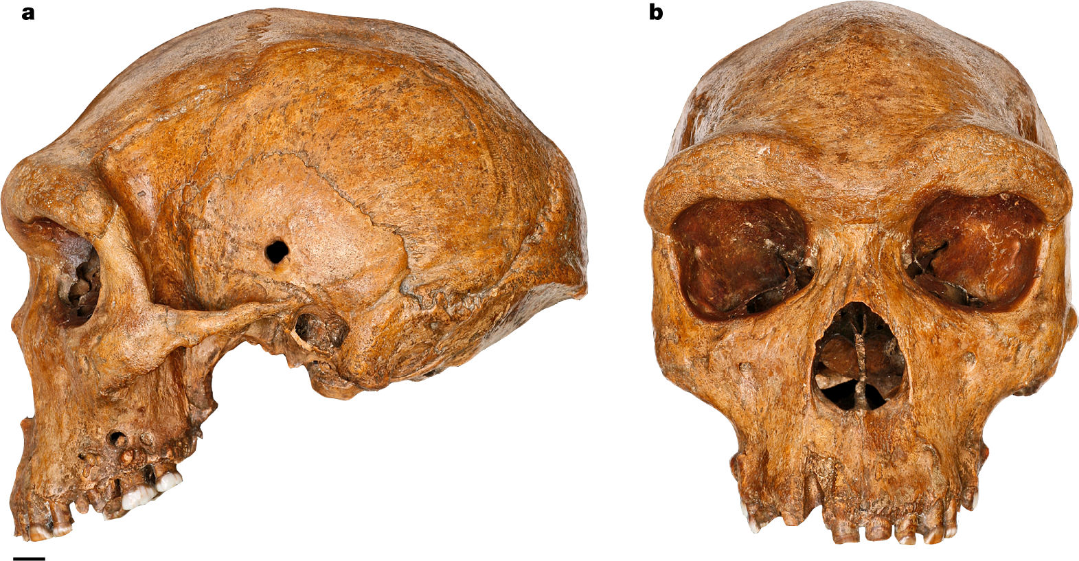
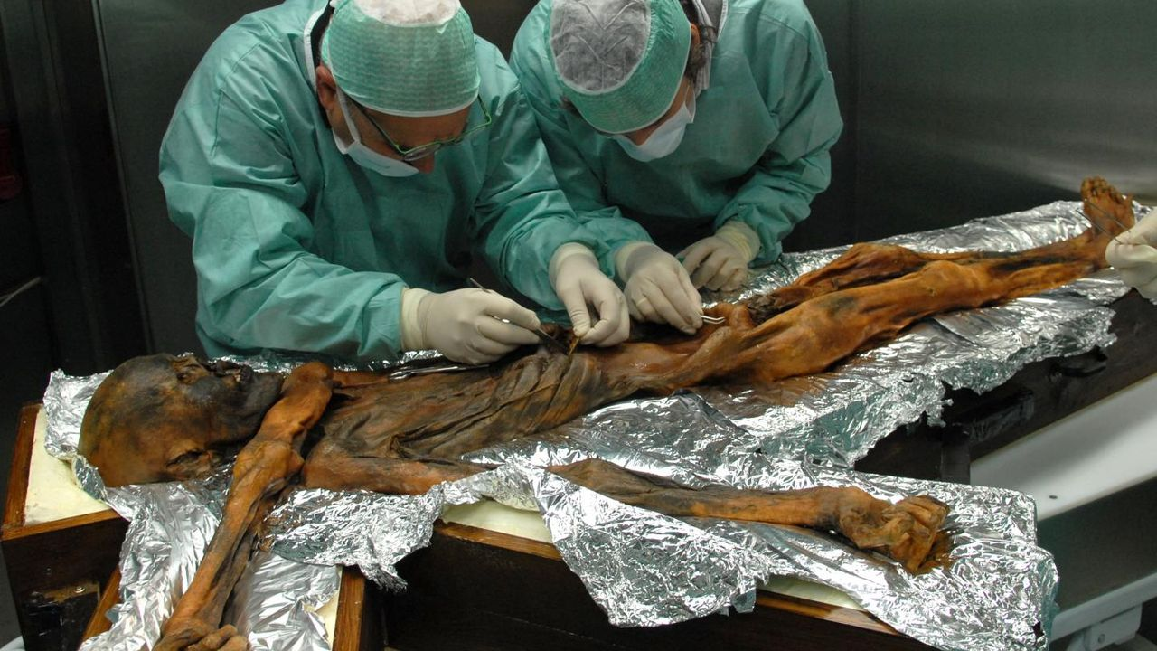
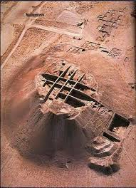
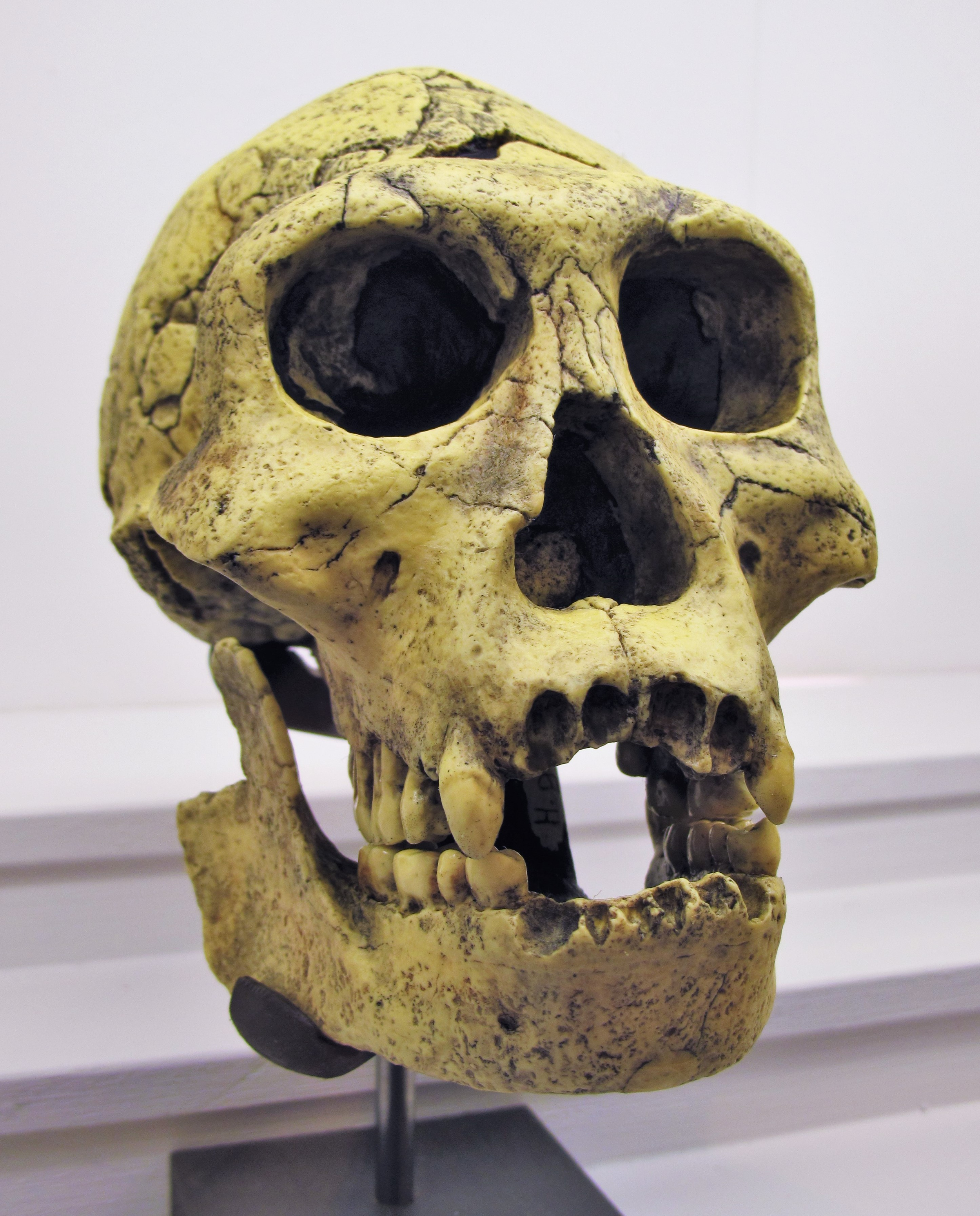
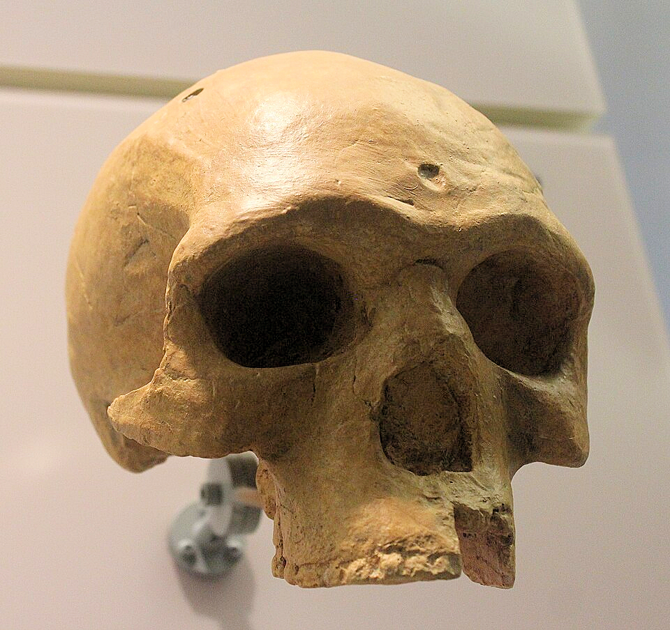
Discovered in 1932 by T.F. Dreyer at the Florisbad thermal spring site in the Free State Province, South Africa, the Florisbad Skull (cataloged as Florisbad 1) is an indispensable, highly controversial fossil puzzle piece. Consisting of a partial cranium featuring a remarkably well-preserved right face, an extensive frontal bone, and segments of the braincase walls, this fossil exhibits a classic "mosaic" configuration that continues to test the boundary lines between late archaic humans and the absolute earliest dawn of our own species.

   [ ARCHIC REGIONAL ANCESTRY ] ──► Archaic Homo heidelbergensis Trait Baseline
                                                 │
                                      (The Evolutionary Drift)
                                                 │
                                                 ▼
   [ RE-CLASSIFIED ENDPOINT ] ◄──── Early "Archaic" Homo sapiens Core (260,000 YA)

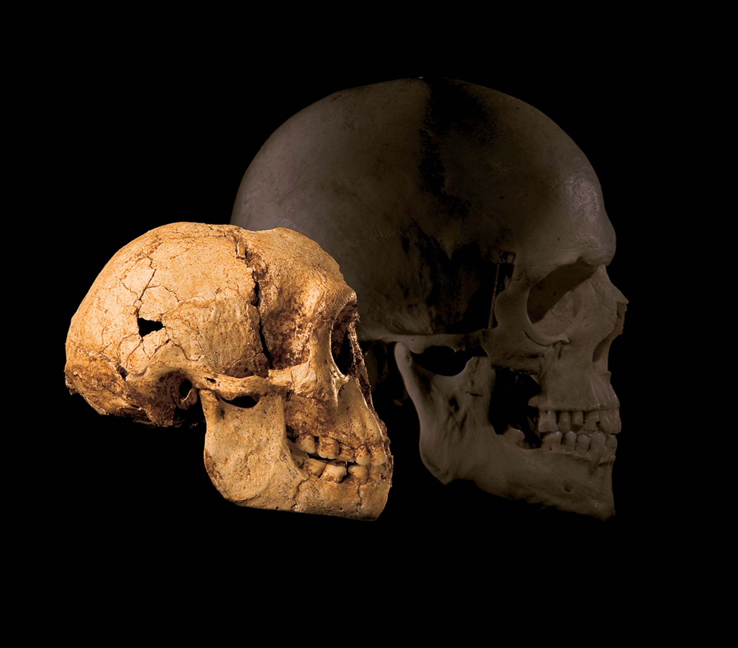
The Mosaic Architecture

The Florisbad skull refuses to fit cleanly into any single taxonomic box because its structural traits are split between two distinct evolutionary worlds:

  • The Modern Frontal Architecture: The forehead and frontal squama display a pronounced, modern-like curvature and vertical bulging. The spatial relationship between the face and the frontal lobes directly mimics the orientation seen in modern Homo sapiens, eliminating the flat, low slope characteristic of Homo erectus.

  • The Archaic Parietal Flattness: In sharp contrast, the parietal regions (the top and sides of the head) are flat, low, and elongated. Furthermore, the frontal lobes are exceptionally broad, displaying a lateral widening that shares surprising affinity with the robust cranial architecture of Neanderthals and Homo heidelbergensis.

High-Precision Dating and Environmental Taphonomy

The antiquity of the Florisbad cranium was anchored to $259,000 \pm 35,000$ years ago using direct electron spin resonance (ESR) dating applied to an intact upper right third molar found alongside the skull fragments.

Taphonomic analysis of the bone surfaces revealed a dark history: the skull fragments show clear, distinct hyena puncture marks and chewing scars, indicating that this early human likely fell victim to a large Pleistocene carnivore, with their remains washed into the churning, mineral-rich vertical vents of an active thermal spring.

The Reclassification as Early Homo Sapiens

For decades, the skull was assigned its own independent species name, Homo helmei, to denote its intermediate status. However, following the 2017 re-dating of the Jebel Irhoud fossils to 300,000 years ago, a strong scientific consensus emerged among world-leading paleoanthropologists.

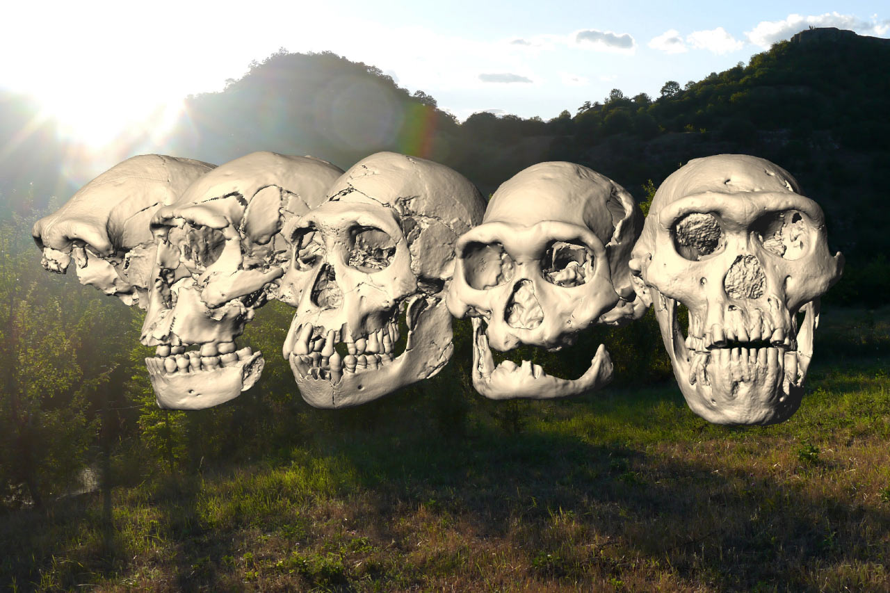
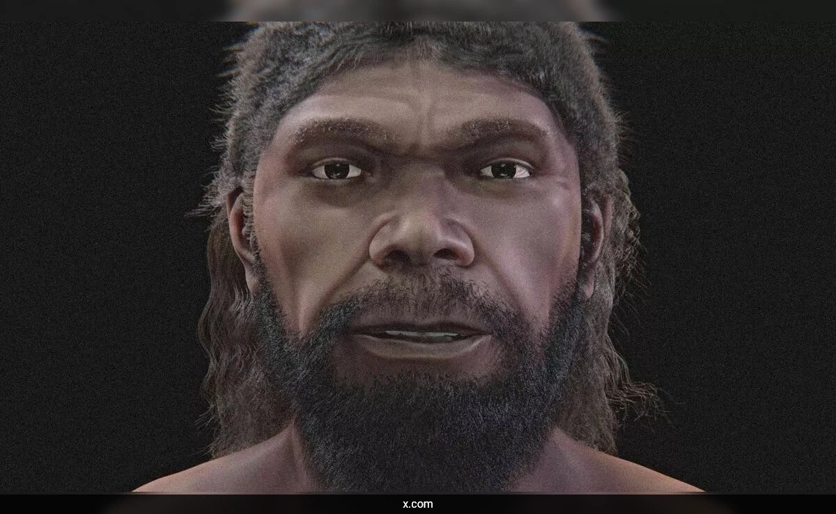
The Florisbad skull is now widely classified alongside Jebel Irhoud as an authentic, critical representative of early or "archaic" Homo sapiens. Positioned at roughly 260,000 years old, Florisbad represents the southern vanguard of our species' early diversification, confirming that our early ancestors were already morphologically diverse and widely distributed across the entire length of the African continent.

Dmanisi Skulls: Georgia's 1.8 Million-Year-Old Toolmakers

June 20, 2026

Situated on a high, wind-swept volcanic promontory in southern Georgia, the site of Dmanisi stands as the absolute foundational gateway of the human diaspora out of Africa. Excavations at the site recovered a flawless taphonomic sample: five extraordinarily well-preserved hominin skulls, complete postcranial skeletons, primitive stone tools, and thousands of extinct animal bones, all securely sealed beneath a basalt lava layer dated precisely to 1.85 million years ago. This site represents the earliest, indisputable evidence of primitive humans living outside the African continent.

                    [ THE DMANISI INTRAPOPULATION MATRIX ]
                                       │
         ┌─────────────────────────────┼─────────────────────────────┐
         ▼                             ▼                             ▼
[ SKULL 2 (D2282) ]           [ SKULL 4 (D3444) ]           [ SKULL 5 (D4500) ]
* Gracile, youth profile      * Completely edentulous       * Hyper-robust massive jaw
* Small 650 cc brain volume   * Survived years without teeth* Ultra-primitive 546 cc vault
* Classic H. ergaster trait   * High-density social care    * Resembles H. habilis/rudolfensis

The Variation Shockwave: Skull 5

The morphological variation contained within this single, synchronous paleodemographic population sent shockwaves through paleoanthropology, most notably with the discovery of Skull 5 (D4500) paired with its massive mandible (D2600). Skull 5 is an astonishing anatomical hybrid:

  • The Vault vs. The Face: It possesses the smallest, most primitive neurocranium of the entire cohort, measuring a tiny 546 cubic centimeters ($546\text{ cm}^3$), a brain volume barely larger than a chimpanzee's. Yet, this tiny braincase is anchored to a massive, projecting, and hyper-robust face with an enormous jaw and large chewing teeth.

If these five skulls had been discovered in different geographic regions or distinct stratigraphic layers across Africa, they would have inevitably been classified as completely separate species—some designated as Homo habilis, others as Homo ergaster or Homo erectus.

Because they were found together in the same mud layer within the same collapsed cave chamber, they prove they belong to a single, highly variable population of early Homo erectus. This discovery single-handedly suggests that many named early human species may simply be natural variations within a single, highly diverse evolutionary lineage.

The Survival of the Toothless: Ancient Altruism

Beyond the taxonomic implications, Dmanisi provided the world’s earliest, deeply moving evidence of advanced social empathy and hominin altruism in the form of Skull 4 (D3444). This individual was completely edentulous—they had lost all their teeth years before their death, and the jawbone had completely resorbed and healed over.

In a brutal, predator-dominated Pleistocene landscape 1.8 million years ago, a toothless human could not chew raw meat, strip vegetation, or manufacture tools with their mouth.

The survival of Skull 4 for several years without teeth proves that the Dmanisi group must have actively supported this vulnerable individual—likely by cooking food, pre-masticating soft meat for them, and protecting them from the giant saber-toothed cats (Megantereon) whose bones litter the cave floor. Long before the evolution of a large brain, humanity’s ultimate survival strategy was already deep-layer social cooperation.

Broken Hill Skull: Zambia's 300,000-Year-Old Survivor

June 20, 2026

Discovered accidentally in 1921 during zinc mining operations in Kabwe, Zambia, the Broken Hill Skull (cataloged as Kabwe 1) is one of the most magnificent, intimidating, and structurally complete fossil craniums ever recovered from the African Middle Pleistocene. Initially classified speculatively as Homo rhodesiensis, this massive skull is now widely recognized as a classic, hyper-robust representative of Homo heidelbergensis (or a closely related archaic African lineage), providing a vital look at the stocky, heavy-browed ancestral populations that occupied Africa concurrently alongside the emergence of early Homo sapiens.

[ ARCHAEOLOGICAL ASSUMPTION ] ──► Early Middle Pleistocene (~500,000 YA)
                                            │
                             (U-Series Direct U-Th/ESR Scan)
                                            │
                                            ▼
[ CHRONOLOGICAL TRUTH ] ────────► 299,000 ± 25,000 YA: Late Archaic Survivor

Hyper-Robust Morphological Features

Kabwe 1 is the anatomical antithesis of Jebel Irhoud. It exhibits an extreme suite of primitive, robust features that reflect an immense physical investment in skull structural integrity and muscle attachment:

  • The Supraorbital Torus: The skull features the largest, thickest, and most prominent brow ridge of any hominin fossil ever discovered, forming an unbroken, massive shelf of solid bone over the eye orbits.

  • The Cranial Vault: The braincase is long, low, and thick-walled, featuring a pronounced occipital torus (a bony ridge at the back of the skull) to anchor massive neck muscles. However, despite its primitive architecture, the brain size is surprisingly large, measuring roughly 1,280 cubic centimeters ($1280\text{ cm}^3$), well within the lower volume threshold of living humans.

Redating an Enigma

For nearly a century, the exact age of the Broken Hill Skull was impossible to verify because the mining operations completely blasted away the original cave site, destroying its stratigraphic context. Early estimates guessed an age of 500,000 to 700,000 years old, positioning it safely as a distant, ancient ancestor.

However, a high-precision, direct-dating project applied advanced Uranium-series (U-Th) and Electron Spin Resonance (ESR) dating directly to the skull fragments and associated faunal remains.

The results provided a startlingly young age of $299,000 \pm 25,000$ years old. This timeline means that Kabwe 1 was not a distant, isolated primitive ancestor; it was a late-surviving contemporary.

While early Homo sapiens with modern faces were actively hunting across Morocco and East Africa, this massive, hyper-robust Homo heidelbergensis morphotype was still actively surviving in Southern Africa, demonstrating that the African Middle Pleistocene was an evolutionary landscape crowded with diverse, overlapping human species.

Jebel Irhoud: Morocco's 300,000-Year-Old Modern Face

June 20, 2026

Jebel Irhoud: Morocco's 300,000-Year-Old Modern Face

For decades, the textbook narrative of human evolution placed the cradle of anatomically modern Homo sapiens firmly in East Africa (specifically Ethiopia) around 200,000 years ago. However, groundbreaking multi-disciplinary excavations at the desert site of Jebel Irhoud, located just 100 kilometers western of Marrakesh, Morocco, completely shattered this linear model. The site yielded the remains of at least five individuals directly dated to approximately 300,000 years ago, shifting both the timeline and the geography of our species' origins.

                  [ JEBEL IRHOUD CRANIAL MOSAIC ]
                                 │
         ┌───────────────────────┴───────────────────────┐
         ▼                                               ▼
[ THE ANTERIOR MODERN FACE ]                   [ THE POSTERIOR BRAINCASE ]
* Retracted, delicate cheekbones               * Elongated, archaic globular shape
* Modern orthnathic profile                    * Low, sloping frontal bone
* Indistinguishable from living humans          * Lacks modern parietal expansion

The Morphological Mosaic

What makes the Jebel Irhoud fossils revolutionary is their stark, evolutionary anatomical dichotomy. They do not represent a fully formed "modern" human, but rather an evolutionary snapshot of our lineage in transition:

  • The Modern Face: If you were to see a Jebel Irhoud individual wearing a modern hat, you would not notice any difference. The face is entirely anatomically modern. It features a retracted, short, and delicate facial profile (orthognathic) with small cheekbones and a brow ridge structure that directly anticipates living populations.

  • The Archaic Braincase: The moment the hat is removed, the illusion fades. The neurocranium (braincase) remains deeply primitive. It is elongated, low, and archaic (dolichocephalic), lacking the tall, globular, balloon-like vault and expanded parietal lobes that characterize modern human brains.

High-Precision Thermoluminescence Dating

The extraordinary antiquity of the Jebel Irhoud hominins was secured using advanced Thermoluminescence (TL) dating applied to heated stone tools found in direct stratigraphic alignment with the human bones. Flints that had been accidentally dropped into ancient campfires by the hominins had their internal "atomic clocks" reset by the heat.

By measuring the accumulated radiation dose in these flints since they were last heated, physicists established an airtight age matrix centering on $315,000 \pm 34,000$ years ago. This absolute timeline was independently confirmed via Electron Spin Resonance (ESR) testing on a human tooth from the site.

The Pan-African Evolution Model

Jebel Irhoud effectively dismantled the "Single Eden" theory of human origins. The presence of these early Homo sapiens in North Africa, possessing modern faces but archaic brains, proves that our speciation was not a sudden localized event in an East African valley.

Instead, it was a pan-African phenomenon. Our species evolved across a highly interconnected, continent-wide network of diverse populations that exchanged genes and behavioral technologies across a green, wet Sahara, gradually patching together the mosaic of features that define modern humanity today.

Homo Luzonensis: Philippines' Hobbit-Like Cave Dwellers

June 20, 2026

In 2019, an international team of scientists led by Dr. Armand Salvador Mijares made an announcement that permanently shattered the long-held paradigm of Southeast Asian paleoanthropology: the discovery of a completely new species of ancient human named Homo luzonensis.

Unearthed deep within the stratigraphic layers of Callao Cave on the northern island of Luzon in the Philippines, these fossils—dating back between 50,000 and 67,000 years ago—proved that island Southeast Asia was an evolutionary laboratory of endemic, bizarre human experimentation.

[ ARCHITECTURAL LANDSCAPE ] ──► Deep Island Isolation of Luzon (Barred by Deep Water)
                                           │
                               (Endemic Evolutionary Trajectory)
                                           │
                                           ▼
[ MORPHOLOGICAL MOSAIC ] ◄──── Ancient Curved Australopithecus Foot + Modern Human Teeth

The Morphological Mosaic

The discovery of Homo luzonensis was based on a highly specific assemblage of skeletal remains, including hand and foot bones, thigh bone fragments, and a collection of adult teeth representing multiple distinct individuals. When physical anthropologists subjected these tiny bones to high-resolution micro-CT scanning and comparative morphological testing, they discovered a stunning, unprecedented "mosaic" of primitive and derived features:

  • The Australopithecus Foot: Most shockingly, the third metatarsal (foot bone) of Homo luzonensis is highly curved and morphologically identical to the foot structures of ancient Australopithecus species (like Lucy) who lived in Africa over 3 million years prior. This curved foot bone is an explicit adaptation for arboreal climbing, indicating that this island human spent a significant portion of its life navigating the forest canopies.

  • The Modern Teeth: In stark contrast to the incredibly primitive foot, the premolar and molar teeth of Homo luzonensis are exceptionally small and compact, sharing highly derived, simplified traits that mimic the dental morphology of modern Homo sapiens.

The Island Laboratory: Insular Dwarfism

How did a hominid possessing 3-million-year-old primitive climbing traits live concurrently alongside modern humans just 50,000 years ago? The answer lies in the intense evolutionary pressure of insular dwarfism:

Luzon has always been an isolated ocean island, completely surrounded by deep-water marine trenches. Even during periods of extreme low sea levels during the last Ice Age, Luzon was never connected to mainland Asia by a dry land bridge.

To arrive on the island, the ancestral lineage of Homo luzonensis—likely a group of adventurous Homo erectus sailors—had to cross deep maritime straits on primitive watercraft or survive an accidental rafting event caused by a tsunami.

Once trapped on the island, the population adapted to limited food resources and a lack of large apex predators. Just like Homo floresiensis (the famous "Hobbit" of Flores Island), Homo luzonensis systematically shrank in size over generations, evolving into a diminutive, small-statured human who re-evolved primitive climbing structures to effectively exploit the vertical ecology of the tropical rainforest canopy, proving that the human evolutionary story is far more diverse and unpredictable than science ever suspected.

Denisova Cave: Hybrid Human Fossils Rewrite Evolution

June 20, 2026

Deep in the Altai Mountains of Siberia, Denisova Cave has earned a legendary status as the ultimate chronological crucible of human evolution. In 2010, the Max Planck Institute for Evolutionary Anthropology shocked the scientific world by extracting DNA from a tiny finger bone, revealing an entirely new, distinct branch of the human family tree: the Denisovans.

However, subsequent deep-layer excavations and high-resolution paleogenomic mapping inside the cave have yielded an even more radical discovery—the recovery of physical, first-generation hybrid human fossils that have permanently dismantled the traditional "linear" model of human evolution.

                  [ THE HOMINID ADMIXTURE MATRIX ]
                                  │
       ┌──────────────────────────┴──────────────────────────┐
       ▼                                                     ▼
[ DENISOVAN MATERNAL LINE ]                         [ NEANDERTHAL PATERNAL LINE ]
* High-altitude adapted genome                     * Western European migratory branch
* Deep Altai cave lineage                          * High-density cold climate physiology
       │                                                     │
       └──────────────────────────┬──────────────────────────┘
                                 ▼
           [ THE HYBRID ENDPOINT: "Denny" (Denisova 11) Confirmed ]

The Discovery of "Denny" (Denisova 11)

The crown jewel of this evolutionary paradigm shift is a single, non-descript 2.5-centimeter bone fragment cataloged as Denisova 11, affectionately known to geneticists as Denny.

Using an innovative technique called ZooMS (Zooarchaeology by Mass Spectrometry), which identifies species by analyzing the unique collagen protein sequences within thousands of unidentifiable bone splinters, researchers flagged the bone as hominid.

When the nuclear genome of Denisova 11 was completely sequenced, the data revealed an anthropological miracle: Denny was a first-generation, 50/50 hybrid human child. She was a 13-year-old girl who lived approximately 90,000 years ago, born to a Neanderthal mother and a Denisovan father.

Mapping the Intricate Kinship Lines

Denny’s genome provided an unprecedented, high-definition look into the fluid dynamics of ancient hominid interactions:

  • The Maternal Line: Denny’s Neanderthal mother was genetically closer to the Neanderthals who lived thousands of miles away in Western Europe (such as Vindija Cave in Croatia) than to the ancient Neanderthals who had occupied Denisova Cave thousands of years prior. This proved that Neanderthals engaged in massive, long-distance migratory sweeps across Eurasia.

  • The Paternal Line: Denny’s Denisovan father was a local Altai Denisovan, but his genome also carried deep, ancestral traces of a much older, minor Neanderthal admixture layer from an entirely separate encounter hundreds of generations earlier.

Dismantling the Isolated Species Myth

Before these paleogenomic breakthroughs, classic evolutionary biology frequently visualized human evolution as a straight line, or a tree with cleanly separated, isolated branches representing distinct species (Homo sapiens, Homo neanderthalensis, and Denisovans) that occasionally, accidentally bumped into one another.

The discovery of a first-generation hybrid like Denny proves that when ancient hominid groups encountered one another in the wild, they did not view each other as separate species; they mated, integrated, and formed complex social kinship networks. Human evolution was not an array of isolated branches, but a highly complex, braided stream of genetic exchange, where our modern genome is the combined reservoir of multiple lost ancestral empires.

Ötzi the Iceman: Stomach Analysis Reveals Diet Shocker

June 20, 2026

When Ötzi the Iceman—a beautifully preserved 5,300-year-old glacier mummy—was discovered sticking out of the alpine ice on the Austro-Italian border in 1991, he became an instant scientific sensation. For decades, researchers subjected his hair, clothes, and bones to exhaustive analysis. However, a major anatomical mystery remained: his actual stomach appeared to be missing on early CT scans.

It wasn't until a comprehensive re-examination of his internal thoracic cavity that radiologists discovered his stomach had migrated upward into his chest cavity as his body naturally mummified under the crushing weight of the glacier.

The subsequent extraction and meticulous molecular analysis of his true stomach contents delivered an absolute dietary shock to paleonutritionists.

[ PRE-ANALYSIS ASSUMPTION ] ──► Lean, Spartan, Neolithically Cleansed Forager Diet
                                            │
                                (High-Definition Biomarker Scan)
                                            │
                                            ▼
[ MOLECULAR TRUTH ] ──────────► 46% Pure Adipose Fat: High-Velocity Glacier Fuel

The Molecular Reconstruction of the Last Meal

Using a cutting-edge combination of shot-gun metagenomics, microscopic macroremain analysis, and stable isotope tracking, scientists successfully reconstructed the final hours of Ötzi's life through his digestive tract.

The analysis proved that approximately 30 to 120 minutes before his violent murder on the high mountain pass, Ötzi sat down to a highly deliberate, exceptionally energy-dense meal:

  • The High-Fat Bomb: To the shock of researchers, up to 46% of the total stomach content was composed of pure animal fat. This was not lean meat; it was highly concentrated, greasy adipose fat derived from the Alpine ibex (Capra ibex) and red deer (Cervus elaphus).

  • The Ancient Grain Base: This massive dose of wild animal fat was paired with finely ground einkorn wheat (Triticum monococcum), one of the oldest domesticated grains of the European Neolithic. The presence of charred bran fragments suggests the grain was consumed not as a wet porridge, but as a dense, hard-baked unleavened flatbread.

  • The Toxic Medicinal Accompaniment: Most bizarrely, the analysis detected significant quantities of spores and tissue from the bracken fern (Pteridium aquilinum), an incredibly toxic, carcinogenic plant. Scientists hypothesize that Ötzi was intentionally consuming this poison as a form of primitive medicine to treat the severe human whipworm (Trichuris trichiura) infestation actively documented in his colon, using the toxic plant to paralyze the intestinal parasites.

Reworking the Neolithic Diet Paradigm

The extreme fat content of Ötzi's stomach fundamentally disrupted our understanding of prehistoric human survival mechanics. For decades, archaeologists envisioned the European Chalcolithic diet as a spartan, lean, and highly unstable agricultural existence.

Ötzi's last meal proved that high-altitude copper-age hunters possessed a sophisticated, intuitive mastery of human thermodynamics.

They understood that to survive, travel, and hunt in a freezing, sub-zero alpine environment at 3,200 meters above sea level, a human cannot rely on lean protein or simple carbohydrates. They required a high-velocity, slow-burning caloric engine fueled by pure, unrendered wild fat, transforming our view of prehistoric nutrition from accidental foraging to deliberate, high-performance survival engineering.

Genetic Ghosts: DNA Links Modern Greeks to Minoans

June 20, 2026

For over a century, the origins of the Bronze Age Minoan civilization (c. 2600–1100 BCE) on the island of Crete were shrouded in intense archaeological controversy. Sir Arthur Evans, the British archaeologist who unearthed the magnificent Palace of Knossos, famously hypothesized that the Minoans were a displaced, elite elite population from North Africa or the Middle East, arguing that their highly sophisticated architecture, vibrant frescoes, and advanced maritime trade networks were too complex to have developed from the local Aegean population.

However, modern paleogenomics has decisively corrected this assumption, uncovering a profound genetic continuity that links the ancient builders of the Labyrinth directly to the modern inhabitants of Greece.

                         [ THE AEGEAN GENETIC PIPELINE ]
                                       │
         ┌─────────────────────────────┴─────────────────────────────┐
         ▼                                                           ▼
 [ ANCIENT NEOLITHIC BASELINE ]                            [ LATER BRONZE AGE INPUTS ]
 * Western Anatolian Farmers (~75% Core)                  * Caucasus / Iranian Admixture
 * Aegean Indigenous Foragers                             * Northern Steppe (Mycenaean Only)
         │                                                           │
         └─────────────────────────────┬─────────────────────────────┘
                                      ▼
             [ GENETIC ENDPOINT: High Continuity in Modern Greeks ]

The Archaeogenetic Extraction

To solve this historical enigma, an international coalition of geneticists and archaeologists harvested and mapped genome-wide data from ancient skeletons recovered from Minoan tombs across Crete, Mycenaean burials on the Greek mainland, and Bronze Age remains from southwestern Anatolia.

Despite the notoriously poor preservation of ancient DNA (aDNA) in the warm, humid climate of the Mediterranean, researchers successfully isolated high-quality nuclear DNA from the petrous bone of the inner ear, providing an uncompromised genetic snapshot of the Bronze Age Aegean.

The Ancestral Blueprint

The paleogenomic results revealed a highly localized, distinct ancestry profile that rewrote Aegean prehistory:

  • The Neolithic Core: The data proved that the Minoans were not foreign invaders. They derived at least three-quarters ($75\%$) of their genetic ancestry directly from the first Neolithic farmers who had migrated from Western Anatolia and the Aegean islands thousands of years prior. They were, genetically speaking, indigenous locals who evolved in place.

  • The Eastern Admixture: The remaining quarter of Minoan ancestry showed a distinct genetic signature linked to ancient populations from the Caucasus and Iran. This indicates a previously unrecorded, prehistoric migration event across the Mediterranean corridor during the 4th-2nd millennium BCE, bringing new cultural and genetic layers to Crete without erasing the native population.

The Mycenaean Divide and Modern Continuity

The study also analyzed the Mycenaeans of mainland Greece—the militaristic society celebrated in Homer’s Iliad. The genetic data revealed that while Mycenaeans and Minoans were incredibly close cousins sharing the same basic Anatolian-Caucasus genetic foundation, the Mycenaeans possessed a critical genetic difference: they carried an additional $4\% \text{ to } 16\%$ of ancestry derived from Eastern European and Siberian hunter-gatherers, introduced via pastoralists from the Eurasian steppe.

When geneticists compared these ancient Bronze Age profiles to modern populations, the results were striking. Modern Greeks are genetically bound directly to these Bronze Age civilizations. While the modern Greek genome shows subtle dilution and subsequent admixture with later historical migrations through the Balkans and the Mediterranean, the foundational core remains heavily anchored to the Mycenaean and Minoan baselines. The Greeks, as paleogenomicists note, have been a genetic "work in progress" for millennia, adding new layers of cultural and biological migration without ever erasing the genetic ghosts of Europe's first literate societies.

2026 AI Scans: Rediscovering Amazon's Lost Geoglyphs

June 20, 2026

2026 AI Scans: Rediscovering Amazon's Lost Geoglyphs

For decades, the dense, multi-tiered canopy of the Amazon rainforest acted as an impenetrable green wall, concealing the monumental earthworks of a highly advanced, pre-Columbian civilization. Historically, discovering these ancient earthworks required sheer luck, visual scouting following clear-cutting, or localized, expensive airborne radar sweeps.

In 2026, a revolutionary leap occurred with the deployment of advanced object-detection machine learning frameworks—most notably systems like GlyphTrack—designed specifically to scan vast, multi-country tracts of Amazonian wilderness.

   [ ORBITAL DATA PIPELINE ] ──► NASA GEDI (Spaceborne LiDAR Profile)
                                            │
                                (AI Micro-Relief Filtration)
                                            │
                                            ▼
   [ REVEALED CIVILIZATION ] ◄── High-Probability Geoglyph Matrix Confirmed

The Technology: Piercing the Green Canopy

The 2026 breakthrough relies on combining spaceborne LiDAR (Light Detection and Ranging) data, specifically from NASA's GEDI (Global Ecosystem Dynamics Investigation) instrument mounted on the International Space Station, with high-resolution digital elevation models (DEMs).

While raw satellite images see only an unbroken ocean of green leaves, LiDAR shoots billions of laser pulses through the canopy. A fraction of these pulses slip between branches, bouncing directly off the forest floor.

The true innovation lies in the AI processing layer:

  • Micro-Relief Detectors: Machine learning models use robust regression techniques (like RANSAC) to calculate the precise relationship between tree canopy height and true ground elevation. The AI effectively "digitally deforests" the data, isolating subtle, man-made ground anomalies.

  • Positive-Unlabeled (PU) Bagging: Because archaeologists have only mapped a tiny fraction of the Amazon, the AI models are trained on partial datasets. The system analyzes known positive geoglyphs, learns their precise geometric signatures, and then applies predictive gradient-boosting frameworks (like LightGBM) to search millions of square kilometers of unmapped wilderness for identical archaeological signatures.

The Revealing of a Garden City Civilization

The 2026 AI sweeps have fundamentally shattered the long-held Eurocentric myth of the Amazon as a "pristine, untamed wilderness" historically populated only by small, nomadic hunter-gatherer groups. Instead, the data reveals a highly structured, anthropogenically modified landscape:

  • Geometric Earthworks: The AI scans have exposed hundreds of new geoglyphs—massive, precision-engineered ditches and raised berms forming perfect circles, concentric squares, and complex hexagons ranging up to 300 meters in diameter.

  • Connected Urbanism: Crucially, these geoglyphs do not sit in isolation. The AI models have mapped vast networks of wide, straight, elevated causeways (highways) that interlink distinct geoglyph complexes across tens of miles, winding around managed freshwater canals and massive artificial fish ponds.

These discoveries prove that between 1000 BCE and 1500 CE, the southwestern Amazon basin—particularly the Acre region of Brazil and the borders of Bolivia—was home to a dense, interconnected "garden city" civilization. These societies actively managed their biosphere, moving millions of tons of earth to construct ceremonial plazas, defensive outposts, and agricultural hubs long before the first European footprints touched the Americas.

Lake Titicaca: Tiwanaku's Sunken Reed Islands and Sacred Offerings

June 18, 2026

Perched high in the Andes mountains on the border of Peru and Bolivia, sitting at an altitude of 12,500 feet above sea level, Lake Titicaca is the highest navigable body of water in the world. To the ancient civilizations of the Andes—most notably the Tiwanaku empire (c. 500–1000 CE) and the later Inca Empire—Lake Titicaca was the absolute center of the cosmos. According to Andean creation myths, it was from the icy depths of this lake that the god Viracocha emerged to create the Sun, the Moon, and the first human beings.

                         [ TITICACA SACRED GEOGRAPHY ]
                                       │
         ┌─────────────────────────────┴─────────────────────────────┐
         ▼                                                           ▼
 [ INDIGENOUS UROS BIOSPHERE ]                             [ RECENT SUB-SURFACE DISCOVERIES ]
 Floating *totora* reed island ecosystems                   Sacrificial gold/silver llama statuettes
         │                                                           │
         └─────────────────────────────┬─────────────────────────────┘
                                      ▼
               [ RITUAL CORE: Submerged Santiago de Ojje Reef ]

The lake operates a fascinating dual architectural ecosystem: above the waves, the indigenous Uros people have maintained a continuous, millennia-old tradition of constructing entire living cities out of woven totora reeds, building floating artificial islands that can support houses, schools, and watchtowers. Meanwhile, deep beneath the surface sits a sprawling archive of stone structures and elite religious offerings that are rewriting the history of pre-Inca state power.

The Submerged Temples of the Khoa Reef

In the early 2000s, international underwater archaeological expeditions led by the Akakor Geographical Exploring team and Oxford University began systematic scuba and sonar surveys around the isolated Khoa and Santiago de Ojje reefs within the lake. Submerged beneath 20 to 30 feet of water, teams discovered massive, man-made stone walls, paved paths, and terrace structures that had been inundated over centuries due to shifting high-altitude precipitation patterns.

More important than the architecture were the breathtaking ritual artifacts preserved in the ultra-cold, low-oxygen lake water. For centuries, Tiwanaku and Inca priests sailed out to the center of the lake to drop elite offerings directly into the water:

  • The Llama Sculptures: Divers recovered dozens of tiny, exquisitely carved ceremonial box containers fashioned from rare Spondylus sea shells and solid silver, containing miniature figurines of llamas and alpacas hammered out of pure gold leaf.

  • The Ritual Ceramics: Teams extracted hundreds of intact Tiwanaku ceramic incense burners (incensarios) shaped like stylized jaguars, painted with intricate geometric slips and filled with residues of burned psychoactive resins.

  • Animal Sacrifices: The presence of juvenile llama skeletons alongside elite gold jewelry suggests that the lake floor was a permanent, sacred repository for complex propitiation rituals designed to stabilize the volatile Andean climate.

These underwater discoveries prove that long before the Inca established their empire, the Tiwanaku state was deploying highly advanced maritime technology to transform Lake Titicaca into a centralized, watery cathedral, binding the elite wealth of the Andes directly to the sacred memory of the water.

Bimini Road: Bahamas' Atlantis-Linked Underwater Stones

June 18, 2026

Located just off the coast of North Bimini Island in the Bahamas, resting in approximately 15 feet of crystal-clear Atlantic water, lies the Bimini Road (sometimes called the Bimini Wall). This striking underwater feature consists of a 0.8-kilometer-long, J-shaped linear track composed of massive, flat, roughly rectangular limestone blocks that appear to be neatly arranged like a paved highway or a defensive harbor wall on the ocean floor.

   [ MYTHOLOGICAL CATALYST ] ──► Edgar Cayce's 1938 Atlantis Prophecy
                                            │
                                (The 1968 Discovery)
                                            │
                                            ▼
   [ GEOLOGICAL ANALYSIS ] ◄──── Beachrock Tessellation via Natural Jointing

The site sparked an international sensation when it was discovered in 1968 by marine scientists. To many, it appeared to be the definitive confirmation of a famous prophecy made by American mystic Edgar Cayce in 1938. Cayce had explicitly predicted that the ruins of the lost continent of Atlantis would be rediscovered in the waters around Bimini between 1968 and 1969.

The apparent alignment of this prophecy with the discovery of a seemingly engineered stone road triggered decades of fringe archaeological speculation, attracting alternative historians who argued that the stones were part of a prehistoric temple complex or an ancient Phoenician harbor installation.

The Scientific Deconstruction

Because the site represents a significant case study in pseudo-archaeology, professional geologists and marine scientists have subjected the Bimini Road to intense physical and chemical testing. The results have gently but decisively corrected the myth, proving that the Bimini Road is an entirely natural geological formation:

  • Beachrock Tessellation: The road is composed of a specific type of limestone known as beachrock, which forms rapidly beneath the sand along coastal shorelines due to the precipitation of calcium carbonate cements.

  • Natural Jointing: As the shoreline recedes or undergoes tectonic flexing, the brittle beachrock fractures along highly uniform, straight lines known as joints. Over centuries, internal currents and wave action erode these cracks, smoothing the edges of the individual slabs and making them look like hand-cut, rectangular paving blocks.

  • The Stratigraphic Proof: Core drilling samples through the Bimini stones revealed that the internal bedding planes of the rock run continuously from one block to the next. If humans had cut and laid these stones, the internal geological layers would be completely randomized.

Furthermore, micro-fossils and radiocarbon dating within the stone matrix confirm that the rock formed naturally on the Bahamian shelf roughly 2,000 to 3,500 years ago—long after any theoretical date for Atlantis. The Bimini Road remains a stunning underwater destination, not as a monument to a lost empire, but as a masterclass in nature's ability to mimic the precision of human engineering.

Doggerland: Europe's Drowned Mesolithic Paradise

June 18, 2026

Ten thousand years ago, a human traveler could walk from the rolling hills of modern-day Yorkshire in Great Britain across a vast, fertile plain all the way to the coastlines of Denmark and the Netherlands without ever catching a glimpse of the ocean. This lost heartland of prehistoric Europe is known to modern archaeologists as Doggerland, a sprawling landmass that once covered over 180,000 square kilometers beneath what is now the cold, turbulent waters of the North Sea.

                  [ THE MESOLITHIC EVOLUTION OF DOGGERLAND ]
                                      │
                                      ▼
   [ UN-DAMMED PARADISAL STEPPE ] ──► Rich Estuaries, Rivers, & Mammoths (c. 9000 BCE)
                                      │
                                      ▼
   [ SEA LEVEL INUNDATION ] ───────► Glacial Melt Shrinks Land Into Islands (c. 7000 BCE)
                                      │
                                      ▼
   [ THE STOREGGA SLIDE ] ─────────► Massive Submarine Tsunami Seals the Basin (c. 6200 BCE)

Doggerland was not a secondary land bridge; it was the absolute ecological paradise of Mesolithic Europe. Fed by the prehistoric channels of the Rhine and Thames rivers, Doggerland was a rich tapestry of winding estuaries, massive freshwater lagoons, dense oak forests, and sweeping marshlands. It supported an immense concentration of wildlife, including herds of woolly mammoths, reindeer, wild boar, and red deer, making it the premier hunting and fishing ground for nomadic Mesolithic hunter-gatherers.

The Treasures of the Trawlers

For over a century, the primary archaeologists of Doggerland were not scuba divers, but commercial North Sea fishermen. Since the late 19th century, deep-sea trawlers dragging heavy nets along the shallow sandbanks of the Dogger Bank have hauled up an astonishing collection of prehistoric artifacts from the ocean floor:

  • The Megafauna: Trawlers have recovered thousands of fossilized bones belonging to mammoths, woolly rhinoceroses, and cave lions.

  • The Tools: Fishermen have pulled up beautifully preserved Mesolithic flint tools, barbed harpoons carved from stag antlers, and polished bone tools wrapped in prehistoric plant fibers.

  • Human Remains: Several fossilized human skull fragments, dating back over 9,000 years, have been recovered, showing direct isotopic evidence of a diet rich in marine and wetland resources.

The Storegga Cataclysm

The destruction of Doggerland was a long-term tragedy punctuated by a sudden, apocalyptic climax. As the global climate warmed at the end of the last Ice Age, the massive Laurentide and Fennoscandian ice sheets melted, causing global sea levels to rise at a terrifying rate. Doggerland was systematically eaten away, transforming from a vast continental plain into a series of shrinking, low-lying islands.

The final death blow struck around 6200 BCE. Deep beneath the Norwegian Sea, a catastrophic submarine landslide known as the Storegga Slide occurred, causing over 3,000 cubic kilometers of coastal shelf to collapse into the deep ocean.

This massive displacement triggered a colossal tsunami that ripped across the North Sea. Waves exceeding 20 feet in height tore through the low-lying wetlands of remaining Doggerland, instantly drowning the remaining Mesolithic communities and permanently sealing this prehistoric paradise beneath the ocean, creating the modern English Channel and altering European human history forever.

Kumari Kandam: Lemuria's Lost Tamil Continent Evidence

June 18, 2026

The narrative of Kumari Kandam sits at a fascinating, complex crossroads where 19th-century Western scientific missteps collided with ancient Tamil literary traditions and modern cultural identity. According to classical Tamil Sangam literature dating back over two millennia, there once existed a massive, sprawling landmass extending south from the tip of modern India into the Indian Ocean.

This land, known as Kumari Kandam, was said to be the absolute cradle of Tamil civilization, home to legendary academies of poets (Sangams) and ruled by the ancient Pandyan dynasty for tens of thousands of years before it was completely devoured by a series of catastrophic ocean deluges (kadalkol).

   [ 19th-CENTURY Western Zoogeography ] ──► Sclater's "Lemuria" Land Bridge Hypothesis
                                                    │
                                        (The Tamil Cultural Fusion)
                                                    │
                                                    ▼
   [ MODERN GEOLOGICAL PARADIGM ] ◄────── Plate Tectonics Disproves Sunken Continent

The Western Origin: Sclater’s Lemuria

To understand the modern evolution of Kumari Kandam, one must analyze a defunct 19th-century scientific theory. In 1864, English zoologist Philip Sclater was puzzled by the presence of identical lemur fossils in Madagascar and India, but their complete absence in Africa and the Middle East. Before the discovery of plate tectonics and continental drift, Sclater hypothesized that a massive, sunken continent must have once connected India to Madagascar across the Indian Ocean. He named this theoretical land bridge Lemuria.

When Sclater’s hypothesis reached British-occupied India, Tamil scholars and revivalists noticed a striking correlation between the Western scientific concept of Lemuria and their own ancient literary records of the lost landmass swallowed by the sea. They adopted the term, mapping Lemuria directly onto Kumari Kandam, elevating it into a foundational narrative of their cultural history.

The Scientific Clarification

While Kumari Kandam remains a powerful cultural symbol of cultural pride, modern earth sciences have gently but firmly corrected the concept of a giant, sunken continent in the middle of the Indian Ocean:

Modern plate tectonics has definitively proven that a massive, intact continent could not have sunk into the Indian Ocean during human history. Satellites and oceanographic floor-mapping show no continental crust beneath the Indian Ocean basin—only basaltic oceanic crust, confirming that India and Madagascar separated via tectonic drift over 80 million years ago, long before the evolution of humans.

However, stripping away the pseudoscientific elements reveals a fascinating kernel of archaeological truth. While a whole continent did not sink, massive localized sea-level rises did occur at the end of the last Ice Age.

The shallow shelf connecting India to Sri Lanka—known historically as Adam’s Bridge or Ram Setu—was completely exposed dry land during the Last Glacial Maximum. As the ice sheets melted, this land bridge was inundated by rising water.

The ancient Tamil memories of kadalkol (ocean deluges) were likely highly accurate, generational eye-witness accounts of real, localized coastal flooding that swallowed early prehistoric settlements along the shallow Indian shelf, demonstrating how deep historical truths can transform into epic cultural legends over millennia.

Dwarka: India's Submerged Kingdom of Krishna

June 18, 2026

In the sacred texts of Hindu literature—most notably the epic Mahabharata and the Harivamsa—the ancient city of Dwarka was a magnificent, fortified island metropolis constructed by the divine architect Vishwakarma at the explicit request of Lord Krishna.

According to ancient texts, Krishna founded this golden kingdom off the western coast of Gujarat to protect his people from constant invasions. The texts describe a sprawling city constructed out of gold, silver, and precious gems, featuring 900,000 royal palaces, massive defensive bastions, and a highly organized network of assembly halls and deep harbors.

The Mahabharata records that when Krishna departed the earthly realm at the end of the Dvapara Yuga, the ocean rose and systematically swallowed the entire city, turning the mythical capital into a sunken kingdom.

                  [ THE MYTHOLOGICAL CHRONOLOGY ]
                                 │
        ┌────────────────────────┴────────────────────────┐
        ▼                                                 ▼
[ MAHABHARATA NARRATIVE ]                       [ MARINE ARCHAEOLOGICAL FINDS ]
* Golden city of Lord Krishna                   * Massive sandstone block bastions
* Swallowed by ocean upon his death            * Triangular three-holed stone anchors
* Long dismissed as pure myth                   * Protracted Late Bronze Age trade port

Pulling Myth Into Archaeological Reality

For millennia, Western historians dismissed the narrative of Dwarka as pure poetic myth. However, beginning in the late 20th century, the Marine Archaeology Unit of India’s National Institute of Oceanography (NIO), led by pioneering archaeologist Dr. S.R. Rao, began systematic underwater sweeps off the coast of modern Dwarka in the Arabian Sea. What they discovered fundamentally bridged the gap between mythology and science.

Submerged between 3 to 20 meters beneath the Arabian Sea, underwater archaeologists mapped a sprawling complex of man-made stone structures extending across the seafloor:

  • The Fortified Bastions: Researchers discovered massive, interlocking dressed sandstone blocks forming semicircular bastions, protective seawalls, and structural foundations.

  • The Maritime Anchors: Divers recovered dozens of large, triangular stone anchors featuring three precision-drilled holes, identical to the maritime anchors utilized by Late Bronze Age and Harappan trade networks across the Mediterranean and Persian Gulf.

  • The Ancient Jetty: Remnants of stone-paved jetties and flight steps (ghats) indicate that this sunken city operated a highly sophisticated, deep-water port facility designed to handle heavy international merchant fleets.

Chronological Controversies

The discovery of sunken Dwarka has sparked intense academic debate regarding its exact age. Dr. S.R. Rao and his team argued that the structural typology, the specific types of pottery recovered, and the stone anchors align with the Late Bronze Age (c. 1500–1200 BCE), which perfectly matches the traditional chronological placement of Krishna’s era.

Other researchers urge caution, suggesting some architectural layers date to the early historical period of the historical Indian kingdoms. Regardless of the exact century of its construction, the underwater ruins of Dwarka prove that the ancient writers of the Mahabharata were not inventing a fantasy city out of thin air; they were recording a real, highly advanced maritime civilization that was reclaimed by the sea during a period of intense post-glacial coastal adjustment.

Port Royal: Jamaica's 1692 Earthquake-Swallowed Pirate City

June 18, 2026

During the late 17th century, Port Royal was the undisputed commercial and maritime hub of the Caribbean. Built on a precarious sand spit at the mouth of Kingston Harbour in Jamaica, it earned a reputation as the "Wickedest City on Earth." It was a chaotic haven for privateers, buccaneers, and outright pirates—including the legendary Sir Henry Morgan—who were actively financed by the British Crown to raid Spanish treasure fleets.

The city grew with frantic speed, cramming over 2,000 multi-story brick buildings, crowded taverns, brothels, and slave markets onto just 51 acres of premium coastal land. Because space was limited, builders ignored structural safety, erecting heavy, European-style brick structures directly onto uncompacted, water-logged marine sand.

   [ THE PRECARIOUS SAND SPIT ] ──► Heavy Brick Infrastructure Built on Marine Sand
                                               │
                                   (The June 7, 1692 Cataclysm)
                                               │
                                               ▼
   [ SOIL LIQUEFACTION ] ◄─────── 33 Acres of Urban Grid Slide Into the Sea

The June 7, 1692 Cataclysm

At approximately 11:43 AM on June 7, 1692, a massive earthquake, estimated at a magnitude of 7.5, struck the island of Jamaica. The impact on Port Royal was instantaneous and catastrophic due to a devastating geological phenomenon known as soil liquefaction:

  • The Quicksand Effect: The violent seismic waves destabilized the loose, water-saturated sand of the spit. The friction between the sand grains collapsed, causing the entire peninsula to instantly take on the properties of a liquid.

  • The Structural Slide: Entire streets of heavy brick houses sank vertically into the earth or slid horizontally into the deep waters of the harbor. People walking down the street were instantly swallowed up by closing fissures in the ground.

  • The Tsunami Wake: Seconds after the earth shook, a massive tsunami swamped the remaining remnants of the town, lifting large naval vessels over the tops of sunken houses and dropping them directly into the destroyed urban center.

When the dust settled, over 33 acres—two-thirds of the entire city—had permanently vanished beneath the waves of the harbor, killing over 2,000 citizens in a matter of minutes.

The Underwater Time Capsule

Because the city sank so rapidly, it created one of the most pristine underwater historical sites in the Western Hemisphere. Unlike land sites that suffer from continuous rebuilding, looting, and decay, Port Royal was frozen in time at exactly 11:43 AM. This exact time was verified when underwater archaeologists excavated a silver pocket watch crafted by French maker Paul Blondel, its gears permanently frozen by salt water at the precise moment of the disaster.

Extensive underwater excavations led by the Institute of Maritime History and Texas A&M University have mapped intact brick walls, fully stocked kitchens, and shipwright workshops resting in less than 40 feet of water.

Divers have recovered thousands of everyday artifacts that have redefined our understanding of colonial life, including pewter mugs still crusted with tobacco ash, intact crates of fine Chinese porcelain, thousands of clay pipes, and stacks of silver Spanish pieces of eight. Port Royal stands as an uncompromised, underwater monument to the volatile, gold-obsessed maritime frontier of the golden age of piracy.

Baiae: Italy's Roman Las Vegas Beneath the Waves

June 18, 2026

Located in the volcanic Phlegraean Fields near Naples, Baiae was the absolute apex of luxury, hedonism, and political intrigue for the elite of the late Roman Republic and Empire. Emperors like Julius Caesar, Nero, Caligula, and Hadrian built sprawling, hyper-luxurious coastal villas that extended directly over the water.

However, Baiae sat on a volatile volcanic engine. A geological phenomenon known as bradyseism—the cyclical rising and falling of the earth's crust caused by the filling and emptying of underground magma chambers—permanently submerged the lower half of the resort city under six meters of water by the 4th century CE.

                         [ THE BRADYSEISMIC ENGINE ]
                                      │
         ┌────────────────────────────┴────────────────────────────┐
         ▼                                                         ▼
 [ THE PALATIAL SECTOR ]                                 [ THE THERMAL MATRIX ]
 Sunken marble nymphaeums, copyist statues               Integrated volcanic hypocaust networks
         │                                                         │
         └────────────────────────────┬────────────────────────────┘
                                      ▼
             [ UNDERWATER HIGHWAY: Via Herculanea Mosaic Grid ]

Today, the Submerged Archaeological Park of Baiae allows divers to explore intact Roman streets, imperial dining rooms, and private thermal baths that have been completely colonized by marine life.

The Imperial Nymphaeum of Emperor Claudius

The absolute jewel of submerged Baiae is the Punta Epitaffio complex, an elite, semi-circular underwater dining hall (nymphaeum) belonging to Emperor Claudius.

The layout features a magnificent, flooded room lined with marble copyist statues of the imperial family, Dionysian figures, and scenes from Homer’s Odyssey, including a famous statue of Odysseus holding a wine cup.

The floor of this imperial chamber is a flawless matrix of multi-colored opus sectile marble tiles, which underwater conservators must systematically brush clean of marine algae to reveal their vibrant geometric colors.

The Architecture of Excess

Baiae was an engineering triumph of the ancient world. Roman architects utilized the region’s intense volcanic activity to revolutionize luxury living:

  • The Volcanic Hypocausts: Private villas were built directly over natural sulfur vents, channeling volcanic steam through hollow terracotta wall pipes to heat private infinity pools and saunas.

  • The Opus Signinum Wharves: Builders used volcanic ash (pozzolana) to create hydraulic concrete that hardened underwater, allowing them to construct massive concrete piers that jutted out into the sea, supporting private dining platforms where elite Romans engaged in legendary.

Heracleion: Egypt's Sunken City Resurfaces

June 18, 2026

Known to the ancient Greeks as Heracleion and to the ancient Egyptians as Thonis, this magnificent metropolis sat at the mouth of the Canopic branch of the Nile River. It was Egypt's absolute premier international port of entry, controlling all European maritime trade before the founding of Alexandria in 331 BCE.

Around the 8th century CE, a catastrophic combination of liquefaction, severe Nile floods, and massive earthquakes caused the unstable clay foundations of the delta to collapse, dropping the entire city 30 feet into the Abu Qir Bay.

Rediscovered in 2000 by underwater archaeologist Franck Goddio, the excavation of Heracleion has yielded an unparalleled collection of monumental sculpture, religious treasures, and maritime architecture that has completely re-illuminated the Ptolemaic and Pharaonic relationship.

The Colossi of the Delta

Emerging from the dark marine silt are three colossal, 16-foot-tall statues carved out of pristine red granite. Depicting an Egyptian king, an anonymous queen, and the god Hapy (the personification of the Nile flood), these multi-ton statues once flanked the grand entrance of the Great Temple of Amun-Gereb.

The preservation of these figures is flawless:

  • The Ptolemaic Fusion: The artistic style displays a sophisticated blend of classical Greek anatomical realism and rigid, traditional Pharaonic iconography.

  • The Decree of Canopus: Archaeologists uncovered a massive, perfectly preserved black diorite stele inscribed with the Decree of Canopus (238 BCE), written in Hieroglyphic, Demotic, and Greek scripts, predating the Rosetta Stone and providing a direct match for linguistic decoding.

The Shipwreck Graveyard

Heracleion features the largest concentration of ancient shipwrecks ever found at a single site. Over 70 ancient vessels dating from the 6th to 2nd centuries BCE have been mapped within the sunken port canals.

Many of these ships were not sunk by accident; they were intentionally scuttled to form defensive underwater barricades or to block specialized custom tax channels. Inside these ships, divers recovered thousands of bronze coins, Athenian lead weights, and gold earrings, highlighting the intense, lucrative taxation system that filled the treasuries of the pharaohs with international gold.

Atlit Yam: Israel's Neolithic Underwater Village

June 18, 2026

Located 400 meters off the coast of Atlit near Haifa, Israel, submerged under 8 to 12 meters of Mediterranean water, sits Atlit Yam. Dating to the Pre-Pottery Neolithic B period (c. 7000–6300 BCE), this 9,000-year-old settlement provides the most complete and pristine map of an early human maritime-agricultural community ever discovered.

The site was preserved when a massive, catastrophic tsunami—likely triggered by the structural collapse of the eastern flank of Mount Etna volcano thousands of miles away—swamped the coast, sealing the village under meters of marine sand before the ocean permanently reclaimed the shelf.

The Megalithic Marine Stonehenge

The absolute architectural centerpiece of Atlit Yam is a monumental, freestanding megalithic stone circle that sits silently on the ocean floor. The monument consists of seven massive stone pillars, each weighing up to half a ton, arranged in a perfect circle around a central freshwater spring.

  • The Bedrock Carvings: The inner faces of the megaliths feature deep, ground-out cupmarks designed to hold libations, liquid offerings, or sacred water.

  • The Ritual Geometry: The pillars form an outdoor, subterranean temple dedicated to a prehistoric water cult. As the surrounding sea levels rose at the end of the last Ice Age, salinating their coastal aquifers, the villagers erected this stone circle to appease the chthonic forces and protect their precious fresh water source.

The Early Domesticators and the Birth of TB

The domestic architecture of Atlit Yam consists of rectangular stone houses featuring heavy clay floors and integrated stone-lined storage pits. The organic preservation at the site is staggering; archaeologists have recovered the earliest known wooden structures, fishing nets, and the bones of domesticated cattle, sheep, and pigs, alongside tons of marine fish bones.

   [ MEGALITHIC FRESHWATER WELL ] ──► Salination of aquifer due to rising seas
                                                │
                                    (The Pathological Nexus)
                                                │
                                                ▼
   [ INTRA-MURAL BURIAL ANALYSIS ] ◄── Earliest genetic confirmation of Human Tuberculosis (TB)

The human skeletons buried beneath the house floors have provided geneticists with a world-class epidemiological breakthrough. DNA extracted from a mother and infant buried together at Atlit Yam provided the oldest definitive genetic confirmation of human tuberculosis (TB) in world history.

By studying these bones, scientists proved that TB did not jump from domesticated cattle to humans as previously believed, but was already mutating and decimating human populations within these early, densely packed maritime villages, providing a window into the health crises of early civilization.

Pavlopetri: Greece's 5,000-Year-Old Sunken Bronze Age Town

June 18, 2026

Submerged under just three to four meters of crystal-clear water off the coast of southern Laconia in Greece sits Pavlopetri, globally recognized as the oldest fully submerged maritime town in the world. First occupied around 3000 BCE and flourishing throughout the Mycenaean and Minoan Bronze Ages (c. 1600–1100 BCE), Pavlopetri is unique because it was never built over by later civilizations. When tectonic shifts and rising sea levels submerged the town around 1000 BCE, it created an uncompromised, underwater time capsule.

                  [ THE SUNKEN CITY OF PAVLOPETRI ]
                                 │
        ┌────────────────────────┴────────────────────────┐
        ▼                                                 ▼
[ THE BRONZE AGE URBAN GRID ]                   [ THE SUBSURFACE CEMETERY ]
* 15 complex multi-room stone buildings          * Sunken rock-cut cist tombs
* Intricate 9-meter-wide central avenues         * Intra-mural infant pithos burials
* Standardized plazas & stone courtyards        * Sacred ancestor transition chambers

Using cutting-edge marine robotics, side-scan sonar, and 3D digital mapping, underwater archaeologists have reconstructed a highly organized urban grid covering over 50,000 square meters. The city was not a primitive fishing village; it was a highly sophisticated, industrial port town.

The Anatomy of the Submerged Suburb

The underwater grid consists of at least fifteen separate, large-scale multi-room buildings constructed out of heavy stone blocks, separated by wide, stone-paved streets:

  • The Megaron Architecture: Several residences feature the classic megaron design—large central halls with porches that pre-date the palace layouts of Mycenae and Tiryns.

  • The Industrial Pithoi: Inside the sunken rooms, archaeologists found the crushed remains of hundreds of massive ceramic storage jars (pithoi), used to store bulk shipments of olive oil, grain, and wine for international export.

  • The Loom Weight Workshops: The discovery of hundreds of clay loom weights concentrated in specific sectors indicates a large-scale textile production industry, specializing in manufacturing sails and garments for Aegean trade fleets.

The Subsurface Necropolis

Woven directly into the urban fabric of Pavlopetri is a extensive, haunting necropolis. Archaeologists have mapped dozens of rock-cut cist tombs and intra-mural burials directly beneath the stone floors of the houses. Children were frequently buried inside large ceramic jars (pithoi) tucked beneath the foundations of active living rooms.

This spatial layout reveals a profound psychological connection to the dead; the citizens of Pavlopetri chose to live, trade, and sleep directly above the bones of their ancestors, utilizing the physical presence of the dead to legitimize their ownership of the premium coastal real estate.

Tell Brak: Syria's 6,000-Year-Old Urban Experiment

June 18, 2026

While standard historical models suggest that the world's very first cities developed in southern Mesopotamia (modern-day Iraq) at sites like Uruk, excavations at Tell Brak in northeastern Syria have turned this timeline upside down. Dating back to the late 5th and early 4th millennia BCE (c. 4200–3800 BCE), Tell Brak is evidence of an independent, massive "northern" urban experiment that grew simultaneously with—or perhaps even earlier than—its southern counterparts.

   [ TRADITIONAL URUK MODEL ] ────► Core-Periphery: Top-Down Southern Colonial Expansion
                                              │
                                   (The Tell Brak Evidence)
                                              │
                                              ▼
   [ REVISED ANCIENT MATRIX ] ◄─── Multi-Centric: Independent Northern Urbanization

Tell Brak grew not through a central, top-down decree, but through a unique process of amalgamation. Satellite surveys and spatial mapping reveal that it began as a cluster of distinct, separate villages that expanded inward toward one another until they fused into a single, massive urban sprawl covering over 130 hectares.

The Eye Temple and the Thousand Idols

The spiritual and ideological heart of this early metropolis was the monumental Eye Temple, a massive sacred building erected around 3500 BCE over the ruins of even older sanctuaries. When British archaeologist Max Mallowan excavated the complex, he discovered a staggering ritualistic time capsule: the temple platform was packed with thousands of miniature alabaster sculptures known as "Eye Idols."

These abstract, geometric figurines feature flat, rectangular bodies topped by oversized, heavily incised pairs of eyes. They represent a sophisticated, shared cognitive language:

  • The All-Seeing Ancestor: The eyes likely symbolized the constant, open-eyed vigilance of the gods or deceased ancestors watching over the early city.

  • Mass Production: The sheer volume of these idols indicates a highly organized, industrialized system of public devotion, where citizens could acquire standardized tokens to leave as permanent stand-ins for their own prayers.

Industrialization and Early Warfare

Tell Brak's urban experiment was fueled by massive industrial zones. Archaeologists have excavated large-scale workshops dedicated to mass-producing flint tools, fine obsidian beadwork, and standardized basalt grinding stones.

However, this massive concentration of wealth and population had a dark side. In the outer sub-tells, researchers uncovered massive mass graves filled with the disarticulated bones of hundreds of young men, showing clear signs of unhealed trauma. These sites represent the earliest documented evidence of large-scale urban warfare and systemic violence in human history, marking the moment when the pressures of city life triggered organized, devastating conflict.

← Newer Posts Older Posts →
Featured
image_2026-06-22_223243265.png
June 24, 2026
Liang Bua: Flores Island's Tiny Hobbit Fossils Update
June 24, 2026
Read more →
June 24, 2026
image_2026-06-22_223215806.png
June 24, 2026
Georgia's Dmanisi: 1.8M-Year-Old Cranial Diversity Shock
June 24, 2026
Read more →
June 24, 2026
image_2026-06-21_222438932.png
June 24, 2026
Afontova Gora: Siberia's 17,000-Year-Old DNA Links
June 24, 2026
Read more →
June 24, 2026
image_2026-06-21_222230687.png
June 24, 2026
Malta Buret: Siberia's Venus of Willendorf Twins
June 24, 2026
Read more →
June 24, 2026
image_2026-06-21_222132758.png
June 24, 2026
Yuzhnyy Olën: Siberia's Ivory Mammoth Sculptures
June 24, 2026
Read more →
June 24, 2026
image_2026-06-21_222107159.png
June 22, 2026
Avdeevo: Bone Tools from Russia's Gravettian Hunters
June 22, 2026
Read more →
June 22, 2026
read more

Powered by The archaeologist