• MAIN PAGE
  • LATEST NEWS
    • Lost Cities
    • Archaeology's Greatest Finds
    • Underwater Discoveries
    • Greatest Inventions
    • Studies
    • Blog
  • PHILOSOPHY
  • HISTORY
  • RELIGIONS
    • Africa
    • Anatolia
    • Arabian Peninsula
    • Balkan Region
    • China - East Asia
    • Europe
    • Eurasian Steppe
    • Levant
    • Mesopotamia
    • Oceania - SE Asia
    • Pre-Columbian Civilizations of America
    • Iranian Plateau - Central Asia
    • Indus Valley - South Asia
    • Japan
    • The Archaeologist Editor Group
    • Scientific Studies
    • Aegean Prehistory
    • Historical Period
    • Byzantine Middle Ages
    • Predynastic Period
    • Dynastic Period
    • Greco-Roman Egypt
  • Rome
  • PALEONTOLOGY
  • About us
Menu

The Archaeologist

  • MAIN PAGE
  • LATEST NEWS
  • DISCOVERIES
    • Lost Cities
    • Archaeology's Greatest Finds
    • Underwater Discoveries
    • Greatest Inventions
    • Studies
    • Blog
  • PHILOSOPHY
  • HISTORY
  • RELIGIONS
  • World Civilizations
    • Africa
    • Anatolia
    • Arabian Peninsula
    • Balkan Region
    • China - East Asia
    • Europe
    • Eurasian Steppe
    • Levant
    • Mesopotamia
    • Oceania - SE Asia
    • Pre-Columbian Civilizations of America
    • Iranian Plateau - Central Asia
    • Indus Valley - South Asia
    • Japan
    • The Archaeologist Editor Group
    • Scientific Studies
  • GREECE
    • Aegean Prehistory
    • Historical Period
    • Byzantine Middle Ages
  • Egypt
    • Predynastic Period
    • Dynastic Period
    • Greco-Roman Egypt
  • Rome
  • PALEONTOLOGY
  • About us
No results found

Ancient Celtic Chariots: The Technology of the Iron Age Warriors

May 10, 2026

Ancient Celtic Chariots: The Technology of the Iron Age Warriors

Developed during the Iron Age, the Celtic war chariot is one of the most iconic symbols of ancient Celtic warrior culture. Mentioned by classical authors like Julius Caesar and described extensively in early Irish and British folklore, these fast, two-wheeled conveyances were not merely crude carts, but advanced triumphs of material engineering and powerful status symbols for the warrior elite.

1. The Design and Construction of Celtic Chariots

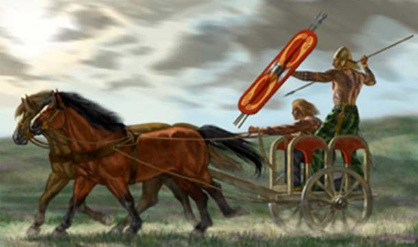
The design of the Celtic chariot—often called a carbad in early Irish literature—relied on lightweight, flexible materials that could absorb the shock of navigating rugged, uneven terrain.

  • Materials: The framework was typically constructed from flexible hardwoods like ash and oak. Wickerwork was often used for the sides of the chariot box (cret) to keep the weight to a minimum while maintaining structural integrity.

  • Joints and Suspension: Instead of using rigid metal nails or adhesives, builders bound the joints using wet rawhide. As the rawhide dried and shrank, it tightened, creating a highly durable, shock-absorbing frame.

  • Spoked Wheels: The wheels were a significant technological achievement, featuring up to 12 to 14 wooden spokes set into a bent-wood rim. Iron tires were heat-shrunk around the wooden wheel, clamping the structure tightly and protecting the wood from abrasion and rocky ground.

2. Battlefield Tactics and Social Function

Rather than functioning as heavy shock-cavalry or front-line battering rams, the Celtic chariot served primarily as a mobile, high-speed transport platform for elite warriors.

  • The Two-Man Crew: A typical chariot carried a driver (charioteer) and a warrior. The driver was responsible for maneuvering the horses, while the warrior engaged in combat.

  • Hit-and-Run Tactics: As documented by Julius Caesar during his campaigns in Britain, Celtic warriors would ride up and down the battle lines throwing javelins to disrupt the enemy's ranks. When the warrior wished to engage in close combat, they would dismount, fight with a long sword, and return to the chariot for a rapid escape.

  • A Symbol of Prestige: Maintaining a chariot, the harness gear, and a dedicated team of horses was extraordinarily expensive. Chariots served as a visual testament to the wealth and status of the Celtic aristocracy.

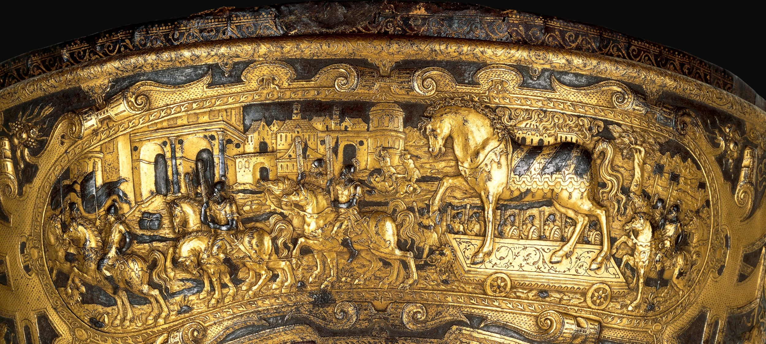
3. Artistic Adornment and Fittings

The fittings of the chariot and its horses were highly decorated, featuring the intricate, curvilinear motifs characteristic of La Tène art.

  • Harness Gear and Linchpins: The wheels were secured by linchpins made of iron or bronze, sometimes forged with stylized animal shapes or inlaid with coral and red enamel.

  • Acoustic Impact: The rumble of iron tires and the clatter of metal decorations added psychological weight to a chariot's approach, announcing the status of the warrior long before they reached the front line.

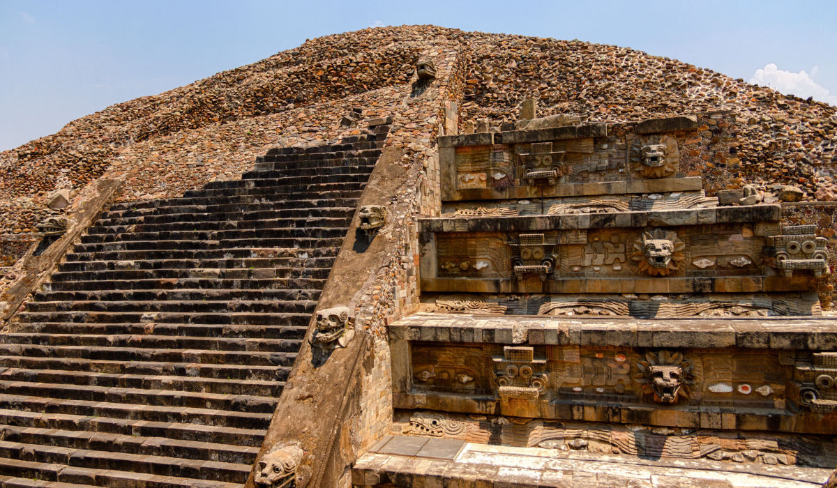
4. Archaeological Discoveries

While organic materials like wood rot quickly in acidic soil, vital components such as iron tires, linchpins, and bronze harness rings are regularly preserved in both continental Europe and the British Isles.

  • The Newbridge Chariot: Unearthed near Edinburgh, Scotland, this 5th-century BCE find is the oldest known chariot burial discovered in Britain. The burial rite and construction details mirrored similar elite graves in France and Belgium.

The Temple of the Feathered Serpent: Ritual Sacrifice in Teotihuacan

May 10, 2026

The Temple of the Feathered Serpent: Ritual Sacrifice in Teotihuacan

Located in the ancient Mesoamerican city of Teotihuacan, the Temple of the Feathered Serpent (also known as the Quetzalcoatl Pyramid) is one of the most striking and enigmatic architectural monuments in the Americas. Built around 200 CE, this six-tiered step pyramid is renowned not only for its intricate architectural design but also for the massive evidence of ritual sacrifice discovered within its structure, which sheds light on the state-sponsored ideology and cosmic beliefs of the Teotihuacan civilization.

1. Architecture and Iconography

The temple’s exterior is an exceptional example of monumental sculpture integrated into architecture. The façade features a repeating pattern of stone carvings that project outward, representing two distinct deities.

  • The Feathered Serpent: Alternating with the second deity, these sculptures depict a serpent adorned with elaborate, sweeping feathers, representing a primordial creator and rain-bringing deity.

  • The Goggle-Eyed Deity: Paired with the serpent is a fierce, fanged deity with large, circular eyes. Historically identified as Tlaloc (the rain god), many contemporary archaeologists now associate it with the Teotihuacan War Serpent, which symbolizes warfare, solar power, and state authority.

2. The Evidence of Mass Sacrifice

During extensive excavations in the 1980s, archaeologists discovered that the construction of the pyramid was accompanied by a series of massive dedicatory sacrifices. The victims were buried in groups at the four cardinal corners and the center of the structure.

  • Positioning of the Victims: Over 200 skeletons were found with their hands bound behind their backs, indicating they were captives or sacrificial offerings. They were arranged symmetrically, often facing outward.

  • Status and Attire: The victims wore necklaces made of real human maxillae (upper jawbones) and animal teeth, as well as greenstone and shell ornaments, suggesting they were individuals of high status or captured enemy warriors.

  • Burial Goods: The graves contained a vast array of high-value offerings, including obsidian blades, stingray spines, and pottery, which were intended to accompany the victims into the afterlife.

3. Meaning and Sociopolitical Function

The sacrifices at the Temple of the Feathered Serpent were not random; they were highly orchestrated, state-sanctioned events designed to legitimize the ruling class and maintain cosmic balance.

  • Dedicatory Rituals: The mass burials are thought to correspond to the inauguration or expansion of the pyramid. Each phase of construction was marked by the spilling of blood to consecrate the site.

  • Military Propaganda: The presence of individuals from foreign regions suggests that the sacrifices were a display of Teotihuacan's military dominance, using ritual violence to intimidate rivals and unite the multi-ethnic population of the city under one belief system.

4. The Teotihuacan Worldview

The architecture of the pyramid was designed to replicate a sacred mountain—a physical and spiritual axis linking the underworld, the earth, and the heavens. The sacrifice of human lives was seen as a necessary transaction between the gods and humanity to ensure the continuation of agricultural fertility, rainfall, and the cosmic order.

Roman Mosaic Floors: Decoding the Mythology of the Zeugma Site

May 10, 2026

Roman Mosaic Floors: Decoding the Mythology of the Zeugma Site

Located on the banks of the Euphrates River in modern-day Gaziantep, Turkey, the ancient city of Zeugma was a crucial crossing point and a vibrant multicultural hub of the Roman Empire. Named after the Greek word for "bridge" or "crossing," Zeugma became a wealthy residential center where Roman officers and merchants built lavish villas.

The floors of these villas were adorned with exquisite, narrative-rich mosaics that served not only as status symbols but also as a visual library of Greco-Roman mythology, beliefs, and local geography.

1. The Mythological Narratives

The mosaics of Zeugma depict complex and lively mythological stories, with artists using perspective and vibrant color to bring ancient tales to life.

  • Oceanus and Tethys: Found in the shallow pool of the House of Oceanus, this stunning mosaic depicts Oceanus (the god of all river gods) and his wife, Tethys (the titan goddess of freshwater springs). They are surrounded by sea creatures, dolphins, and Erotes. The mythical dragon Cetus is placed between the couple, symbolizing the neighboring Euphrates River.

  • Achilles Revealed on Skyros: Located in the Poseidon Villa, this intricate floor mosaic captures the moment Odysseus tricks Achilles into revealing his true identity. To prevent him from going to the Trojan War, his mother disguised Achilles as a woman, but Odysseus placed weapons among the women's items, causing the hero to instinctively reach for a sword.

  • Akratos and Euphrosyne: Discovered near the famous "Gypsy Girl" mosaic, this composition features Akratos (the personification of the sacred cup or spirit) offering wine from a divine source to Euphrosyne, the water fairy and goddess of merriment, emphasizing abundance and hospitality.

2. The Iconic "Gypsy Girl"

The most recognizable piece of art from the site, the "Gypsy Girl" (Çingene Kızı), is highly debated among archaeologists and historians:

  • The Identity: Some scholars suggest the figure is a Maenad—a female follower of Dionysus—due to the vine leaves painted nearby. Others argue it is the Titaness Gaia, the goddess of the Earth, or even a portrait of Alexander the Great.

  • Artistic Technique: The figure's expressive eyes are drawn using a technique that gives them an intense, three-dimensional gaze. Her eyes seem to follow the viewer across the room, much like the Mona Lisa.

3. Materials, Techniques, and Design

The Zeugma mosaics were not just decorative; they were designed for the specific spaces they occupied, often interacting with the architecture and the water features of the villas.

  • Tesserae: The pieces are made of carefully cut natural stone and glass in various colors, giving the scenes high definition and vibrant hues.

  • Architectural Integration: Many mosaics were designed to be viewed from specific angles within a peristyle courtyard or as the decorative floor of an impluvium (water pool). When the shallow pools were filled with a few inches of water, the wave motifs along the borders created a dynamic optical illusion.

4. Rescue and Preservation

In the late 1990s, the construction of the Birecik Dam threatened to submerge the archaeological site under the Euphrates River. Rushed rescue excavations unearthed a vast treasure trove before the waters rose.

  • The Museum: Today, most of the mosaics are displayed at the Gaziantep Zeugma Mosaic Museum, the largest mosaic museum in the world.

The Monumental Rebirth of the Kasta Tumulus at Amphipolis

May 10, 2026

After fourteen years of excavations, conservation work, and large-scale restoration efforts, the monumental enclosure of the Kasta Tumulus at Amphipolis has now been revealed almost in its entirety, offering for the first time a complete sense of the monument’s true scale and geometry. The renewed image of the funerary complex is striking, as visitors can now walk around the circular enclosure and fully appreciate its immense dimensions, architectural precision, and luxurious construction, elements that confirm the monumental character of one of the most important funerary structures of ancient Macedonia. With a diameter exceeding 140 meters, the tumulus is now considered the largest Hellenistic burial mound ever uncovered, while restoration works continue with the contribution of archaeologists, architects, engineers, and major research institutions.

During her on-site inspection, Minister of Culture Lina Mendoni described the monument as “magnificent,” emphasizing that the latest scientific evidence confirms its dating to the last quarter of the 4th century BC, directly linking it to the era of Alexander the Great and the immense wealth flowing into the Macedonian kingdom during that period. At the same time, plans are advancing for the creation of a new museum space and modern visitor infrastructure, with the goal of opening the Kasta Tumulus fully to the public by early 2028. The overall project, with a budget exceeding 15 million euros, aims to establish Amphipolis as one of the leading archaeological destinations in Greece and the wider Mediterranean.

The Discovery of Troy: How Schliemann’s Obsession Changed Archaeology

May 6, 2026

The Discovery of Troy: How Schliemann’s Obsession Changed Archaeology

For centuries, the story of the Trojan War and the city of Troy were widely considered by modern historians to be nothing more than myth and poetic invention by Homer in the Iliad. That all changed in the 1870s when a wealthy German businessman and amateur archaeologist named Heinrich Schliemann set out to prove that the legends were rooted in historical fact. His relentless, albeit controversial, obsession not only located the ancient site of Troy but laid the groundwork for modern field archaeology.

1. The Boyhood Obsession and the Search

From a young age, Schliemann was captivated by the epic tales of the Trojan War. While many viewed the Iliad as pure fantasy, he believed that the cities described in the poems were real places waiting to be found.

  • The Shift in Location: Initially, scholars and local experts (including British archaeologist Frank Calvert) debated the site of ancient Troy. While many favored the hilltop of Pınarbaşı, Calvert identified the mound of Hisarlık in northwestern Turkey as the true location and convinced Schliemann to fund the excavations.

  • The Excavations Begin: In 1870, Schliemann began exploratory soundings at Hisarlık, using his immense personal fortune to hire a large labor force of 80 to 160 workers.

2. Excavation Methods and "Schliemann's Trench"

Schliemann's approach to the site was far from scientific by modern standards and resulted in significant destruction to the archaeological record.

  • The Great Trench: To reach the lowest levels of the tell (the artificial mound formed by centuries of habitation), Schliemann cut a massive 17-meter (56-foot) gash, known today as Schliemann's Trench, straight through the center of the site.

  • Destroyed Evidence: In his rush to reach the bottom layer, which he assumed must be the Homeric Troy, his workers cleared away and discarded structures and layers that belonged to later, historically important periods.

3. Priam's Treasure and Controversy

In May 1873, Schliemann’s team uncovered a spectacular cache of gold, bronze, and silver artifacts near the defensive walls, which he named "Priam's Treasure."

  • The Artifacts: The hoard included diadems, golden pendants, and thousands of pieces of intricately worked gold, which Schliemann claimed belonged to the mythical King Priam of Troy.

  • Smuggling and Media Sensationalism: Eager to protect his finds from the Ottoman authorities, Schliemann smuggled the treasure out of Turkey into Greece. The resulting international scandal brought immense media attention to his discoveries.

  • Dating Discrepancies: Modern archaeologists later determined that the treasure dates to roughly 2500 BCE, over a thousand years before the time of the Late Bronze Age Trojan War.

4. The Legacy: From Treasure Hunting to Stratigraphy

Although Schliemann's methods were often destructive, his work revolutionized archaeology by shifting the focus from mere classical antiquities to the exploration of early prehistoric civilizations.

  • Refining the Science: Following Schliemann's initial excavations, experts like Wilhelm Dörpfeld and later Carl Blegen introduced rigorous stratigraphic recording methods.

  • The Real Homeric Troy: Dörpfeld correctly identified Troy VI and Troy VIIa as the most likely candidates for the Late Bronze Age city of the Trojan War, which aligned with the Mycenaean period.

Ancient Sumerian Cylinder Seals: The Tiny Masterpieces of Mesopotamia

May 6, 2026

Ancient Sumerian Cylinder Seals: The Tiny Masterpieces of Mesopotamia

Invented in the late 4th millennium BCE in ancient Mesopotamia (primarily at sites like Uruk and Susa), the cylinder seal is one of the most distinctive and important artifacts of the Sumerian civilization. Ranging from one to two inches in height, these tiny, finely carved stone cylinders were used to roll an impression onto a two-dimensional surface, generally wet clay.

They are widely regarded by art historians as the most characteristic object of the era, functioning as miniature works of art, signatures, and administrative tools.

1. Materials and Craftsmanship

The creation of a cylinder seal was a highly specialized craft. The stones used had to be carefully shaped, drilled through the center to be worn on a necklace or cord, and intricately carved.

  • Materials: Because Mesopotamia lacked an abundance of good stone, raw materials were imported from distant regions. Seals were carved from a variety of stones, including lapis lazuli (imported from modern-day Afghanistan and highly prized for its vibrant blue color), hematite, serpentine, and carnelian.

  • Technique: Seal carvers worked in intaglio, meaning the design was cut into the hard stone in reverse and in the negative. When the cylinder was rolled across wet clay, it produced a raised, positive relief image.

2. Purpose and Function

Sumerian cylinder seals served several vital roles in both daily economic life and the spiritual world:

  • Administrative Signatures: As bureaucracy and trade expanded, the seals acted as an individual's personal signature to authenticate clay tablets, contracts, and receipts.

  • Security and Property Protection: They were impressed upon lumps of clay (sealings) used to secure the knots of storage room doors or the lids of jars, ensuring that goods were not tampered with.

  • Jewelry and Amulets: Because of their beauty and the prestige of the materials, they were worn as high-status jewelry or protective amulets to ward off evil spirits. Many have been discovered as grave goods in elite burials.

3. Artistic Themes and Iconography

The tiny surfaces of the seals feature an astonishing level of detail. The designs provide historians with an unparalleled look into the mythology, daily life, and religious concepts of ancient Sumer.

  • Mythological and Religious Scenes: Common subjects include deities, priests, or mythological heroes, such as the legendary King Gilgamesh.

  • Banquet Scenes: Depictions of elite individuals seated together, drinking, and being served by attendants.

  • Contest Scenes: Stylized depictions of heroes and animals—such as lions and bulls—battling mythical beasts.

The Nazca Puquios: Ancient Hydraulic Systems That Still Work Today

May 6, 2026

The Nazca Puquios: Ancient Hydraulic Systems That Still Work Today

Built between 300 and 600 CE in the hyper-arid coastal desert of southern Peru, the puquios are a masterful network of underground aqueducts, surface channels, and reservoirs developed by the ancient Nazca culture. Located just a few miles from the famous and mysterious Nazca Lines, the puquios represent a triumph of practical engineering that allowed the civilization to transform an arid landscape into a green, habitable valley.

Remarkably, more than 30 of these ancient aqueducts are still functioning and providing water today.

1. The Design and Architecture of the System

The puquios are essentially filtration galleries designed to tap into underground aquifers and guide the water to where it is needed without significant loss to evaporation.

  • Underground Galleries: The core of the system consists of underground channels dug into the gravelly alluvial fans of the Andean foothills. They typically measure 50 to 80 cm wide and up to 1.5 meters high, lined with river cobbles and built without mortar to allow water to filter in slowly and naturally.

  • Open Trenches: As the tunnels approach settlements and cultivated fields, they transition into open, stone-lined trenches (socavón) where the water re-emerges at the surface.

  • Reservoirs (Cochas): The open canals empty into small, stone-lined reservoirs or pools, which serve as distribution points for drinking water and crop irrigation.

2. The Ojos (The Spiral Eyes)

One of the most striking features of the puquios is the presence of large, funnel-shaped, spiraling wells known locally as ojos (eyes) that dot the desert floor.

  • Maintenance Access: The wide, corkscrew design allowed workers to climb down into the deep subterranean tunnels for regular desilting and maintenance.

  • Ventilation and Pumping: Studies, particularly those led by researchers using satellite imagery, revealed an ingenious secondary function. The funnel shape of the ojos and their alignment with the prevailing desert winds catch and force air into the underground tunnels. This increases air pressure inside the channels, acting as a natural, wind-driven pump to push water through the system.

3. Construction and Materials

To withstand millennia of seismic activity and climate shifts, Nazca engineers chose highly durable, locally sourced materials:

  • River Boulders: The tunnels and trench walls are lined with smooth, round river boulders without the use of mortar. This porous structure prevents the soil from collapsing while still allowing subsoil water to percolate into the channel.

  • Traversing Slopes: The system relies on a gentle gradient (averaging 1.4%) to maintain a constant, controlled water flow velocity, preventing soil erosion or flooding.

4. Climate Resilience and Modern Utility

The puquios offer a remarkable lesson in sustainable water management:

  • Insensitivity to Precipitation: Because the system taps into deep groundwater aquifers rather than relying on surface rainfall, it provides a consistent water supply even through prolonged droughts.

  • Community Management: The ongoing maintenance of the puquios relies on community cooperation, ensuring that access to the life-giving water is managed democratically and sustainably across generations.

Roman Military Camps: Life on the Limes of the Danube River

May 6, 2026

Roman Military Camps: Life on the Limes of the Danube River

The Danube Limes (Donaulimes) formed a crucial defensive and cultural frontier of the Roman Empire, spanning over 2,000 kilometers from Bavaria to the Black Sea. Far from being just a defensive barrier, the Danube border was a bustling, interconnected economic zone where soldiers, merchants, and local populations interacted daily.

1. The Danube Frontier Network

The term limes originally referred to a border path before evolving to describe a comprehensive network of pathways, fortifications, and river barriers securing the empire. On the Danube, this was known as the "Wet Limes."

  • The Defense System: The frontier was composed of legionary camps (castra), smaller auxiliary forts (castella), and watchtowers placed 10 to 30 kilometers apart to maintain visual communication and rapid signaling.

  • The Infrastructure: A major military road, the Via Istrum, ran alongside the river, linking the military outposts and allowing for rapid deployment and resupply.

  • Major Bases: Key outposts included Carnuntum and Vindobona (modern-day Vienna) in Austria, as well as Lauriacum (Enns) and Castra Regina (Regensburg).

2. Architecture and Layout of the Camps

Roman military camps were engineered with strict geometric precision, establishing order in the wilderness:

  • Standardized Layout: Modeled after a playing-card shape with rounded corners, the camp was divided by two main intersecting roads: the via principalis and the via praetoria.

  • Key Facilities: The interior included the commander’s residence (praetorium), the administrative center (principia), the granaries (horrea), and the military hospital (valetudinarium).

  • Construction Evolution: The camps began as wood-and-earth ramparts. Under Emperor Trajan and his successors, they were reinforced with solid stone walls to withstand sieges and harsh winters.

3. Life and Duties on the Limes

Life in these frontier fortresses was highly organized and demanding, shaped by rigorous military routine and the realities of the borderlands:

  • Daily Routines: Soldiers alternated between building infrastructure, gathering supplies, rigorous training, and standing watch at the border outposts.

  • The Living Quarters: A standard infantry century consisted of 80 men living in a barrack block, divided into ten units of eight men (contubernium). Each unit shared a pair of rooms—one for sleeping and cooking, and another for equipment storage.

  • Auxiliary Troops: Alongside Roman legionaries, auxilia (non-citizen troops) were stationed on the border. After 25 years of service, these soldiers were granted Roman citizenship.

4. Trade, Coexistence, and the Civilian Population

The frontier was not an impenetrable wall, but rather a zone of heavy interaction with the territories across the river:

  • Canabae and Vici: Large civilian settlements—known as canabae near the legionary camps and vici near smaller forts—grew up around the military installations. Traders, craftsmen, families, and retired veterans created bustling, cosmopolitan communities.

  • Cultural Exchange: Soldiers brought Mediterranean culture, wine-growing techniques, and thermal baths to Central Europe. The markets hosted peaceful trade with neighboring Germanic tribes, exchanging Roman manufactured goods for raw resources such as amber and furs.

The Maya Blue Pigment: The Chemistry of an Ancient Artistic Miracle

May 6, 2026

The Maya Blue Pigment: The Chemistry of an Ancient Artistic Miracle

For centuries, Mesoamerican ruins and artworks have retained their vivid turquoise hue, baffling conservators and historians. Known as Maya Blue, this unique colorant is an artificial nano-structured hybrid pigment created well before the advent of modern materials science.

Unlike conventional ancient pigments that rely purely on inorganic minerals (like azurite) or organic plant dyes (like plain indigo), Maya Blue combines both, creating a highly stable and luminous color.

1. The Ingredients: Clay and Plant Dye

The pigment is composed of two primary natural components found in the Mesoamerican region:

  • Palygorskite: A fibrous, needle-like clay mineral (often called sak lu'um or "white earth") characterized by its unique hollow microchannels and lattice structure.

  • Indigo: An organic dye extracted from the leaves of the Indigofera suffruticosa plant (locally known in Mayan as ch'oj).

2. The Chemical Structure: How the Hybrid Works

The secret to the pigment's vibrancy and extreme durability lies in the interaction between the organic dye and the inorganic clay matrix when heated.

  • Intercalation: Upon heating, the indigo molecules enter the internal channels and microscopic pores of the palygorskite clay.

  • Hydrogen Bonding: The carbonyl oxygen or nitrogen-hydrogen groups of the indigo molecules form strong hydrogen bonds with the clay's structural water and surface metal ions ($Al^{3+}$ and $Mg^{2+}$).

  • Oxidation: A portion of the indigo oxidizes into dehydroindigo during the heating process. This mixture of indigo and dehydroindigo produces the distinctive bluish-green spectrum and locks the colorant securely within the mineral framework.

3. The Manufacturing Process

Archaeological and chemical studies have uncovered multiple ways the ancient Maya manufactured this pigment:

  • The Copal Resin Method: The mixture of palygorskite, indigo, and ceremonial copal incense was heated to approximately 100 to 150 °C. The resin acted as a heat-activated catalyst and binder, helping anchor the pigment molecules.

  • The Wet-Milling and Firing Method: Recent excavations at Chichén Itzá show that artisans ground the wet clay with indigo and heated the mixture from below inside ceramic bowls, entirely bypassing the need for copal.

4. The Miracle of Stability

What makes Maya Blue so extraordinary is its near-total resistance to environmental and chemical agents that would normally destroy ancient organic dyes:

  • Acid and Solvent Resistance: The pigment is impervious to boiling nitric acid, alkalis, and exposure to strong chemicals.

  • Environmental Endurance: It survives the harsh tropical humidity, rain, and sunlight of the Mesoamerican rainforests without fading.

  • Biocorrosion Resistance: It resists bacteria and fungi that typically break down organic materials.

Viking Trade Routes: From the Fjords of Norway to the Markets of Baghdad

May 6, 2026

Viking Trade Routes: From the Fjords of Norway to the Markets of Baghdad

While the popular image of the Viking Age often centers on maritime raids across Western Europe, the Scandinavian expansion to the East was defined by extensive networks of trade, diplomacy, and exploration. The Volga trade route connected the fjords of Norway and the trading hubs of the Baltic directly to the wealthy markets of the Abbasid Caliphate in Baghdad, creating an economic pipeline that brought thousands of Islamic silver coins (dirhams) into the Scandinavian economy.

1. The Eastern Network: The Volga Trade Route

The journey to the East was pioneered by the Rus'—predominantly Swedish and Norwegian Norsemen who ventured into the river systems of Eastern Europe.

  • The Gateway: Traders started from Scandinavian ports such as Birka (Sweden), Hedeby (Denmark), and Kaupang (Norway), crossing the Baltic Sea to reach Staraya Ladoga (Aldeigjuborg) in present-day Russia.

  • River Navigation: From Ladoga, the Rus navigated the Volkhov River, crossing Lake Ilmen, and following the Lovat River.

  • Portages: Because the ships (the knarr or karvi) were shallow-drafted, they could be hauled overland—a process called portage—across the short distances separating river basins to reach the headwaters of the Volga River.

2. The Journey Down the Volga

The passage down the Volga brought travelers into contact with distinct cultures and major trading powers of the 9th and 10th centuries:

  • Volga Bulgaria: A booming semi-nomadic confederation situated at the confluence of the Kama and Volga rivers. Here, the Vikings encountered the westernmost terminal of the overland Silk Road caravans coming from Central Asia and China.

  • The Khazar Khaganate: The Rus' traders passed through the Khazar capital of Atil at the mouth of the Volga. The Khazars controlled the trade moving from the Caspian Sea to the Black Sea and the Caucasus.

  • The Caspian Sea and Baghdad: From Atil, the Vikings sailed across the Caspian Sea (Sea of Jurjan) to the southern shores. From there, goods were carried inland on camelback to Baghdad, the capital of the Abbasid Caliphate—which the Norse called Særkland (the "Land of Silk").

3. The Economy of Exchange: Silver and Slaves

The trade along this route was dictated by supply and demand. Northern Europe had an abundance of raw materials highly valued in the East, while the Islamic world offered manufactured goods and bullion.

  • Northern Exports: The Rus traded animal furs (marten, beaver, and fox), amber, honey, wax, falcons, and enslaved people captured or purchased in neighboring European territories.

  • Southern Imports: In return, they acquired enormous quantities of silver coins (Samanid dirhams), high-quality crucible steel, glass beads, and silk fabrics.

  • The Arab Accounts: The Arab geographer Ibn Khordadbeh wrote in 885–886 about Rus merchants taking their goods via the Caspian Sea and camels to Baghdad, sometimes presenting themselves as Christians to gain access to the city.

4. The Decline of the Route

The trade route peaked during the 9th and 10th centuries, when silver was the lifeblood of the Viking economy. By the late 10th century, the flow of dirhams began to wane due to the exhaustion of mines and political changes in the Islamic world. The focus of the Eastern Vikings then increasingly turned toward the Dnieper trade route (the route from the Varangians to the Greeks) connecting them to Constantinople.

The Paleo-Diet: What Coprolites Reveal About Prehistoric Human Nutrition

May 6, 2026

The Paleo-Diet: What Coprolites Reveal About Prehistoric Human Nutrition

When we think about prehistoric human diets, it is easy to imagine a menu dominated entirely by big-game hunting. However, the most direct, unfiltered evidence of what early humans actually ate comes from an unexpected source: coprolites (fossilized or desiccated feces).

By analyzing the chemical, microscopic, and genetic signatures preserved within these ancient remains, researchers are rewriting the narrative of the Paleolithic diet and revealing a complex, highly varied approach to nutrition.

1. What Are Coprolites?

Coprolites are the preserved remains of digestive waste. Under specific conditions—such as the hyper-arid environments of caves or rockshelters—feces can undergo rapid desiccation or mineralization, preserving fragile organic material for thousands of years.

  • Physical Remains: They can contain undigested seeds, fragments of bone, fish scales, and plant fibers.

  • Biomarkers and DNA: Modern biomolecular techniques allow scientists to extract ancient DNA (aDNA) and proteins from the waste, identifying the exact species consumed and the bacteria that lived in the human gut.

2. Nutritional and Dietary Revelations

Coprolite analysis offers a microscopic and chemical snapshot of a single meal, providing highly specific data about nutrient intake.

  • High-Fiber Diets: Contrary to modern high-protein or low-carb interpretations of the Paleo diet, coprolites from the Upper Paleolithic show massive amounts of dietary fiber. Early humans regularly consumed a wide range of roots, tubers, wild grasses, and fruits.

  • Micro-nutrients and Phytoliths: The discovery of phytoliths (silica structures found in plants) reveals that early humans processed and consumed an incredible diversity of vegetation, even using wild grains and starchy roots.

  • Meat Consumption: While plants were abundant, coprolites also contain traces of meat, hair, and bone fragments, confirming an omnivorous diet that capitalized heavily on available resources.

3. Challenging the Modern "Paleo" Fad

One of the biggest nutritional corrections driven by coprolite science is the dismantling of the idea that Paleolithic humans avoided all carbohydrates or lived on a uniform, strict diet.

  • Seasonal Variation: Analysis shows that the diet changed drastically with the seasons. Spring coprolites might contain leafy greens and early shoots, while winter samples indicate a heavier reliance on stored or dried meat and cached nuts.

  • Carbohydrate Consumption: Studies of both Neanderthal and early Homo sapiens coprolites show the presence of starches and complex carbohydrates, proving that early humans consumed a significant amount of plant matter when it was available.

4. Unlocking the Ancient Microbiome

Beyond the food consumed, the bacteria and microbes preserved in these samples give us a direct look into the prehistoric human microbiome.

  • Gut Diversity: Unlike modern industrialized populations with less diverse gut flora, prehistoric coprolites show a rich, varied microbial ecosystem suited for breaking down wild plants and raw fibers.

  • Pathogens: Traces of parasites and worm eggs have also been found, indicating that early humans dealt with the nutritional drain of chronic parasitic infections alongside their regular foraging.

Ancient Greek Medicine: The Healing Sanctuaries of Asclepius

May 6, 2026

Ancient Greek Medicine: The Healing Sanctuaries of Asclepius

Dedicated to Asclepius, the Greek god of medicine and healing, the Asclepieia (singular: Asclepieion) were far more than simple temples. They functioned as comprehensive healing centers that combined spiritual faith with natural remedies, physical therapies, and psychological well-being. These sanctuaries laid the foundations for early holistic medicine in the ancient Mediterranean.

1. The Layout and Architecture of the Sanctuaries

The sanctuaries were typically built in serene, natural settings known for their fresh air, mineral springs, and peaceful surroundings, as the environment was considered a crucial part of the healing process.

  • The Temple (Naos): The religious center of the sanctuary, housing the cult statue of Asclepius, often made of gold and ivory.

  • The Abaton (or Koimeterion): A long, covered stoa or dormitory where patients slept to await a visitation from the god.

  • The Tholos: A mysterious circular building, often featuring intricate subterranean labyrinths or concentric circles, whose exact purpose remains debated by archaeologists (possibly used as a symbolic home for the sacred snakes of Asclepius).

  • Ancillary Facilities: Most major sanctuaries included a gymnasium, a stadium for athletic recovery, and a large theater for performances, as mental stimulation and art were considered integral to recovery.

2. The Healing Process: The Ritual of Incubation

The central therapeutic practice at the Asclepieion was the ritual of incubation (enkoimesis), a form of dream therapy.

  1. Purification: Patients first underwent ritual cleansing by bathing in cold or mineral springs and offering sacrifices to the gods.

  2. Consultation: Priests reviewed the patient's symptoms and prepared them for their night in the abaton.

  3. The Dream: While sleeping in the dormitory, patients would pray for a visitation from Asclepius or his sacred, non-venomous snakes. In the dream, the god might touch the affected area or provide a prescription (such as a specific diet, herbal remedy, or physical exercise).

  4. Interpretation: The following morning, priests helped interpret the dreams and administer the prescribed cures.

3. Medical Practices and Holistic Care

While the healing process was heavily rooted in religious belief, the priests and attendants also applied practical medical treatments:

  • Herbal Medicine and Surgery: Priests used poultices, natural ointments, and basic surgical procedures alongside divine remedies.

  • Diet and Exercise: Regimens involving specific foods, hydrotherapy, and physical training were highly recommended to restore the balance of the body's humors.

  • Psychological Healing: The beautiful natural landscapes, combined with dramatic performances and social interaction, played a large role in lowering stress and promoting healing.

4. The Most Famous Asclepieia

Several sanctuaries grew into prominent medical and cultural hubs, the most notable being:

  • Epidaurus: The most important and the architectural model for other healing centers, famous for its grand theater and tholos.

  • Kos: The home of the medical school associated with Hippocrates, where medicine began to diverge slightly from divine intervention toward clinical observation.

  • Pergamon: Located in modern-day Turkey, it featured a famous library, a medical complex, and a natural spring where patients were treated with mud baths and herbs.

The Kingdom of Kush: The Royal Pyramids of Meroë and Their Secrets

May 6, 2026

The Kingdom of Kush: The Royal Pyramids of Meroë and Their Secrets

The desert plains of Sudan hold an archaeological wonder that frequently surprises those who associate pyramids solely with Egypt. Meroë, the final capital of the ancient Kingdom of Kush, is home to more than 200 pyramids—making it the largest concentration of pyramids in the world. Built over a thousand years after the last Egyptian pyramids, these monuments represent an incredible feat of engineering and a testament to an African civilization that engaged in trade spanning from the Mediterranean to India and China.

1. The Distinctive Architecture of Meroë

The pyramids of Meroë, built between 270 BCE and 320 CE, differ significantly in style and scale from their Egyptian predecessors.

  • Steep Angles: The Kushite pyramids are much narrower at the base relative to their height, giving them a distinct, steep slope. They range from 6 to 30 meters (20 to nearly 100 feet) in height.

  • Integrated Chapels: Unlike Egyptian tombs, attached to the eastern face of a Meroitic pyramid is a small, dedicated offering chapel or temple. These chapels often feature prominent pylon (tapering gateway) structures and carved stelae.

  • Solid Construction: The pyramid itself acts as a solid monument rather than a hollow vault; the outer layers of dressed sandstone encase an internal core of packed rubble and dirt.

2. The Hidden Tombs Beneath

The most fascinating secrets of Meroë lie hidden beneath the sand rather than inside the stone superstructure itself.

  • Underground Tombs: A narrow, buried staircase descends from the surface in front of the chapel, leading into a sequence of two or three underground burial chambers cut directly into the bedrock.

  • Vibrant Frescoes: The underground walls are adorned with brightly colored painted murals and gypsum reliefs depicting both Kushite and Egyptian deities, such as Isis and Osiris, reflecting their blended religious traditions.

  • The Ba Statues: The offering chapels once held distinctive, carved statues of the ba—the aspect of the human soul depicted as a human-headed bird—designed to allow the deceased to journey between the physical and spiritual worlds.

3. Advanced Construction Techniques

Kushite engineers successfully sustained a monumental building boom over centuries by combining local iron-age technology with borrowed methods.

  • The Shaduf Lever: Excavations and archaeological finds have revealed the use of the shaduf—a counterweighted lever or wooden crane—anchored at the center of the structure, used to lift sandstone blocks and red bricks into place.

  • Finish and Form: Originally, the structures were faced with white or red plaster and featured striking decorative capstones (like solar discs) made of sandstone or bronze, catching the reflection of the desert sun.

4. The Black Pharaohs and Powerful Queens

Meroë was the seat of a wealthy, independent culture that had its own writing system (Meroitic script) and a society with high female political participation.

  • The 25th Dynasty: Kushite kings conquered Egypt in the 8th century BCE and ruled as the "Black Pharaohs," reviving the tradition of pyramid building during their reign.

  • Queen Mothers (Kandakes): Meroitic society elevated royal women to positions of sovereign power. Queens such as Amanirenas and Amanishakheto are depicted on their pyramid walls as strong leaders, sometimes wearing armor and participating in the protection of the state.

Roman Pompeii: New Discoveries in the Insula of the Chaste Lovers

May 6, 2026

Roman Pompeii: New Discoveries in the Insula of the Chaste Lovers

The Insula of the Chaste Lovers (Insula dei Casti Amanti, located in Regio IX) is one of the most significant and dynamic excavation projects in the Pompeii Archaeological Park. Recent excavations, structural stabilization, and the addition of a suspended walkway network have brought extraordinary new details to light, offering an intimate glimpse into the final hours of the city's inhabitants.

1. The Insula Complex

The insula is a complete city block spanning over 1,500 square meters. Its name originates from a detailed fresco in the dining room depicting a couple sharing a tender, chaste kiss during a banquet. The complex consists of several interconnected structures used for both commercial and residential purposes:

  • The House of the Chaste Lovers: A luxurious domus featuring well-preserved triclinium walls and beautiful decorations.

  • The House of the Painters at Work: A property named for the painting tools, pigment cups, and unfinished frescoes that were frozen in time as workers rushed to evacuate.

  • The House of the Colonnaded Cenacle: Named for the peristyle inner courtyard surrounded by columns.

2. Recent Archaeological Discoveries

Ongoing investigations, maintenance, and safety work along the block's perimeter have revealed remarkable new archaeological layers:

  • Syn-eruptive Earthquakes: In a utility room, archaeologists discovered the skeletons of two men over the age of 55 who died not from ash inhalation or pyroclastic flow, but from the severe earthquakes that accompanied the eruption. The walls of the room detached and collapsed, crushing the individuals as they sought shelter.

  • Intact Artifacts: Alongside the victims, researchers found stacked vessels, bowls, jugs, and a bundle wrapped in fabric containing coins and glass-paste necklace beads.

  • The "House of Phaedra": Excavators uncovered a small residence deviating from the traditional atrium plan, decorated with vibrant Fourth-Style mythological frescoes depicting the myth of Hippolytus and Phaedra, Venus and Adonis, and a scene of a satyr and nymph.

  • The Black Salon: A formal banqueting room with elegant black walls decorated with mythological subjects inspired by the Trojan War, featuring the inscription hic et ubique and still-life paintings of fish and game.

3. Insights into Daily Life and Commerce

The findings demonstrate a bustling commercial and domestic space undergoing renovation when Mount Vesuvius erupted in 79 CE.

  • Interrupted Craftsmanship: Cups still full of pigment and preparatory wall drawings provide unique evidence of the construction work taking place in the last days of the city.

  • A Working Bakery: The complex includes a large, functioning bakery with stone millstones, stables that housed the remains of draft animals, and a large oven.

The Sea Peoples: Identifying the Mysterious Confederation That Ended the Bronze Age

May 6, 2026

The Sea Peoples: Identifying the Mysterious Confederation That Ended the Bronze Age

The Late Bronze Age (c. 1550–1200 BCE) was a period of high civilization, marked by prosperous empires such as the Hittites, Mycenaeans, and the New Kingdom of Egypt. Within a span of just a few decades around 1200 BCE, many of these centers were destroyed or abruptly abandoned, marking the beginning of the collapse. Egyptian texts from the era identified a shadowy, confederate group of raiders known as the Sea Peoples as a major force in these dramatic events.

1. The Historical Inscriptions

Our primary written knowledge of the Sea Peoples comes from monumental Egyptian records and inscriptions.

  • The Merneptah Stele (c. 1207 BCE): During the reign of Pharaoh Merneptah, Egypt fought off a coalition of Libyans and sea-faring tribes. The inscription lists the invaders, including the Sherden, Shekelesh, Lukka, Teresh, and Ekwesh.

  • Medinet Habu Inscriptions (c. 1175 BCE): The mortuary temple of Ramesses III at Medinet Habu provides extensive reliefs and textual records of the Sea Peoples' second major invasion during his eighth year. The text lists groups including the Peleset, Tjeker, Denyen, and Weshesh.

  • The Peleset Connection: Most historians associate the Peleset with the Philistines, who subsequently settled in the southern Levant (modern-day Gaza).

2. The Confederation and Proposed Origins

The Sea Peoples were likely a disparate group of displaced peoples, mercenaries, and raiders rather than a single unified ethnicity. Historians and linguists trace them to several different regions across the Mediterranean:

  • The Aegean & Anatolia: Many scholars note the linguistic and material similarities between groups like the Denyen (possibly the Danaans/Mycenaean Greeks) and the Lukka (from southwestern Anatolia).

  • The Western Mediterranean: Names like the Sherden and Shekelesh share phonetic similarities with Sardinia (Sardana) and Sicily (Sikels), suggesting that the confederation drew from far-flung origins.

  • Economic Refugees: Some recent archaeological models suggest the confederation was composed of groups displaced by broader climate shifts, widespread drought, and famine in the Mediterranean.

3. The Archaeological Debate: Cause or Symptom?

The role of the Sea Peoples in the Bronze Age collapse has been heavily debated by modern Near Eastern professionals and archaeologists.

  • The Instigator Theory: Early 20th-century scholarship viewed the Sea Peoples as an invading army that deliberately dismantled the Late Bronze Age palace economies (such as destroying Hattusa, Ugarit, and Mycenaean centers).

  • The Symptom Theory: Contemporary archaeologists argue that the collapse was primarily driven by a "perfect storm" of environmental, economic, and social stressors (such as prolonged drought and earthquakes). In this view, the Sea Peoples were as much a symptom of the collapsing system as they were its cause—desperate, migrating refugees who turned to piracy and pillaging when their domestic systems failed.

Ancient Babylonian Mathematics: Did They Discover Trigonometry Before the Greeks?

May 6, 2026

Ancient Babylonian Mathematics: Did They Discover Trigonometry Before the Greeks?

The short answer is yes. Recent mathematical and historical analysis of a famous ancient Babylonian clay tablet, known as Plimpton 322, suggests that the Babylonians developed a form of trigonometry over 1,500 years before the Greeks.

1. The Plimpton 322 Tablet

Discovered in the early 20th century in modern-day Iraq and dating to around 1800 BCE, Plimpton 322 is a small clay tablet that has intrigued mathematicians and historians for decades.

  • The Artifact: Written in cuneiform script, the tablet contains 15 rows of numbers organized into four columns, representing a set of Pythagorean triples.

  • The Mathematical Relationship: The numbers satisfy the Pythagorean theorem:

$$a^2 + b^2 = c^2$$

Where $a$ and $b$ are the sides of a right triangle, and $c$ is the hypotenuse.

2. The Trigonometric Table Debate

For a long time, the purpose of Plimpton 322 was debated. While some historians saw it as a tool for teaching arithmetic or number theory, recent analyses—such as those by researchers at the University of New South Wales (UNSW) in 2017—argue that it is a highly accurate trigonometric table.

  • Babylonian Trigonometry vs. Modern Trigonometry: Unlike modern trigonometry, which relies on angles and approximations, the Babylonian system was exact and based entirely on the ratios of the sides of right-angled triangles.

  • Base-60 Numerical System: The Babylonians utilized a sexagesimal (base-60) system, which allowed for precise fractional measurements. They used these ratios for land surveying, measuring steepness, and large-scale architectural projects.

3. Comparing Cultures: Babylon vs. Greece

Historically, the invention of trigonometry was attributed to the Greek astronomer and mathematician Hipparchus of Nicaea (c. 190 BCE), who is widely regarded as the "father of trigonometry." However, the evidence from Plimpton 322 pushes this innovation much further back in history.

  • Greek Approach: Centered on circles, chord tables, and angle measures.

  • Babylonian Approach: Centered on the geometric proportions of right-angled triangles using a sexagesimal number base.

The Walls of Constantinople: The Engineering That Withstood a Thousand Years

May 6, 2026

The Walls of Constantinople: The Engineering That Withstood a Thousand Years

Built in the early 5th century under the direction of Praetorian Prefect Anthemius during the reign of Emperor Theodosius II, the Theodosian Walls formed one of the most formidable defensive systems of the ancient and medieval worlds. Stretching across the neck of the Constantinople peninsula, these fortifications protected the Byzantine capital from invasion for over a millennium.

1. The Triple-Wall Defense System

The genius of the Theodosian Walls lay in their layered, concentric defense system, which forced attackers to breach multiple obstacles while under fire from defenders on higher ground.

  • The Moat (Fosse): The outermost layer, a wide ditch measuring up to 20 meters wide and 10 meters deep, was often left dry to function as an anti-personnel obstacle that disrupted siege towers and heavy equipment.

  • The Outer Wall (Proteichisma): Standing behind the moat, this wall was about 1.5 to 2 meters thick and 8 meters high. It was interspersed with 96 towers, allowing defenders to unleash missile weapons on attackers who managed to cross the moat.

  • The Inner Wall (Mega Teichos): The main line of defense was up to 5 meters thick and 12 meters high, backed by a wide terrace. It was reinforced with 96 massive towers (typically square or octagonal), rising up to 20 meters tall, which commanded a clear line of sight over the outer wall and the surrounding terrain.

2. Advanced Materials and Engineering

Byzantine engineers designed the walls to withstand both the kinetic force of siege engines and the destructive impact of earthquakes.

  • Alternating Masonry: The walls were constructed using alternating courses of limestone blocks and bands of Roman brick (often 3 to 5 layers thick). This alternating design distributed structural stress and provided excellent dampening against seismic activity.

  • Flexible Lime Mortar: The mortar used was rich in lime and crushed brick, giving it a degree of elasticity. This prevented the walls from fracturing during earthquakes and allowed them to settle without collapsing.

  • Deep Foundations: The fortifications rested on deep, wide concrete foundations set into the bedrock, preventing the ground from shifting under the immense weight of the masonry.

3. Tactical Resilience Against Sieges

The engineering features of the walls were perfectly matched to the siege tactics of the era, from the Avars and Arabs to the Ottomans.

  • Thermal and Ballistic Defense: The space between the outer and inner walls (the peribolos) allowed defenders to amass troops for counterattacks and absorb the shock of catapulted stones or fire.

  • Subterranean Defense: The thickness of the foundations and the composition of the soil made it difficult for enemy sappers to dig tunnels beneath the walls without being detected or causing the heavy stone to crush them.

  • The Golden Gate (Porta Aurea): Serving as the triumphal entrance, this structure was built of solid marble blocks and heavily reinforced with secondary walls and a triple-arch design to ensure the weakest point of the city's defenses remained heavily fortified.

Viking Runes in Constantinople: The Graffiti of the Varangian Guard

May 5, 2026

Viking Runes in Constantinople: The Graffiti of the Varangian Guard

The Hagia Sophia in Istanbul (historically Constantinople) is widely known for its grand Byzantine architecture and Islamic heritage. However, hidden among its ancient walls and upper galleries are silent signatures left by the Varangian Guard—the elite Norse and Anglo-Saxon mercenaries who served as the personal bodyguards of the Byzantine emperors.

1. The Runic Inscriptions of Hagia Sophia

Scratched into the marble parapets of the upper southern and northern galleries, these runic inscriptions serve as some of the most unusual physical traces of the Viking Age in the Eastern Mediterranean.

  • The Halfdan Inscription: Discovered in 1964 on the southern gallery's marble screen. It measures about 23 cm in length, and the visible letters spell -ftan, which runologists identify as the Norse name Halfdan ($\text{ᚼᛅᛚᚠᛏᛅᚿ}$). It is widely believed to follow a standard runic formula such as “Halfdan carved these runes” or “Halfdan was here.”

  • The Árni (or Ári) Inscription: Discovered in 1975 in a niche on the northern gallery. The inscription consists of a name read as either Árni or Ári ($\text{ᛆᚱᚿᛁ}$), indicating the presence of another Norse warrior.

  • The Arinbárðr Inscription: A longer, though worn, inscription was discovered on a marble windowsill on the eastern wall of the northern gallery. The text transliterates to a͡rịṇba͡rþrr͡aṣṭruna͡rþasi, which translates to “Arinbárðr carved these runes.”

2. The Varangian Guard in Constantinople

The Varangian Guard was established in the late 10th century under Emperor Basil II (r. 976–1025).

  • Origin: Seeking a fiercely independent and loyal bodyguard unaffected by domestic political strife or mutinies, Basil II employed thousands of Norse and Kievan Rus mercenaries.

  • Service and Duty: Serving through the 11th century, the guardsmen were highly visible in the capital. They spent their off-duty time acting as a garrison force, taking part in imperial campaigns, and attending services at the city's great cathedral, the Hagia Sophia.

  • Cultural Impact: Military service in Miklagard (the "Great City" – the Norse name for Constantinople) was so highly valued that many runestones back in Scandinavia commemorate warriors who journeyed there.

3. Viking Ship Graffiti

In addition to runes, the Hagia Sophia contains graffiti illustrating Norse watercraft, providing a direct link to the seafarers' origins.

  • Dragon-Headed Ships: Scratched into the northwestern column of the south gallery, there are depictions of Viking warships with characteristic tall, slender, dragon-head prows.

  • Fleet Representation: Another overlapping carving depicts the stems of three ships in a line, suggesting a fleet arrangement or a display of military status by the guards.

The Battle of the Nations: Finding the Missing Warriors of the Napoleonic Era

May 5, 2026

The Battle of the Nations: Finding the Missing Warriors of the Napoleonic Era

The Napoleonic Wars claimed the lives of millions across Europe. While large-scale battles left thousands dead, many warriors went "missing," their burial sites lost to time and changing landscapes. Over the last two decades, advancements in forensic archaeology and bioarchaeology have unearthed these forgotten soldiers, offering an intimate look into their final days and struggles.

1. The Vilnius Mass Grave: The 1812 Retreat from Russia

In autumn 2001, construction workers in Vilnius, Lithuania, uncovered one of the largest mass graves of Napoleonic soldiers ever found.

  • The Site: Located on a former Soviet military base, the site holds the remains of at least 3,200 soldiers from Napoleon’s Grande Armée who died during the disastrous 1812 retreat from Moscow.

  • Forensic Findings: Anthropological analysis revealed that many soldiers died from severe cold and starvation, validating contemporary accounts. Skeletons were found huddled in fetal positions, indicating the extreme temperatures—dropping as low as -28°C (-18°F)—they faced while marching.

  • Demographics: The remains included young recruits (15–20 years old) and female camp followers, offering new perspectives on the makeup of the military contingent.

2. The Brno Mass Grave: The Aftermath of Austerlitz (1805)

During cellar reconstruction work in Brno, Czech Republic, a mass grave containing the skeletons of 12 young men was discovered in 2021.

  • The Context: Historians determined that these soldiers were wounded at the 1805 Battle of Austerlitz (the Battle of the Three Emperors) and transported to an overcrowded field hospital in the city.

  • War Wounds and Medicine: Analysis showed signs of field surgery, including a femur with clear saw marks indicating an amputation.

  • Micro-wear Evidence: Dental analysis of the tartar revealed traces of nitrogen and sulfur, suggesting that the soldiers opened gunpowder bags with their teeth before battle.

3. The Waterloo Soldier: Unearthing an Individual Story

While mass graves present the collective tragedy of war, single graves offer personal, highly individualized details. In 2012, an intact skeleton was unearthed on the battlefield of Waterloo just before the bicentenary.

  • The Artifacts: The skeleton lay in an undisturbed trench near a former Allied field hospital. Scientists found a French musket ball embedded in the soldier's ribs and a fragment of British-made uniform fabric.

  • Identification: Historians cross-referenced the soldier’s physical characteristics and historical records to identify the remains, which belong most likely to Friedrich Brandt, a 23-year-old soldier from Hanover fighting in the King's German Legion.

4. The Archaeological Toolkit of Napoleonic Research

Bioarchaeologists use a range of scientific tools to give a voice to the missing warriors whose stories were omitted from official military dispatches:

  • Isotopic Analysis: Testing tooth enamel and bone collagen reveals the soldier's diet and geographic origins before recruitment.

  • Osteological Trauma Analysis: Examining healed versus unhealed injuries shows the harsh physical conditions of service, from scurvy and joint inflammation to fatal wounds.

  • Artifact Correlation: Buttons, shako plates, and coins help identify nationality and military units when written records are scarce.

Ancient Egyptian Cosmetics: The Chemical Analysis of Kohl and Galena

May 5, 2026

Ancient Egyptian Cosmetics: The Chemical Analysis of Kohl and Galena

The ancient Egyptians are well-known for their use of cosmetics, with eye makeup being one of the most iconic and recognizable elements of their culture. While makeup was used for aesthetic purposes, recent scientific and chemical analyses have revealed a sophisticated understanding of mineral chemistry and medicinal applications.

1. The Chemical Composition of Kohl

The dark eye paint known as kohl (referred to by ancient Egyptians as mesdemet) was not made from a single substance, but varied based on region, era, and the user's social status. Chemical analyses of remaining samples found in tombs and museums, such as those at the Louvre, have shown that its primary ingredients were complex minerals and compounds:

  • Galena ($\text{PbS}$): The most common mineral used for black kohl. It is a dense, metallic ore of lead and silver with a distinct dark gray, lustrous appearance.

  • Malachite ($\text{Cu}_2\text{CO}_3(\text{OH})_2$): Used predominantly in the earlier periods for green eye paint, known as udju.

  • Synthetic Lead Salts: Analyses have revealed the presence of laurionite ($\text{PbCl(OH)}$) and phosgenite ($\text{Pb}_2\text{Cl}_2\text{CO}_3$). These minerals are exceedingly rare in nature, leading scientists to conclude that the Egyptians synthesized them deliberately through a wet chemical process that required up to a month of preparation.

  • Other Additives: Trace materials found in samples include black oxide of copper, antimony, and organic binders such as plant resins, fats, and oils.

2. The Chemistry and Benefits of Kohl

For decades, the presence of heavy metals in ancient Egyptian cosmetics raised concerns about lead poisoning. However, recent scientific studies provide a clearer perspective on the chemistry of these formulations:

  • Nitric Oxide Production: Studies by researchers analyzed the effect of trace amounts of galena on human skin cells. They found that the lead salts in kohl cause the skin cells to release nitric oxide ($\text{NO}$), which triggers the immune system and increases the flow of immune cells to the eyelids, defending against bacterial eye infections.

  • UV Absorption: The dark pigment of galena naturally absorbs ultraviolet light, reducing the harsh glare of the desert sun and protecting the delicate skin around the eyes.

  • Antibacterial Properties: The lead-based compounds exhibit a weak antimicrobial effect, which helped prevent infections from bacteria common in the standing waters of the Nile during the annual floods.

3. Preparation and Cultural Significance

To make the cosmetic, the raw minerals were ground on stone palettes using pestles and rubbing stones. The resulting fine powder was then mixed with various binding agents:

  • Animal Fats and Plant Oils: Used to create a smooth, workable paste that adhered to the eyelids and could be applied above and below the eye.

  • Soot: Less wealthy citizens used soot and plant-derived ash (from almonds, frankincense, or date seeds) as an alternative to the expensive, high-quality galena.

  • Significance: The application of kohl was a daily ritual for both men and women. It held both practical utility and religious importance, as the makeup was associated with the protection of the god Horus.

← Newer Posts Older Posts →
Featured
image_2026-05-10_114202505.png
May 10, 2026
Ancient Mayan Warfare: Was the "Peaceful Maya" Theory a Myth?
May 10, 2026
Read More →
May 10, 2026
image_2026-05-10_114105940.png
May 10, 2026
The Temple of Solomon: Searching for Physical Evidence in Jerusalem
May 10, 2026
Read More →
May 10, 2026
image_2026-05-10_113416634.png
May 10, 2026
Roman Aqueducts: The Precision Surveying Behind the Pont du Gard
May 10, 2026
Read More →
May 10, 2026
image_2026-05-10_113342490.png
May 10, 2026
The Viking Siege of Paris: Archaeology of the 9th Century Conflict
May 10, 2026
Read More →
May 10, 2026
image_2026-05-10_113228657.png
May 10, 2026
Ancient Metallurgy in the Andes: The Moche Goldsmiths of Sipan
May 10, 2026
Read More →
May 10, 2026
image_2026-05-10_113128854.png
May 10, 2026
The Caral-Supe Civilization: The Oldest Urban Center in the Americas
May 10, 2026
Read More →
May 10, 2026
read more

Powered by The archaeologist