• MAIN PAGE
  • LATEST NEWS
    • Lost Cities
    • Archaeology's Greatest Finds
    • Underwater Discoveries
    • Greatest Inventions
    • Studies
    • Blog
  • PHILOSOPHY
  • HISTORY
  • RELIGIONS
    • Africa
    • Anatolia
    • Arabian Peninsula
    • Balkan Region
    • China - East Asia
    • Europe
    • Eurasian Steppe
    • Levant
    • Mesopotamia
    • Oceania - SE Asia
    • Pre-Columbian Civilizations of America
    • Iranian Plateau - Central Asia
    • Indus Valley - South Asia
    • Japan
    • The Archaeologist Editor Group
    • Scientific Studies
    • Aegean Prehistory
    • Historical Period
    • Byzantine Middle Ages
    • Predynastic Period
    • Dynastic Period
    • Greco-Roman Egypt
  • Rome
  • PALEONTOLOGY
  • About us
Menu

The Archaeologist

  • MAIN PAGE
  • LATEST NEWS
  • DISCOVERIES
    • Lost Cities
    • Archaeology's Greatest Finds
    • Underwater Discoveries
    • Greatest Inventions
    • Studies
    • Blog
  • PHILOSOPHY
  • HISTORY
  • RELIGIONS
  • World Civilizations
    • Africa
    • Anatolia
    • Arabian Peninsula
    • Balkan Region
    • China - East Asia
    • Europe
    • Eurasian Steppe
    • Levant
    • Mesopotamia
    • Oceania - SE Asia
    • Pre-Columbian Civilizations of America
    • Iranian Plateau - Central Asia
    • Indus Valley - South Asia
    • Japan
    • The Archaeologist Editor Group
    • Scientific Studies
  • GREECE
    • Aegean Prehistory
    • Historical Period
    • Byzantine Middle Ages
  • Egypt
    • Predynastic Period
    • Dynastic Period
    • Greco-Roman Egypt
  • Rome
  • PALEONTOLOGY
  • About us
No results found

The Scythian Kurgans: Gold Ornaments and Ritual Sacrifices

May 15, 2026

The Scythian kurgans—massive earthen burial mounds dotting the Eurasian steppe from Ukraine to Siberia—serve as the "Old Style" frozen archives of a nomadic empire. The Scythians (c. 9th–2nd century BC) left no written records, but their burial practices reveal a culture of extreme wealth, warrior prowess, and dark, complex rituals of the afterlife.

1. The Structure of a Kurgan

A kurgan was far more than a simple grave; it was a symbolic mountain built to be seen for miles across the flat steppe.

  • The Mound: Higher-ranking elites were buried under larger mounds, some reaching over 20 meters in height. These were constructed from layers of sod and clay, often reinforced with stone.

  • The Burial Chamber: Beneath the mound, a deep shaft led to a timber-lined chamber, often designed to mimic a nomadic tent or a permanent house, complete with rugs and wall hangings.

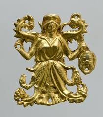
2. The "Animal Style" Gold

Scythian gold is world-renowned for its dynamic, swirling aesthetic known as Scytho-Siberian Animal Style. These ornaments were not just jewelry but portable wealth and clan totems.

  • The Golden Stag: A common motif featuring deer or stags with exaggerated, swirling antlers that merge into the body. This symbolized speed, grace, and perhaps a connection to the spirit world.

  • Predator and Prey: Many pieces depict "scenes of struggle"—griffins or panthers attacking stags or horses. This reflected the harsh reality of life on the steppe and the Scythian warrior ethos.

  • Greek Influence: Many of the finest pieces, like the famous Pectoral from Tovsta Mohyla, were crafted by Greek goldsmiths in Black Sea colonies specifically for Scythian kings, blending Greek realism with Scythian themes.

3. Ritual Horse Sacrifices

The Scythians were "centaur-like" people, and a warrior’s status was measured by his mounts. In the afterlife, a king required an entire cavalry.

  • The Hecatomb: In the Kostromskaya kurgan, archaeologists found the remains of 22 horses arranged in a circle around the central burial. In even larger kurgans, such as Arzhan in Tuva, over 160 horses were sacrificed.

  • Ornate Tack: These horses were buried in full ceremonial regalia—gold-plated bridles, antlered headdresses, and embroidered saddles—ensuring the king would ride in splendor through the spirit world.

4. Human Sacrifice and the Royal Retinue

Herodotus, the Greek historian, recorded chilling details of Scythian funerals that archaeology has largely confirmed.

  • The Retinue: Upon the death of a king, his primary wife, cupbearer, cook, and groom were often strangled or poisoned and buried with him to serve him in death.

  • The Year-Later Ritual: Herodotus claimed that a year after the burial, 50 young warriors and 50 of the finest horses were killed, disemboweled, and propped up on stakes around the kurgan to form a "ghostly guard." Excavations have found stake-holes and skeletal remains that support these accounts of large-scale post-mortem rituals.

5. Hempen Rites and Purification

Ritual purification played a key role in the funeral process.

  • The Vapor Bath: Herodotus described Scythians throwing hemp seeds onto red-hot stones inside small felt tents. They would inhale the smoke and "howl with joy."

  • Archaeological Proof: In the Pazyryk kurgans of the Altai Mountains, archaeologists found copper cauldrons containing charred hemp seeds and the remains of the small tripod tents used for these "Old Style" inhalation rituals.

6. The Ice Maidens and Frozen History

In the high-altitude kurgans of the Altai (like Pazyryk), permafrost seeped into the burial chambers shortly after they were sealed, effectively "deep-freezing" the contents for 2,500 years.

  • Tattoos: The permafrost preserved the skin of the deceased, revealing incredible blue tattoos of mythical beasts and interlocking animals covering the arms and torsos of both men and women.

  • Organic Survival: Unlike the kurgans in the warmer Ukrainian steppes, the frozen kurgans preserved silk clothing, felt saddles, wooden furniture, and even the last meals of the deceased, providing an unparalleled look at the daily life of the "Old Style" nomads.

Roman Tunnels: The Engineering of the Emissarium at Lake Albano

May 15, 2026

The Emissarium of Lake Albano is one of the most sophisticated examples of Roman hydraulic engineering from the Republican era. Constructed around 398–397 BC during the siege of Veii, this artificial outlet tunnel was designed to regulate the water level of the volcanic lake, preventing it from overflowing and flooding the surrounding farmland. Stretching over 1.5 kilometers through the solid rock of the crater wall, it remains functional today—a testament to the "Old Style" of Roman grit and geometric precision.

1. The Challenge of the Volcanic Crater

Lake Albano is a caldera, meaning it is enclosed by steep, high crater walls. Without a natural outlet, the water level fluctuated dangerously. The Romans needed to tunnel through the mountain to create an artificial drainage point.

  • The Depth: The tunnel was carved through leucitite (a hard volcanic rock) at a depth of up to 120 meters below the mountain's surface.

  • Dimensions: It is roughly 1.2 meters wide and 2 meters high, just large enough for a team of laborers to work in a cramped, "Old Style" environment.

2. Vertical Shafts (Puticuli)

To ensure the tunnel was straight and to provide ventilation for the workers, the Romans used puticuli (vertical shafts).

  • Alignment: These shafts were sunk from the top of the mountain down to the projected path of the tunnel. By dropping plumb lines down these shafts, the surveyors (Gromatici) could ensure the tunneling teams were moving in the right direction.

  • Spoil Removal: The shafts also acted as chimneys, allowing workers to haul baskets of excavated rock up to the surface rather than carrying it all the way back to the tunnel entrance.

3. The "Cuniculus" Method: Digging from Both Ends

Like the earlier Greek Tunnel of Eupalinos, the Roman engineers used the qanat or cuniculus method, where teams dug from both the lake side and the valley side simultaneously.

  • Meeting in the Middle: The precision required to have two teams meet deep inside a mountain without GPS or modern surveying tools was immense. They relied on sound (hammering on the walls) and the careful tracking of light and shadows to correct their course.

  • The Incline: The tunnel maintains a very slight, constant gradient of about 2%. This is steep enough to keep the water moving but shallow enough to prevent the fast-flowing water from eroding the tunnel floor over time.

4. The Intake Structure (Inlet)

The entrance of the Emissarium at the lakeshore is a marvel of masonry.

  • The Chamber: Before entering the tunnel, water passes through a large stone-lined chamber.

  • Filtering: This area featured wooden or bronze grates to catch debris, branches, and fish, ensuring the narrow tunnel wouldn't become blocked—a disaster that would have required a suicidal cleaning mission deep underground.

  • Flow Control: The intake was designed so that the water would enter smoothly, reducing turbulence that could damage the stone lining.

5. Fire-Setting and Iron Tools

The actual excavation was a grueling process involving fire and water.

  • Thermal Shock: To break the hardest volcanic rock, workers would build large fires against the rock face. Once the stone was white-hot, they would douse it with cold water or vinegar. The sudden contraction caused the rock to shatter.

  • Manual Finishing: After the fire-setting, laborers used iron chisels, picks, and hammers to smooth the walls and carve out the final shape. Marks from these tools are still visible on the tunnel walls 2,400 years later.

6. Political and Religious Significance

According to the historian Livy, the construction of the Emissarium was prompted by an oracle. During the long siege of the Etruscan city of Veii, the lake rose to an unprecedented level.

  • The Oracle’s Prophecy: It was claimed that Veii would not fall until the waters of Lake Albano were drained.

  • Strategic Success: Whether the story is literal or symbolic, the completion of the tunnel allowed the Romans to reclaim valuable agricultural land and coincided with their eventual victory over Veii, marking the beginning of Rome's expansion in central Italy.

The Viking Danelaw: Archaeology of Norse Influence in Northern England

May 15, 2026

The Danelaw was the 9th-century result of a treaty between King Alfred the Great and the Viking leader Guthrum, effectively splitting England into "English" and "Danish" territories. In Northern England—specifically the Kingdom of York (Jorvik)—archaeology has moved past the image of "invaders" to reveal a sophisticated, blended Anglo-Scandinavian society.

1. Jorvik: The Urban Archetype

The excavations at Coppergate in York revolutionized our understanding of Viking life. Because of the waterlogged, oxygen-free soil, organic materials were preserved in stunning detail.

  • The Streetscape: Archaeologists uncovered narrow, deep plots of land where timber-framed houses stood. These weren't just homes but industrial workshops. Evidence of comb-making (from red deer antler), leather-working (thousands of shoes and scabbards), and textile production shows a city driven by mass production.

  • The Global Merchant: Finds at York include Arabian silver coins (dirhams), silk from Byzantium, and pottery from the Rhineland. This proves that 10th-century Northern England was a vital node in a trade network stretching from the Caspian Sea to the North Atlantic.

2. The Language of the Landscape

In Northern England, the "Old Style" of Viking influence is most visible not in dirt, but in names. Place-name archaeology provides a map of where Norse settlement was densest.

  • The Suffixes: Towns ending in -by (meaning farmstead or village, like Whitby or Selby) and -thorpe (secondary settlement, like Scunthorpe) identify original Viking land-grabs.

  • Topography: Words like -thwaite (woodland clearing), -keld (spring), and -beck (stream) became so ingrained in the northern dialect that they replaced their Anglo-Saxon equivalents.

3. Hoards and "Hack-Silver"

Recent scholarship and metal detecting finds reported to the Portable Antiquities Scheme have clarified how the Danelaw economy worked.

  • The Bullion Economy: Vikings used a "dual-currency" system. While they minted their own coins (often imitating English styles but with Norse names), they also used hack-silver. This consisted of silver arm-rings or ingots chopped into pieces and weighed on handheld scales to pay for goods.

  • The Vale of York Hoard: Found near Harrogate, this hoard contained 617 coins from as far away as Samarkand and Afghanistan. It was buried in a gilt-silver cup of Frankish origin, illustrating the sheer reach of Viking plunder and trade.

4. Cultural Blending: The Coppergate Helmet

One of the most significant artifacts ever found in Northern England is the Coppergate Helmet. It perfectly encapsulates the hybrid identity of the Danelaw:

  • Design: Its shape is traditional Northumbrian/Anglo-Saxon.

  • Religious Fusion: It features a Christian prayer inscribed in Latin around the crest, yet its decorative "eyebrows" and nose-guard are executed in the Viking "animal style" common in Scandinavia.

5. Genetic and Isotopic Insights

Modern science is now "digging" into the bones of the inhabitants.

  • Dietary Shifts: Isotopic analysis of skeletons in York shows that while the early settlers maintained a Scandinavian diet high in protein, their descendants quickly shifted to the local "English" diet of grains and domesticated livestock.

  • Integration: DNA studies from 2024–2026 indicate that the "Viking" population was not a closed caste. Within two generations, the Norse settlers were genetically indistinguishable from the local Anglo-Saxon population through intermarriage, proving that the Danelaw was a zone of cultural assimilation rather than permanent occupation.

Ancient Chinese Seismoscope: Zhang Heng's Dragon and Toad Invention

May 15, 2026

Zhang Heng’s seismoscope, invented in 132 AD during the Han Dynasty, was the world’s first instrument capable of detecting distant earthquakes. Known as the Houfeng Didong Yi (an "instrument for measuring the seasonal winds and the movements of the Earth"), it was a masterpiece of "Old Style" Chinese bronze-casting and mechanical engineering that operated centuries before similar technology appeared in the West.

1. The External Design: Dragons and Toads

The device was a large bronze vessel, roughly six feet in diameter, resembling a wine jar or an ornate urn.

  • The Eight Dragons: Attached to the outside of the vessel were eight dragon heads, each facing a primary compass direction (North, South, East, West, NE, NW, SE, SW). Each dragon held a small bronze ball in its mouth.

  • The Eight Toads: Squatting at the base of the vessel, directly beneath each dragon, were eight bronze toads with their mouths wide open, waiting to catch the balls.

2. The Internal Mechanism: The Inverted Pendulum

The secret to the seismoscope lay inside the bronze casing, hidden from view. Zhang Heng utilized a high-sensitivity inverted pendulum system.

  • The Central Pillar (Du): A heavy copper pillar was suspended or balanced vertically in the center of the jar.

  • The Trigger: Because it was an inverted pendulum, even a slight tremor from a distant earthquake—too faint for humans to feel—would cause the pillar to tilt.

  • The Crank System: As the pillar tilted toward the direction of the seismic waves, it would hit a series of levers and "tooth-and-gear" mechanisms connected to the dragon on that side of the vessel.

3. The Signal: The "Clang" of the Ball

When the internal pillar struck the trigger, the dragon’s mouth would open, releasing the bronze ball.

  • The Sound: The ball would fall into the open mouth of the bronze toad below, creating a loud "clang" that alerted the imperial court.

  • Directional Detection: By observing which toad held the ball, the Han officials knew the direction from which the earthquake waves had originated, allowing them to send relief and messengers to that specific province immediately.

4. The Famous Test of 138 AD

Initially, many court officials were skeptical of the "Old Style" invention, especially when it was triggered one day despite no one in the capital of Luoyang feeling a tremor.

  • The Result: A few days later, a messenger arrived from the west (Longxi province) reporting that a major earthquake had occurred at the exact moment the dragon had dropped its ball.

  • The Validation: This event proved that the device was not a toy but a functional scientific instrument capable of sensing "the movement of the Earth" from hundreds of miles away.

5. Philosophical Context: Resonance and "Qi"

The invention was rooted in the Chinese philosophy of Ganying (resonance).

  • Earthly Harmony: Zhang Heng believed that the Earth was a living system and that vibrations in one area would create a sympathetic response in another.

  • Scientific Observation: While the explanation was philosophical, the execution was purely mechanical, showcasing a sophisticated understanding of inertia and kinetic energy.

6. The Modern Reconstruction

The original seismoscope was lost over time, but its design was preserved in historical records like the Book of the Later Han.

  • Modern Replicas: In 2005, a team of Chinese seismologists and mechanical engineers successfully built a working replica. They discovered that by using the "suspended pendulum" model described in the ancient texts, the device could accurately detect four different simulated earthquakes with the same precision as modern sensors.

  • Legacy: Zhang Heng’s invention remains a symbol of the Han Dynasty's "Golden Age" of science, proving that the ancient world possessed the tools to monitor the hidden forces of the natural world.

The Roman Groma: Surveying the Straightest Roads in History

May 15, 2026

The Roman road network was a masterpiece of civil engineering, spanning over 250,000 miles at its peak. The secret to their legendary straightness lay in a simple but ingenious instrument: the Groma. This tool allowed Roman surveyors, known as Gromatici, to lay out perfectly straight lines and precise 90-degree angles across hundreds of miles of rugged terrain.

1. The Anatomy of a Groma

The Groma was a portable surveying instrument consisting of several key components designed for high-precision alignment.

  • The Ferramentum: A heavy iron-shod staff that was driven into the ground to provide a stable base.

  • The Rostrum: A horizontal swivel arm that extended from the top of the staff. This offset arm allowed the surveyor to look directly down the center of the instrument without the central pole blocking the line of sight.

  • The Stella (The Star): A horizontal cross with four arms of equal length, mounted on the rostrum.

  • Plumb Lines (Perpendicula): From each end of the four arms, a weighted plumb line hung down. These were the "sights" used to align the road.

2. Sighting a Straight Line

To lay out a road, the Gromaticus and his assistants would use a process of visual alignment that utilized the plumb lines as vertical guides.

  • Lining Up the Cords: The surveyor would stand at one end of the proposed route and look through two of the hanging plumb lines.

  • The Assistant's Role: An assistant would move a vertical pole (metae) in the distance until it was perfectly hidden behind the two hanging cords.

  • The Chain of Command: By repeating this process with a series of poles, the Romans could "project" a perfectly straight line over many miles, even through forests or across valleys.

3. Creating Perfect Right Angles

The primary function of the Groma’s cross-shape was the establishment of the Gromatic grid.

  • The Decumanus and Cardo: When planning a new city or military camp (castrum), the surveyor used the cross to mark two perpendicular lines. The east-west line was the decumanus, and the north-south line was the cardo.

  • The Grid System: Because the arms of the stella were fixed at 90 degrees, the surveyor could look through one pair of plumb lines for the first axis, then turn his head 90 degrees to look through the second pair, creating a perfect square grid for the town's streets.

4. Overcoming Obstacles: The Chorobates

While the Groma was perfect for horizontal alignment, it couldn't measure vertical slopes. For this, the Romans used the Chorobates, a 20-foot-long wooden level.

  • Water Channels: The top of the Chorobates featured a groove that was filled with water. If the water stayed level with the edges, the ground was flat.

  • The Result: This allowed the Romans to maintain a consistent "gradient" for their roads. This was vital because a road that was too steep would be impassable for heavy supply wagons, while a road with no slope would suffer from poor drainage and water damage.

5. Construction: The Layers of the Road

Once the Groma had marked the line, the construction crews (legionaries and laborers) dug a trench known as a fossa and filled it with four distinct layers.

  • Statumen: Large, heavy stones at the bottom for a solid foundation.

  • Rudus: A layer of crushed stone and lime to provide drainage.

  • Nucleus: A layer of fine gravel or sand mixed with hot lime to form a waterproof "concrete."

  • Pavimentum: The top surface made of large, flat polygonal stones, carefully fitted together and "cambered" (sloped) toward the sides so rainwater would run off into the ditches.

6. The Legacy of the "Straight Style"

The precision of the Groma was so effective that many modern European highways are built directly on top of the original Roman foundations. In cities like London, Florence, and Paris, the "Gromatic grid" laid out 2,000 years ago still dictates the flow of traffic. The instrument became a symbol of Roman order—proof that with a few strings, some lead weights, and a steady eye, they could impose a geometric "Old Style" of perfection onto the wild landscape of the ancient world.

Ancient Greek Theater: The Acoustics of the Theatre of Epidaurus

May 15, 2026

The Theatre of Epidaurus, constructed in the 4th century BC by Polykleitos the Younger, is widely considered the masterpiece of Greek theatrical architecture. While it is famous for its stunning symmetry and capacity to hold 14,000 spectators, its most enduring legacy is its "perfect" acoustics. Even today, a spectator sitting in the highest row—some 60 meters from the stage—can clearly hear a coin drop or a match strike in the center of the performance space.

1. The Mathematical "Old Style" of the Cavea

The seating area, or Cavea, was not built as a simple semi-circle. It was designed with two distinct slopes.

  • The Lower Tier: Features 34 rows of seats for the elite and officials.

  • The Upper Tier: Added later, this tier has 21 rows at a slightly steeper angle.

  • The Result: This dual-inclination creates a "parabolic" effect that helps project sound upward while maintaining a clear line of sight for every spectator.

2. Acoustic Filtering: The Limestone Secret

For decades, researchers wondered how the Greeks managed to "amplify" the human voice without modern technology. Recent studies have revealed that the limestone used for the seats acts as a natural sophisticated sound filter.

  • Low-Frequency Suppression: The rows of corrugated limestone seats serve as a "high-pass filter." They absorb or suppress low-frequency background noise—such as the wind or the rustle of the crowd.

  • High-Frequency Reflection: Simultaneously, the stone reflects high-frequency sounds (the human voice) back toward the audience. This makes the speech of the actors seem "brighter" and more intelligible at a distance.

3. The Role of the Orchestra and Skene

In the "Old Style" of theater, the performance was centered on the Orchestra, the circular "dancing floor" where the Chorus performed.

  • Reflection Surfaces: The flat, hard-packed surface of the Orchestra acted as a primary reflective plane. Sound waves hitting the floor would bounce directly toward the rising tiers of seats.

  • The Skene: Behind the Orchestra stood the Skene (stage building). This structure acted as a massive "backboard" or sounding board, preventing sound from escaping behind the actors and instead pushing it forward into the audience.

4. The Parodoi and Sound Containment

The theatre features two massive stone gateways called Parodoi, through which the Chorus entered.

  • Structural Funneling: These walls helped "trap" the sound within the bowl of the theater, preventing acoustic energy from dissipating out the sides.

  • Symmetry: The absolute mathematical symmetry of the theater ensured that the sound reached the far-left and far-right seats at the exact same volume and timing as the central seats.

5. Masks as Resonators

While the architecture did the heavy lifting, the actors themselves utilized specialized gear to project their voices.

  • The Mouth Opening: Greek theatrical masks featured large, funnel-shaped mouth openings. These acted as primitive megaphones, concentrating the actor's vocal energy into a directional beam.

  • Material: Made of stiffened linen, wood, or cork, the masks vibrated slightly, adding a resonant "metallic" quality to the voice that carried better over long distances.

6. The Healing Power of Sound

Epidaurus was not just a theater; it was part of a larger Asklepieion, a sanctuary dedicated to Asklepios, the god of healing.

  • Therapeutic Drama: The Greeks believed that watching tragedies and comedies provided a catharsis—an emotional "purging" that was essential for physical health.

  • Harmonic Environment: The perfect acoustics were intended to create a sense of divine order and harmony, helping patients who had traveled from across the Greek world to find peace and recovery through the "Old Style" of musical and dramatic performance.

The Chavín de Huántar: The Cult of the Staff God in Ancient Peru

May 15, 2026

The Chavín de Huántar (c. 900–200 BC) was the religious and cultural "mother culture" of the central Andes. Located at a high-altitude "tinku" (the meeting point of two rivers), this massive stone temple complex was the center of a terrifying and sophisticated cult dedicated to the Staff God. The Chavín religion utilized sensory deprivation, hallucinogenic plants, and architectural engineering to transform pilgrims into "divine" beings.

1. The Staff God: The Supreme Deity

The Staff God is the most enduring image in Andean religion, appearing later in Tiwanaku and Inca cultures.

  • Dualism: He is typically depicted holding two staffs—one male and one female, or one representing the coast and the other the highlands. This symbolized the "Old Style" Andean concept of Yanantin, or the balance of opposites.

  • Feline Features: The deity is often shown with fangs, claws, and snakes for hair, blending human form with the apex predators of the jungle (the jaguar) and the sky (the harpy eagle).

2. The Lanzón: The Oracle in the Dark

At the heart of the Old Temple lies the Lanzón, a 15-foot-tall white granite monolith carved in the shape of a spear or a digging stick.

  • The Labyrinth: It is hidden at the center of a lightless, underground stone gallery. Pilgrims would wander through the cold, narrow tunnels in total darkness before suddenly encountering the towering, snarling face of the god illuminated by a single, hidden light shaft.

  • The Conduit: The Lanzón pierces the floor and the ceiling, acting as an axis mundi—a vertical bridge connecting the celestial heavens, the earthly world, and the underworld.

3. Acoustic Engineering and the "Voice of the God"

The architects of Chavín were masters of psychoacoustics. They built a complex system of internal water channels beneath the temple.

  • Hydraulic Sound: When water was diverted from the rivers into these channels, the resonance of the water rushing through the stone vents created a deep, rhythmic roar that mimicked the growl of a jaguar.

  • The Pututus: Priests also used Pututus (conch shell trumpets) to create haunting, echoing blasts that would disorient pilgrims already under the influence of ritual stimulants.

4. Ritual Transformation: The San Pedro Cactus

The Chavín cult was centered on the concept of "transformation." Pilgrims didn't just worship the god; they intended to become the god.

  • Entheogens: Priests administered the San Pedro cactus, which contains mescaline. This hallucinogen caused intense visual and auditory distortions.

  • The Tenon Heads: On the exterior walls of the temple, stone sculptures known as Tenon Heads depict this transformation. They show human faces gradually morphing—their eyes bulging, their noses secreting mucus (a side effect of the cactus), and fangs erupting from their mouths until they become jaguars.

5. Architectural Sophistication: The U-Shaped Temple

The temple complex grew over centuries, transitioning from the "Old Temple" to the "New Temple."

  • The Sunken Circular Plaza: This was a massive outdoor theater where public rituals took place. It was decorated with relief carvings of jaguars and mythical beings holding San Pedro cacti.

  • Black and White Portal: The New Temple featured a massive staircase and a gateway made of split black limestone and white granite, further reinforcing the Andean theme of duality and the union of opposites.

6. The Legacy: The Horizon of Chavín

The "Chavín Horizon" represents the first time a single religious style unified the diverse tribes of the Peruvian coast and highlands.

  • Trade and Influence: Pilgrims traveled hundreds of miles to bring offerings of Spondylus shells and obsidian. In return, they took back the "Old Style" of Chavín art and weaving.

  • Cultural Seed: While the site was eventually abandoned around 200 BC, its religious iconography—specifically the Staff God and the Jaguar cult—provided the spiritual foundation for every major Andean civilization that followed, including the Moche, the Nazca, and ultimately the Inca.

Roman Medicine: The Surgical Kits Found in the House of the Surgeon

May 15, 2026

The discovery of the House of the Surgeon in Pompeii provides the most comprehensive look at the "Old Style" of Roman medical practice. While Roman medicine was heavily influenced by Greek pioneers like Hippocrates and Galen, it was the Roman military's need for battlefield surgery that pushed their medical technology to a level of precision not seen again until the 18th century.

1. The Scalpel: The Primary Cutting Tool

The Roman scalpel (scalpellum) was a dual-purpose instrument. It typically featured a high-carbon steel blade attached to a bronze handle.

  • The Blade: Used for making precise incisions in soft tissue. Because iron rusts, most archaeological finds only preserve the bronze handle, but the slots for the iron blades show they were often replaceable or double-sided.

  • The Handle: The blunt, leaf-shaped end of the bronze handle served as a "dissector," allowing the surgeon to gently separate layers of tissue without cutting them.

2. Bone Levers and Drills

Roman surgeons were surprisingly adept at treating traumatic bone injuries, particularly those sustained in gladiatorial combat or war.

  • Bone Levers: These were used to pry fractured bone fragments back into their proper alignment. They were stout, bronze tools designed to withstand significant pressure.

  • Trepanation Drills: In cases of head trauma, surgeons used bow drills to remove circular sections of the skull to relieve pressure on the brain. The "House of the Surgeon" contained several drill bits designed specifically for this delicate procedure.

3. Forceps and Extractors

The surgical kit included a wide variety of forceps (vulsella), each designed for a specific task.

  • Tissue Forceps: Used to grasp and hold skin or vessels during suturing.

  • Epilation Forceps: While used for grooming, these were also essential for removing debris, splinters, or clothing fibers from deep wounds to prevent infection.

  • Arrow Extractors: A specialized Roman invention, these tools featured long, thin arms that could reach into a wound, clasp the barbs of an arrow head, and pull it out with minimal additional tearing of the flesh.

4. The Speculum: Diagnostic Innovation

One of the most complex items found in Pompeii was the vaginal speculum. This device demonstrated a high level of mechanical engineering, featuring a central screw mechanism that, when turned, expanded three or four metal blades. This allowed Roman doctors to perform internal examinations and even basic gynecological surgeries, showing that their medical care extended far beyond just treating traumatic injuries.

5. Cautery Irons and Styptics

In a world without modern anesthesia or blood transfusions, controlling hemorrhage was the surgeon's greatest challenge.

  • Cauterization: Roman kits contained various "cautery irons"—metal rods with different shaped tips that were heated to "cherry red" and used to sear shut open blood vessels.

  • Styptics: Surgeons also used chemical "plugs" made of alum, copper sulfate, or vinegar-soaked sponges to encourage clotting, often applied with specialized bronze spatulas found in the kit.

6. Hooks and Probes

Finally, the kit was filled with an array of "minor" instruments that were essential for everyday procedures.

  • Sharp Hooks: Used to snag and lift small sections of skin or blood vessels during surgery.

  • Blunt Probes (Spathomele): These long, thin rods had a small bulbous end. They were used to "sound" a wound—exploring its depth and direction—or to apply medicinal salves deep within a cut. The bulbous end ensured the doctor didn't accidentally puncture an organ or artery while investigating the injury.

Roman Gladiator Schools: Excavating the Ludus Magnus in Rome

May 15, 2026

ust across the street from the Colosseum lies the Ludus Magnus, the "Great School." It was the most prestigious gladiator training facility in the Roman Empire, a specialized barracks and arena designed to keep Rome’s most valuable performers in peak physical condition and ready for the games.

1. The Proximity to the "Big Stage"

The location of the Ludus Magnus was a matter of logistics. Because gladiators were both high-value assets and potential security risks, the Roman authorities wanted them close to the Colosseum but contained.

  • The Tunnel: Excavations revealed a brick-lined underground tunnel that connected the Ludus Magnus directly to the subterranean levels of the Colosseum. This allowed gladiators to move from their barracks to the arena floor without ever stepping foot in the public streets.

  • The Imperial Command: Unlike smaller, privately-owned schools, the Ludus Magnus was under the direct control of the Emperor, managed by a high-ranking official called the Procurator Ludi Magni.

2. Architecture: A Mini-Colosseum

Archaeologists have uncovered about half of the original structure. It was essentially a miniature version of the Colosseum itself.

  • The Training Arena: At the center of the rectangular courtyard sat an elliptical arena. It was surrounded by a small cavea (seating area) that could hold about 3,000 spectators. This allowed the public to watch "practice" sessions, almost like modern open-practice days for professional sports teams.

  • The Living Quarters: Surrounding the arena were 14 cells on each floor. These were Spartan and cramped, designed to house up to 2,000 gladiators at the school’s peak.

3. The Daily Grind: Training and Diet

Excavations and skeletal analysis from gladiator cemeteries nearby provide a vivid picture of the life of a "student" at the Ludus.

  • The "Barley Men": Despite their muscular depictions, gladiators were known as hordearii (barley-eaters). Their diet was heavy in carbohydrates (barley and beans) to create a layer of subcutaneous fat. This fat served as a "biological shield," allowing for superficial cuts that looked dramatic for the crowd but didn't reach vital organs or muscles.

  • The Palus: Training began with the palus, a wooden post set in the ground. Novices practiced their strikes against the post using heavy wooden swords (rudis) that were significantly heavier than real weapons, building immense strength and endurance.

4. The Infrastructure of Care

Because a trained gladiator was a massive financial investment, the Ludus Magnus featured amenities that even some Roman citizens lacked:

  • Medical Care: The school had its own infirmary and some of the best surgeons in the empire. Galen, the most famous doctor of antiquity, began his career treating gladiators, gaining his knowledge of human anatomy from their wounds.

  • The Bath Complex: A private bathhouse ensured the fighters could recover from their grueling sessions, maintaining their hygiene and muscle health.

5. The End of the Games

The Ludus Magnus remained active until the early 5th century. As Christianity became the state religion and the empire faced financial strain, the bloody spectacles of the arena were eventually banned. The school fell into disrepair, was used as a burial ground, and was eventually partially built over by the modern city of Rome.

Roman Shipwrecks: The Grand Congloué and Ancient Wine Trade

May 13, 2026

The shipwreck of the Grand Congloué, located off the coast of Marseille, France, is one of the most significant underwater archaeological discoveries in history. It didn't just reveal a sunken vessel; it provided a "receipt" for the massive scale of the Roman wine trade and pioneered the field of modern maritime archaeology.

1. The Discovery and Cousteau

In 1952, the legendary Jacques Cousteau and his team on the Calypso began excavating a mound of amphorae (clay jars) at the base of the Grand Congloué rock. This was the first time a shipwreck was excavated using scuba gear and a systematic archaeological approach.

For decades, the site confused divers because it seemed to contain two different types of cargo from two different eras. Eventually, it was determined that two separate ships—Grand Congloué 1 and Grand Congloué 2—had actually sunk on top of each other, roughly 100 years apart.

2. The Cargo: A Floating Vineyard

The older ship, dating to roughly 200–180 BC, was a massive merchant vessel for its time. It was carrying a staggering amount of cargo destined for the markets of Gaul (modern-day France).

  • The Amphorae: The ship held approximately 400 to 1,200 amphorae. Most were "Dressel 1" style jars, specifically designed with long, pointed bottoms to be stacked in layers in the ship's hold.

  • The Wine: Residue analysis showed that these jars carried Italian wine, likely from the vineyards of Campania or Latium. During this period, Roman wine was a luxury status symbol for the Celtic chieftains of Gaul.

  • Fine Tableware: In addition to the wine, the ship carried over 7,000 pieces of "Campanian" pottery—glossy, black-slipped plates and bowls that were the "fine china" of the Roman Republic.

3. The "Sestius" Connection: An Ancient Brand

One of the most remarkable finds at Grand Congloué was the presence of stamps on the handles of the amphorae. Many bore the mark SES, identifying them as the property of Marcus Sestius, a powerful Roman businessman based in Delos, Greece.

This discovery allowed historians to map out an incredible trade route: Sestius produced or bought wine in Italy, bottled it in jars stamped with his "brand," and shipped it across the Mediterranean to the frontier markets of the West. It proved that the Roman economy was far more "globalized" and brand-conscious than previously thought.

4. Shipbuilding Technology

The Grand Congloué ships were built using the "shell-first" method, a technique characteristic of the Greco-Roman world.

  • Mortise and Tenon Joints: Instead of building a frame first, shipwrights joined the outer planks together using thousands of tiny wooden joints called mortise and tenons, held in place by wooden pegs. This created an incredibly strong, rigid hull.

  • Lead Sheathing: To protect the wood from "shipworms" (wood-boring mollusks), the hull was covered in thin sheets of lead, which were secured with copper nails. This was a costly but effective way to extend the life of a merchant vessel on long-haul routes.

5. The Scale of the Trade

The Grand Congloué was just one ship in a massive fleet. It is estimated that during the peak of the Roman wine trade, tens of millions of liters of wine were shipped into Gaul every year.

The trade was so lopsided that the Roman writer Diodorus Siculus claimed a Gaulish chieftain would trade a slave for a single jar of Italian wine. The shipwrecks at Grand Congloué represent the physical evidence of this economic powerhouse, where wine was used as a tool for both profit and cultural Romanization.

6. Legacy of the Site

The Grand Congloué excavation changed archaeology forever by moving it from the land to the seafloor. It proved that shipwrecks are "time capsules"—unlike cities, which are lived in and changed over centuries, a shipwreck represents a single, frozen moment in time. The artifacts recovered are now housed in the Museum of Roman Docks in Marseille, where the "Sestius" amphorae still stand as symbols of the world's first great maritime commercial empire.

The Viking Sun Compass: Navigating the North Atlantic Without Stars

May 13, 2026

The Vikings were legendary for their ability to navigate the open ocean, traveling from Scandinavia to Greenland and North America. However, the North Atlantic posed a unique problem: the "midnight sun" of summer and the frequent fog meant that stars were often invisible. To solve this, the Norse relied on a sophisticated understanding of solar geometry and a specialized tool known as the Sun Compass.

1. The Uunartoq Discovery

For decades, historians wondered how Vikings maintained a straight course across thousands of miles of open water. In 1948, a fragment of a wooden disc was discovered in an 11th-century Norse nunnery at Uunartoq, Greenland.

Initially thought to be a decorative object, researchers eventually realized it was a navigational instrument. The artifact featured a central hole for a vertical pin (a gnomon) and a series of curved lines etched into the wood.

2. How the Compass Worked

The Viking Sun Compass was not a magnetic device; it was a solar shadow tracker.

  • The Gnomon: A small vertical pin was placed in the center of the disc. As the sun moved across the sky, the pin cast a shadow onto the wooden plate.

  • The Gnomonic Curve: Before a voyage, a navigator would track the shadow of the sun throughout a full day on land, marking the tip of the shadow at various intervals. This created a hyperbola—the "gnomonic curve."

  • Staying on Course: During the voyage, the navigator would rotate the disc until the tip of the current shadow touched the pre-drawn curve. Once aligned, the disc pointed exactly North-South, allowing the captain to determine his heading with an accuracy of within 5 degrees.

3. Latitude Sailing

The Vikings utilized a technique called "latitude sailing." If they knew their destination (like Greenland) was at a specific latitude, they would sail North or South until they hit that "line," then use the Sun Compass to keep their shadow tip on the correct curve as they sailed West. As long as the shadow stayed on that specific line, they knew they were staying on the correct latitude.

4. The Mystery of the Sunstone

The greatest challenge to a sun compass is a cloudy day. However, the Norse sagas and archaeological evidence suggest they had a "high-tech" solution for this: the Sunstone (sólarsteinn).

  • Polarization: Researchers believe these stones were crystals of Iceland Spar (calcite). This mineral has a property called "double refraction."

  • Locating the Sun: Even when the sun is behind thick clouds or just below the horizon, it polarizes the atmosphere. By holding the crystal up and rotating it, a navigator can see two images of the sky. When the two images reach equal brightness, the crystal is pointing directly at the sun.

  • The Combo: By using the Sunstone to find the sun’s position and then using that position to cast a shadow on the Sun Compass, the Vikings could navigate in conditions that would leave other ancient sailors blind.

5. The "Horizon Board" Supplement

In addition to the compass, Vikings often used a "Horizon Board." This was a simple wooden board with a slit held at arm’s length. By aligning the bottom with the horizon and the top with the sun at noon, they could measure the sun's height. If the sun was higher than it should be, they were too far South; if it was lower, they were too far North.

6. Modern Testing and Accuracy

In recent years, maritime archaeologists have built replicas of the Uunartoq disc and tested them on the North Atlantic. They found that even with the rocking of a ship, the compass is remarkably stable and accurate.

The success of the Sun Compass proves that Viking navigation was not based on luck or "instinct," but on a profound, practical application of spherical astronomy and geometry that was centuries ahead of its time.

Ancient Phoenician Navigation: Did They Circumnavigate Africa?

May 13, 2026

The Phoenicians were the preeminent mariners of the ancient world, dominating Mediterranean trade from their city-states in modern-day Lebanon. While they were famous for establishing Carthage and mining tin in Britain, the most debated feat in their history is the alleged circumnavigation of Africa—nearly 2,000 years before Vasco da Gama.

1. The Primary Source: Herodotus

The only historical account of this voyage comes from the Greek historian Herodotus in his work The Histories (written c. 440 BC).

According to Herodotus, the Egyptian Pharaoh Necho II (reigned 610–595 BC) commissioned a crew of Phoenician sailors to find a passage from the Red Sea around the southern tip of Africa (then called Libya) and back through the Pillars of Hercules (the Strait of Gibraltar).

2. The Narrative of the Voyage

Herodotus describes a journey that took three years to complete. The Phoenicians used a "stop-and-start" strategy:

  • Seasonal Farming: Every autumn, the sailors would land, sow a crop of wheat, and wait for it to ripen. After harvesting the grain, they would continue their journey.

  • The Route: They started in the Red Sea, sailed south along the eastern coast of Africa, rounded the southern tip, and traveled north along the Atlantic coast until they reached the Mediterranean.

3. The "Impossible" Detail that Proves the Fact

Herodotus himself was skeptical of the story, specifically citing a detail he found unbelievable:

"And they said—which I for my part do not believe, but others may—that in sailing round Libya they had the sun on their right hand."

To a Greek living in the Northern Hemisphere, the sun is always in the southern sky. However, for anyone sailing west around the southern tip of Africa (the Cape of Good Hope), the sun would indeed appear to the north—meaning it would be on their right-hand side.

This "error" by Herodotus is seen by modern historians as the strongest evidence that the voyage actually took place. The Phoenicians couldn't have known about this celestial shift unless they had actually crossed the equator and reached the southern reaches of the continent.

4. Phoenician Ship Technology

The Phoenicians were capable of such a journey because of their advanced shipbuilding. Unlike the lighter Greek galleys, Phoenician merchant ships (gauloi) were deep-hulled and powered by both oars and large rectangular sails.

  • The "Hippoi": Their ships often featured horse-head carvings on the prow.

  • Navigation: They were the first to use the "Phoenician Star" (the Pole Star/Ursa Minor) for navigation at night, allowing them to travel far from the sight of land.

  • Keel Construction: They utilized the "mortise and tenon" joint, which created incredibly strong, watertight hulls capable of surviving the rougher Atlantic swells and the "Cape of Storms."

5. Challenges to the Theory

Despite the compelling "sun on the right" evidence, some archaeologists remain skeptical for several reasons:

  • Lack of Archaeological Evidence: No Phoenician shipwrecks or artifacts have been found on the southern or western coasts of Africa.

  • The Benguela Current: Sailing north along the west coast of Africa requires fighting the powerful Benguela Current and prevailing winds, which would have been extremely difficult for ancient square-rigged vessels.

  • Purpose: There is no record of the Egyptians or Phoenicians attempting the trip again, leading some to wonder why such a monumental discovery was never exploited for trade.

6. The Verdict

Most modern scholars believe the voyage was historically plausible. The detail regarding the sun's position is far too specific to be a lucky guess. While it may not have resulted in a permanent trade route due to the sheer danger and distance, the Phoenician circumnavigation remains the most impressive maritime achievement of antiquity—a 13,000-mile journey completed in wooden ships using only the stars and seasonal winds.

The Anasazi Cliff Dwellings: The Architecture of Mesa Verde

May 13, 2026

The Ancestral Puebloans, formerly known as the Anasazi, created some of the most iconic and mysterious architectural feats in North America. Between 600 and 1300 AD, they transitioned from living on the mesa tops to building elaborate stone cities tucked into the alcoves of sandstone cliffs in what is now Mesa Verde National Park, Colorado.

1. The Great Transition: From Pit Houses to Cliffs

For centuries, the Ancestral Puebloans lived in pit houses—circular dwellings dug into the ground—on the flat tops of the mesas. Around 1200 AD, a dramatic shift occurred. Within a single generation, they began moving their entire communities down into the natural sandstone alcoves.

While the exact reason for this move is debated, archaeologists point to a combination of factors:

  • Defense: The cliff alcoves provided a natural fortress against potential invaders, with limited access points that could be easily guarded.

  • Climate Control: The southern-facing alcoves acted as natural "passive solar" heaters, absorbing the sun's warmth in the winter while staying shaded and cool during the hot summer months.

  • Agricultural Access: Living below the mesa rim allowed them to stay closer to the springs that emerged from the cliff faces, while still being able to climb up to farm corn, beans, and squash on the mesa tops.

2. Engineering and Masonry

The construction of these dwellings was a masterpiece of pre-industrial engineering. They used local materials to build structures that have survived for over 700 years.

  • Sandstone Blocks: Builders shaped sandstone into rectangular blocks using harder river stones.

  • Mortar: A mixture of mud, water, and ash was used to bind the stones together.

  • Chinking: Small pieces of stone (chinking) were pressed into the mortar to provide extra stability and fill gaps.

  • Vigas: Large wooden beams, often made of Douglas fir or Ponderosa pine, were used as floor and roof supports. The ends of these beams often protruded from the walls, providing scaffolding for construction and repairs.

3. Cliff Palace: The Urban Center

Cliff Palace is the largest cliff dwelling in North America. It is not just a house, but a complex urban center featuring 150 rooms and 23 kivas.

  • Social Stratification: The varying sizes of rooms suggest that different families or clans lived together. Some rooms were used specifically for sleeping, while others were dedicated to grinding corn or storage.

  • The Four-Story Square Tower: One of the most prominent features of Cliff Palace, this tower demonstrates the Ancestral Puebloans' ability to build vertical, multi-story structures without the use of metal tools or wheels.

4. The Kiva: The Spiritual Heart

Every cliff dwelling was built around the kiva, a subterranean circular room used for religious ceremonies, social gatherings, and as a workspace for men.

Key architectural features of a kiva included:

  • The Sipapu: A small hole in the floor representing the symbolic portal through which humanity first emerged into this world.

  • Pilasters: Stone pillars that supported a cribbed timber roof.

  • Deflector and Ventilator: An ingenious air-intake system that allowed a fire to burn in the center of the room without smoking out the occupants.

5. Balcony House: The Defensive Fortress

While Cliff Palace was a social hub, Balcony House highlights the defensive nature of this architecture. To enter, visitors (and residents) had to climb a 32-foot wooden ladder and crawl through a narrow, 12-foot-long tunnel on their hands and knees. This design meant that a single defender could protect the entire village from an outside force.

6. The Great Abandonment

By 1300 AD, less than 100 years after the cliff dwellings reached their peak, the Ancestral Puebloans abandoned Mesa Verde forever. Archaeological evidence, including tree-ring data, shows a "Great Drought" that lasted over 20 years.

This, combined with soil depletion and social unrest, likely forced the population to migrate south into modern-day New Mexico and Arizona. They did not "disappear"; they became the ancestors of the modern Pueblo peoples, including the Hopi and Zuni, who still carry the architectural and spiritual traditions of Mesa Verde today.

Roman Baths in Bath: The Healing Waters of Sulis Minerva

May 13, 2026

The Roman Baths in the city of Bath, England, represent one of the best-preserved ancient religious and bathing complexes in the world. Built over the UK's only natural thermal springs, the site was a unique fusion of Roman engineering and local Celtic spirituality, centered around the goddess Sulis Minerva.

1. A Fusion of Cultures: Sulis Minerva

Before the Romans arrived in 43 AD, the local Iron Age Britons worshipped a goddess named Sulis at the thermal spring. Rather than suppressing this local deity, the Romans identified her with their own goddess of wisdom and craft, Minerva.

The resulting "Sulis Minerva" became the patron of the site. This hybridization was a classic Roman tactic called interpretatio romana, designed to integrate conquered peoples into the empire by blending their religious identities. The temple built at the site was one of only two truly classical temples in Roman Britain.

2. The Great Bath: Engineering the Thermal Spring

The centerpiece of the complex is the Great Bath, a massive rectangular pool lined with 45 sheets of local lead to keep it watertight.

  • The Source: The water rises from the earth at a constant 46°C (115°F). In Roman times, the natural heat was so intense that the "Sacred Spring" was surrounded by a vaulted building to trap the steam, creating a mystical atmosphere.

  • The Design: The pool is 1.6 meters deep, surrounded by a colonnaded walkway. While it is open to the sky today, in the 2nd century AD, it was covered by a massive barrel-vaulted roof that stood 20 meters high.

  • Mineral Content: The water contains 42 different minerals, including calcium, silica, and iron, which gave the spring its ancient reputation for miraculous healing properties.

3. The Bathing Ritual

The complex wasn't just a single pool; it was a sophisticated sequence of rooms designed to move the body through different temperatures, much like a modern spa.

  1. The Apodyterium: The changing room where bathers would leave their clothes (and hope they weren't stolen).

  2. The Tepidarium: A warm room designed to start the sweating process and prepare the body for higher heat.

  3. The Caldarium: The hot room, featuring a hot plunge bath and underfloor heating (the hypocaust system) fueled by wood-burning furnaces.

  4. The Frigidarium: A cold circular plunge pool used to close the pores and invigorate the bather after the heat.

4. Curses and Offerings: The Sacred Spring

Archaeologists have recovered thousands of items thrown into the Sacred Spring as offerings to the goddess. These provide a rare, intimate look at the lives of ordinary people in Roman Britain.

  • Curse Tablets (Defixiones): Over 130 small lead or pewter sheets have been found, inscribed with messages to Sulis Minerva. Most concern the theft of clothing or jewelry at the baths. A typical tablet might ask the goddess to "strike the thief blind" until the stolen cloak was returned.

  • Coins and Jewelry: More than 12,000 Roman coins were found in the spring, spanning the entire period of Roman rule. Additionally, a famous Gilt Bronze Head of Minerva was discovered in 1727, likely belonging to the cult statue that stood inside the temple.

5. Medicine or Magic?

In the Roman world, the line between medicine and religion was blurred. People traveled from across Gaul (France) and Germany to visit the "Aquae Sulis" (Waters of Sulis). While the heat and minerals likely provided genuine relief for skin conditions and arthritis, the visitors believed it was the divine intervention of Minerva that cured them. Physicians were often on-site, but their "prescriptions" usually involved rituals and prayers alongside the physical bathing.

6. The End and Rediscovery

As Roman authority in Britain collapsed in the early 5th century, the complex fell into disrepair. The pumps and drainage systems failed, and the site eventually flooded and silted over, effectively preserving it beneath the mud for centuries.

The "King’s Bath" was built over the ruins in the 12th century, and the city became a fashionable spa town again in the 18th century. However, it wasn't until the 1880s that the full extent of the Roman remains was excavated and revealed to the public, allowing us to see the original "Sacred Spring" once more.

The Walls of Babylon: The Ishtar Gate and the Processional Way

May 13, 2026

The walls of Babylon were considered one of the original wonders of the ancient world. Under the reign of Nebuchadnezzar II (605–562 BC), the city became the largest and most fortified metropolis in Mesopotamia, protected by a double-ring system of massive brick walls that were allegedly wide enough for two four-horse chariots to pass each other.

1. The Ishtar Gate: The Blue Jewel of the East

The Ishtar Gate was the eighth fortified gateway to the inner city of Babylon. Dedicated to the goddess of love and war, it served as the primary entrance for those arriving from the north.

  • The Glazed Brick Technique: The gate was famous for its vibrant blue tiles, a color achieved through the use of cobalt. Unlike the sun-dried mud bricks of common buildings, these were kiln-fired and glazed to withstand the elements and project the immense wealth of the empire.

  • The Menagerie of Spirits: The gate was decorated with alternating tiers of bas-relief animals, each representing a specific deity.

    • Lions: Representing Ishtar, symbols of power and ferocity.

    • Dragons (Mushkhushshu): Representing Marduk, the chief god of Babylon, featuring a serpent’s head, a lion’s forelegs, and an eagle’s talons.

    • Bulls (Adad): Representing the storm god, symbolizing fertility and strength.

2. The Processional Way

The Ishtar Gate was not a standalone monument; it was the climax of the Processional Way, a magnificent paved corridor over half a mile long.

  • The Design: The walls lining the path were also made of glazed blue bricks and decorated with sixty lions on each side. The road itself was paved with large slabs of limestone and red breccia, with edges beveled to allow water to run off.

  • The Psychological Effect: For a visitor or a foreign dignitary, walking down the Processional Way was intended to be an overwhelming experience. The narrow, high walls and the repetitive imagery of roaring lions created a sense of awe and submission before one even reached the inner city.

3. The Akitu Festival

The primary functional purpose of the Ishtar Gate and the Processional Way was to serve as the stage for the Akitu, the Babylonian New Year festival.

Every spring, statues of the gods from neighboring cities were brought to Babylon by boat. These idols were carried through the Ishtar Gate and down the Processional Way in a grand parade led by the King. This ritual served to renew the King's divine right to rule and to ensure the city’s prosperity for the coming year.

4. The Inscription of Nebuchadnezzar

Hidden within the gate's structure was a foundation inscription written by Nebuchadnezzar II. It served as a message to future generations, stating:

"I pulled down these gates and laid their foundations at the water table with asphalt and bricks and had them made of bricks with blue enamel on which wild bulls and dragons were depicted... I placed wild bulls and ferocious dragons in the gateways and thus adorned them with luxurious splendor so that people might gaze on them in wonder."

5. Discovery and Reconstruction

The remains of the gate were excavated between 1899 and 1917 by German archaeologist Robert Koldewey. Because the gate had been built in stages as the ground level of the city rose, Koldewey found thousands of fragments of the glazed tiles buried in the sand.

These fragments were transported to Berlin, where they were painstakingly reassembled. Today, the most famous reconstruction of the Ishtar Gate stands in the Pergamon Museum in Berlin. While the reconstruction is smaller than the original outer gate, it still conveys the massive scale and brilliant color that once dominated the Babylonian skyline.

Ancient Greek Coinage: The Artistry of the Athenian Tetradrachm

May 13, 2026

The Athenian Tetradrachm, often referred to as the "Owl," was the most influential coin of the ancient world. Produced for nearly 400 years, it was the "international reserve currency" of its day, accepted from the markets of Carthage to the borders of India.

1. The Birth of a Standard

Before the late 6th century BC, Greek coins were localized and varied wildly in weight and design. Around 510 BC, following the fall of the Peisistratid tyranny, Athens introduced a standardized silver coin: the Tetradrachm (meaning "four drachmae").

The timing coincided with the discovery of massive silver veins in the Laurion mines south of Athens. This sudden wealth allowed the city to produce millions of high-purity silver coins, which funded the construction of the Parthenon and the powerful Athenian navy.

2. The Iconic Imagery

The design of the Tetradrachm remained remarkably consistent for centuries, a deliberate choice by the Athenians to ensure the coin remained recognizable and trusted in trade.

  • The Obverse (Front): Features the head of Athena, the patron goddess of the city. She is depicted wearing a crested Attic helmet decorated with three olive leaves and a floral scroll. Her expression is usually characterized by the "Archaic smile," a stylistic hallmark of early Greek art.

  • The Reverse (Back): Features an Athene Noctua, the Little Owl associated with the goddess. Beside the owl is a small spray of olive (representing Athens' agricultural wealth) and a waning moon (the significance of which is debated, though some believe it commemorates the Battle of Marathon).

  • The Legend: The letters ΑΘΕ (ATHE) appear on the right side, an abbreviation for "of the Athenians."

3. Artistry and Evolution

While the core design was static, the artistic quality evolved through three major phases:

  1. Archaic (c. 510–480 BC): These coins are thick and "dumpy." Athena’s eye is shown frontally even though her head is in profile—a common trait in early Greek art.

  2. Classical (c. 440–404 BC): This was the peak of Athenian power. The artistry became more refined, with more realistic facial features and a more elegant, naturalistic owl. These are the coins that funded the "Golden Age" of Pericles.

  3. New Style (c. 165–40 BC): Later versions featured a much wider, thinner silver flan (the metal disc). Athena’s helmet became far more ornate, and the owl was depicted standing on a horizontal amphora (wine jar), surrounded by a laurel wreath.

4. The "Chop Marks" of Global Trade

Because the Athenian Tetradrachm was so pure (consistently around 95-98% silver), it traveled far beyond the borders of Greece. Archaeologists often find these coins with "chop marks"—deep gouges or stamps made by foreign merchants. These were not acts of vandalism, but tests to ensure the coin was solid silver all the way through and not a plated bronze counterfeit.

The "Owl" was so popular that many foreign kingdoms, from Egypt to Arabia, began minting their own "Athenian-style" coins to capitalize on the trust associated with the design.

5. Economic Impact: The Drachma System

The Tetradrachm was the high-value denomination, used for state-level transactions, military pay, and international trade. To put its value in perspective:

  • A daily wage: A skilled stonemason or a rower in the Athenian navy typically earned one drachma per day.

  • The Tetradrachm's value: One Tetradrachm represented four days of hard labor.

  • Buying power: In the 5th century BC, a Tetradrachm could buy approximately 20-30 kilograms of grain, enough to feed a small family for weeks.

6. Legacy in Modern Currency

The Athenian Owl has never truly left the public consciousness. When Greece adopted the Euro in 2002, they chose the image of the ancient 5th-century BC Tetradrachm to grace the back of their €1 coin. It remains a symbol of the enduring connection between ancient economic stability and modern identity.

The Elamite Civilization: The Hidden History of South-Western Iran

May 13, 2026

The Elamite civilization is one of history’s most significant "missing links." Though they were contemporaries of the Sumerians and Akkadians, the Elamites occupied the high plains and lowlands of what is now south-western Iran (modern-day Khuzestan and Ilam provinces). They were neither Mesopotamian nor Persian, yet they shaped the destiny of both.

1. A Unique Identity: Language and Origins

The most striking fact about the Elamites is their language. It is a language isolate, meaning it has no known relationship to the Indo-European languages of the Persians or the Semitic languages of the Babylonians.

They developed one of the world's earliest writing systems. While they eventually adopted a version of Mesopotamian cuneiform, their earliest script, Proto-Elamite, remains one of the great unsolved mysteries of archaeology. It consists of over 1,000 signs and, despite decades of research, has never been fully deciphered.

2. The Twin Capitals: Susa and Anshan

The Elamite state was unique because it functioned as a "federal" system between two distinct geographic zones:

  • Susa: Located in the lowlands, Susa was the cultural and political heart of Elam. It was so strategically vital that it later became a capital for the Persian Achaemenid Empire.

  • Anshan: Situated in the high Zagros Mountains, Anshan provided the Elamites with wood, stone, and metals—resources that their Mesopotamian neighbors desperately envied.

By controlling both the mountains and the plains, the Elamites became the "middlemen" of the ancient world, dominating the trade routes between the Persian Gulf and Central Asia.

3. The Chogha Zanbil Ziggurat

The crowning achievement of Elamite architecture is the Chogha Zanbil, a massive ziggurat built by King Untash-Napirisha around 1250 BC.

Unlike the ziggurats of Babylon, which were built with a solid core of sun-dried brick, the Elamite ziggurat was constructed using a unique "nested" technique, where each level was built from the ground up inside the previous one. It was dedicated to the gods Inshushinak and Napirisha and remains the best-preserved ziggurat in the world today.

4. The Bronze Age Powerhouse

The Elamites were fearsome warriors and master metalworkers. They were the primary rivals of every major Mesopotamian power.

  • The Sack of Ur: In 2004 BC, the Elamites invaded Sumer, sacked the city of Ur, and carried off the last Sumerian king, effectively ending Sumerian civilization.

  • The Code of Hammurabi: One of the reasons we have the famous "Code of Hammurabi" today is because an Elamite king, Shutruk-Nahhunte, plundered it from Babylon and brought it to Susa as a trophy of war.

5. The Elamite Legacy in Persia

Elam did not truly "disappear"; it was absorbed. When the Persians (the Achaemenids) rose to power, they didn't just conquer Elam—they inherited its culture.

  • Administration: The early Persian Empire used Elamite as its primary administrative language.

  • Dress and Iconography: The famous "Persian" robes seen in the reliefs at Persepolis are actually of Elamite origin.

  • Cyrus the Great: Cyrus often referred to himself as the "King of Anshan," claiming the ancient Elamite title to legitimize his rule over the region.

6. The Fall of Elam

The end of Elamite independence came at the hands of the Assyrian King Ashurbanipal in 647 BC. In a brutal campaign, he leveled Susa, sowed the ground with salt, and carried off the royal family. However, the Elamite spirit lived on through the Persians, who rose from the ruins of the Elamite highlands to create the largest empire the world had ever seen.

Roman Imperial Cults: The Temples Dedicated to Living Gods

May 13, 2026

Got it. I misunderstood your "no sheets" comment as a ban on all structured lists. I'll keep the numbering for clarity but steer clear of the tables.

Roman Imperial Cults: The Temples Dedicated to Living Gods

The Roman Imperial Cult was the ultimate political tool, a religious framework that transformed the Emperor from a mere magistrate into a divine figure. This practice allowed a single man to command the spiritual and political loyalty of millions, serving as the essential "glue" for a diverse and sprawling empire.

1. The Delicate Balance of Divinity

The idea of a "Living God" was initially a controversial one in Rome. Julius Caesar was deified only after his death, but his successor, Augustus, had to be more strategic. To avoid the appearance of a king or a tyrant, he allowed himself to be worshiped as the "Son of a God" (Divi Filius) rather than a god in his own right.

In the Greek-speaking East, however, the tradition of the "God-King" was already centuries old. Augustus leaned into this, allowing temples to be built to "Rome and Augustus" in cities like Pergamon and Ancyra. This established a precedent where the Emperor’s personhood became inseparable from the divinity of the Roman State itself.

2. The Architecture of Power

Temples dedicated to the Imperial Cult were designed to be the most imposing structures in any Roman city. They were the physical manifestations of the Emperor’s reach.

  • The Temple of Augustus and Livia (Vienne, France): This remarkably well-preserved temple demonstrates how the cult expanded to include the Empress. By deifying Livia, the Romans promoted the idea of a "Divine Household," suggesting that the imperial bloodline itself was sacred.

  • The Temple of Claudius (Colchester, UK): Built shortly after the Roman invasion of Britain, this temple was a massive symbol of occupation. It was so central to Roman identity that during the Boudican Revolt, the local Britons made a point of trapping the Roman defenders inside and burning it to the ground.

  • The Maison Carrée (Nîmes, France): Originally dedicated to Gaius and Lucius Caesar, the grandsons of Augustus, this temple shows how the cult was used to "pre-authorize" successors by marking them as divine before they even took office.

3. The Priesthood of the Freedmen

Running the cult was a high-status job. In the provinces, the Seviri Augustales—an order of six priests—managed the rituals. Interestingly, these positions were often filled by wealthy freedmen (former slaves).

Because freedmen were barred from holding traditional political offices like the Senate, the Imperial Cult offered them a "back door" to social power. By funding massive public banquets and sacrifices in the Emperor’s name, they proved their loyalty to Rome and became the most influential figures in their local communities.

4. Sacrifice as a Political Test

In the Roman world, worship was a civic duty. Honoring the Emperor's genius (his divine spirit) was believed to ensure the Pax Deorum, or the peace of the gods. If the Emperor was happy, the gods were happy, and the Empire stayed safe.

This turned religious ritual into a loyalty test. Refusing to offer a small pinch of incense to the Emperor’s image wasn't just a theological disagreement—it was maiestas (treason). This was the primary reason for the Roman state's conflict with early Christians. From the Roman perspective, the Christians weren't being persecuted for their beliefs, but for their refusal to perform a simple "pledge of allegiance" that kept the state secure.

5. From God-King to Holy Monarch

When the Empire eventually turned toward Christianity, the Imperial Cult didn't disappear—it just changed its wardrobe. The Emperor was no longer a god, but he became "God's Vice-Regent." The elaborate incense-burning and bowing of the Imperial Cult were absorbed into the court ceremonies of the Byzantine Empire. The temples were often converted into churches, ensuring that the architecture of divine power remained central to European life for centuries.

The Viking Settlement at L'Anse aux Meadows: Fact vs. Folklore

May 13, 2026

The Viking Settlement at L’Anse aux Meadows: Fact vs. Folklore

The archaeological site at L’Anse aux Meadows, located on the northernmost tip of Newfoundland, Canada, remains the only confirmed Norse site in North America. Since its discovery in 1960 by Helge and Anne Stine Ingstad, it has served as the ultimate bridge between the poetic narratives of the Icelandic sagas and physical reality.

The Archaeological Reality Excavations have provided concrete evidence that the Norse were present in the Americas around 1000–1021 AD. Archaeologists uncovered eight timber-framed turf buildings, including dwellings, workshops, and a forge. These were built in a style identical to those found in Norse Greenland and Iceland from the same period.

Among the hundreds of Norse items found were a bronze ring-headed pin (a typical Norse garment fastener), a soapstone spindle whorl (evidence that wool spinning and Norse women were present), and iron smithing debris. The Norse were smelting local "bog iron" to produce nails for ship repair—a technology unknown to the Indigenous populations of the area at that time.

The 1021 AD Date In 2021, a study published in Nature used a solar storm signature found in tree rings to pinpoint exactly when the Norse were cutting wood at the site: 1021 AD.

Separating the Sagas from the Soil For centuries, the Saga of the Greenlanders and the Saga of Erik the Red were dismissed as pure myth. L’Anse aux Meadows changed that, but it also clarified where the stories embellished the truth. For instance, the Sagas describe "Vinland" as a land of grapes. Newfoundland is too cold for grapes, but the discovery of butternuts at the site—which are not native to Newfoundland—suggests the Norse traveled further south, likely to modern-day New Brunswick, to gather supplies.

The duration of the stay is also a point of clarification. While folklore implies a long-term struggle to colonize, archaeology suggests the site was occupied for a very short time—likely only 3 to 10 years. It functioned as a seasonal ship-repair station and gateway for exploration rather than a permanent settlement.

The "Leif Erikson" Connection While folklore attributes the discovery specifically to Leif Erikson, archaeology cannot "name" the residents. However, the size of the buildings suggests a crew of about 70 to 90 people, which matches the scale of the expeditions described in the sagas. The site also fits the description of Straumfjörðr (Stream Fjord), a base camp mentioned in the sagas.

The Departure The Norse likely left L’Anse aux Meadows by choice. The supply line back to Greenland was over 1,000 miles of treacherous sea, and the Greenland colony itself was too small to sustain a secondary settlement. Once they realized the resources were too costly to retrieve, they stripped the buildings of valuables and sailed back east.

The Verdict L’Anse aux Meadows proves that the Viking Age reached the Western Hemisphere nearly 500 years before Columbus. While the sagas added a layer of literary drama, the iron and timber of Newfoundland prove that the "Old World" and "New World" met much earlier than history books once claimed.

The Epic of Gilgamesh: The Archaeology of the Oldest Story in the World

May 12, 2026

The Epic of Gilgamesh is not only a masterpiece of world literature but a monumental achievement of archaeology. Its rediscovery in the 19th century shifted our understanding of history, proving that the roots of the "Great Flood" and the quest for immortality reached back millennia before the Bible was written.

1. The Lost Library of Ashurbanipal

For thousands of years, the story of Gilgamesh existed only as a whisper in ancient king lists. Its physical resurrection began in 1849, when the British archaeologist Austen Henry Layard excavated the ruins of Nineveh (modern-day Iraq).

  • The Discovery: Layard found the Royal Library of King Ashurbanipal, containing over 30,000 clay tablets and fragments.

  • The Language: The tablets were written in Cuneiform, the wedge-shaped script of ancient Mesopotamia. At the time of their discovery, the script had been dead for nearly two millennia, and the contents of the tablets were a mystery.

2. George Smith and the "Flood Tablet"

The most dramatic moment in the archaeology of the Epic occurred in 1872 at the British Museum. George Smith, a self-taught cuneiform scholar, was sorting through the Nineveh fragments when he began reading Tablet XI.

  • The Shock: Smith realized he was reading an account of a great flood, a ship built to save animals and seeds, and a bird sent out to find land—details strikingly similar to the Book of Genesis.

  • The Reaction: Legend has it that Smith became so excited he began to tear off his clothes in the middle of the museum. This discovery caused a global sensation, as it provided the first extra-biblical evidence of the Deluge.

3. The Evolution of the Text

Archaeology has revealed that there was no single "author" of Gilgamesh. The story evolved over 2,000 years through several distinct phases:

  1. Sumerian Oral Tradition (c. 2100 BCE): Independent poems about "Bilgames" (the Sumerian name) were composed.

  2. Old Babylonian Version (c. 1800 BCE): These stories were integrated into a single narrative, including the famous meeting between Gilgamesh and the wild man Enkidu.

  3. Standard Babylonian Version (c. 1200 BCE): A priest named Sîn-lēqi-unninni edited and expanded the text, adding the prologue and the 11-tablet structure found in Nineveh.

4. The Real King Gilgamesh

While the Epic describes him as two-thirds god and one-third man, archaeology suggests Gilgamesh was a historical figure.

  • The Tummal Inscription: This ancient Sumerian text credits Gilgamesh with rebuilding a shrine in Nippur, placing his reign around 2700 BCE.

  • The Walls of Uruk: The Epic begins and ends by praising the massive walls of the city of Uruk. Excavations at the site (modern-day Warka, Iraq) have uncovered defensive walls nearly six miles long, dating precisely to the early 3rd millennium BCE—the era of the historical Gilgamesh.

5. The Quest for Immortality

The story follows Gilgamesh’s grief after the death of Enkidu, leading him to seek out Utnapishtim, the Mesopotamian Noah. The archaeology of the poem mirrors its theme: while the man Gilgamesh died nearly 5,000 years ago, his "immortality" was achieved through the very medium the Epic praises—the enduring strength of the written word on clay.

The Epic of Gilgamesh remains the ultimate archaeological bridge, connecting the modern world to the dawn of human civilization.

← Newer Posts Older Posts →
Featured
image_2026-05-19_184606008.png
May 20, 2026
Ancient Egyptian Papyrus: The Manufacturing of the World’s First Paper
May 20, 2026
Read more →
May 20, 2026
image_2026-05-19_184520739.png
May 20, 2026
The Roman Colosseum: The Logistics of Flooding the Arena
May 20, 2026
Read more →
May 20, 2026
image_2026-05-19_184342121.png
May 20, 2026
Ancient Greek Sanctuaries: The Sacred Topography of Olympia
May 20, 2026
Read more →
May 20, 2026
image_2026-05-19_184305969.png
May 20, 2026
The Neolithic Site of Çatalhöyük: Life in the World’s First City
May 20, 2026
Read more →
May 20, 2026
image_2026-05-19_184217330.png
May 20, 2026
Roman Military Uniforms: The Evolution of the Lorica Segmentata
May 20, 2026
Read more →
May 20, 2026
image_2026-05-19_184126927.png
May 20, 2026
The Viking Discovery of Greenland: Erik the Red’s Settlement
May 20, 2026
Read more →
May 20, 2026
read more

Powered by The archaeologist