• MAIN PAGE
  • LATEST NEWS
    • Lost Cities
    • Archaeology's Greatest Finds
    • Underwater Discoveries
    • Greatest Inventions
    • Studies
    • Blog
  • PHILOSOPHY
  • HISTORY
  • RELIGIONS
    • Africa
    • Anatolia
    • Arabian Peninsula
    • Balkan Region
    • China - East Asia
    • Europe
    • Eurasian Steppe
    • Levant
    • Mesopotamia
    • Oceania - SE Asia
    • Pre-Columbian Civilizations of America
    • Iranian Plateau - Central Asia
    • Indus Valley - South Asia
    • Japan
    • The Archaeologist Editor Group
    • Scientific Studies
    • Aegean Prehistory
    • Historical Period
    • Byzantine Middle Ages
    • Predynastic Period
    • Dynastic Period
    • Greco-Roman Egypt
  • Rome
  • PALEONTOLOGY
  • About us
Menu

The Archaeologist

  • MAIN PAGE
  • LATEST NEWS
  • DISCOVERIES
    • Lost Cities
    • Archaeology's Greatest Finds
    • Underwater Discoveries
    • Greatest Inventions
    • Studies
    • Blog
  • PHILOSOPHY
  • HISTORY
  • RELIGIONS
  • World Civilizations
    • Africa
    • Anatolia
    • Arabian Peninsula
    • Balkan Region
    • China - East Asia
    • Europe
    • Eurasian Steppe
    • Levant
    • Mesopotamia
    • Oceania - SE Asia
    • Pre-Columbian Civilizations of America
    • Iranian Plateau - Central Asia
    • Indus Valley - South Asia
    • Japan
    • The Archaeologist Editor Group
    • Scientific Studies
  • GREECE
    • Aegean Prehistory
    • Historical Period
    • Byzantine Middle Ages
  • Egypt
    • Predynastic Period
    • Dynastic Period
    • Greco-Roman Egypt
  • Rome
  • PALEONTOLOGY
  • About us
No results found

Submerged Bronze Age Meadows: Pollen Records from Coastal Cores

November 8, 2026

Introduction

Coastal landscapes have changed dramatically throughout human history. Rising sea levels, shifting river channels, erosion, and sediment accumulation have transformed former shorelines and submerged areas that were once dry land.

During the Bronze Age, many coastal regions contained meadows, wetlands, freshwater marshes, and open grasslands. These environments supported grazing animals, wild plants, and human activities that may now lie beneath shallow coastal waters or layers of marine sediment.

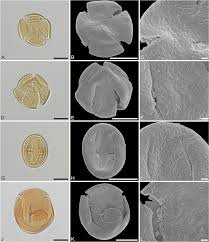
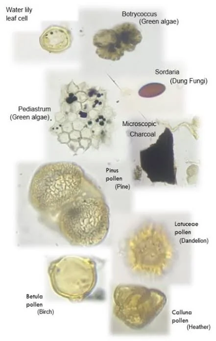
One way to investigate these vanished landscapes is through the analysis of pollen preserved in sediment cores. Pollen grains produced by plants can survive for thousands of years under suitable conditions. Their presence and distribution provide clues about past vegetation, climate, and human land use.

By studying pollen records from coastal cores, researchers can reconstruct submerged Bronze Age environments and investigate how changing shorelines affected communities that lived and worked near the sea.

How Coastal Meadows Became Submerged

Sea levels have changed repeatedly since the end of the last Ice Age. As global temperatures increased and continental ice sheets melted, seawater expanded and flooded low-lying coastal areas.

The timing and rate of this process varied by region. Local factors such as land uplift, subsidence, sediment movement, and tectonic activity also influenced the position of shorelines.

An area that once supported grassland or wet meadow could eventually become a tidal flat, estuary, or shallow seabed.

The transition was not always sudden. In some places, rising water gradually altered drainage patterns and soil conditions. Freshwater vegetation may have been replaced by salt-tolerant plants before the area became permanently submerged.

These environmental transitions can be preserved in sediment layers.

What Are Coastal Sediment Cores?

A sediment core is a cylindrical sample extracted from the ground or seabed. It preserves a vertical sequence of deposits that accumulated over time.

Coastal cores may contain layers of peat, clay, sand, silt, shell fragments, and organic material. Each layer reflects particular environmental conditions.

Peat may indicate wetland or marsh development, while marine microfossils can suggest the presence of seawater. Changes in sediment grain size may reflect shifts in water energy, erosion, or deposition.

The sequence can provide a record of landscape transformation.

However, sediment layers are not always deposited continuously. Storms, erosion, river activity, and human disturbance can remove or mix earlier deposits.

Researchers must therefore examine the core carefully before reconstructing its environmental history.

Understanding Pollen Analysis

Pollen analysis, also known as palynology, examines microscopic pollen grains preserved in sediments.

Plants produce pollen with distinctive shapes and surface structures. Under a microscope, specialists can often identify pollen to a family, genus, or sometimes species level.

Different plants produce pollen at different rates and disperse it over different distances. As a result, pollen percentages do not directly represent the exact abundance of every plant in the surrounding landscape.

Nevertheless, changes in pollen composition can reveal important environmental patterns.

A core containing high proportions of grass pollen may indicate open vegetation, while tree pollen can suggest woodland. The presence of salt-tolerant plants may point toward coastal or saline conditions.

Reconstructing Bronze Age Meadows

A submerged meadow can be identified through a combination of pollen evidence and sediment characteristics.

High proportions of grasses and certain herbaceous plants may indicate open ground. Pollen from wetland species can suggest damp or periodically flooded conditions.

If the core also contains freshwater indicators and organic-rich sediment, researchers may infer the presence of a freshwater meadow or marsh.

The interpretation becomes stronger when pollen evidence is combined with plant macrofossils, insect remains, diatoms, and other environmental indicators.

For example, seeds preserved in sediment may provide more precise evidence of local vegetation than pollen alone. Insect remains can reveal whether the area was wet, dry, freshwater, or brackish.

Evidence of Human Activity

Pollen records can also provide clues about Bronze Age land use.

An increase in pollen from plants associated with disturbed ground may indicate cultivation, grazing, or other human activities. Declines in tree pollen may reflect woodland clearance, although climate change and natural disturbance can produce similar patterns.

Some pollen types are associated with agricultural crops. Cereal pollen can provide evidence for cultivation, although it is not always easy to distinguish different cereal species.

The presence of certain weeds may also suggest farming activity.

Researchers must consider the possibility that pollen arrived from distant areas. A small amount of cereal pollen in a coastal core does not necessarily prove that crops were grown directly beside the sampling location.

Coastal Grazing and Pastoral Economies

Meadows and wetlands could have provided valuable grazing resources.

Livestock might have been moved toward coastal areas during particular seasons, especially where grass remained available during dry periods elsewhere.

Salt marshes and coastal grasslands could support animals adapted to these environments. However, grazing conditions would depend on flooding frequency, soil salinity, and the availability of fresh water.

Evidence for pastoral activity may include dung-related fungal spores, changes in vegetation, animal remains, and archaeological features associated with livestock management.

When several indicators occur together, researchers can investigate whether a submerged meadow was used as pasture during the Bronze Age.

Dating the Sediment Record

A reliable environmental reconstruction depends on accurate chronology.

Radiocarbon dating can be applied to suitable organic material preserved in sediment, such as peat or plant remains.

Researchers may also use other chronological techniques depending on the age and composition of the deposits.

Dating multiple levels within a core helps establish how quickly sediment accumulated and when major environmental changes occurred.

However, old carbon can sometimes be transported into younger deposits. Marine environments may also create dating complications because organisms can incorporate carbon from seawater with a different apparent age.

For this reason, dating results must be calibrated and interpreted in relation to the local geological setting.

Sea-Level Change and Human Settlement

Reconstructing submerged meadows can help archaeologists understand how coastal communities adapted to environmental change.

Rising sea levels may have gradually reduced available land, changed access to freshwater, or transformed familiar grazing areas.

Some communities may have moved settlements inland or toward higher ground. Others could have adapted their economies by shifting toward fishing, maritime trade, or different agricultural practices.

However, coastal change should not automatically be treated as the cause of settlement abandonment. Social conflict, economic shifts, disease, and political developments may also have influenced population movements.

The strongest interpretations combine environmental evidence with archaeological settlement records.

Recovering Submerged Landscapes

Researchers use several methods to locate former coastal environments.

Seabed mapping, sediment coring, geophysical survey, and underwater archaeological investigation can identify buried landforms and deposits.

Sonar systems can reveal submerged channels, terraces, and other features beneath the seabed. Core samples then provide information about the materials and environmental conditions associated with these landforms.

In shallow coastal waters, divers or remotely operated equipment may help document archaeological remains.

The process requires close cooperation between archaeologists, geologists, palaeoecologists, and marine scientists.

Limitations of Pollen Records

Pollen records are powerful but imperfect.

Some plants produce large amounts of pollen that travel long distances, while others are poorly represented. Preservation conditions also vary.

Sediment disturbance can mix pollen from different periods. Erosion may remove older deposits, while redeposition can introduce ancient pollen into younger layers.

For these reasons, pollen should not be interpreted in isolation.

The most reliable reconstructions combine pollen with sedimentology, plant macrofossils, microfossils, geochemical data, and archaeological evidence.

Conclusion

Submerged Bronze Age meadows preserve valuable evidence of coastal environments that disappeared as sea levels and shorelines changed.

Pollen records from sediment cores can help reconstruct the vegetation of these landscapes, identify possible grazing areas, and investigate the relationship between human activity and environmental change.

The study of these deposits demonstrates that archaeological landscapes do not end at the modern shoreline. Some former fields, wetlands, and meadows now lie beneath coastal waters, preserving traces of environments that supported human communities thousands of years ago.

By combining palaeoecology, geology, and archaeology, researchers can recover parts of these vanished landscapes and better understand how Bronze Age societies adapted to the changing boundaries between land and sea.
Pastoral Ritual Sites Along the Mongolian Steppe Corridors

November 8, 2026

Introduction

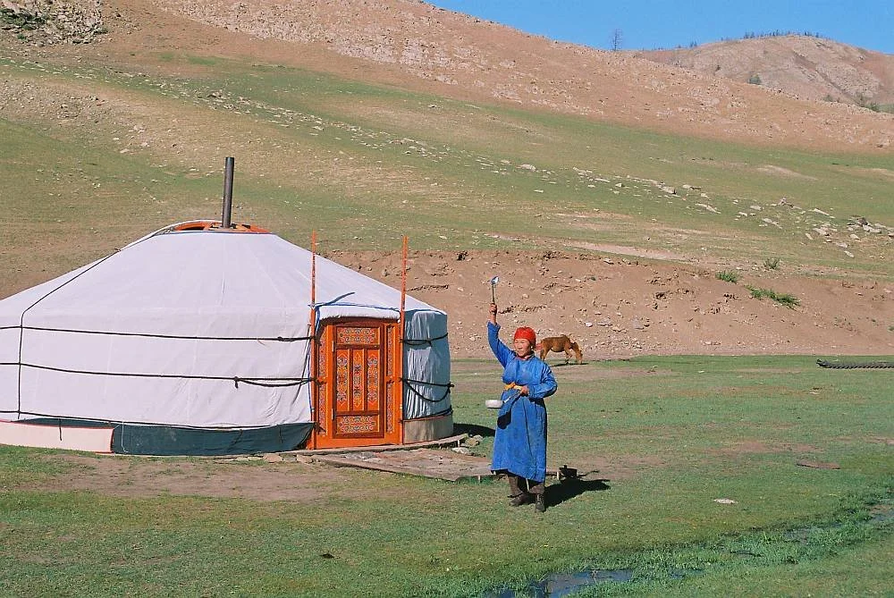
The Mongolian steppe has supported mobile pastoral societies for thousands of years. Its broad grasslands, mountain valleys, and seasonal water sources provided opportunities for raising horses, sheep, goats, cattle, and other livestock.

Mobility was essential to many pastoral economies. Herds needed access to fresh grazing, and families often moved between seasonal camps according to weather, pasture conditions, and water availability.

Along these routes, communities also created places with social, symbolic, and ritual importance. These sites could include stone monuments, burial complexes, ceremonial enclosures, and locations associated with offerings or gatherings.

The archaeology of pastoral ritual sites along Mongolian steppe corridors provides an opportunity to explore how movement, landscape, religion, and social identity were connected in ancient and historic communities.

The Mongolian Steppe as a Cultural Landscape

The Mongolian steppe is not simply an open grassland. It contains a variety of ecological zones, including mountain slopes, river valleys, desert margins, and elevated plateaus.

Pastoral groups adapted their movements to these environments. Some areas provided summer pasture, while others offered better conditions during winter.

Routes between these locations could become important corridors of movement. Over generations, families and communities developed knowledge of water sources, grazing areas, sheltered valleys, and difficult terrain.

These routes also connected settlements, markets, political centers, and ceremonial places.

Pastoral Mobility and Social Organization

Mobile pastoralism requires careful coordination. Herd owners must balance grazing needs, animal health, water access, and the movement of households.

Mobility can also shape social relationships. Families may share grazing areas, exchange animals, arrange marriages, or cooperate in protecting herds.

Seasonal gatherings provide opportunities for trade, ceremonies, dispute resolution, and political negotiation.

Ritual sites located along movement corridors may therefore have served communities beyond the immediate vicinity. They could function as shared places where people gathered during important stages of the pastoral calendar.

Archaeological Forms of Ritual Sites

Mongolia contains a wide range of archaeological monuments associated with ancient communities.

These include deer stones, khirigsuur burial and ceremonial complexes, stone mounds, ritual enclosures, and other monumental features.

Their functions are not always fully understood. Some appear to have been connected with burial practices, memorialization, animal offerings, or ceremonial activities.

The presence of such monuments along routes and in prominent landscapes may indicate that movement through the steppe was associated with cultural and symbolic meanings.

However, not every stone structure was necessarily a ritual site. Some features may have served practical purposes, and interpretations must be based on archaeological context.

Deer Stones and Symbolic Landscapes

Deer stones are among the most recognizable monuments of Bronze Age Mongolia and neighboring regions.

These upright stones often contain carved images of stylized deer and other symbols. Some also include representations of weapons, belts, or other objects.

Their precise meanings remain debated. They are frequently discussed in relation to elite burials, memorial practices, and broader ritual landscapes.

Their placement may have been significant. Some stand near burial mounds or larger ceremonial complexes, while others occupy open landscapes with broad visibility.

These monuments demonstrate that ancient pastoral communities invested considerable effort in creating durable features within environments where everyday settlement structures could be temporary.

Khirigsuur Complexes

Khirigsuurs are large stone structures commonly associated with Bronze Age Mongolia.

They often consist of a central mound surrounded by stone features, sometimes including satellite arrangements or associated deposits.

Researchers have investigated their relationship with burial practices, ceremonial gatherings, and horse-related rituals.

Some complexes contain evidence of animal offerings, particularly horse remains. These deposits suggest that horses had symbolic importance beyond their practical value for transportation and herding.

The scale of some complexes indicates coordinated labor and shared cultural traditions.

Ritual and the Horse

The horse was central to many steppe societies. It supported transportation, herding, warfare, communication, and long-distance exchange.

Its importance also extended into ritual life.

Horse remains found in ceremonial contexts suggest that animals could be incorporated into offerings, memorial practices, or social displays.

Such practices may have expressed status, ancestry, community identity, or relationships between humans and the landscape.

The archaeological interpretation of horse deposits requires attention to context. A group of animal bones might represent a ritual offering, ordinary food consumption, or another activity. Burial position, associated objects, and patterns of butchery help distinguish these possibilities.

Ritual Corridors and Seasonal Movement

A ritual site positioned along a pastoral route may have been visited repeatedly by different groups.

It could serve as a place for ceremonies at particular times of the year, especially when communities gathered to exchange information or coordinate movement.

Some sites may also have been associated with natural landmarks, such as mountain passes, springs, river crossings, or distinctive rock formations.

These features could become important reference points in the cultural geography of mobile communities.

However, proving that a monument functioned as a stopping point along a specific seasonal route requires more than geographic proximity. Researchers must consider archaeological dating, settlement patterns, and evidence for repeated activity.

Archaeological Methods

Researchers investigate pastoral ritual sites through excavation, landscape survey, geophysical analysis, and remote sensing.

Satellite imagery can identify large stone features and relationships between monuments and terrain. Ground surveys help determine whether apparent structures are natural or constructed.

Excavation can reveal the sequence of construction, the presence of offerings, and the relationship between monuments and surrounding activity areas.

Radiocarbon dating of associated organic material may help establish chronology. Animal bone analysis can provide information about species selection, age, diet, and the treatment of animals.

Researchers may also use stable isotope analysis to investigate where animals were raised and whether they moved between different ecological zones.

The Relationship Between Ritual and Political Power

Monumental ritual sites could reinforce social authority.

Organizing the construction of a large stone complex required labor and coordination. Leaders or influential families may have used ceremonies to demonstrate status, maintain alliances, or commemorate important ancestors.

The relationship between ritual and political power was not necessarily centralized. Local communities could organize their own monuments and ceremonies without being controlled by a large state.

Some sites may therefore represent shared traditions rather than direct evidence of centralized political authority.

Changing Landscapes and Cultural Continuity

Pastoral routes and ritual landscapes changed over time.

Climate shifts, political developments, warfare, and changes in livestock economies could alter patterns of movement.

A site that once served as an important gathering place might eventually be abandoned. Its monuments could remain visible even after the communities that created them had moved elsewhere.

Later populations might also reuse older structures or assign new meanings to them.

This creates a complex archaeological record in which different periods of activity may overlap.

Conclusion

Pastoral ritual sites along Mongolian steppe corridors reveal how mobile communities connected movement, ceremony, ancestry, and landscape.

Monuments such as deer stones and khirigsuur complexes demonstrate that pastoral societies were capable of creating enduring ceremonial architecture despite relying heavily on seasonal mobility.

Their locations may reflect the importance of routes, water sources, mountain passes, and gathering places, although the function of each site must be established through archaeological evidence.

These landscapes show that mobility did not prevent communities from developing strong relationships with particular places. Instead, ritual monuments may have helped transform routes of movement into shared cultural spaces, connecting generations of pastoralists across the vast Mongolian steppe.

The Micro-Architecture of Wet-Season Shelters in Southeast Asia

November 8, 2026

Introduction

Southeast Asia contains a remarkable diversity of environments, including tropical rainforests, river valleys, coastal wetlands, highlands, and seasonal grasslands. Communities living in these landscapes developed different forms of architecture to respond to heat, rainfall, flooding, insects, and changing patterns of mobility.

Not all shelters were large or permanent. Many were small structures designed for temporary occupation during particular seasons or activities. These shelters could be used by hunters, fishers, farmers, traders, and people moving between settlements.

The study of their micro-architecture focuses on the small-scale decisions involved in construction: the placement of posts, the angle of roofs, ventilation openings, flooring materials, drainage arrangements, and the use of locally available resources.

Although temporary shelters rarely survive intact, their archaeological traces can provide valuable information about how people adapted architecture to the wet seasons of Southeast Asia.

The Importance of the Wet Season

The wet season has a major influence on life across much of Southeast Asia. Heavy rainfall can transform rivers, flood low-lying areas, soften soils, and make some routes difficult to travel.

These conditions affect where people can live and work. A location suitable during the dry season may become flooded or inaccessible during periods of intense rain.

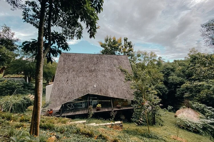
Shelters therefore need to respond to changing environmental conditions. A raised floor can reduce exposure to surface water, while a steep roof helps rainwater run off quickly. Open sides may improve ventilation, although they also increase exposure to wind-driven rain.

Architecture reflects a balance between protection, comfort, mobility, and the resources available to builders.

What Is Micro-Architecture?

Micro-architecture refers to the small-scale structural features of buildings and shelters. Rather than focusing only on overall building plans, researchers examine individual construction elements and how they work together.

For a wet-season shelter, these features might include:

  • closely spaced roof supports,

  • raised sleeping platforms,

  • lightweight wall screens,

  • drainage channels,

  • sloping roofs,

  • ventilation gaps,

  • and replaceable flooring materials.

The term does not imply that these structures were primitive or poorly designed. A small shelter can demonstrate considerable engineering knowledge when its construction is carefully adapted to local conditions.

Raised Platforms and Flood Protection

One of the most recognizable architectural responses to wet environments is the raised platform.

Lifting a shelter above ground level can reduce exposure to surface flooding, mud, and crawling insects. It may also improve air circulation beneath the structure.

The height of the platform depends on local conditions. In areas with seasonal flooding, builders may raise floors significantly. In less flood-prone environments, a modest elevation may be sufficient.

Archaeological evidence for raised platforms can be difficult to identify. Wooden posts may decay, leaving only postholes or stains in the soil. In some environments, repeated flooding can disturb these traces.

Researchers therefore examine posthole arrangements, floor deposits, and surrounding drainage features to reconstruct the likely structure.

Roof Design and Rainwater Management

Roof construction is particularly important in regions that experience intense rainfall.

Steeply pitched roofs allow water to drain quickly and reduce the time that moisture remains on the roofing material. Wide eaves can protect walls and entrances from direct rainfall.

The choice of roofing material depends on local resources. Palm leaves, grasses, bark, bamboo, and other plant materials can be used in different combinations.

A roof may also be designed for easy replacement. Organic materials deteriorate in humid environments, so a shelter intended for repeated seasonal use may require regular repairs.

Archaeological remains rarely preserve the original roof. However, post spacing, roof-support arrangements, and impressions in clay may provide clues about construction techniques.

Ventilation and Thermal Comfort

Tropical humidity makes ventilation important. A shelter that traps warm, moist air can become uncomfortable and encourage mold growth.

Open-sided structures, raised floors, and gaps between wall materials can improve airflow. Some shelters may use screens or partial walls to provide protection while maintaining ventilation.

The orientation of a building can also matter. Builders may position openings to capture prevailing breezes or reduce exposure to strong winds.

These choices are difficult to reconstruct from archaeological evidence alone. Nevertheless, post arrangements and surviving architectural traditions can provide comparative information.

Materials and Construction Techniques

Southeast Asian communities had access to a wide range of building materials.

Bamboo is lightweight and versatile. It can be used for posts, frames, floors, walls, and roof supports. Palm leaves and grasses provide roofing materials, while timber may be used for more durable structural components.

The selection of materials often reflects the expected lifespan of the shelter. A temporary structure may rely heavily on materials that are easy to collect and replace.

More permanent buildings may require stronger foundations and more elaborate joinery.

Builders could also combine materials. A wooden framework might support woven plant walls, while a raised floor could be constructed from split bamboo or timber planks.

Seasonal Mobility

Wet-season shelters may have been associated with seasonal movement between different resource zones.

For example, communities could move toward elevated ground during periods of flooding or establish temporary shelters near seasonal fishing areas.

Farmers might also use small structures near fields to store tools, protect harvested crops, or provide temporary accommodation during agricultural work.

Not every seasonal shelter indicates nomadic life. People living in permanent villages may still construct temporary buildings for particular tasks.

The distinction between permanent settlement and temporary occupation is therefore important.

Archaeological Evidence

The remains of temporary shelters are often subtle. Postholes, hearths, compacted surfaces, drainage cuts, and concentrations of domestic artifacts can indicate occupation.

Organic materials may survive only in unusually favorable conditions, such as waterlogged deposits or environments with limited oxygen.

Archaeologists can examine soil chemistry to identify areas where human activity occurred. Phosphate concentrations, charcoal, burned clay, and microscopic plant remains may reveal the location of floors, cooking areas, and waste deposits.

The spatial arrangement of these features can help distinguish a shelter from an open-air activity area.

Ethnographic Comparisons

Modern and historically documented building traditions can help researchers understand the possible function of ancient structures.

Traditional stilt houses, bamboo shelters, raised granaries, and seasonal field huts provide examples of how builders respond to similar environmental challenges.

However, ethnographic comparison must be used carefully. A modern structure cannot automatically be treated as an unchanged survival of prehistoric architecture.

Communities adapt their construction methods over time, and the same environmental problem can produce different architectural solutions.

Preservation Challenges

The tropical climate creates serious difficulties for archaeological preservation.

Wood, leaves, bamboo, and other organic materials can decay quickly. Heavy rainfall may erode occupation surfaces, while floods can transport artifacts away from their original locations.

Later construction may also destroy earlier postholes and floors.

These conditions mean that the archaeological record may underestimate the importance of temporary architecture. A community could have relied extensively on lightweight shelters without leaving substantial visible remains.

Conclusion

The micro-architecture of wet-season shelters in Southeast Asia reveals how communities responded to rainfall, flooding, humidity, and seasonal mobility through carefully adapted construction.

Raised platforms, steep roofs, open ventilation, drainage features, and lightweight materials were not arbitrary design choices. They represented practical solutions to environmental conditions that shaped daily life.

Although temporary shelters are difficult to reconstruct archaeologically, postholes, soil deposits, hearths, and preserved organic materials can provide important evidence.

Studying these small structures expands our understanding of architecture beyond monumental buildings. It highlights the ingenuity involved in everyday construction and demonstrates how even temporary shelters can preserve valuable information about technology, mobility, and human adaptation.

Rock Art Calendars of the Central Sahara

November 8, 2026

Introduction

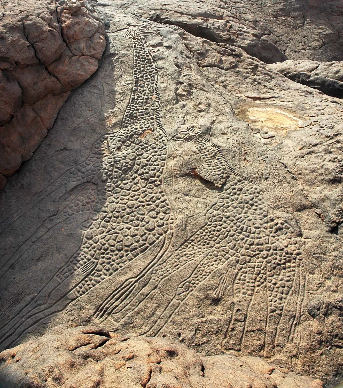
The Central Sahara contains some of the most remarkable collections of prehistoric rock art in the world. Across its mountains, plateaus, and desert valleys, ancient artists created images of animals, people, hunting activities, ceremonies, and everyday life.

These images are valuable historical sources because they preserve information about environments and communities that existed thousands of years ago. Some researchers have also investigated whether particular rock art panels could have functioned as calendars, recording seasonal changes, astronomical observations, or important events in the annual cycle.

The idea of a rock art calendar is intriguing, but it requires careful interpretation. A painting or engraving showing animals, celestial objects, or repeated symbols does not automatically represent a formal calendar. Archaeologists must examine the arrangement, chronology, cultural context, and possible relationship between the images and seasonal environmental changes.

The Central Sahara in Prehistory

The Sahara was not always the hyper-arid desert familiar today. During wetter periods, parts of the region contained lakes, rivers, grasslands, and vegetation capable of supporting substantial human and animal populations.

These environmental changes influenced settlement, mobility, and economic activities. Communities could hunt wild animals, raise livestock, gather plants, and move between water sources.

As the climate became increasingly dry, populations adapted their activities and settlement patterns. Some groups moved toward more reliable water sources, while others developed pastoral strategies suited to changing conditions.

Rock art preserves traces of these transformations. Images of large wild animals, cattle, and other species provide clues about the environments in which ancient artists lived.

What Is a Rock Art Calendar?

A calendar organizes time through recurring cycles. These may include the movement of the sun, the phases of the moon, the appearance of particular stars, rainfall patterns, or seasonal changes in plants and animals.

A rock art calendar would therefore be a visual system through which people recorded or communicated recurring temporal information.

Such a system might contain repeated symbols, sequences of images, or representations associated with predictable environmental events. However, a calendar does not need to resemble a modern written system.

In societies where knowledge was transmitted orally, images could support shared memories and seasonal teaching. A particular animal might signal a migration period, while a recurring natural event could indicate when to move livestock or collect certain resources.

Animals as Seasonal Indicators

Animal imagery is particularly important in Saharan rock art. Different species require specific environmental conditions and may appear in particular landscapes or seasons.

The presence of cattle, wild fauna, and other animals can provide evidence for the ecological conditions represented by a particular artistic tradition.

However, the relationship between an animal image and a season must be established carefully. An animal may be depicted because it held religious significance, represented social status, or formed part of a narrative rather than because it indicated a particular time of year.

Comparing the images with archaeological evidence, faunal remains, and palaeoenvironmental records can help clarify their possible meanings.

Astronomical Interpretations

Some researchers have explored whether prehistoric rock art reflects observations of the sun, moon, stars, or other celestial phenomena.

Astronomical knowledge could have been useful for organizing seasonal activities. The changing position of the sun, for example, provides a predictable reference for the annual cycle.

A panel containing repeated marks or carefully positioned figures might invite astronomical interpretation. Yet such interpretations are vulnerable to speculation when the symbols are not clearly understood.

A convincing astronomical explanation requires more than a visual resemblance. Researchers need to demonstrate that the arrangement is intentional, that the proposed celestial relationship is plausible for the period, and that the interpretation fits the wider cultural context.

Rock Art and Pastoral Calendars

The development of pastoralism created new demands for seasonal planning. Herd owners needed to understand the availability of water, pasture, and safe routes.

In arid environments, the timing of movement could be especially important. A community might travel toward a seasonal grazing area after rainfall and return when resources became scarce.

Rock art could have helped communicate information about animals, landscapes, and important locations. It may also have supported collective memory by recording routes, encounters, and culturally significant events.

However, the existence of pastoral calendars does not prove that specific rock art panels were used as calendar charts. This remains a question requiring site-specific investigation.

Dating Rock Art

Establishing the age of rock art is essential for understanding its possible function. Direct dating is difficult because pigments and engraved surfaces may not contain materials suitable for standard dating methods.

Researchers may use several approaches, including radiocarbon dating of associated organic pigments where suitable, dating of mineral deposits that formed over or beneath an image, and comparison with archaeological layers.

Stylistic analysis can also provide chronological clues. Changes in the representation of animals, clothing, weapons, and human figures may help identify different artistic traditions.

Nevertheless, stylistic sequences are not always precise. A motif may remain in use for a long period, and artists may deliberately reproduce older styles.

The Importance of Landscape Context

Rock art should not be studied as an isolated collection of images. Its location may be meaningful.

A panel overlooking a valley, water source, migration corridor, or mountain pass could have served a different purpose from one located inside a sheltered cave.

Researchers examine visibility, accessibility, nearby archaeological sites, and relationships with natural features.

Some locations may have functioned as gathering places. Others may have been connected with ritual activities, territorial claims, or communication between communities.

A possible calendar interpretation becomes stronger when the images are associated with environmental features relevant to seasonal planning.

The Limits of Interpretation

One of the greatest challenges in rock art research is the absence of direct testimony from the artists. Images can preserve cultural information, but their meanings may not be recoverable with certainty.

A repeated pattern might represent counting, decoration, ownership, ritual symbolism, or something that modern researchers have not considered.

The same image could also have served different purposes at different times.

For this reason, researchers should distinguish between observable evidence and interpretation. A panel may clearly depict animals and human figures, while its supposed function as a seasonal calendar remains hypothetical.

Modern Research Methods

Digital photography, photogrammetry, three-dimensional scanning, and geographic information systems have expanded the study of Saharan rock art.

High-resolution imaging can reveal faint engravings and pigment traces that are difficult to see in ordinary light. Three-dimensional models allow researchers to examine the depth and technique of engravings.

Geographic information systems can compare the location of rock art panels with water sources, terrain, archaeological settlements, and reconstructed environmental conditions.

These methods make it possible to investigate patterns across large regions rather than relying only on individual panels.

Conclusion

Rock art calendars of the Central Sahara offer a fascinating possibility for understanding how prehistoric communities observed and organized time. Images of animals, people, and environmental features may preserve knowledge about seasonal movement, pastoral activities, and recurring natural events.

However, identifying a particular panel as a calendar requires strong evidence. Astronomical alignments, animal sequences, and repeated symbols must be evaluated within their archaeological and environmental contexts.

The greatest value of this research lies in examining how ancient communities understood their changing surroundings. Even when the precise meaning of a rock art panel remains uncertain, it can reveal how people used images to preserve memory, communicate knowledge, and maintain relationships with the landscapes on which their survival depended.

Small-Scale Smelting Camps on Highland Ridges

November 8, 2026

Introduction

The history of ancient metallurgy is often associated with major mining districts, permanent industrial settlements, and large furnaces. However, metal production did not always take place in centralized workshops. In many regions, small groups of metalworkers established temporary smelting camps near mineral deposits, woodland resources, and suitable sources of water.

Highland ridges could provide several advantages for these activities. They offered access to exposed mineral deposits, favorable locations for controlling furnace temperatures, and proximity to forests that supplied fuel. Some camps may have operated seasonally, allowing workers to exploit resources without maintaining permanent settlements.

The archaeology of these small-scale smelting sites provides an opportunity to investigate how technological knowledge spread beyond major centers of production. It also reveals the relationship between metallurgy, seasonal mobility, landscape use, and local economies.

Why Highland Ridges Were Selected

The location of a smelting camp depended on several practical considerations. Ore availability was important, but it was not the only factor. Metalworkers also needed fuel, water, suitable construction materials, and access to routes through which finished products could be transported.

Highland ridges sometimes exposed mineral-bearing rocks through natural erosion. This could make certain ores easier to locate than deposits hidden beneath deep soil. Workers could identify promising materials through their color, weight, texture, and other visible characteristics.

Elevated locations could also offer access to prevailing winds, although furnace design and airflow requirements varied considerably. Some smelting installations were constructed to take advantage of natural air movement, while others relied on bellows or carefully designed openings.

The selection of a site therefore reflected a combination of geological opportunity and technological experience.

The Structure of Temporary Smelting Camps

A small smelting camp might contain several features arranged around a working area. These could include furnace remains, roasting pits, charcoal deposits, ore-crushing surfaces, storage spaces, and temporary shelters.

Not every camp would contain all these features. Some stages of metal production might have taken place at a nearby location, while other activities were performed directly beside the furnace.

Furnaces could be constructed from clay, stone, or combinations of both. Their size and design depended on the type of ore, the desired metal, available materials, and local metallurgical traditions.

Temporary shelters may have been relatively simple. Workers could use wooden frameworks, lightweight roofing materials, or natural rock formations for protection. Because such structures were often made from perishable materials, they may leave little archaeological evidence.

The Smelting Process

Smelting involves extracting metal from ore through heating and chemical reactions. The precise process varies depending on the metal being produced and the mineral composition of the ore.

For copper production, for example, suitable copper ores were heated under controlled conditions to separate metal from unwanted components. Iron production required different temperatures and chemical conditions, often producing a spongy mass known as a bloom rather than immediately yielding liquid iron.

Fuel was essential. Charcoal was particularly valuable because it could produce high temperatures and create a reducing environment inside the furnace.

The process required considerable practical knowledge. Metalworkers had to understand how to prepare ore, regulate airflow, maintain furnace temperatures, and recognize when the material was ready for further processing.

Evidence Left Behind

Smelting camps can be identified through several types of archaeological evidence. Furnace fragments, slag, tuyères, charcoal, and ore-processing remains are particularly important.

Slag is one of the most useful indicators. It is the waste material produced during smelting and often preserves chemical information about the process. Its composition can help researchers identify the type of ore and the metallurgical techniques used.

Tuyères, or air-delivery pipes, may provide evidence for how oxygen entered the furnace. Their shape and heat damage can help reconstruct furnace operation.

Researchers may also examine microscopic residues and metallurgical inclusions. These can reveal production techniques that are not visible from the overall shape of the remains.

Seasonal Mobility and Labor

Small smelting camps may have been occupied only during particular periods of the year. Workers could travel to highland areas when weather conditions allowed access to ore deposits and fuel supplies.

Seasonal operation may have been connected to agricultural calendars. Communities could organize metal production during periods when fewer people were required for planting or harvesting.

However, not every small smelting site was temporary. Some may have operated repeatedly over generations, gradually accumulating substantial archaeological deposits.

The organization of labor is equally important. A small team could handle ore preparation, furnace construction, fuel collection, and smelting. More demanding operations might require cooperation between specialists and local communities.

Metallurgy and Local Exchange

Metal produced in highland camps could supply nearby settlements or enter wider exchange networks. Finished objects might include tools, weapons, ornaments, and components used in agricultural or domestic activities.

In some cases, workers may have transported metal in semi-processed forms to larger workshops. This would allow specialized craftsmen elsewhere to produce finished objects without operating their own furnaces.

The movement of metal can be investigated through chemical and isotopic analysis, although determining the exact geological source is not always straightforward. Metals could be mixed, recycled, or transported through several intermediate communities.

Environmental Impact

Smelting required considerable fuel, especially where production was repeated over long periods. Charcoal production could place pressure on nearby woodland.

Archaeologists can investigate this impact through charcoal analysis, pollen records, and changes in vegetation. A decline in certain tree species near a production area may indicate intensive fuel collection, although climate and other land-use activities must also be considered.

Mining and ore processing could alter slopes, expose soils, and create waste deposits. These changes sometimes remain visible long after production ended.

Identifying a Smelting Camp

A concentration of slag alone does not always prove that smelting occurred at the location. Waste material could have been transported from another site or reused in later construction.

Researchers therefore look for combinations of evidence. Furnace remains, slag deposits, ore fragments, fuel residues, and related working surfaces provide a stronger basis for interpretation.

Dating is also important. Charcoal from a furnace may be radiocarbon dated, provided its archaeological context is secure. Researchers must consider the possibility that older wood was used as fuel, which can make a date appear earlier than the actual smelting event.

Conclusion

Small-scale smelting camps on highland ridges demonstrate that ancient metallurgy was not limited to major industrial centers. Metal production could take place in temporary or semi-permanent locations where workers combined geological knowledge, fuel resources, and specialized technical skills.

These sites reveal the mobility of metalworkers and the relationship between local environments and technological production. Their remains also provide valuable evidence for the organization of labor, resource management, and exchange.

Although many smelting camps are difficult to identify because their structures were temporary, the surviving slag, furnace fragments, and environmental evidence can help reconstruct activities that once connected remote highland landscapes with wider economic networks.

Invisible Field Boundaries: Detecting Ancient Hedgerows with LiDAR

October 28, 2026

Introduction

Ancient agricultural landscapes often preserve evidence of human activity long after the original fields, settlements, and farming systems have disappeared. Among the most subtle features are historic field boundaries, including hedgerows, earthen banks, shallow ditches, and rows of trees that once divided agricultural land into manageable units.

These boundaries can be difficult to recognize from the ground. Centuries of plowing, woodland growth, urban development, and natural erosion may conceal their original form. However, advances in remote sensing have created new opportunities to investigate them. One particularly valuable technology is Light Detection and Ranging (LiDAR), which can reveal subtle changes in ground elevation even beneath dense vegetation.

By combining LiDAR data with archaeological surveys, historical maps, and environmental evidence, researchers can reconstruct former agricultural landscapes and investigate how communities organized land ownership, farming, and settlement.

Understanding Ancient Field Boundaries

Field boundaries served several practical purposes in ancient and historical societies. They separated cultivated plots, controlled livestock, marked property divisions, and helped communities manage access to shared resources. Their construction depended on local environmental conditions and available materials.

In wooded regions, hedgerows could consist of closely planted shrubs and trees. In areas with limited vegetation, farmers might construct earthen banks or stone walls. Ditches could help drain wet fields while simultaneously marking boundaries. Some boundaries combined several features, such as a ditch beside a raised bank planted with trees.

These structures were not always permanent. A boundary could be abandoned when land ownership changed, a settlement declined, or agricultural practices shifted. Over time, vegetation might grow over the remains, transforming a functional division into a subtle ridge or depression.

Although field boundaries may appear insignificant compared with castles or temples, they can reveal the organization of everyday life. Their arrangement can indicate whether land was divided into small family plots, larger agricultural estates, communal grazing areas, or specialized production zones.

How LiDAR Works

LiDAR systems measure distances by emitting laser pulses and recording the time required for reflected signals to return to a sensor. When mounted on an aircraft, the system can collect millions of measurements across a large landscape.

Some laser pulses strike tree canopies, while others pass through gaps in the vegetation and reach the ground. By processing these measurements, researchers can create a digital representation of the terrain beneath the vegetation.

This capability is particularly important in areas where conventional aerial photography cannot clearly show archaeological features. A woodland that appears visually uniform from above may contain former field systems, abandoned roads, settlement platforms, and drainage channels.

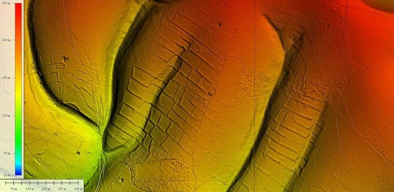
Researchers can use digital elevation models to create shaded-relief images, slope maps, and other visualizations that emphasize small differences in ground height. These products may reveal long, narrow ridges or depressions consistent with former agricultural boundaries.

However, LiDAR does not automatically identify archaeological features. Natural processes can produce similar landforms, and modern forestry or drainage may create misleading patterns. Interpretation requires comparison with other evidence.

Recognizing Hedgerows in the Landscape

Historic hedgerows can survive in several forms. Some remain as living lines of shrubs and trees, while others persist as raised banks, shallow ditches, or strips of woodland separating former fields.

In LiDAR-derived terrain models, a former boundary may appear as a narrow linear elevation change. A bank may produce a raised feature, while an accompanying ditch appears as a depression. Repeated parallel lines can indicate a larger field system.

The arrangement of these features matters as much as their individual appearance. A network of connected boundaries may form rectangular fields, irregular enclosures, or long strips aligned with a valley. Such patterns can reveal how agricultural land was divided and adapted to local terrain.

Researchers must also distinguish ancient boundaries from more recent ones. Modern property divisions, drainage works, forestry tracks, and military earthworks can resemble older agricultural features. Historical maps, aerial photographs, and field observations help establish their likely date and function.

Combining LiDAR with Historical Maps

Historical maps provide an important comparison for archaeological landscape analysis. Estate maps, cadastral surveys, tithe maps, and early topographic maps may record boundaries that existed several centuries ago.

When these maps are georeferenced and compared with LiDAR imagery, researchers can identify features that survived after their removal from official maps. A boundary visible in an eighteenth-century estate map but absent from a later survey may still appear as a subtle bank in the terrain.

The reverse situation is also informative. A linear feature identified in LiDAR but absent from surviving maps may predate the earliest available documentation. However, absence from a map does not prove great antiquity. Cartographers may simply have omitted minor boundaries.

Map comparisons also help reconstruct changes in land use. A landscape once divided into many small plots might later have been consolidated into larger farms. The physical remains of earlier boundaries can reveal the extent of that transformation.

Dating Ancient Agricultural Boundaries

Determining the age of a field boundary can be challenging. Its shape alone rarely provides a precise date.

Archaeologists may investigate the soils beneath an earthen bank, examine artifacts incorporated into its construction, or excavate sections where a boundary intersects another feature. If the boundary overlies an older archaeological deposit, it must postdate that deposit. If another structure cuts through it, the boundary is earlier than the later feature.

Environmental evidence can also help. Pollen, seeds, charcoal, and other biological remains may provide information about the vegetation and land use associated with the boundary. Radiocarbon dating may be possible when suitable organic material is recovered from a secure archaeological context.

Researchers should avoid treating the age of a nearby tree or hedgerow as the age of the entire boundary. A modern tree may have grown on an earthwork that is hundreds or even thousands of years old.

What Field Boundaries Reveal About Society

The arrangement of field systems can provide insights into social organization. Small, irregular plots may reflect long-term subdivision among families, adaptation to uneven terrain, or the gradual accumulation of property rights.

Large, regularly planned fields may indicate coordinated land division, estate management, or agricultural reorganization. Yet geometric regularity alone cannot prove centralized control. Similar layouts can emerge from practical responses to terrain or local farming requirements.

Boundaries may also reveal relationships between cultivation and livestock management. Banks and hedges could restrict animal movement, while gaps and gates controlled access to particular fields. Ditches might separate cultivated areas from wetter ground or provide drainage.

When mapped across an entire region, these features can show how communities balanced arable farming, pasture, woodland, and access routes. They may also identify abandoned land that later returned to forest or grassland.

Environmental Change and Landscape Preservation

Ancient boundaries are shaped by environmental processes. Erosion may reduce raised banks, while sediment accumulation can fill ditches. Tree roots can disturb the original structure, and modern agricultural machinery may flatten low earthworks.

In some regions, woodland has protected old field systems from intensive plowing. In others, forests conceal features that remain visible in the terrain but are difficult to recognize from ground level.

LiDAR is therefore particularly valuable for documenting landscapes before new development, forestry operations, or infrastructure projects alter them. Digital models provide a record that can be revisited as new archaeological questions emerge.

Nevertheless, remote sensing should not be treated as a substitute for conservation. Identifying a feature digitally does not protect it from physical destruction. Archaeological interpretation and land management must work together.

Limitations of LiDAR Research

LiDAR coverage is not equally detailed everywhere. The quality of the results depends on factors such as point density, terrain, vegetation, survey conditions, and data-processing methods.

Very shallow features may remain invisible in low-resolution datasets. Conversely, image-processing techniques can exaggerate minor variations and create patterns that appear more significant than they are.

Researchers should therefore combine several visualization methods and inspect promising features in the field whenever possible. Ground surveys, limited excavation, historical documentation, and environmental sampling help determine whether a suspected boundary is genuinely archaeological.

It is also important to recognize that not every linear earthwork represents a hedgerow. Ancient roads, military boundaries, drainage channels, and natural geological formations can produce similar shapes.

Conclusion

Invisible field boundaries provide an important record of agricultural history. Although they rarely attract the attention given to monumental architecture, they can reveal how people divided land, managed livestock, organized property, and adapted farming to changing environmental conditions.

LiDAR has expanded the possibilities for discovering these features, particularly in wooded landscapes where conventional surveys struggle to identify subtle earthworks. When combined with historical maps, archaeological investigation, and environmental analysis, it can help reconstruct agricultural systems that disappeared from everyday use centuries ago.

The most valuable discoveries often emerge from the relationships between features rather than from a single ridge or ditch. A connected network of boundaries can reveal the structure of a vanished landscape and provide evidence for the everyday decisions through which generations of farmers transformed their surroundings.

Paleo-lakeside Cemeteries: Burials at Vanished Shorelines

October 28, 2026

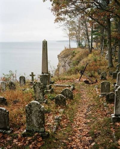
Lakeshores have attracted human communities for thousands of years because they provide access to freshwater, fish, plants, animals, and transportation routes. In prehistoric and historic periods, lakes could also become important places for burial and ritual activity. As water levels changed, former shorelines were abandoned, buried beneath sediment, or submerged, leaving cemeteries in locations that may appear far removed from the present lake edge. The archaeology of paleo-lakeside cemeteries investigates how ancient communities used these changing environments and how burial practices were connected to settlement, landscape, and memory. Identifying such cemeteries requires careful reconstruction of past shorelines as well as reliable archaeological evidence for human burial.

Lakes are dynamic systems. Their water levels respond to precipitation, evaporation, river inflow, groundwater, climate change, and changes in the surrounding drainage basin. Some lakes expand during wetter periods and contract during droughts, while others are affected by glacial processes, tectonic activity, or changes in outlet channels. These fluctuations can shift the boundary between land and water over relatively short periods. A cemetery that once stood near a shoreline may therefore lie inland today, while a burial area once located on dry ground may now be submerged.

Reconstructing an ancient shoreline begins with geological and environmental evidence. Sediment cores can reveal changes from terrestrial soils to lake deposits, or from deep-water sediments to shallow-water environments. Pollen, diatoms, plant remains, and other microfossils can help researchers identify changes in vegetation and water conditions. These records may indicate when a shoreline moved across a particular area. However, environmental evidence alone does not establish that a cemetery existed there. Archaeological survey and excavation are needed to identify graves and determine whether they belong to the period when the reconstructed shoreline was present.

Burials near lakes may take many forms. Some communities buried their dead in organized cemeteries, while others used isolated graves, family burial areas, or locations associated with settlements and ritual sites. Grave construction could include simple pits, stone-lined chambers, wooden containers, or more elaborate monuments. The treatment of the body, orientation of the grave, associated objects, and relationship between individual burials may provide clues about funerary customs. Nevertheless, burial practices vary widely across cultures and periods, and researchers should avoid assuming that every lakeside cemetery served the same social or ritual function.

The position of a cemetery relative to a former shoreline can help illuminate its role in the landscape. A burial area may have been placed near a settlement, on a prominent rise overlooking the water, or at a boundary between cultivated land and wetlands. Such locations could have practical significance, symbolic importance, or both. Water may have formed part of the community's understanding of the transition between life and death, but this interpretation cannot be assumed solely from proximity to a lake. Evidence from grave goods, monuments, settlement patterns, and local traditions is needed to develop a more convincing explanation.

Human remains can contribute information about the people buried at a paleo-lakeside cemetery. Osteological analysis may reveal age at death, biological sex estimates where possible, patterns of injury, and evidence of some diseases or physical stresses. Isotopic analysis of teeth and bones can sometimes provide information about diet and mobility. These findings may help researchers investigate whether the cemetery served a local community or included people who moved into the region. However, skeletal evidence cannot directly establish an individual's ethnic identity, beliefs, or social status without supporting archaeological and historical context.

Grave goods and burial arrangements may reveal social distinctions within a community. Some graves may contain ornaments, tools, weapons, vessels, or other objects, while others contain few or no artifacts. Differences could reflect age, gender roles, occupation, ritual practice, family tradition, or status. Yet the absence of grave goods does not necessarily indicate poverty, and the presence of valuable objects does not automatically prove high political rank. Researchers must consider how objects were selected for burial and whether the cemetery changed over time.

Submerged cemeteries present particular challenges. Water movement can erode graves, displace bones, and redistribute objects. Sediment may conceal burial features, while changing oxygen conditions can affect the preservation of human remains and organic materials. Underwater survey can identify possible grave outlines or concentrations of artifacts, but disturbance may make it difficult to determine whether objects remain in their original positions. In some cases, the best evidence may come from shoreline excavations carried out before inundation or from deposits preserved beneath later sediment.

Dating is essential for connecting a cemetery to a vanished shoreline. Radiocarbon dating of suitable human bone or associated organic materials can provide chronological estimates, but samples must be carefully selected and interpreted. Aquatic food consumption can sometimes affect radiocarbon results because of reservoir effects, in which carbon from older aquatic sources influences the apparent age of human remains. Researchers may need to compare dates from different materials and consider local environmental conditions. Stratigraphic relationships and associated artifacts can provide additional chronological evidence.

The relationship between cemeteries and settlement patterns can reveal how communities responded to environmental change. If a cemetery was established near a lake and later became separated from the water, the change may reflect shoreline movement rather than deliberate relocation. In other cases, declining water levels or changing resources may have influenced settlement decisions. Researchers can compare cemetery chronology with evidence for nearby houses, agricultural fields, fishing installations, and paths to understand whether burial activity continued as the landscape changed.

Paleo-lakeside cemeteries demonstrate how environmental reconstruction can transform the interpretation of archaeological sites. A burial ground that now appears isolated may once have occupied a prominent position beside a lake used for daily subsistence, transportation, and ritual activity. By combining geological evidence, shoreline modeling, burial archaeology, osteological analysis, and scientific dating, researchers can investigate the changing relationship between communities and water. These studies recover not only the physical geography of vanished shorelines but also the ways people placed their dead within landscapes that changed across generations.

Submerged Neolithic Causeways in the English Channel

October 28, 2026

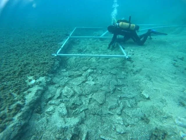
The English Channel contains a complex underwater landscape that has changed dramatically since the end of the last Ice Age. During periods when sea levels were lower, areas now covered by water formed part of a broader landscape connecting what are today southern Britain and northern continental Europe. Rivers crossed low-lying plains, animals moved across open terrain, and human communities occupied places that later became submerged. The possibility of Neolithic causeways beneath the Channel raises important questions about prehistoric mobility, settlement, and the relationship between people and changing coastlines. However, submerged stone alignments or linear features cannot automatically be identified as causeways, and claims of specific Neolithic structures require reliable archaeological evidence.

The landscape of the English Channel was profoundly affected by postglacial sea-level rise. As ice sheets melted, seawater flooded low-lying areas and gradually transformed the geography of northwestern Europe. The timing and pace of inundation varied across different locations, influenced by global sea-level change, regional land movements, erosion, and the shape of the seabed. During the Neolithic, communities occupied landscapes that included coastlines, river valleys, wetlands, and islands whose boundaries differed from those of the modern world. Reconstructing these landscapes is essential for understanding where prehistoric people could have traveled and which areas may now lie underwater.

A causeway is a constructed or deliberately prepared route that allows people to cross wet or difficult terrain. In prehistoric environments, causeways could have consisted of timber, stone, compacted earth, or combinations of materials. Some may have crossed marshes or shallow waterways, while others connected settlements with islands, ritual locations, or resource-gathering areas. A structure described as a causeway must be distinguished from natural gravel ridges, geological formations, submerged river channels, and later maritime installations. Establishing its function requires evidence of deliberate construction, an appropriate date, and a plausible relationship with human movement.

Underwater archaeological survey is the first step in locating possible submerged causeways. Multibeam bathymetry can map the shape of the seabed, while side-scan sonar can identify linear features and differences in surface texture. Sub-bottom profiling may reveal buried structures beneath layers of sediment. These methods can help researchers locate areas that deserve closer investigation, but they cannot always distinguish archaeological remains from natural features. Direct examination by divers or remotely operated vehicles may be necessary to document construction details, although visibility, depth, currents, and sediment disturbance can make underwater work difficult.

Sediment cores can help reconstruct the environment surrounding a possible causeway. Researchers may identify peat, freshwater deposits, marine sediment, or other layers that indicate changing environmental conditions. Organic remains within secure geological contexts can sometimes be radiocarbon dated, providing information about when an area was dry land, wetland, or submerged. Such dates do not automatically establish when a causeway was built, but they can define the period during which a structure could have been used. The relationship between archaeological features and surrounding sediment is therefore crucial.

Timber would be particularly valuable if preserved in a submerged causeway. Wood can survive for long periods in waterlogged environments when oxygen levels are low, although preservation varies with sediment chemistry, water movement, and exposure. Dendrochronology may provide precise dates when sufficient tree rings and suitable reference chronologies are available. Radiocarbon dating can be used where tree-ring dating is not possible, but it generally offers a less precise estimate. Researchers must also determine whether the wood was used in the original structure or introduced by later natural processes.

Stone-built causeways present different challenges. Stones can remain visible after other construction materials have disappeared, but they are also vulnerable to movement by currents, storms, and human activity. A regular arrangement of stones may suggest deliberate construction, yet natural processes can produce surprisingly linear features. Archaeologists should examine the size and selection of the stones, their placement, the presence of a prepared foundation, and their relationship to surrounding deposits. Evidence of repeated maintenance or associated artifacts may strengthen the interpretation of a feature as a constructed route.

The Neolithic context is particularly important because the period witnessed major changes in settlement, farming, material culture, and social organization across Britain and continental Europe. Communities cultivated crops, managed animals, built monuments, and participated in exchange networks, although practices varied by region and time. A causeway could have supported movement between settlement areas, access to wetlands, or travel to resource-rich locations. It might also have served a ceremonial or symbolic purpose. These possibilities should not be treated as mutually exclusive, but researchers need evidence before assigning a specific role to a submerged structure.

The English Channel should not be imagined as a single land bridge that remained intact throughout the Neolithic. The inundation of the region occurred over an extended period, and the geography of waterways and islands changed as sea levels rose. People could have traveled between Britain and continental Europe during periods when suitable routes existed, but the feasibility of a particular journey depended on the precise landscape at the time. Reconstructing these routes requires models of paleogeography supported by geological and archaeological data rather than assumptions based on the modern map.

If submerged Neolithic causeways are identified, they could reveal how communities engineered routes through wetlands and coastal environments. They might also provide evidence of the social importance of particular crossings and the ways people adapted to changing landscapes. Even without a confirmed causeway, the study of submerged prehistoric terrain remains valuable because it restores landscapes that have largely disappeared from view. Underwater archaeology, sediment analysis, scientific dating, and paleogeographic reconstruction together offer a way to investigate how Neolithic communities moved through a world whose coastlines were very different from those seen today.

The Archaeology of Nightwatch Posts: Small Guard Stations and Social Order

October 28, 2026

Nightwatch posts were small installations used to observe movement, protect property, monitor entrances, and provide warning when danger approached. In ancient and historical communities, the need to maintain security did not disappear when daylight ended. Settlements, roads, harbors, agricultural areas, and administrative centers could require observation after dark, particularly where theft, conflict, or unauthorized movement was a concern. Archaeologically identifying a nightwatch post is challenging because such installations may have consisted of simple shelters, raised platforms, small rooms, or reused buildings rather than substantial fortifications. Their significance lies in what they can reveal about the organization of security and the maintenance of social order.

The design of a guard station depended on the environment it monitored. A post near a settlement entrance might provide a view of people approaching along a road, while a station overlooking a harbor could allow observers to monitor vessels and waterfront activity. Posts situated on hills or ridges might offer broad visibility across a valley or agricultural landscape. In densely built settlements, guards could occupy small rooms near gates, walls, storehouses, or administrative buildings. These different arrangements demonstrate that security infrastructure was adapted to local needs rather than following a universal architectural pattern.

Archaeologists must distinguish possible guard stations from other small structures. A building near a road could have served as a shelter, storage room, workshop, shrine, or residence. A raised platform might have been used for observation, but it could also have supported a signal device or formed part of another installation. The interpretation becomes stronger when the structure occupies a strategically useful location and contains evidence consistent with repeated human presence. Entrance arrangements, sightlines, access routes, hearths, and associated artifacts can help researchers evaluate its likely function. Even then, the identification of a specific building as a nightwatch post may remain provisional.

The position of a structure can provide important clues about its purpose. Visibility studies allow researchers to reconstruct what a person standing at a particular point could have observed. Digital terrain models, archaeological mapping, and viewshed analysis can help determine whether a proposed station overlooked a road, gate, harbor, or vulnerable section of a settlement. However, modern vegetation, buildings, and landscape changes must be taken into account. A location that appears unsuitable today may have offered excellent visibility in the past, while a modern open view may not reflect ancient conditions.

Artifacts found inside or around a possible guard station may help reconstruct the activities carried out there. Small cooking vessels, lamps, drinking containers, and food remains could indicate that personnel spent extended periods at the post. Tools, writing materials, weights, or administrative objects might suggest that guards recorded movements, managed supplies, or performed duties beyond simple observation. Weapons or protective equipment could support a security-related interpretation, but such objects are not exclusive to guards. Soldiers, travelers, residents, and workers could carry similar items, so artifacts must be assessed within their archaeological context.

Portable lighting would have been particularly important for nightwatch duties. Oil lamps, torches, or other light sources could illuminate entrances, work areas, or enclosed spaces. Yet excessive light could also reduce the ability to observe movement beyond the immediate area. Guards may have needed to balance the visibility of their own surroundings with the need to detect approaching people. Archaeological remains of lamps, fuel containers, or soot deposits can suggest the use of lighting, although they cannot independently establish nighttime surveillance. Experimental reconstruction may help explore how different lighting arrangements affected visibility and the practical operation of a small station.

The organization of a nightwatch system can reveal broader aspects of social order. Some communities may have relied on informal neighborhood watches, while others maintained guards appointed by local authorities or larger political institutions. A fortified city might assign personnel to gates and walls, whereas a rural estate could depend on workers responsible for protecting livestock, crops, and storage facilities. The presence of several strategically positioned posts could suggest coordinated surveillance, but it does not automatically establish a centralized command structure. Researchers must consider the settlement's size, political history, and other evidence of administration before reconstructing how security responsibilities were assigned.

Nightwatch posts may also have been connected to communication systems. Guards could raise alarms, use horns, ring bells, display lights, or send messengers when they observed suspicious activity. In some settings, a sequence of observation points could allow warnings to travel across a larger landscape. Archaeologists may investigate this possibility by studying the visibility between locations, the spacing of structures, and the presence of communication-related objects. However, an uninterrupted chain of visible posts does not necessarily prove that a formal signaling network existed. The system's operation would need to be supported by historical records, consistent archaeological patterns, or other evidence.

The relationship between nightwatch posts and local populations was not necessarily limited to protection. Guards could also monitor movement, enforce curfews, collect information, or regulate access to resources. At ports and settlement entrances, observation might have supported taxation or the control of goods. On estates, guards could protect stored harvests and livestock while also restricting unauthorized access. Such functions demonstrate that security and administration were often intertwined. Nevertheless, archaeological evidence rarely reveals the exact legal authority of a guard or the attitudes of the people being monitored.

The construction and maintenance of small security installations required resources. Even a modest post needed a stable location, access to water or supplies, and periodic repair. If guards remained on duty for extended periods, they may have required shelter, fuel, food, and replacement equipment. Evidence of repairs, repeated hearth use, discarded vessels, or changing architectural phases could indicate continued occupation. The scale of these remains may help researchers distinguish a temporary observation point from a more permanent station, although duration of use cannot always be determined precisely.

The study of nightwatch posts contributes to a broader understanding of how ancient communities managed security beyond major fortifications and military bases. Small stations could help regulate entrances, protect goods, observe transportation routes, and maintain communication across settlements and landscapes. Their archaeological identification requires careful analysis of location, architecture, artifacts, visibility, and the surrounding settlement system. By investigating these modest structures, researchers can explore how everyday security arrangements supported larger political and economic systems and how surveillance formed part of the ordinary organization of community life.

Reconstructing Ancient Roadside Inns from Faunal and Ceramic Data

October 28, 2026

Roadside inns played an important role in the movement of people and goods throughout the ancient world. Travelers, merchants, messengers, soldiers, and other visitors needed places to rest, obtain food, care for animals, and prepare for the next stage of a journey. Although some ancient inns were identified in written sources or through recognizable architectural remains, many establishments were modest structures that left limited archaeological evidence. Reconstructing their functions requires researchers to examine the combined evidence of buildings, animal bones, pottery, storage features, and the location of a site within the wider transportation network.

The location of an ancient inn was often closely connected to the practical requirements of travel. Establishments could be situated near roads, river crossings, mountain passes, city gates, or junctions between major routes. Their proximity to transportation corridors made them accessible to travelers while allowing them to benefit from passing trade. However, a building beside an ancient road was not necessarily an inn. It might have been a farmhouse, workshop, military station, warehouse, or private residence. Archaeologists must therefore investigate the relationship between the structure, its surrounding landscape, and the artifacts recovered from the site before identifying it as a place of hospitality.

Faunal remains, particularly animal bones, can provide important evidence for the activities that occurred at a roadside establishment. Cattle, sheep, goats, pigs, chickens, and other domestic animals may have supplied meat, milk, eggs, leather, or other useful products. The species represented in an assemblage can help researchers investigate dietary practices and the economic role of the establishment. A concentration of horse or donkey remains might be related to transportation, although the bones could also reflect ordinary consumption or other activities. Researchers must examine the age, sex, anatomical representation, and modification of the bones before drawing conclusions about how animals were raised, slaughtered, consumed, or maintained.

Butchery marks can reveal how animal carcasses were processed. Cut marks, chopping damage, burning, and patterns of bone fragmentation may indicate the preparation of meat for meals. If similar butchery patterns occur across large quantities of remains, the assemblage may reflect repeated food preparation rather than an isolated event. Researchers can compare the bones with evidence from nearby settlements to determine whether the establishment followed local dietary traditions or catered to travelers from different regions. However, dietary differences do not automatically demonstrate the presence of foreign visitors, because food preferences can vary within a single community.

Ceramic assemblages provide another valuable source of information. Cooking pots, storage jars, serving vessels, drinking cups, and transport containers can help reconstruct the preparation, storage, and consumption of food and drink. Large quantities of serving vessels may be consistent with repeated meals for multiple visitors, while storage jars could indicate the handling of supplies. Yet pottery can accumulate through household activity, trade, or disposal, so quantity alone cannot establish that a building operated as an inn. Researchers should examine the range of vessel forms, evidence of use, manufacturing traditions, and distribution of ceramics across the site.

Imported pottery may offer clues about the movement of goods and people. A roadside establishment located along a major trade route could have received vessels manufactured in distant production centers. Such objects might have arrived with merchants, travelers, suppliers, or local traders. Their presence can help identify economic connections, but imported ceramics do not necessarily prove that the establishment served international travelers. Local residents could also purchase imported goods, and vessels could be reused or passed between households. The strongest interpretations combine ceramic provenance with the site's chronology, architectural features, and other evidence of transportation-related activity.

Architecture can help distinguish a roadside inn from other types of buildings. Possible features include rooms arranged around a courtyard, spaces suitable for storing supplies, large entrances, cooking installations, and areas where animals could be sheltered. Some establishments may have included wells, water channels, or enclosed yards. In certain regions, inns could also provide secure spaces for goods and animals overnight. Nevertheless, there was no universal architectural design for ancient hospitality. Local building traditions, climate, available materials, and the scale of the establishment influenced its layout, meaning that researchers must avoid expecting every inn to resemble a single familiar model.

The relationship between animal remains and ceramic evidence can be particularly informative. A building containing cooking pots, serving vessels, food remains, and evidence of repeated meals may have functioned as a place where travelers could eat. If the same site also contains animal-management features, storage facilities, and access to a road, the interpretation becomes stronger. Even then, it is important to consider alternative explanations. A farmstead could produce the same combination of materials, especially if it hosted visitors or sold food to passing travelers. Distinguishing an inn from a mixed-use household requires attention to the scale and organization of activity.

Ancient roadside establishments may also reveal how transportation systems supported regional economies. Travelers needed food, repairs, animal feed, and temporary accommodation, creating opportunities for local producers and service providers. An inn could obtain grain from nearby farms, meat from local suppliers, pottery from workshops, and wine or oil from regional markets. The archaeological remains may therefore reflect connections between the road network and the surrounding countryside. Distribution studies can investigate whether the establishment depended primarily on nearby resources or participated in wider commercial exchange.

Dating is essential because roads and buildings often remained in use for long periods. A structure may have been constructed for one purpose and later adapted into an inn or commercial facility. Pottery styles, coins, radiocarbon samples, and stratigraphic relationships can help establish when different activities occurred. Faunal remains may also contribute to chronology when associated with secure deposits, although animal bones alone do not usually provide a precise date. Researchers must separate evidence from the original construction phase from material deposited during later occupation or abandonment.

Reconstructing ancient roadside inns from faunal and ceramic data requires a combination of archaeological methods rather than reliance on one distinctive artifact. Animal bones can reveal food consumption and animal management, while pottery provides evidence of cooking, storage, serving, and exchange. When these materials are interpreted alongside architecture, road networks, and environmental conditions, they can help researchers identify places where travelers may have received food and shelter. Such studies illuminate the everyday infrastructure that made long-distance travel possible and show how seemingly modest establishments connected transportation, hospitality, agriculture, and commerce.

Small-Scale Brick Kilns: Household Ceramic Production in Hinterlands

October 28, 2026

Brick production was essential to the development of durable architecture in many ancient societies. Fired bricks could be used to construct walls, floors, drains, ovens, storage facilities, and other structures, while ceramic production supplied households with vessels for cooking, storage, and transport. Although large workshops and organized production centers have received considerable archaeological attention, smaller kilns located in rural hinterlands are equally important for understanding how communities manufactured building materials and everyday objects. These installations can reveal the relationship between household economies, local resources, agricultural cycles, and the movement of finished goods between settlements.

A kiln is a structure designed to control heat during the firing of clay or other materials. Its form depends on the products being manufactured, the fuel available, the desired temperature, and the technical traditions of the builders. Small-scale kilns may have consisted of simple pits, temporary firing structures, or more durable installations with chambers and flues. Some kilns were used repeatedly, while others may have been constructed for a limited production episode. Archaeologists must distinguish these possibilities by examining the surviving structure, the surrounding deposits, and evidence of repeated heating.

Identifying a kiln requires more than finding burned soil or a concentration of pottery. Hearths, cooking installations, metalworking furnaces, and accidental fires can also produce heat-altered deposits. A kiln interpretation becomes stronger when the feature contains evidence of controlled airflow, a firing chamber, a stokehole, vitrified surfaces, or discarded products showing signs of firing failure. The arrangement of the structure can reveal how fuel and pottery were positioned during production. Even so, the original design may be difficult to reconstruct when upper sections have collapsed or when later activity has disturbed the remains.

The materials used in brick and ceramic production were usually drawn from the local environment. Suitable clay deposits were essential, while sand, temper, or other additives could be incorporated to influence the properties of the finished product. Fuel might come from wood, brush, crop residues, or other combustible materials, depending on regional availability. The location of a kiln near clay sources and fuel supplies could reduce the effort required to transport heavy raw materials. However, proximity alone does not prove that the kiln supplied only the nearest settlement. Finished bricks and pottery could be moved to nearby villages, estates, markets, or construction sites.

Small-scale production may have been closely connected to household activities. A family could manufacture bricks for the construction or repair of its own dwelling, while a local craftsperson might produce vessels for neighboring households. Production could also occur seasonally, when agricultural demands were lower or when weather conditions were suitable for drying and firing clay. These arrangements would leave different archaeological signatures, although the distinctions are not always easy to establish. A small kiln could be operated by a household, a specialist artisan, or a group of workers, and the size of the installation alone cannot identify the social organization behind it.

The archaeological evidence for production often includes wasters, which are objects damaged during firing. Bricks may be warped, cracked, incompletely fired, or fused together, while pottery vessels may display uneven coloration or structural failure. Concentrations of such material near a kiln can indicate that production took place at the site. Researchers can compare wasters with finished objects found in nearby settlements to investigate whether the kiln supplied local consumers. Similarities in clay composition, temper, dimensions, and manufacturing marks can strengthen the connection, although finished objects may have circulated through several communities.

The distinction between brick production and pottery production is particularly important. Both require clay and controlled firing, but their technological demands may differ. Bricks are usually larger and may require different drying conditions and firing arrangements from small vessels. A kiln designed for pottery might not be suitable for efficiently producing large quantities of building bricks, and a brick kiln may have been used for other materials only under certain conditions. Archaeologists should therefore examine the dimensions of the firing chamber, the heat distribution, the types of wasters, and the products associated with the installation before determining its primary function.

Fuel consumption and environmental impact are important aspects of small-scale kiln production. Firing bricks and pottery requires substantial energy, and repeated production may have placed pressure on nearby woodlands or other fuel sources. Charcoal analysis can identify the kinds of wood used, although charcoal recovered from a kiln area may come from multiple activities. Pollen and other environmental indicators may help investigate changes in surrounding vegetation, while spatial analysis can show whether production installations were concentrated near fuel supplies or clay deposits. Nevertheless, a single kiln does not establish widespread deforestation or environmental degradation; such conclusions require evidence from a broader landscape and a suitable chronology.

Small kilns can also reveal patterns of exchange and economic specialization. If products from one kiln appear across several settlements, researchers may infer that the production site supplied a wider market. The distance and scale of distribution depend on the weight and fragility of the goods, the quality of transport routes, and the demand for standardized building materials. Bricks may be expensive to move over long distances, encouraging local production near construction sites. Pottery can sometimes travel farther, especially when vessels were used to transport commodities or when distinctive products were valued by consumers. These possibilities need to be tested through material analysis and distribution mapping.

Dating a kiln involves several potential challenges. Charcoal from a firing deposit may be suitable for radiocarbon dating, but old wood or reused fuel can produce dates older than the actual firing event. Pottery fragments within a kiln's construction fill may predate its use, while later objects can enter through disturbance. Archaeologists therefore distinguish construction, operation, repair, and abandonment phases. Multiple samples from secure contexts may provide a more reliable chronology than a single piece of charcoal or an isolated artifact.

The study of small-scale brick kilns in rural hinterlands provides insight into the organization of ancient production beyond major urban centers. These installations reveal how households and local craftspeople transformed earth, water, and fuel into durable materials for construction and everyday life. By combining architectural study, material analysis, environmental evidence, and distribution mapping, archaeologists can investigate whether production was domestic, specialized, seasonal, or connected to broader exchange networks. Small kilns may appear modest compared with large industrial installations, but they played an important role in sustaining settlements and adapting building technology to local resources and community needs.

Submerged Garden Terraces in the Aegean: Tracing Bronze Age Sea Levels

October 28, 2026

The Aegean Sea contains a complex archaeological landscape shaped by islands, peninsulas, coastal plains, and submerged environments. During the Bronze Age, communities across the region depended on agriculture, fishing, maritime exchange, and access to freshwater. Some areas that were once dry land are now underwater because sea levels rose, coastlines shifted, and local geological processes altered the landscape. The possibility of submerged garden terraces is particularly interesting because it raises questions about ancient agriculture, coastal settlement, and the relationship between human activity and environmental change. However, a submerged stone arrangement cannot automatically be identified as a garden terrace, and any proposed Bronze Age example requires direct archaeological evidence.

Sea-level change has influenced the Aegean coastline over thousands of years. Following the last Ice Age, global sea levels rose as large quantities of ice melted, flooding low-lying landscapes and transforming coastal environments. During the Bronze Age, sea levels were generally much closer to modern levels than they had been during earlier prehistoric periods, but local conditions continued to vary. Tectonic uplift or subsidence, sediment accumulation, coastal erosion, and changes in river systems could all influence the relative position of the sea. Consequently, a terrace that is now submerged may have been located on dry land in the past, but its age and original function must be established independently.

Garden terraces are constructed platforms or stepped surfaces designed to create usable ground on sloping terrain. In agricultural landscapes, terraces can reduce soil erosion, improve water management, and increase the amount of land available for cultivation. They may be formed by retaining walls, embankments, or carefully arranged stones that hold soil in place. In the Aegean, where steep hillsides and rocky terrain are common, terracing has been an important agricultural strategy in many periods. Archaeologists investigating submerged terraces must determine whether the structures were intended for cultivation, served as retaining walls for buildings, or formed part of another coastal installation.

Underwater survey provides the first opportunity to identify possible submerged agricultural features. Divers, remotely operated vehicles, side-scan sonar, and multibeam bathymetry can help map structures on the seabed. Regular rows of stones, parallel retaining walls, and stepped surfaces may suggest deliberate construction. Yet similar patterns can result from natural geological formations, collapsed buildings, harbor structures, or later shoreline modifications. Researchers therefore need to document the dimensions, orientation, construction techniques, and relationship between the features before proposing an agricultural interpretation. The presence of soil trapped behind a wall may be significant, but sediment movement can also produce accumulations that resemble cultivated surfaces.

Sediment analysis can help reconstruct the environment in which a submerged structure originally existed. Core samples may reveal layers of soil, marine sediment, freshwater deposits, or organic material. If a terrace once supported cultivation, the deposits behind its retaining walls might contain evidence of disturbed soils, plant remains, charcoal, or other materials associated with human activity. Pollen and phytolith analysis may help identify vegetation, although these indicators can be transported from elsewhere and do not automatically demonstrate the cultivation of a particular crop. The strongest interpretations combine sediment evidence with structural analysis and archaeological materials found in secure contexts.

Dating submerged terraces is another major challenge. Stone walls themselves are often difficult to date directly. Researchers may use radiocarbon dating on suitable organic material associated with the construction or use of a feature, provided that the sample's relationship to the structure is secure. Pottery or other datable artifacts can also contribute to chronology, but an object found nearby may have been deposited long after the wall was built. Underwater sites are particularly vulnerable to the movement of artifacts through currents, storms, and sediment disturbance. Establishing a reliable date therefore requires careful assessment of stratigraphy and the history of the surrounding seabed.

Agricultural interpretation depends on identifying evidence that cultivation actually occurred. Possible indicators include preserved seeds, pollen patterns consistent with managed crops, agricultural tools, irrigation features, and soil characteristics associated with repeated cultivation. However, each indicator has limitations. Pollen from a crop may originate from a distant field, while a stone terrace could have supported a building, vineyard, orchard, or other land use. Archaeologists should avoid assigning a specific agricultural function until several forms of evidence converge. Comparisons with known terraced landscapes on nearby islands may help generate hypotheses, but similarities in construction do not prove identical functions or dates.

The reconstruction of ancient coastlines is essential for understanding submerged agricultural landscapes. Researchers can combine bathymetric mapping, geological cores, archaeological survey, and models of relative sea-level change to estimate where shorelines may have existed during the Bronze Age. Such reconstructions must account for local tectonic movements, which can cause land to rise or sink independently of global sea-level trends. A structure submerged today may have been exposed to the air in antiquity, but the depth of the structure alone cannot establish when it was flooded. Local geological evidence is necessary to reconstruct the sequence of environmental changes.

If submerged terraces are securely identified as agricultural features, they could reveal how Bronze Age communities adapted to limited arable land and changing coastal environments. Terracing may have helped make steep slopes productive, while proximity to the sea could have supported transport and exchange. In some locations, agricultural land may have formed part of a broader settlement system involving harbors, storage facilities, and maritime routes. Nevertheless, researchers should not assume that every coastal structure served a combined agricultural and maritime purpose. Each site needs to be evaluated within its own environmental and archaeological context.

The study of submerged garden terraces in the Aegean demonstrates how underwater archaeology can expand knowledge of ancient land use. Sea-level change has placed former landscapes beneath the water, preserving some features while eroding or concealing others. By combining underwater mapping, sediment analysis, scientific dating, botanical evidence, and geological reconstruction, archaeologists can investigate whether submerged stone structures represent ancient agricultural installations. Where evidence is strong, these investigations may reveal how communities managed land and water in the Bronze Age. Where evidence remains incomplete, careful documentation and cautious interpretation help distinguish genuine archaeological discoveries from intriguing but unverified possibilities.

The Material Culture of Seasonal Salt-Work Camps on Tidal Flats

October 28, 2026

Salt has been an important resource throughout human history, serving as a means of preserving food, seasoning meals, processing animal products, and supporting various craft and economic activities. In coastal environments, tidal flats can provide opportunities for salt production because seawater regularly enters shallow areas and leaves deposits as it evaporates. Some communities may have used these environments seasonally, establishing temporary camps to collect seawater, process brine, or harvest salt during favorable weather conditions. The archaeology of seasonal salt-work camps offers a way to investigate how people organized specialized production, managed coastal resources, and connected temporary work locations with permanent settlements.

Tidal flats are dynamic environments shaped by the movement of tides, sediment deposition, evaporation, and freshwater input. Their suitability for salt production depends on local climate, tidal patterns, soil composition, and access to seawater. In some settings, people could have collected naturally concentrated brine from shallow depressions or salt-rich sediments. In others, production may have involved repeatedly exposing seawater to evaporation or heating brine in containers. The precise methods used would have varied by region and period. Archaeologists therefore need to avoid assuming that all coastal salt production followed the same technological process.

The material culture of salt-work camps can be difficult to identify because seasonal activities often leave relatively limited archaeological traces. Workers may have carried portable equipment to the coast and removed it when the season ended. Temporary shelters could have been constructed from timber, reeds, grasses, or other perishable materials that rarely survive in ordinary conditions. More durable remains might include hearths, pits, ceramic fragments, stone arrangements, storage features, and concentrations of ash or salt-affected sediment. The absence of substantial buildings does not necessarily indicate that a location was unimportant; it may reflect the temporary nature of the work.

Ceramic vessels can provide important evidence for salt production. Containers may have been used to heat brine, evaporate water, store salt, or transport processed material. Repeated heating can produce characteristic changes in pottery surfaces, while salt production may leave mineral deposits or other residues under favorable conditions. However, a vessel that has been exposed to heat could also have been used for cooking, metalworking, or other activities. Archaeologists need to examine vessel shapes, manufacturing techniques, surface alteration, residues, and associated features before assigning a specialized salt-working function.

The presence of hearths and burned materials can help reconstruct how salt was processed. If brine was heated, workers would have needed a reliable fuel supply and a suitable arrangement for maintaining temperatures. Concentrations of charcoal, ash, heat-altered sediment, and damaged ceramic fragments may indicate repeated thermal activity. Yet the interpretation of these remains requires caution because ordinary cooking and other craft activities can produce similar evidence. Chemical analysis of deposits, experimental replication of salt-production techniques, and comparison with known salt-working sites can help distinguish among possible explanations.

Environmental conditions shaped the timing and organization of seasonal salt production. Evaporation rates depend on temperature, humidity, wind, and the availability of sunlight. Rainfall can dilute brine or interrupt production, while changing tides influence when workers can safely access particular areas. Seasonal camps may therefore have operated during periods when conditions were most favorable for harvesting salt. Researchers can investigate these possibilities by comparing the location of archaeological features with reconstructed shorelines, sedimentary evidence, and regional climate patterns. However, environmental suitability alone cannot establish that salt production actually occurred at a particular site.

Temporary camps may also preserve evidence of the people who carried out the work. Food remains, animal bones, pottery used for meals, personal ornaments, tools, and discarded household objects can reveal aspects of daily life during the production season. If several types of activity occurred together, the camp may have served as more than a simple industrial site. Workers might have cooked, repaired equipment, stored materials, and interacted with neighboring communities while producing salt. Nevertheless, the presence of domestic objects does not automatically establish whether workers lived at the site permanently, visited daily, or stayed only for part of the season.

The relationship between salt-work camps and permanent settlements is particularly important. Salt is transportable and can be exchanged for food, tools, livestock, textiles, and other goods. A coastal production camp may therefore have formed part of a broader network connecting tidal flats with inland villages, market centers, and transport routes. Archaeologists can investigate these relationships by comparing pottery styles, raw materials, food remains, and other artifacts found at the camp with those from nearby settlements. Similarities may indicate contact or shared traditions, although they do not always demonstrate direct trade between two specific locations.

Salt production could also have influenced the organization of labor and access to coastal resources. Some communities may have managed salt harvesting at the household level, while others could have coordinated larger groups during periods of intensive production. Access to suitable tidal flats, fuel supplies, and transport routes may have shaped who participated and how the resulting salt was distributed. Archaeological evidence rarely identifies the precise rules governing these arrangements. However, the scale of production features, the quantity of discarded materials, and the relationship between camps and settlements can help researchers investigate whether production was primarily domestic, community-based, or connected to wider exchange systems.

The preservation of salt-work camps presents several challenges. Tidal action can erode archaeological deposits, redistribute artifacts, and destroy shallow features. Salt-rich environments may alter some materials, while waterlogged sediments can preserve organic remains that would disappear elsewhere. Changes in sea level and shoreline position can also place former production areas underwater or bury them beneath later deposits. Coastal survey, sediment coring, remote sensing, and careful excavation are therefore essential for locating and documenting these sites before further environmental change damages them.

The archaeology of seasonal salt-work camps reveals how communities adapted production to the rhythms of coastal environments. Their remains can provide evidence of evaporation techniques, fuel use, temporary settlement, labor organization, and the movement of salt between coastal and inland areas. By combining artifact analysis, environmental reconstruction, experimental archaeology, and spatial study, researchers can investigate how these seasonal activities supported wider patterns of subsistence and exchange. Even when a camp leaves only modest traces, those remains can demonstrate the importance of temporary work sites in the economic and social life of past coastal communities.

Ancient Bee Foraging Ranges Reconstructed from Pollen Spectra

October 28, 2026

Bees have played important ecological and economic roles in human landscapes for thousands of years. Through pollination, they contribute to the reproduction of many flowering plants, while their honey and wax have been used as foods, medicines, sealants, lighting materials, and components of craft production. Reconstructing the distances ancient bees traveled to collect nectar and pollen can help archaeologists investigate the relationship between beekeeping, vegetation, agriculture, and settlement. Pollen evidence offers one possible approach to this question, but estimating foraging ranges requires careful consideration of bee behavior, plant ecology, and the conditions under which pollen was preserved.

Pollen grains are produced by flowering plants and can be transported by wind, water, insects, and other mechanisms. Bees collect pollen as a source of protein and other nutrients, while nectar provides energy-rich sugars. When pollen is recovered from honey residues, bee-related archaeological deposits, or associated environmental samples, its composition may reveal which plants were available to foraging insects. Certain pollen types can be identified through their distinctive microscopic structures, allowing researchers to reconstruct aspects of the vegetation surrounding an ancient apiary or settlement.

The composition of a pollen assemblage depends on more than the plants growing nearby. Different plants produce different quantities of pollen, and some pollen grains are more likely than others to be collected by bees. The behavior of the bee species also matters. Honeybees may forage over considerable distances when nearby resources are limited, whereas other bee species may have smaller typical foraging areas. Flower abundance, weather, seasonal changes, and competition with other pollinators can influence how far insects travel. Consequently, the relative frequency of a pollen type does not directly reveal the distance between its source plant and the location where the sample was recovered.

Reconstructing ancient foraging ranges begins with identifying the botanical sources represented in the pollen spectrum. Researchers may compare the pollen with modern reference collections and botanical records to determine which plant groups were present. Some plants are strongly associated with particular habitats, such as wetlands, grasslands, woodland edges, or cultivated fields. If several pollen types indicate different habitats, the assemblage may suggest that bees had access to a varied landscape. However, plant distributions have changed over time, and the same species may occur in different ecological settings depending on climate, soil, and land management.

The relationship between pollen and honey production is particularly important. Honey may preserve pollen from plants that supplied nectar, but it can also contain pollen introduced during collection, processing, or storage. Some flowers contribute abundant pollen while producing relatively little nectar, whereas others provide substantial nectar but may leave a smaller pollen signature in the finished honey. The composition of honey residues is therefore not a simple map of the plants that bees visited. Researchers must account for these differences when estimating the contribution of particular plant species to the bees' foraging environment.

Archaeological evidence for beekeeping can help place pollen findings in a broader context. Honeycomb remains, wax residues, specialized containers, possible hive structures, and written references may indicate the management or collection of bee products. Yet many bee-related materials are difficult to preserve, and wax can be reused for purposes unrelated to honey production. A pollen assemblage found in a vessel might represent honey, plant material, or contamination from the surrounding environment. The interpretation becomes more reliable when pollen evidence is supported by chemical analysis and a secure archaeological context.

Modern ecological studies can provide comparative information about bee foraging behavior. Researchers can observe how far bees travel under different conditions, document the plants they visit, and compare pollen collected by bees with pollen present in nearby vegetation. These observations can help develop models for interpreting ancient samples. However, modern data cannot be transferred directly to every ancient landscape. Bee species, colony management, vegetation, climate, and human land use may have differed significantly. A reconstruction should therefore use modern comparisons as a guide while acknowledging the limits of applying present-day behavior to the past.

Landscape reconstruction is essential because pollen spectra may reflect changes in vegetation over time. Pollen preserved in lake sediments, wetlands, or archaeological deposits can indicate the expansion of cultivated land, the reduction of woodland, or shifts in the composition of flowering plants. If pollen associated with bee products is compared with independent environmental records, researchers may be able to investigate whether bees foraged in landscapes dominated by natural vegetation, agricultural fields, orchards, or mixed habitats. Even then, the precise route taken by individual bees generally cannot be recovered from pollen alone.

The availability of flowering plants would have varied seasonally, influencing the resources available to managed and wild bee populations. Communities could have benefited from different plants flowering at different times of year, while agricultural changes may have altered the timing and abundance of floral resources. Pollen assemblages from several periods can help investigate these changes, particularly when combined with evidence of crop cultivation, orchard management, and woodland use. Nevertheless, a single sample usually provides only a partial view of the landscape and cannot establish the full seasonal pattern of bee activity.

Ancient bee foraging ranges are best understood as estimates developed from multiple sources of evidence rather than precise measurements derived from pollen alone. Pollen spectra can identify plant resources and suggest the kinds of habitats available to bees, while archaeological remains and environmental records help establish the context in which honey and wax were collected or used. By combining botanical identification, chemical analysis, modern ecological comparisons, and landscape reconstruction, researchers can investigate how bees interacted with ancient environments. This work contributes to a wider understanding of beekeeping, agricultural change, and the ecological relationships that connected human communities with flowering plants and pollinating insects.

The Archaeology of Portable Light Sources: Hand-Held Lamps and Shrines

October 28, 2026

Portable light sources played an important role in the daily lives of ancient communities. Before electric lighting, people relied on fire, burning materials, oil lamps, candles, and other devices to illuminate homes, workshops, pathways, and ceremonial spaces. Small lamps were particularly useful because they could be carried between rooms or taken to places where fixed lighting was unavailable. Archaeological evidence for portable lighting can reveal how people organized domestic activities after dark, managed fuel supplies, and incorporated illumination into religious or ceremonial practices. However, identifying the exact purpose of a lamp requires more than recognizing its shape or discovering it near a shrine.

Ancient portable lighting devices took many forms. Simple lamps could consist of shallow containers holding fuel, with a wick extending over the edge. Other designs incorporated spouts, handles, enclosed reservoirs, or specialized features intended to control the movement of oil and flame. The materials varied according to regional traditions and available resources, including clay, stone, metal, and occasionally other substances. Some lamps were carefully decorated, while others were relatively plain. Differences in appearance may reflect practical requirements, manufacturing traditions, economic circumstances, or symbolic preferences, but they do not automatically indicate differences in religious importance.

The fuel used in a lamp affected its brightness, burning duration, smoke production, and maintenance requirements. Depending on the region and period, people could use animal fats, plant oils, or other combustible materials. Archaeologists may investigate fuel residues through chemical analysis, although preservation and contamination can make identification difficult. The presence of a wick, charred fibers, soot, or burned residues can provide evidence of use, but these traces may be absent from lamps that were cleaned, reused, or buried under conditions unfavorable to preservation. Experimental archaeology can help researchers understand how different fuels and lamp designs perform under controlled conditions.

Portable lamps differ from fixed hearths and built-in lighting installations because they allow illumination to move with the user. A small lamp could be carried into a storeroom, workshop, courtyard, or sleeping area, making it useful for tasks that required light away from a central fire. In archaeological settlements, the distribution of lamps may help researchers investigate how illumination was organized within buildings. Several lamps found in different rooms might indicate repeated use of multiple spaces, but the pattern could also reflect storage, disposal, or the accidental loss of objects. Spatial evidence must therefore be evaluated alongside wear, residue, and architectural context.

The relationship between lamps and shrines is especially significant. In some religious settings, lamps were used to illuminate sacred images, altars, offerings, or other ritual features. Repeated lamp deposits in a particular location may suggest that illumination formed part of recurring ceremonial activity. Researchers may also examine soot deposits, lamp stands, offering vessels, inscriptions, and architectural arrangements to understand how light was incorporated into religious practice. Nevertheless, a lamp found near a shrine could have been used by visitors for ordinary visibility rather than as a dedicated offering. The interpretation depends on the wider assemblage and the history of the space.

Light can also influence the way people experience a building or landscape. A small flame creates a limited field of illumination, leaving surrounding spaces in darkness and emphasizing objects close to the light source. In a shrine, this effect might have shaped the visibility of images or offerings. In a domestic setting, it could have focused attention on particular tasks or gathering places. Archaeologists can explore these possibilities through lighting experiments using replica lamps, reconstructed rooms, and estimates of ancient fuel performance. Such experiments cannot reproduce every historical experience, but they can demonstrate how lamp placement and room design affected visibility.

Portable lamps also provide clues about trade and manufacturing. A lamp made from a particular clay or metal may have originated in a different region from the site where it was found. Petrographic analysis, chemical characterization, and comparison with known production centers can help researchers investigate the movement of lamps and the circulation of design traditions. Some forms were produced locally, while others may have been imported or copied from foreign examples. However, a familiar style does not necessarily indicate that the object itself traveled a long distance, since local craftspeople could reproduce designs using available materials.

The maintenance of portable lighting required access to fuel and suitable replacement materials. Lamps needed to be refilled, wicks trimmed or replaced, and soot removed when it interfered with their operation. Evidence of repeated use may appear as deposits around the spout, heat alteration, surface wear, or repairs. These traces can help distinguish objects that were used regularly from those that were made primarily for display or deposition. Yet heavily used lamps could also be placed in graves or shrines after their practical life had ended, meaning that use and ritual significance were not necessarily separate categories.

The archaeological distribution of lamps may reveal broader patterns of activity after dark. Workshops with lamps and craft waste could suggest that certain tasks continued into evening hours, while concentrations in domestic areas may relate to cooking, social gatherings, or other household activities. Lamps recovered from streets, gates, or pathways may indicate the use of portable lighting outside buildings, although their original locations are not always certain. Archaeologists must also consider whether lamps were collected or stored in particular places rather than used exactly where they were discovered.

The study of portable light sources demonstrates how a small object can illuminate important aspects of ancient life. Lamps were practical tools, but they could also become associated with hospitality, devotion, ceremony, or the organization of shared spaces. By combining residue analysis, manufacturing studies, spatial mapping, and experimental reconstruction, archaeologists can investigate how these objects were fueled, moved, used, and deposited. Their evidence helps reconstruct not only the technical challenges of producing light before electricity but also the ways illumination shaped domestic routines and sacred environments.

The Small-Scale Fortifications of Peripheral Settlements in the Bronze Age

October 28, 2026

During the Bronze Age, communities across many regions developed different ways to protect settlements, resources, and important routes. While some societies constructed large defensive centers with substantial walls and imposing gateways, others relied on smaller fortifications around villages, hilltop communities, agricultural settlements, and strategically located outposts. These modest defensive structures are important because they reveal how communities responded to insecurity without necessarily possessing the labor force or resources required for monumental construction. Their remains can help archaeologists investigate local defense, social organization, settlement hierarchy, and the relationship between peripheral communities and larger political centers.

The term peripheral settlement describes a community situated outside a major political, economic, or administrative center. Such settlements might have occupied borderlands, mountain valleys, coastal zones, agricultural frontiers, or routes connecting different regions. Their location did not necessarily mean that they were isolated or politically unimportant. Some peripheral communities controlled access to valuable resources, while others connected distant settlements through trade and movement. Small fortifications in these areas may have helped protect residents, livestock, stored crops, and other resources, although the purpose of each structure must be established through archaeological evidence.

Identifying Bronze Age fortifications can be difficult because defensive features often resemble ordinary settlement boundaries. Ditches, earthen banks, stone walls, and timber palisades could have served to control livestock, mark property, prevent erosion, or define domestic space. A defensive interpretation becomes more convincing when the structure occupies a strategically advantageous position, restricts access to the settlement, or includes features designed to strengthen protection. Archaeologists examine the width and depth of ditches, the thickness of walls, the arrangement of entrances, and the relationship between defensive structures and nearby buildings. Evidence of burning, projectiles, or destruction may contribute to the interpretation, but none of these features alone proves that a settlement experienced an attack.

The construction materials used for small fortifications depended on local geology, vegetation, and available labor. Communities with access to suitable stone might construct dry-stone walls or reinforce earthen banks with masonry. In wooded environments, timber posts and palisades could provide barriers that were relatively quick to build. Some settlements may have combined ditches, banks, and wooden structures to create multiple obstacles. Archaeological preservation varies considerably, however, and timber defenses may survive only as postholes, discolorations in the soil, or traces of decayed wood. Reconstructing their original appearance therefore requires careful excavation and comparison with other securely identified structures.

The position of a fortification within the landscape can reveal the kinds of threats or strategic concerns that its builders considered important. Hilltop settlements may have benefited from elevated views and difficult approaches, while communities near river crossings or narrow passes could have controlled movement through a region. Defensive structures located near agricultural fields might have helped protect harvests or livestock during periods of insecurity. Researchers can use geographic information systems and terrain analysis to examine visibility, slope, and access routes. Nevertheless, an elevated position does not automatically indicate a military purpose, since hilltops may also offer fertile land, water access, or advantages for ordinary settlement.

Small fortifications also raise questions about the organization of labor. Even a modest wall or ditch required planning, material collection, construction skills, and maintenance. The work may have been carried out by households, local leaders, community groups, or people operating under the authority of a larger political organization. Archaeological evidence rarely identifies the exact arrangements behind construction, but the scale of the project, the consistency of building techniques, and the presence of specialized features can help researchers assess the likely level of coordination. Repeated repairs may indicate that residents maintained the defenses over several generations or rebuilt them in response to changing circumstances.

The relationship between peripheral fortifications and larger Bronze Age centers is particularly important. Some small settlements may have formed part of wider territorial systems, protecting access to trade routes, mineral resources, or agricultural production. Others may have developed local defenses independently in response to disputes or environmental pressures. Similar construction methods across several sites could indicate shared technical knowledge, political connections, or imitation, but they do not automatically demonstrate centralized control. Archaeologists need to compare chronology, settlement patterns, material culture, and the distribution of resources before drawing conclusions about regional organization.

Evidence of conflict must be interpreted cautiously. Burned buildings, abandoned settlements, damaged walls, and concentrations of weapons can be consistent with violent events, but other explanations are possible. Accidental fires, structural failures, changing economic conditions, and environmental disasters can also lead to settlement abandonment or destruction. Where human remains display injuries associated with violence, they may provide more direct evidence of conflict, although the circumstances of those injuries still require investigation. A fortified settlement could have been built in anticipation of danger without ever experiencing a recorded attack.

Chronology can reveal whether a fortification was constructed during the initial settlement phase or added later. Radiocarbon dating of suitable organic material, analysis of associated pottery, and the study of construction layers can help establish the sequence of events. Researchers must distinguish the date of the original structure from later repairs, extensions, or rebuilding. A wall may have continued in use long after its initial construction, and some defenses may have been repurposed as property boundaries once their defensive role ended. Understanding these changes helps reconstruct how the settlement responded to shifting political and economic conditions.

Small-scale fortifications in Bronze Age peripheral settlements provide evidence of local decision-making and adaptation. Their modest size does not diminish their historical importance; instead, it offers a perspective on how communities protected themselves within varied landscapes and political circumstances. By combining architectural analysis, spatial reconstruction, scientific dating, and careful evaluation of evidence for conflict, archaeologists can investigate the reasons behind their construction and maintenance. These structures help demonstrate that Bronze Age defense was not limited to monumental citadels but could also depend on practical, locally organized measures designed to meet the needs of smaller communities.

Ancient Lime Plasters as Environmental Records: Pollen and Microcharcoal

October 28, 2026

Lime plaster was widely used in many ancient societies for coating walls, floors, architectural features, and other surfaces. Produced through the processing of limestone or other calcium-rich materials, lime could be transformed into a workable binder and applied to buildings for practical or decorative purposes. Although plaster is often studied for its architectural and artistic qualities, it can also preserve microscopic materials incorporated during production, application, use, or later burial. Pollen grains and microcharcoal particles found within plaster may provide clues about surrounding vegetation, fuel use, construction activities, and environmental conditions. Their interpretation, however, depends on understanding how these particles entered the material and whether they remained in their original context.

Lime production involves heating limestone or another suitable carbonate-rich rock to produce quicklime, which reacts with water to form slaked lime. The resulting material can be mixed with aggregates and applied as plaster or mortar. During manufacture, the material may encounter dust, plant debris, airborne particles, and other environmental substances. Additional particles may become trapped when plaster is mixed, transported, spread, or exposed to the surrounding environment. Consequently, a microscopic particle recovered from ancient plaster may have entered at several different stages rather than representing a direct record of the moment the wall was constructed.

Pollen is particularly useful in environmental archaeology because different plant groups produce grains with distinctive microscopic structures. Pollen preserved in sediment can help reconstruct past vegetation and changes in land use. When pollen is found within plaster, researchers may investigate whether it reflects the vegetation near a construction site, plants introduced during manufacture, or contamination that occurred after the plaster was applied. The distinction is important because pollen can be transported over considerable distances by wind or water. Some plants also produce far more pollen than others, meaning that the frequency of a pollen type does not necessarily correspond directly to the abundance of the plant in the surrounding landscape.

The presence of pollen in plaster can result from several pathways. Plant material may have been present in water or aggregates used during preparation, or airborne pollen may have settled on a surface while the plaster was still damp. Workers could also have introduced pollen through tools, clothing, or materials carried into the construction area. After the plaster hardened, cracks and exposed surfaces might have allowed later particles to enter. Archaeologists therefore examine whether pollen occurs throughout the plaster matrix or only near its outer surface. A distribution concentrated within a protected internal layer may have a different significance from particles found mainly along cracks or weathered edges.

Microcharcoal provides another form of environmental evidence. These microscopic fragments of burned plant material can be produced by natural wildfires, domestic hearths, industrial fires, vegetation clearance, and other combustion activities. Their presence in plaster may reflect charcoal-bearing aggregates, contaminated water, airborne particles, or the incorporation of residues from nearby activities. If microcharcoal is distributed throughout a plaster layer, researchers may investigate whether it was present in the ingredients or introduced during preparation. If it is concentrated on an exposed surface, it could relate to later smoke exposure, nearby burning, or post-depositional processes.

The combination of pollen and microcharcoal can help reconstruct environmental conditions, but it requires careful contextual analysis. A plaster sample containing pollen from trees and particles of burned vegetation might reflect a landscape where woodland and fire were both present. However, the particles could also have originated from transported materials or multiple events unrelated to the same period. The evidence becomes more persuasive when it agrees with independent records from nearby sediments, charcoal deposits, plant remains, or other archaeological materials. Agreement between separate lines of evidence can help establish whether the microscopic assemblage reflects the local environment or a more complex history of material movement.

Micromorphology is an important technique for investigating the structure of plaster. Thin sections of carefully prepared samples can be examined under a microscope to reveal the arrangement of mineral grains, pores, inclusions, and microscopic particles. This approach helps researchers determine whether pollen and charcoal occur within the original plaster matrix, within later cracks, or in layers added during repairs. It can also reveal differences between successive applications of plaster, potentially identifying episodes of renovation or changes in construction materials. Because the method preserves the relationships between particles and the surrounding material, it is especially valuable when the origin of microscopic evidence is uncertain.

The composition of plaster itself can provide clues about building practices and environmental resource use. Researchers may examine the type of limestone, the nature of added aggregates, and the presence of organic inclusions. Some plaster recipes included plant fibers or other materials that improved workability or altered the finished surface. However, the identification of an organic particle does not automatically demonstrate intentional addition. It may have entered accidentally during preparation or accumulated after the structure was built. Comparisons with experimental plaster production and securely identified ancient recipes can help distinguish deliberate ingredients from incidental contamination.

Environmental interpretation must also account for the long-term history of the building. Plaster surfaces may be repainted, repaired, covered, or exposed to smoke and moisture during use. Later demolition can mix construction materials with soil and organic debris. Groundwater may transport microscopic particles into cracks, while conservation treatments can introduce modern substances that complicate laboratory analysis. Researchers should document the exact location and orientation of each sample, collect suitable control samples where possible, and use clean sampling procedures to reduce contamination. Laboratory methods should be selected according to the questions being investigated and the condition of the material.

Ancient lime plaster can serve as a valuable supplementary environmental archive when its microscopic contents are carefully interpreted. Pollen may help investigate plant communities and the movement of biological material, while microcharcoal can contribute to studies of burning, fuel use, and landscape change. Neither particle type automatically records the environment at the exact time a wall was built, because materials may have been introduced during several stages of the plaster's history. By combining microscopic analysis with plaster chemistry, architectural stratigraphy, environmental sampling, and archaeological context, researchers can distinguish more reliable signals from contamination and reconstruct aspects of the environments in which ancient buildings were constructed and used.

The Archaeology of Animal Hoarding: Ritual Stashes and Caches

October 28, 2026

Archaeological discoveries sometimes reveal groups of animal remains concentrated in unusual locations. These deposits may contain bones, complete or partial skeletons, teeth, horns, shells, or other animal-related materials placed within pits, buildings, caves, or other features. Such concentrations can raise questions about how animals were used in ritual activities, stored as resources, or deposited as part of specific social practices. The concept of animal hoarding is potentially useful for exploring deliberate accumulations, but it must be applied carefully. A large group of animal remains does not automatically indicate hoarding, and archaeological interpretations need to distinguish deliberate collection from ordinary refuse, natural accumulation, and ritual deposition.

In everyday usage, hoarding refers to the accumulation and retention of objects or resources. In archaeology, researchers may encounter animal remains that appear to have been collected in substantial quantities or stored in particular places. Such deposits could relate to food reserves, craft materials, ceremonial practices, or the management of valuable animal products. However, archaeologists cannot directly observe the intentions behind an ancient accumulation. The term should therefore be used as a hypothesis to investigate rather than as a definitive label based only on the quantity of remains recovered.

The first step in interpreting an animal cache is to examine the physical composition of the deposit. Researchers record the number of identified specimens, the species represented, the anatomical parts present, the condition of the bones, and any evidence of burning, cutting, or modification. A deposit containing many similar bones from a single species may reflect a specialized activity, but it could also result from butchery, food processing, or a natural accumulation. A mixture of species and body parts may suggest a different process. The pattern becomes more informative when it can be compared with deposits from nearby houses, workshops, storage facilities, and ceremonial areas.

Animal remains may accumulate through several processes that can look similar during excavation. Predators can transport bones into caves or sheltered areas, water can carry remains into depressions, and sediment movement can concentrate materials in particular locations. People may discard food waste in pits, collect bones for tools or fuel, or store animal products for later use. Ritual deposits may include carefully selected animals or body parts, sometimes placed in association with buildings, burials, or other significant features. Distinguishing these possibilities requires taphonomic analysis, which examines the processes that affected remains between the animal's death and archaeological recovery.

Evidence of deliberate selection is especially important when considering ritual stashes. If an assemblage contains particular species, unusual anatomical combinations, or repeated arrangements that are not common in ordinary food refuse, researchers may investigate whether the deposit reflects a special purpose. The position of the remains in relation to walls, hearths, entrances, graves, or other features can also be informative. Nevertheless, unusual placement alone does not prove ritual activity. Storage, practical disposal, and construction-related processes can produce deposits that appear distinctive. The strongest interpretations consider both the arrangement of the remains and the broader cultural context.

The economic value of animals may help explain why certain remains were collected or stored. Bones could be used to manufacture tools, ornaments, handles, and other objects, while horns, antlers, hides, feathers, and shells could serve practical or decorative purposes. Some animal products were easier to store than fresh meat and could be retained until needed. A concentrated deposit of antlers, for example, might reflect raw-material collection rather than a ceremonial offering. Researchers examine modification marks, wear, associated tools, and evidence of manufacturing waste to determine whether the assemblage was connected to craft production.

Food storage provides another possible explanation for animal accumulations. Meat could be preserved through drying, smoking, salting, freezing, or other techniques depending on the environment and available technology. Archaeological evidence for such practices may include processing installations, storage features, cut marks, and associated tools. However, animal bones alone rarely establish that meat was deliberately stored for long periods. The presence of a cache must be considered alongside evidence for preservation methods, seasonal resource availability, and the organization of food production.

Ritual practices involving animals varied widely across societies. Animals might have been offered during ceremonies, deposited when a building was constructed or abandoned, or placed in graves as part of funerary practices. Certain body parts could have carried particular meanings, while the use of whole animals might have reflected different social or ceremonial purposes. Archaeologists should avoid assuming that similar-looking deposits shared the same meaning across cultures. Interpretations need to consider chronology, species, treatment of the remains, and any supporting evidence from local traditions or historical records.

The spatial distribution of animal deposits can reveal how particular places were used. If similar accumulations repeatedly occur near entrances, boundaries, wells, or domestic installations, researchers may investigate whether those locations had specialized functions. Mapping deposits across a settlement can show whether animal remains were concentrated in certain neighborhoods or associated with specific buildings. Such patterns may reflect differences in household activities, access to resources, status, or cultural practice. However, excavation coverage and preservation conditions must be considered because the apparent distribution may not represent the original pattern across the entire site.

Scientific techniques can provide additional information about the animals and the people who used them. Zooarchaeological analysis identifies species and anatomical parts, while radiocarbon dating may establish when suitable remains were deposited. Stable isotope analysis can sometimes provide information about animal diets, movement, and environments, and ancient DNA may help investigate relationships between populations of domestic animals. These techniques cannot independently prove that a deposit was ritual or that its contents were hoarded. Their value lies in clarifying the biological and chronological evidence that supports broader archaeological interpretation.

The archaeology of animal hoarding, ritual stashes, and caches is ultimately a study of accumulation, selection, and human relationships with animals. Concentrated remains may reflect practical storage, craft production, food processing, ceremonial acts, or natural processes, and these explanations must be tested against the evidence. By combining taphonomy, spatial analysis, species identification, scientific dating, and contextual interpretation, archaeologists can better understand why animal materials were gathered and deposited. This approach avoids treating every unusual concentration as a ritual event while still recognizing that animals and their remains could hold economic, social, and symbolic importance in the past.

Microfossil Evidence for Ancient Textile Insects: Silk and Beyond

October 28, 2026

Textile production in the ancient world depended on a wide range of plant, animal, and mineral resources. Although surviving textiles provide direct evidence of weaving and fiber technology, many fabrics have deteriorated because of moisture, soil chemistry, microorganisms, and other environmental processes. Microfossils and microscopic biological traces can offer additional ways to investigate textile production, including the possible use of insects and insect-derived materials. Silk is the most familiar example of an insect-produced textile fiber, but the broader archaeological study of insects also includes evidence of textile pests, fiber processing environments, and the ecological relationships associated with ancient craft production.

Silk is produced by certain insect larvae, most notably the domesticated silkworm associated with Bombyx mori. The larvae produce protein-based filaments that can be processed into threads and woven into fabric. Archaeological evidence for silk may include preserved fibers, impressions on other materials, protein residues, or fragments of textiles recovered from favorable burial environments. However, silk does not normally leave a distinctive fossil record in the same way that hard insect remains may survive. Researchers must therefore distinguish between direct evidence of silk fibers and indirect evidence that insects or insect-related materials were present at an archaeological site.

Microfossils are microscopic remains or structures that can survive after the original organism has disappeared. In archaeological research, they may include pollen, phytoliths, diatoms, fungal structures, and fragments of insect exoskeletons. Their relevance to textile studies depends on the particular material being investigated. For example, insect fragments recovered from a storage area might indicate the presence of insects that infested textiles or other stored goods. However, the identification of an insect fragment does not automatically establish that silk was manufactured or stored at the site. Many insects inhabit buildings for reasons unrelated to textile production.

Insect remains can be studied through microscopic examination of their physical structures. Features of the head, legs, wings, body segments, or mouthparts may help researchers identify an insect to a broad taxonomic group or, when preservation is sufficient, to a more specific level. Such identifications can contribute to understanding past environments and human activities. Textile pests, for example, may be associated with the storage of wool, animal skins, feathers, or other organic materials. Their presence could suggest that textiles or related products were stored in a particular location, although the exact material affected may remain uncertain.

The archaeological study of silk requires methods that can distinguish its protein-based fibers from other organic materials. Microscopy can reveal fiber shape, surface characteristics, and structural patterns, while advanced analytical techniques may help identify protein signatures. Proteomic analysis examines proteins and their characteristic molecular fragments, potentially allowing researchers to investigate whether a preserved sample contains evidence consistent with silk. Results must be compared with reference materials and evaluated for contamination. Soil organisms, conservation products, handling, and later biological activity can all complicate the identification of ancient organic residues.

Evidence for textile production can also be reconstructed from the wider craft environment. Spindle whorls, loom weights, needles, weaving tools, dyeing installations, and concentrations of textile fibers may indicate that yarn and fabric were produced or handled at a site. The interpretation becomes stronger when several forms of evidence occur together. Nevertheless, textile tools were often portable, and a spindle whorl could have been used in domestic production rather than a specialized workshop. Similarly, the absence of weaving equipment does not prove that textiles were absent, since finished cloth could have been imported or tools could have been made from perishable materials.

Microfossils associated with plants can provide useful information about textile fibers beyond silk. Flax and other fiber-producing plants may leave pollen, seeds, or phytoliths in archaeological deposits, although these indicators rarely prove that a particular plant was processed into cloth. Researchers may examine retting areas, where plant stems were soaked to separate fibers, or investigate deposits associated with fiber preparation. Pollen and plant remains can help reconstruct the local vegetation and the availability of potential textile resources. Yet these remains must be distinguished from evidence of food production, natural plant growth, and other activities that could have brought similar materials into the archaeological context.

The ecological relationships between insects and textile production are also important. Insects may have provided useful fibers, damaged stored materials, or been attracted to organic waste associated with craft activities. Some insects are associated with particular plants or habitats, which can help researchers reconstruct the environmental setting of a production site. However, ecological associations should not be confused with direct evidence of human use. An insect species found in a textile workshop may have entered the building naturally, while a species commonly associated with stored fabrics may have occupied the site after its original use had ended.

Preservation conditions strongly influence what archaeologists can discover. Dry caves, arid settlements, frozen environments, waterlogged deposits, and certain sealed structures may preserve organic fibers or insect remains that would disappear elsewhere. Differences in preservation can create misleading patterns in the archaeological record. A site with no surviving textile fibers may nevertheless have supported extensive textile production, while another site may preserve abundant fibers simply because its environmental conditions were unusually favorable. Researchers must therefore interpret the quantity of surviving evidence in relation to the conditions under which it was buried.

Microfossil research can expand the understanding of ancient textile technologies by connecting biological evidence with tools, fibers, residues, and archaeological contexts. In the case of silk, the strongest conclusions generally require direct fiber or molecular evidence rather than the presence of insects alone. Other microfossils can help reconstruct textile-related environments, the use of plant resources, and the challenges of storing organic materials. By combining microscopy, chemical analysis, archaeological excavation, and environmental reconstruction, researchers can investigate the complex relationship between insects, fibers, and human craftsmanship while carefully distinguishing direct evidence from plausible interpretation.

The Role of Small Lakes in Ritual Deposition Across Eurasia

October 28, 2026

Small lakes have occupied distinctive places in the landscapes of Eurasia, from glacial basins and forest wetlands to mountain tarns and shallow lowland pools. Their isolation, changing water levels, and distinctive surroundings may have made them important locations for particular cultural activities. Archaeological discoveries of objects deposited in lakes or along their margins have encouraged researchers to investigate whether some aquatic environments were used for ritual practices. These deposits can include metal objects, weapons, ornaments, pottery, animal remains, and other materials. However, not every object found in a lake represents a ritual offering, and interpreting such deposits requires careful attention to context and environmental processes.

Ritual deposition generally refers to the deliberate placement of objects in a setting as part of a meaningful social or ceremonial act. In archaeological contexts, deliberate deposition may be suggested by repeated patterns, unusual combinations of materials, carefully arranged objects, or locations that differ from ordinary settlement refuse. Small lakes could have provided settings for such practices because water bodies often formed distinctive boundaries between land and aquatic environments. Yet the symbolic significance of water cannot be assumed to have been identical across Eurasian societies. Researchers need to investigate the cultural and chronological context of each deposit rather than applying a universal interpretation.

The archaeological record of lake deposits is strongly influenced by preservation. Waterlogged sediments can preserve wood, plant remains, textiles, and other organic materials that would usually decay on dry land. Low-oxygen conditions may slow decomposition, although preservation varies substantially between lakes. In some environments, mineral-rich water can alter or coat deposited objects, while fluctuating water levels can expose them to erosion and physical damage. Sediment cores and environmental sampling help establish the conditions under which objects were buried and whether the lake environment has changed since their deposition.

One of the main challenges is determining whether an object entered a lake intentionally or through ordinary human activity. A metal tool may have been deliberately offered, accidentally lost while fishing, dropped from a boat, or washed into the water during a flood. Similarly, pottery fragments may represent ritual activity, domestic waste, or material eroded from a nearby settlement. Archaeologists therefore consider the number and condition of the objects, their spatial arrangement, their relationship to nearby shorelines, and the presence of other archaeological features. Repeated deposition of particular object types in a specific location may support a ritual interpretation, but the evidence must still be assessed in its broader setting.

The distribution of deposits around a lake can reveal how people interacted with the water's edge. Objects concentrated near an inlet, island, shallow platform, or sheltered shoreline may indicate that a particular location was repeatedly visited. Researchers can compare these concentrations with evidence of paths, landing places, settlements, and other features that may have made access easier. Underwater survey can identify submerged structures or artifacts that are invisible from the shore. However, the apparent location of a deposit may have changed as sediment accumulated, shorelines shifted, or water levels rose and fell.

Chronology is essential for understanding whether lake deposition formed a continuous practice or occurred during a limited period. Radiocarbon dating of suitable organic material may help establish when a deposit formed, while typological comparisons can provide approximate dates for objects. Dendrochronology may offer more precise information when preserved wooden objects contain suitable tree rings and can be matched with reference chronologies. Archaeologists must distinguish the date when an object was manufactured from the date when it was deposited. An older object could have remained in use or storage for many years before being placed in the lake.

The relationship between lake deposits and settlement life is another important area of research. Some lakes lie near settlements where people obtained food, water, or transport routes, while others occupy more isolated landscapes. A deposit near a habitation site may have been associated with household or community activities, whereas a deposit in a remote location may suggest a different pattern of use. Nevertheless, distance alone does not establish ritual significance. Remote places can be used for fishing, hunting, resource collection, or temporary shelter, while ritual activities can take place within ordinary settlements. Archaeological evidence must determine which explanations are most plausible.

Small lakes may also have been affected by political, economic, and social changes. The deposition of valuable objects could have been connected to periods of conflict, community transitions, or changes in the organization of exchange. In some cases, repeated deposits of weapons or ornaments may indicate practices involving status, commemoration, or the transformation of possessions into offerings. These possibilities should not be treated as established explanations without supporting evidence. The same category of object can carry different meanings across societies and periods, and an apparent pattern may result from differences in archaeological recovery or preservation.

Environmental archaeology provides a means of reconstructing the surroundings in which lake deposits occurred. Pollen, seeds, charcoal, diatoms, and other biological indicators can reveal changes in vegetation, fire activity, water quality, and land use. These records may help determine whether a lake was surrounded by forest, open grassland, cultivated land, or a changing wetland environment when objects were deposited. Such information can clarify how people accessed the lake and whether human activity altered its margins. It can also help explain why a deposit survived in one location but was displaced or destroyed in another.

The study of small lakes across Eurasia demonstrates the importance of interpreting aquatic deposits through multiple lines of evidence. Some deposits may reflect deliberate ritual activity, while others result from accidental loss, settlement disposal, or environmental movement. Archaeologists can develop stronger interpretations by combining underwater survey, sediment analysis, artifact study, chronology, and landscape reconstruction. These methods help reveal how communities interacted with lakes as places of practical activity and, in some cases, as settings for culturally significant acts. The broader lesson is that the meaning of an archaeological deposit emerges from its relationship to people, places, and historical circumstances rather than from the presence of an object in water alone.

← Newer Posts Older Posts →
Featured
pompeii.webp
November 8, 2026
The Archaeology of Small-Scale Water Filtration Systems in Arid Zones
November 8, 2026
Read more →
November 8, 2026
images - 2026-11-08T152443.003.jpeg
November 8, 2026
The Life Cycle of a Pottery Sherd: Repairing, Recycling, Reusing
November 8, 2026
Read more →
November 8, 2026
cultivation-mussels-oysters-semi-submerged-platform-batea-marine-cultivation-o-grove-galicia-spain-cultivation-mussels-158592606.webp
November 8, 2026
Submerged Platforms for Shellfish Cultivation in Estuaries
November 8, 2026
Read more →
November 8, 2026
images - 2026-11-08T152317.218.jpeg
November 8, 2026
The Archaeology of Hedge‑row Folklore: Material Correlates of Rituals
November 8, 2026
Read more →
November 8, 2026
Fryktoria+a+fire+communication+system+of+ancient+Greece.webp
November 8, 2026
Ancient Beacon Fires: Detecting Signal Networks via Charcoal Trails
November 8, 2026
Read more →
November 8, 2026
images - 2026-11-08T151855.502.jpeg
November 8, 2026
The Use of Ostrich Egg Sacs in Prehistoric Container Technologies
November 8, 2026
Read more →
November 8, 2026
read more

Powered by The archaeologist